4.12.8 Key issues: Landscape and Visual
4.12.8 Key issues: Landscape and Visual
The following key landscape and visual issues have been identified through the baseline
review:
The landscape character of Ireland is rich and varied, with a diversity of lowland and
upland, river, lake and shore character areas.
Many biodiversity habitats comprise important features for landscape.
Transportation is identified as a key force of change for landscape character. Additional
forces of change which have the potential to be directly and indirectly influenced by
transport related issues include (but are not limited to): climate change, biodiversity
habitats and field systems, tranquillity, built development, and tourism.
Goals of production of a national Landscape Character Assessment (LCA) at local and
intra-local level have made little progress. The lack of a national and regional level
landscape character assessment and guidelines has led to inconsistent and
fragmented approach to assessments across local authorities.
Landscape and seascape character in coastal areas are experiencing additional
pressures from tourism and development.
Enhanced active travel networks have the potential to support the enjoyment and
understanding of Ireland’s diverse landscapes.
Prepared for: Transport Infrastructure Ireland AECOM
SEA of the National Cycle Network Plan
Strategic Environmental Objectives
SEA Framework of Objectives and Assessment Questions
Presented below under each of the SEA themes is the SEA framework of objectives (Strategic
Environmental Objectives (SEOs)) and assessment questions which forms the methodological
structure for assessing the NCN Plan and reasonable alternatives.
The framework’s objectives and assessment questions are reflective of the extent of the
assessment criteria listed in the SEA Directive, wider environmental protection objectives at a
national, European and international level and the baseline information presented in Section
4 and 5. The information was refined following consultation on the Scoping Report.
Table 5.1: SEA Framework for the NCN Plan
Assessment Questions – will the option / proposal SEA Theme SEOs help to:
- Protect the integrity of designated biodiversity sites?
- Avoid negative impacts, and where possible improve
- Protect and enhance semi-natural habitats?
- Increase the resilience of biodiversity to the potential
Preserve, protect, maintain Biodiversity and where appropriate restore the integrity of any European site, regarding its qualifying interests, associated conservation status, structure and function. Enhance biodiversity in line with the National Biodiversity Strategy and its targets.
- Encourage modal shift to more sustainable forms of
- Support accessibility to key services and facilities?
- Reduce the impacts of air pollution on health?
- Promote the use and benefits of healthier modes of
- Enhance the provision of, and access to, tourist
Protect human health and well-being from environmentrelated pressures.
Population and Human
- Protect soil degradation and loss?
- Enhance awareness and understanding of geological
Safeguard soil quality and sensitive soils and geological heritage sites against pollution and degradation.
Land, Soils
- Support improvements to water quality, including
- Protect surface water and groundwater resources?
- Minimising any hydromorphological impacts?
Protect, restore and where necessary improve and maintain water quality (surface waters and groundwaters) to meet the objectives of the Water Framework Directive.
Prepared for: Transport Infrastructure Ireland
SEA of the National Cycle Network Plan SEA Environmental Report (Updated)
Assessment Questions – will the option / proposal SEA Theme SEOs help to:
• Reduce emissions from transport? • Contribute to improvements in air quality? • Encourage a shift to more sustainable modes of transport? • Improve access to active travel networks?
Prevent, avoid or reduce Air Quality harmful effects on human health and the environment resulting from emissions to air.
• Limit the increase in the carbon footprint resulting from new transport infrastructure provision? • Seek to significantly reduce the emissions from existing transport infrastructure? • Promote the use of sustainable modes of transport, including walking and cycling? • Increase the resilience of the transport network to the potential effects of climate change? • Improve and extend green infrastructure networks as part of transport infrastructure provision to support adaptation to the potential effects of climate change? • Sustainably manage water run-off, reducing surface water runoff? • Ensure the potential risks associated with climate change are considered through new transport network programmes? • Reduce the impact of extreme weather events on the condition of the transport network?
Contribute the reduction of greenhouse gas emissions in line with national targets.
Climate Change
• Conserve and enhance the significance of buildings and structures of architectural or historic interest, both designated and non-designated, and their setting? • Conserve and enhance conservation areas and their settings? • Conserve and enhance archaeological remains and support the undertaking of investigations and, where appropriate, recommend mitigation strategies?
Protect features, buildings and landscapes of cultural, historical archaeological or architectural heritage.
Cultural Heritage
• Support the landscape management objectives of county development plans? • Conserve and enhance locally important landscape and townscape features?
Protect landscape character and visual amenity.
Landscape and Visual
Prepared for: Transport Infrastructure Ireland
SEA of the National Cycle Network Plan SEA Environmental Report (Updated)
6. Assessment of Reasonable Alternatives for the NCN Plan
6.1 Reasonable Alternatives
Article 5 of the SEA Directive requires the consideration of reasonable alternatives, taking into
account the objectives and the geographical scope of the plan or programme and the
significant environmental effects of the alternatives proposed. Consideration and evaluation
of the likely environmental consequences of alternative plan approaches is an important
aspect of the SEA process.
The SEA Regulations are not prescriptive about what constitutes a reasonable alternative,
stating only that the Environmental Report should “…identify, describe and evaluate the likely
significant effects on the environment of implementing the plan or programme…and
reasonable alternatives taking account of the objectives and the geographical scope of the
plan or programme.”
To meet these requirements, the SEA process has considered alternative options for the
potential route corridors to be taken forward through the NCN.
6.2 Overview of Corridor Options Considered as Reasonable Alternatives
The NCN will guide the development of cycle infrastructure in Ireland over the coming years.
In setting out a proposed national cycle network, the current phase of the development of the
NCN focusses on the establishment of broad corridors approximately 4km wide through which
interventions should subsequently be targeted.
In light of this, the current stage of development of the NCN Plan identifies a number of
proposed corridors which it is intended will form the NCN.
In identifying these corridors, a range of options were considered as potential corridors. The
corridor options (totalling in the region of 90 options) have regard to the NCN objectives and
feasible connections between two nodes (defined destinations). Specifically, the options were
assessed based on estimated demand, safety, integration with existing and planned cycle
infrastructure, social inclusion, and connectivity to smaller settlements, transport modes and
tourist attractions.
To support the consideration of these corridor options, the options have been assessed
through the SEA process as reasonable alternatives. The purpose of this exercise is to identify,
at a high level, the likely environmental constraints and considerations that would need to be
taken into account if a potential corridor was subsequently taken forward as part of the NCN.
Prepared for: Transport Infrastructure Ireland AECOM
SEA of the National Cycle Network Plan SEA Environmental Report (Updated)
The locations of the corridor options considered91 are presented in the maps included in
Appendix B.
6.3 Approach to the Appraisal of Corridor Options
The assessment identifies and evaluates the likely significant effects of each potential corridor
on the baseline, using the SEA Framework developed through scoping as a methodological
framework (Section 5.1). Findings have been presented through the eight environmental
themes developed during scoping:
-
Biodiversity (including Flora & Fauna).
-
Population and Human Health.
-
Land, Soils and Geology.
-
Water Quality.
-
Air Quality.
-
Climate Change (which includes mitigation and adaptation).
-
Cultural Heritage (including architecture and archaeology).
-
Landscape.
Under each of the above environmental themes, assessment findings have been discussed
for each corridor option.
6.3.1 Limitations of Assessment
It is important to acknowledge the limitations of the approach undertaken for the assessment.
These limitations relate to both the scope and coverage of the corridor options and the nature
of the SEA process.
The following considerations apply to the assessment:
High level nature of corridor options: The corridor options are not designed to set
out detailed routes for cycle infrastructure. They are instead intended to identify broad
corridors through which interventions should subsequently be targeted. In this respect
the assessment focusses on the key environmental constraints which may affect each
corridor option, without going into significant detail of likely impacts. This approach
reflects the high-level nature of the corridors being proposed.
Subsequent scheme definition and design: Likely scheme definition and the
subsequent scheme design activities can lead to uncertainties as to the resultant
impact. In such situations it is recognised that potential impacts identified in the SEA
may be avoided or mitigated during subsequent scheme design activities.
91 It should be noted that for some locations there were no reasonable corridor options to consider, whilst for a number of corridors there were two or three potential options to consider. In this respect all options have been considered.
Prepared for: Transport Infrastructure Ireland
SEA of the National Cycle Network Plan SEA Environmental Report (Updated)
Embedded mitigation: Linked to the above, potential impacts on environmental
receptors may be reduced with the application of embedded mitigation required by
national legislative and regulatory provisions during the design phase. With the
incorporation of embedded mitigation measures there would likely be opportunities to
reduce any potential significant negative impacts that may arise. In this respect the
assessments of the corridor options do not seek to apply embedded mitigation which
is likely to be required.
Where appropriate, the SEA will acknowledge these limitations throughout the process.
6.4 Appraisal Findings
Appraisal findings relating to the corridor options are presented in Appendix B. This presents
the full assessment tables for the appraisal of the corridor options, presenting the key
environmental constraints and considerations that should be considered for each option.
A summary of the appraisal findings, and rankings of the options’ performance against each
SEA theme, is presented in Table 6.1.
The scoring used is represented in the key below. Where two or more options have been
proposed for a corridor, a ranking of the relative sustainability merits has also been provided,
with ‘1’ as the option deemed to be most favourable in relation to the SEA theme.
| Key | Description | ||
|---|---|---|---|
| Negative Impact | Indicates a potential negative environmental impact | ||
| Positive Impact | Indicates a potential positive environmental impact | ||
| Uncertain Impact | Indicates that in the absence of further information the impact is unclear | ||
| Neutral Impact | Indicates a potential neutral or no significant environmental impact | ||
| Options Appraisal 1, 2, 3 or = *(used for corridors with options only) | Where an option is present (i.e. A, B, C), 1 is the first preference, 2 is the second preference and 3 is the third preference (where a third preference is present). Where no difference between options occurs ‘=’ (equals) is used. |
Prepared for: Transport Infrastructure Ireland AECOM
SEA of the National Cycle Network Plan
SEA Theme
Corridor
Water Air Quality
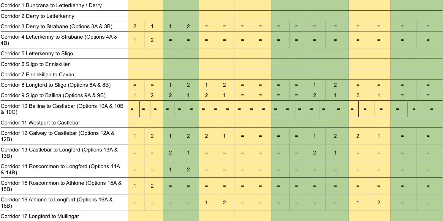
Table 6.1: Summary of Appraisal Findings: Corridor Options
SEA of the National Cycle Network Plan
SEA Theme
Corridor
Water Air Quality
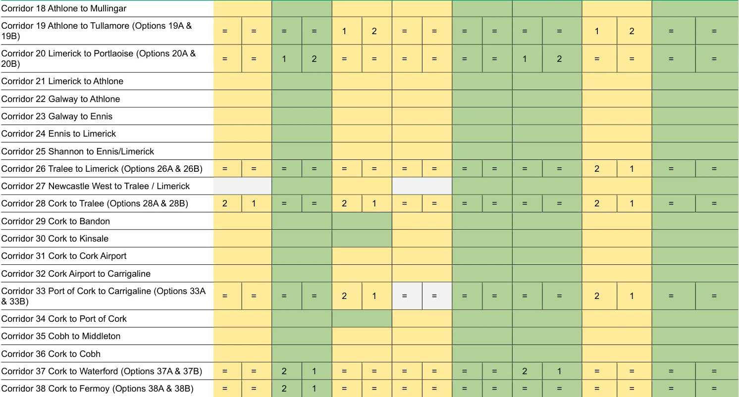
Figure from page 273
SEA of the National Cycle Network Plan
SEA Theme
Corridor
Water Air Quality
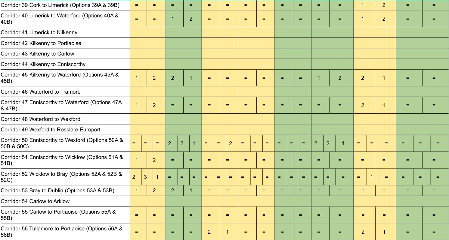
Figure from page 274
SEA of the National Cycle Network Plan
SEA Theme
Corridor
Water Air Quality
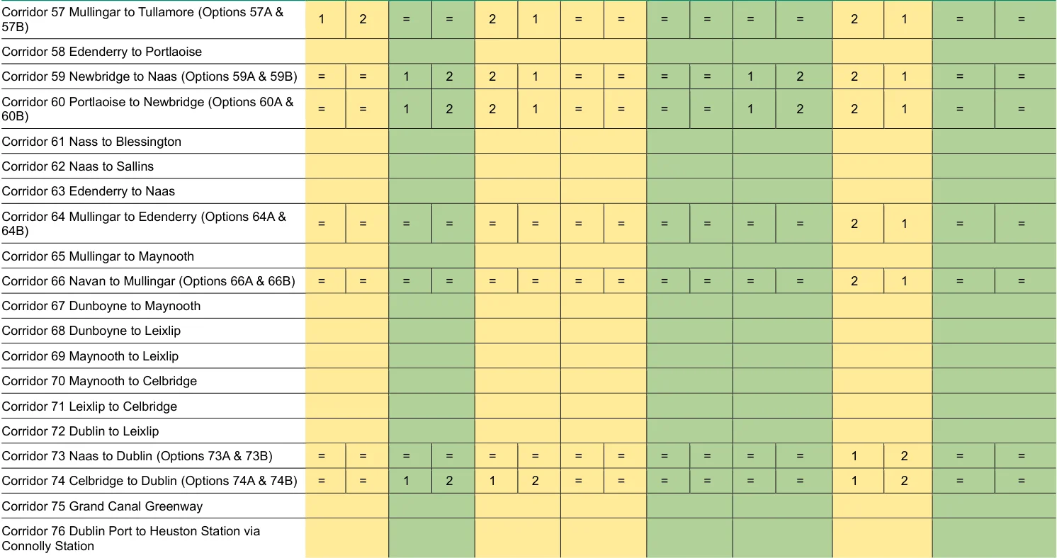
Figure from page 275
SEA of the National Cycle Network Plan
SEA Theme
Corridor
Water Air Quality
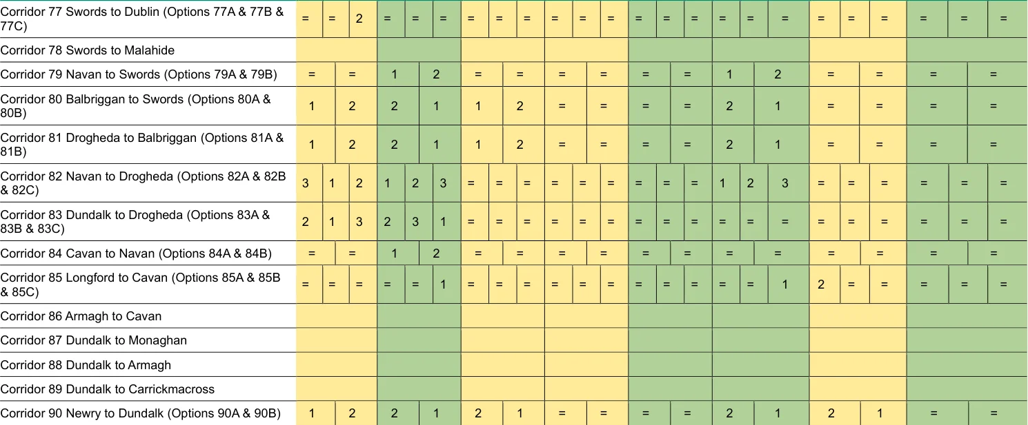
Figure from page 276
SEA of the National Cycle Network Plan SEA Environmental Report (Updated)
6.5 Preferred Approach for the NCN Plan
Following the consideration of corridor options, and following public consultation of the Plan,
the corridors highlighted in Figure 6.1 have been selected as the key components of the
preferred NCN.
These corridors are as follows:
Corridor Number (as assessed in
Corridor Name (Corridor No. following updates to Plan)
Corridor
Option
Table 6.1)
| Buncrana to Letterkenny / 1 Derry (1) | Kilkenny to Waterford (44) 45 A |
|---|---|
| Derry to Letterkenny (2) 2 | Waterford to Tramore (45) 46 |
| Derry to Strabane (3) 3 B | Enniscorthy to Waterford 47 B (46) |
| Letterkenny to Strabane (4) 4 A | Waterford to Wexford (47) 48 |
| Letterkenny to Sligo (5) 5 | Wexford to Rosslare 49 Europort (48) |
| Sligo to Enniskillen (6) 6 | Enniscorthy to Wicklow 51 A (49) |
| Enniskillen to Cavan (7) 7 | Wicklow to Bray (50) 52 B |
| Longford to Sligo (8) 8 A | Bray to Dublin (51) 53 B |
| Sligo to Ballina (9) 9 B | Carlow to Arklow (52) 54 |
| Ballina to Castlebar (10) 10 A | Carlow to Portlaoise (53) 55 A |
| Westport to Castlebar (11) 11 | Tullamore to Portlaoise 56 B (54) |
| Galway to Castlebar (12) 12 B | Mullingar to Tullamore 57 B (55) |
| Castlebar to Longford (13) 13 B | Edenderry to Portlaoise 58 (56) |
| Roscommon to Athlone (14) 15 B | Newbridge to Naas (57) 59 B |
| Athlone to Longford (15) 16 B | Portlaoise to Newbridge 60 A (58) |
| Longford to Mullingar (16) 17 | Naas to Blessington (59) 61 |
| Athlone to Mullingar (17) 18 | Edenderry to Naas (60) 63 |
| Athlone to Tullamore (18) 19 A | Mullingar to Edenderry 64 B (61) |
| Limerick to Portlaoise (19) 20 A | Mullingar to Maynooth (62) 65 |
| Limerick to Athlone (20) 21 | Navan to Mullingar (63) 66 B |
| Galway to Athlone (21) 22 | Dunboyne to Leixlip (64) 68 |
| Galway to Ennis (22) 23 | Maynooth to Leixlip (65) 69 |
| Ennis to Limerick (23) 24 | Leixlip to Celbridge (66) 71 |
| Shannon to Ennis/Limerick 25 (24) | Dublin to Leixlip (67) 72 |
| Tralee to Limerick (25) 26 B | Naas to Dublin (68) 73 A |
Prepared for: Transport Infrastructure Ireland AECOM
SEA of the National Cycle Network Plan SEA Environmental Report (Updated)
Corridor Number (as assessed in
Corridor Name (Corridor No. following updates to Plan)
Corridor
Corridor
Option
Table 6.1)
| Newcastle W. to Tralee/Limerick 27 (26) | Swords to Dublin airport (69) |
|---|---|
| Cork to Tralee (27) 28 B | Celbridge to Dublin (70) 74 A |
| Cork to Bandon (28) 29 | Grand Canal Greenway (71) 75 |
| Cork to Kinsale (29) 30 | Dublin port to Heuston Station via Connolly 76 station (72) |
| Cork to Cork airport (30) 31 | Swords to Dublin (73) 77 B |
| Cork airport to Carrigaline (31) 32 | Navan to Swords (74) 79 A |
| Port of Cork to Carrigaline (32) 33 B | Balbriggan to Swords (75) 80 B |
| Cork to Port of Cork (33) 34 | Drogheda to Balbriggan 81 B (76) |
| Cobh to Middleton (34) 35 | Navan to Drogheda (77) 82 A |
| Cork to Cobh (35) 36 | Dundalk to Drogheda (78) 83 C |
| Cork to Waterford (36) 37 B | Cavan to Navan (79) 84 A |
| Cork to Fermoy (37) 38 B | Longford to Cavan (80) 85 C |
| Cork to Limerick (38) 39 A | Armagh to Cavan (81) 86 |
| Limerick to Waterford (39) 40 A | Dundalk to Monaghan (82) 87 |
| Limerick to Kilkenny (40) 41 | Dundalk to Armagh (83) 88 |
| Kilkenny to Portlaoise (41) 42 | Dundalk to 89 Carrickmacross (84) |
| Kilkenny to Carlow (42) 43 | Newry to Dundalk (85) 90 B |
| Kilkenny to Enniscorthy (43) 44 |
Prepared for: Transport Infrastructure Ireland AECOM
SEA of the National Cycle Network Plan
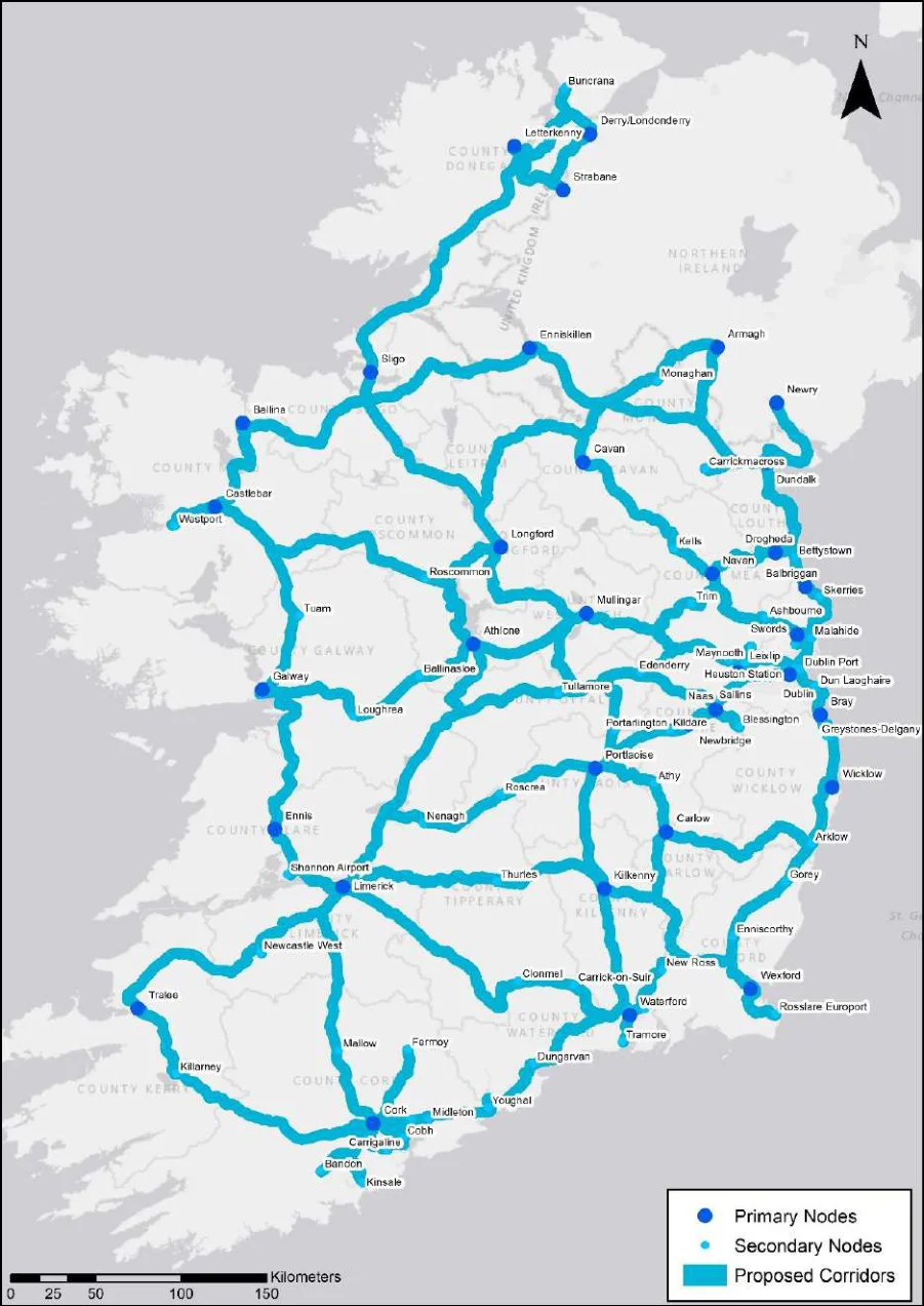
Figure 6.1: Preferred Corridors for the NCN Plan, after Consultation
Prepared for: Transport Infrastructure Ireland
SEA of the National Cycle Network Plan SEA Environmental Report (Updated)
7. Assessment of the NCN Plan
7.1 Assessment of Preferred Corridor Options
Drawing on the assessments presented in Chapter 6, and Appendix B, a summary of the
appraisal findings relating to the preferred corridor options (and following public consultation)
is presented in Table 7.1.
More detailed findings relating to the corridors can be accessed in Appendix B.
The scorings used is represented in the key below.
| Key | Description | ||
|---|---|---|---|
| Negative Impact | Indicates a potential negative environmental impact | ||
| Positive Impact | Indicates a potential positive environmental impact | ||
| Uncertain Impact | Indicates that in the absence of further information the impact is unclear | ||
| Neutral Impact | Indicates a potential neutral or no significant environmental impact |
Prepared for: Transport Infrastructure Ireland
SEA of the National Cycle Network Plan SEA Environmental Report (Updated)
SEA Theme
Corridor No. (as assessed in Section 6) and Name Updated Corridor
Population Biodiversity
Cultural Landscape Heritage
Land & Soils Water Air Quality & Health
No.92
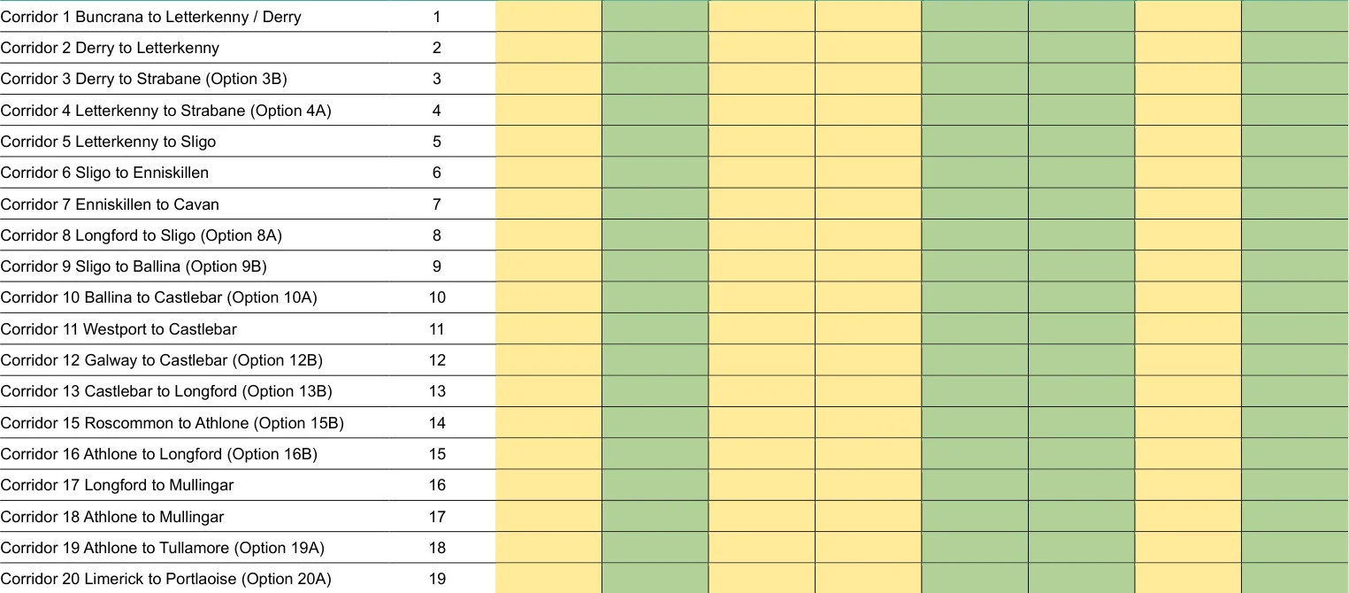
Table 7.1: Summary of Appraisal Findings: Preferred NCN Corridor Options
92 Following updates to the Plan.
SEA of the National Cycle Network Plan SEA Environmental Report (Updated)
SEA Theme
Updated Corridor No. (as assessed in Section 6) and Name Corridor
Population Biodiversity
Cultural Landscape Heritage
Land & Soils Water Air Quality & Health
No.92
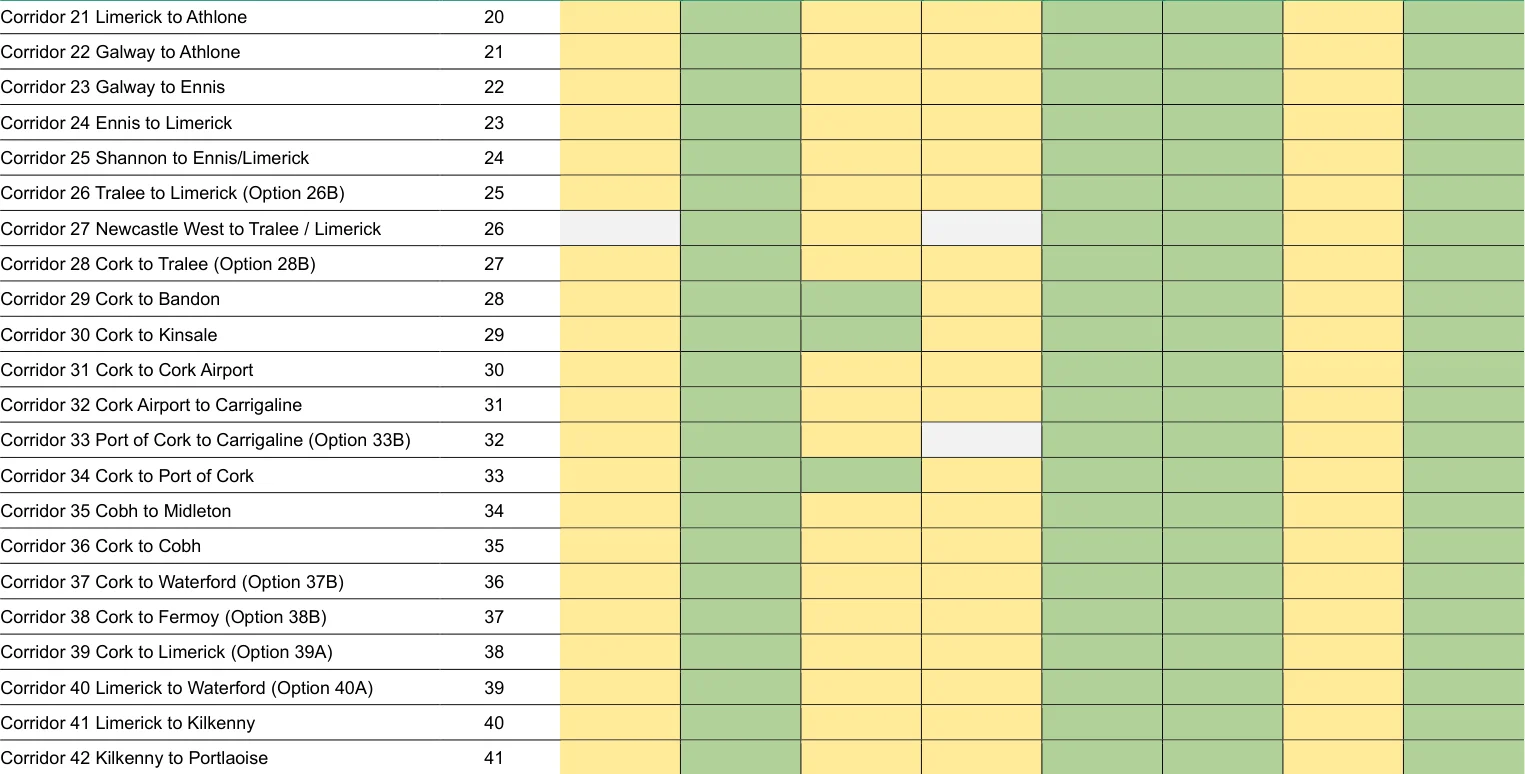
Figure from page 282
SEA of the National Cycle Network Plan SEA Environmental Report (Updated)
SEA Theme
Updated Corridor No. (as assessed in Section 6) and Name Corridor
Population Biodiversity
Cultural Landscape Heritage
Land & Soils Water Air Quality & Health
No.92
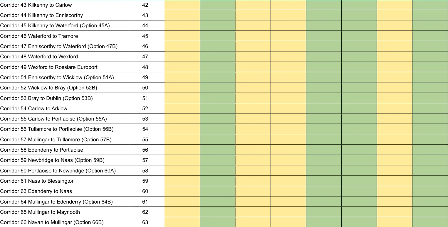
Figure from page 283
SEA of the National Cycle Network Plan SEA Environmental Report (Updated)
SEA Theme
Updated Corridor No. (as assessed in Section 6) and Name Corridor
Population Biodiversity
Cultural Landscape Heritage
Land & Soils Water Air Quality & Health
No.92
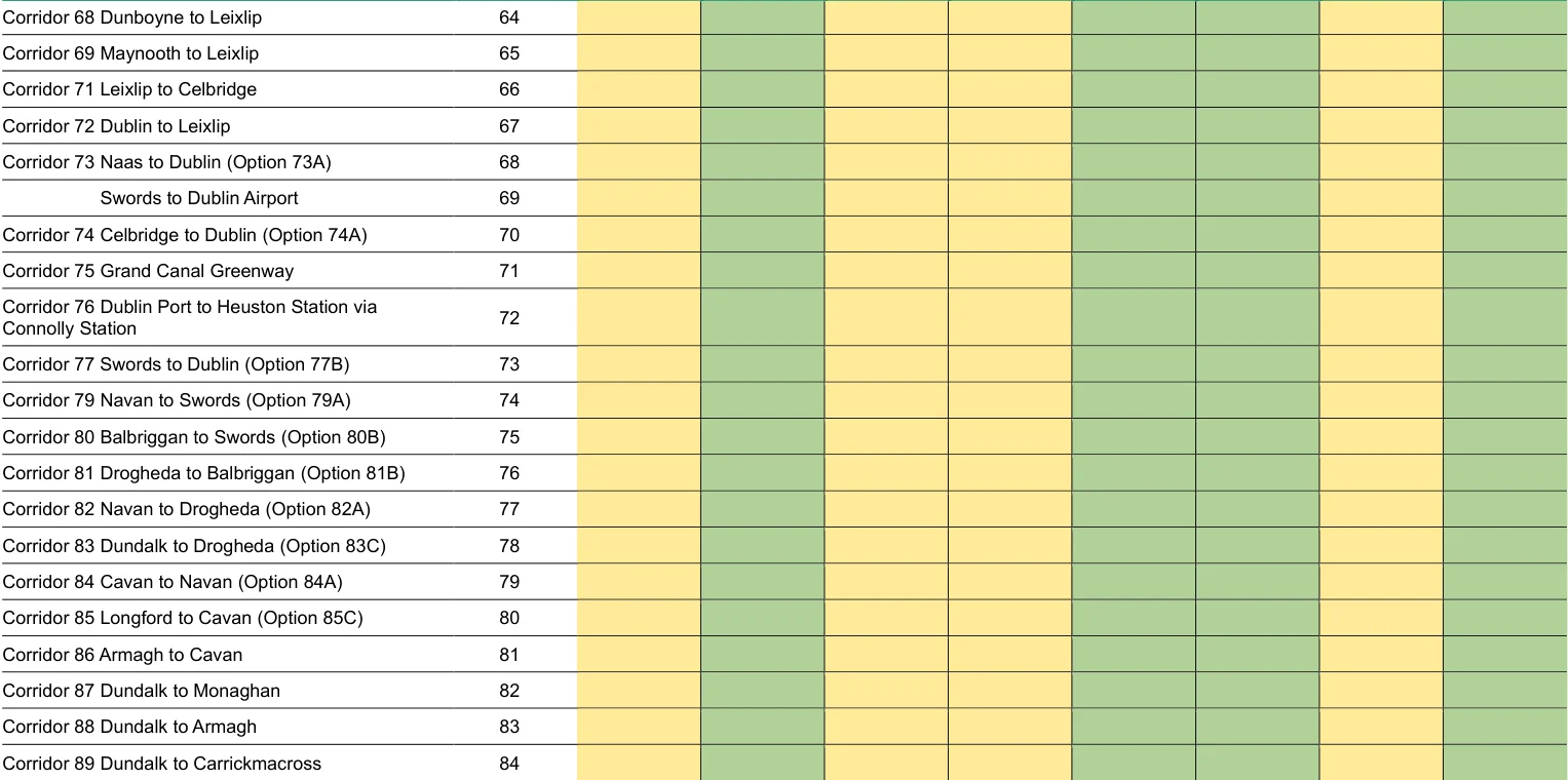
Figure from page 284
SEA of the National Cycle Network Plan SEA Environmental Report (Updated)
SEA Theme
Updated Corridor No. (as assessed in Section 6) and Name Corridor
Population Biodiversity
Cultural Landscape Heritage
Land & Soils Water Air Quality & Health
No.92
Corridor 90 Newry to Dundalk (Option 90B) 85
SEA of the National Cycle Network Plan SEA Environmental Report (Updated)
7.2 Cumulative Impacts
Cumulative effects occur from the combined impacts of policies and proposals on specific
areas or sensitive receptors.
In the context of SEA, cumulative effects can result from the combined impacts of a plan with
impacts of another plan, or the ‘inter-plan’ effects. These can affect the same receptor,
resulting in in-combination or synergistic effects. The combination of NCN proposals and other
proposals and activities has the potential to lead to cumulative effects. Examples include:
National, county and city development plans.
Development of tourism infrastructure.
Development of national and local transport plans and strategies across Ireland.
Upgrades to the National Road Network across Ireland.
Proposals to increase/manage visitor numbers across Ireland and development of
tourism infrastructure.
Activities designed to enhance national, regional and sub-regional green infrastructure
networks.
Reinstatement and/or restoration of railway lines across Ireland.
Other infrastructure development, such as minerals proposals.
Potential effects (both positive and negative) which may occur as a result of the in-combination
effects of the NCN Plan and other plans and proposals include:
Enhancements to sub-regional green infrastructure networks.
Improvements in accessibility resulting from the combined effects of enhancements to
public transport, walking and cycling networks and public realm enhancements.
Enhancements in active travel opportunities.
Cumulative impacts on ecological networks. This is from combined negative effects of
new development and associated infrastructure on habitats and biodiversity corridors.
Enhancements to green infrastructure provision facilitated through plan proposals and
other projects also have significant potential to support local, sub-regional regional and
national ecological networks. This includes through embedding the principle of
environmental net gain in scheme development.
Impacts on flood risk from the in-combination effects of new development, including
relating to surface water and fluvial flooding.
Prepared for: Transport Infrastructure Ireland
SEA of the National Cycle Network Plan SEA Environmental Report (Updated)
Cumulative and synergistic positive impacts on health and wellbeing.
Enhancements in sustainable tourism opportunities.
For many potential cumulative effects, the policy approaches proposed by the various plans
and programmes will help reduce the significance of in-combination impacts. In this respect
the NCN Plan will support numerous environmental benefits, and in many respects will help
limit the impacts of proposals taken forward through other plans and programmes. However,
monitoring for the plans and programmes will be a key means of ensuring that unforeseen
adverse environmental and socio-economic effects are highlighted, and remedial action can
be taken where adverse effects arise.
7.3 Mitigation Measures
Mitigation measures are measures envisaged to prevent, reduce and, as fully as possible,
offset significant adverse impacts of implementing the NCN Plan on the environment.
Article 5 of the SEA Directive requires that mitigation measures are proposed for significant
adverse effects identified on the environment as a result of the implementation of the plan or
programme.
As discussed above under the ‘limitations’ discussion (Section 6.3.1), given the high-level
nature of the corridors proposed for the NCN, it is not possible to propose specific mitigation
measures for each corridor. It is also not possible to propose specific enhancement measures.
Detailed mitigation and enhancement opportunities would instead be developed as part of the
design and consenting process at the scheme level, and embedded mitigation measures will
be required alongside scheme development. In addition, where appropriate, project level
Environmental Impact Assessment and Appropriate Assessment would be undertaken for
individual schemes where likely significant effects arise; these will also identify appropriate
scheme-level mitigation measures.
However, the following examples of mitigation and enhancement measures can be considered
during the development of schemes which implement the NCN Plan:
The design, location and layout of new cycle infrastructure should be sensitive to (and
reinforce) local landscape, townscape and villagescape character.
The delivery of new cycle links should be sensitive to the fabric and setting of the
historic environment and facilitate opportunities for its enhancement.
Signage and waymarking of the NCN should be designed so as not to detract from
local character, the setting of the historic environment or impact adversely on the
quality of the public realm.
Prepared for: Transport Infrastructure Ireland AECOM
SEA of the National Cycle Network Plan SEA Environmental Report (Updated)
Design, surfacing and street furniture should complement the setting of the historic
environment and local distinctiveness.
The development of off-line cycle infrastructure should appropriately recognise the
possibility for archaeological remains to be found and seek to avoid impacts on
significant remains which have been or are identified. Where found, remains should be
archaeologically recorded in order to “preserve by record” the significant aspects of the
route. This should be informed by an evaluation of the importance and significance of
the archaeological resource.
New cycle links should be delivered as key components of wider multifunctional green
infrastructure networks which deliver multiple environmental and socio-economic
benefits relating to, for example, health and wellbeing, landscape character,
biodiversity, climate change adaptation, water quality and a range of others.
Limitation of potential impacts on habitats and species from land take and loss of
vegetation and trees.
Avoidance of land take on designated biodiversity sites and sensitive habitats, and
consideration of both direct and indirect effects on these sits.
Enhancement of ecological networks alongside NCN infrastructure through
appropriate planting and green infrastructure enhancements, and where possible,
employing a premise of environmental net gain.
Delivery of well-designed and appropriate lighting which seeks to limit impacts on light
pollution and night blight, visual intrusion and ecological sensitivities.
Provision of information for NCN users on local areas of interest, such as associated
with the historic environment, cultural heritage, biodiversity assets and others.
Facilitation of the use of recycled/reused materials to reduce the use of primary
aggregates in construction and limit resource use.
Prepared for: Transport Infrastructure Ireland AECOM
SEA of the National Cycle Network Plan SEA Environmental Report (Updated)
8. Next Steps
8.1 Updates to the NCN Plan and Assessment of Changes
This Environmental Report has been published to accompany the draft NCN Plan for
consultation. Following the consultation period, comments will be reviewed and analysed. The
final NCN Plan will then be developed, with a view to adoption later in 2022. Any changes
arising to the NCN Plan will need to be assessed as part of the SEA process.
8.2 SEA Adoption Statement
SEA Regulations 16.(2)(b) require that a ‘statement’ be made available to accompany the
plan, as soon as possible after the adoption of the plan or programme. The purpose of the
SEA Statement is to outline how the SEA process has influenced and informed the NCN Plan’s
development process and demonstrate how consultation on the SEA has been taken into
account.
As the regulations outline, the SEA Statement should contain the following information:
The reasons for choosing the preferred measures for the NCN Plan as adopted in the
light of other reasonable alternatives dealt with;
How environmental considerations have been integrated into the NCN Plan;
How consultation responses have been taken into account; and
Measures that are to be taken to monitor the significant environmental effects of the
NCN Plan.
To meet these requirements, an SEA Statement will be published with the adopted version of
the NCN Plan.
Prepared for: Transport Infrastructure Ireland
SEA of the National Cycle Network Plan SEA Environmental Report
(Updated)
Appendix A: Summary of Scoping Submissions
SEA of the National Cycle Network Plan SEA Environmental Report
(Updated)
Table 1: Summary of Scoping Submissions
Environmental Authority Summary of Submission Response / Comment
- Department of Environment, Climate and Communications (DECC). (Environmental Protection and Circular Economy – Materials Management Divisions)
Strategy considered within the assessment. Specific comments are noted and addressed. Strategy has been considered and incorporated into the SEA Environmental Report as appropriate.
To include the Whole of Government Circular Economy Strategy 2022-2023 amongst the plans, policies referenced.
GSI recommend using these various data sets, when conducting the EIAR, SEA, planning and scoping processes. Use of our data or maps should be attributed correctly to ‘Geological Survey Ireland’ (GSI).
GSI would encourage use of and reference to our datasets.
A list of our publicly available datasets that may be useful to the environmental assessment and planning process.
GSI recommend that you review this list and refer to any datasets you consider relevant to your assessment. Geoheritage GSI welcome reference to our audited and unaudited geological heritage sites in Section 5.6.4.1 ‘Geological Heritage’, of the draft SEA Report.
Suggestions for data sources and guidelines and comments have been taken into account and considered through the assessment stages.
Important geological and geomorphological sites throughout the country for designation as geological NHAs (Natural Heritage Areas). Addressed by the Geoheritage Programme in GSI.
Currently 27 local authority areas have completed geological heritage audits, and a further three are currently under way, (Limerick, Cork County and Cork City), creating an almost national level of audited sites. Completed audits for other counties and local authority areas can be viewed on the Map viewer. Culture and Tourism Geoparks have bolstered tourism in various parts of Ireland and helped to increase its levels in areas that were previously not as popular with tourists. We would encourage TII to develop the promotion of the geological value of sites close to cycle infrastructure. Groundwater GSI has completed Groundwater Protection Schemes (GWPSs) in partnership with Local Authorities, and there is now national coverage of GWPS mapping. GSI recommend using the groundwater maps on the Map viewer.
- Geological Survey Ireland under DECC
GWClimate is a groundwater monitoring and modelling project. This data may be useful in relation to Flood Risk Assessment (FRA) and management plans. Maps and data are available on the Map viewer.
GSI has completed Groundwater Protection Schemes (GWPSs).
Summary of Submission
Geological Mapping GSI maintains online datasets of bedrock and subsoils geological mapping that are reliable and accessible.
GSI would encourage the use this data.
Information on the bedrock and Quaternary 3D models of Dublin is available.
Information and download instructions for the Quaternary 3D model of Cork is available. Geotechnical Database Resources GSI encourage the use of the national geotechnical database and viewer as part of any baseline geological assessment of the proposed development as it can provide invaluable baseline data for the region or vicinity of proposed development areas.
This information may be beneficial and cost saving for any site-specific investigations that may be designed as part of any cycle infrastructure development projects. Geohazards GSI recommend that geohazards be taken into consideration, especially when developing areas where these risks are prevalent, and we encourage the use of our data when doing so. GSI has information available on landslides in Ireland via the National Landslide Database and Landslide Susceptibility Map.
GSI has engaged in a national project on Groundwater Flooding. The data from this project may be useful in relation to Flood Risk Assessment (FRA) and management plans. Natural Resources (Minerals/Aggregates) GSI highlights the consideration of mineral resources and potential resources as a material asset which should be explicitly recognised within the environmental assessment process.
GSI provides data, maps, interpretations and advice on matters related to minerals, their use and their development.
The Active Quarries, Mineral Localities and the Aggregate Potential maps are available on the Map Viewer.
GSI would recommend use of the Aggregate Potential Mapping viewer to identify areas of High to Very High source aggregate potential within the area.
GSI would recommend use of our data and mapping viewers to identify and ensure that natural resources used in the proposed cycle infrastructure development projects are sustainably sourced from properly recognised and licensed facilities, and that consideration of future resource sterilization is considered. Geochemistry of Soils, Surface Waters and Sediments GSI note reference to potential issues to land, soil and geology in Section 5.6.6, and recommend use of the following datasets that may be of benefit.
GSI provides baseline geochemistry data for Ireland as part of the Tellus programme. Baseline geochemistry data can be used to assess the chemical status of soil and water at a regional scale and to support the assessment of existing or potential impacts of human activity on environmental chemical quality.
Summary of Submission
At present, mapping consists of the border, western and midland regions. Data is available at https://www.gsi.ie/enie/data-and-maps/Pages/Geochemistry.aspx . This page also hosts urban geochemistry mapping (Dublin SURGE project), Geochemical Mapping of Agricultural and Grazing Land Soil of Europe (GEMAS) and lithogeochemistry (rock geochemistry) from southeast Ireland datasets. Geological Survey Ireland and partners are undertaking applied geochemistry projects to provide data for agriculture (Terra Soil), waste soil characterisation (Geochemically Appropriate Levels for Soil Recovery Facilities) and mineral exploration (Mineral Prospectivity Mapping). Historic Mines The EPA, GSI and the former Exploration & Mining Division undertook a joint project entitled “Historic Mine Site - Inventory and Risk Characterisation (HMS - IRC)”. This project carried out detailed site investigations and characterisation on priority historic mine sites in the country.
A final report and a GIS geodatabase was produced on completion of the project. The project provides an understanding of the impacts of historic mining sites in Ireland and their status at the time of the study. Reports and maps are available. Marine and Coastal Unit GSI Marine and Coastal Unit in partnership with the Marine Institute, jointly manages INFOMAR, Ireland’s national marine mapping programme; providing key baseline data for Ireland’s marine sector.
Of particular interest to tourism is the extensive database of shipwrecks mapped by the INFOMAR programme.
GSI recommend use of our Marine and Coastal Unit datasets available on our website and Map Viewer.
The Marine and Coastal Unit also participate in coastal change projects such as CHERISH (Climate, Heritage and Environments of Reefs, Islands, and Headlands) and are undertaking mapping in areas such as coastal vulnerability and coastal erosion. Further information is available. Coastal Vulnerability Index GSI is undertaking a new coastal vulnerability mapping initiative.
Maps produced provide an insight into the relative susceptibility of the Irish coast to adverse impacts of sea-level rise through the use of a Coastal Vulnerability Index (CVI). Currently the project is being carried out on the east coast and will be rolled out nationally. Physiographic Units Physiographic Units are cartographic representations of the broad-scale physical landscape of a region.
They are valuable for regional land-use planning, and in studies of the influence of physical landscape on the ecological environment.
This map is produced in support of the actions to be implemented in National Landscape Strategy for Ireland 2015- 2025.
Physiographic Units map data can be viewed online under the Physiographic Units tab on the online Map Viewer. Guidelines The following guidelines may also be of assistance:
SEA of the National Cycle Network Plan SEA Environmental Report
(Updated)
Environmental Authority Summary of Submission Response / Comment
Institute of Geologists of Ireland, 2013. Guidelines for the Preparation of the Soils, Geology and Hydrogeology Chapters of Geology in Environmental Impact Statements.
National Roads Authority, 2009. Guidelines on Procedures for Assessment and Treatment of Geology, Hydrology and Hydrogeology for National Road Schemes. Other Comments Should development go ahead, GSI would much appreciate a copy of reports detailing any site investigations carried out.
The data would be added to GSI’s national database of site investigation boreholes, implemented to provide a better service to the civil engineering sector.
GSI’s Publicly Available Datasets Relevant to Planning, EIA and SEA processes, attached.
The EPA is one of the statutory environmental authorities under the SEA Regulations.
Our role is to focus on promoting the full and transparent integration of the findings of the Environmental Assessment into the Plan and advocating that the key environmental challenges for Ireland are addressed as relevant and appropriate to the plan.
State of the Environment Report has been reviewed and information included in the updated baseline overview.
Our functions as an SEA environmental authority do not include approving or enforcing SEAs or plans
Submission highlights some additional key plans and programmes for consideration (Appendix 1), as well as some comments on the SEA objectives and some additional resources (Appendix II) that may assist the SEA.
The monitoring programme for the SEA process will be developed following consultation on the NCN Plan and set out in the SEA Adoption Statement.
The EPA may provide additional comments upon receipt of the SEA Environmental Report and draft Plan at the next stage of the SEA process. State of the Environment Report – Ireland’s Environment 2020 In preparing the Plan and SEA, the recommendations, key issues and challenges described within our State of the Environment Report Ireland’s Environment – An Integrated Assessment 2020 (EPA, 2020) should be considered, in preparing the Plan and SEA as relevant and appropriate.
- Environmental Protection Agency (EPA)
Limitations of the assessment process have been acknowledged in the Environmental Report.
Chapter 11 - Environment and Transport. A sustainable mobility transformation is required, with the next decade crucial, whereby necessary journeys are made by sustainable modes such as walking, cycling and public transport, followed by using electric vehicles where unavoidable. Shifting to these modes is an essential part of a sustainable and climate-neutral transition for the transport sector.
Policy and plan review and baseline information has been updated to reflect comments.
Chapter 14 - Environment, Health and Wellbeing. Providing health-promoting environments is an essential requirement for healthy, thriving and inclusive communities. Providing integrated health-promoting environments in urban planning can promote more active travel, reduce air pollution through the use of fewer private vehicles, act as quiet areas buffered from environmental noise and improve the physical and mental health of those cycling.
Other comments have been considered in preparation of the Environmental Report and undertaking of the assessments.
Other chapters in the report relating to Air Quality (Chapter 3) and Noise (Chapter 4) may also be useful to consider in the preparation of the SEA.
Transition to a low carbon climate resilient economy and society. Monitoring, Review & Reporting:
Summary of Submission
The Plan should include a commitment to implement the environmental monitoring programme and associated reporting. It would be useful to include a separate section on ‘Monitoring, Review and Reporting’ within the Plan, setting out the provisions for monitoring and reporting on the implementation of the Plan and any periodic reviews of the Plan. There may be merits in aligning the periodic reviews of the Plan with existing cyclical reporting e.g., Ireland’s Environment, National Planning Framework, etc.
In between review periods for the Plan, we recommend that Plan-related implementation reports are published annually, or biennially, as appropriate. We recommend aligning this Plan related monitoring / reporting with the environmental monitoring required under the SEA legislation.
The SEA-related monitoring should address positive, negative and cumulative effects where they are likely to occur and should include provision for on-going review to facilitate an early response to any environmental issues that may arise.
The Environmental Report should specify the monitoring frequency and responsibilities and include provisions for reporting on the monitoring. To avoid duplication in data collection, the same indicators should be used for the planrelated and SEA-related monitoring where possible. Data & Knowledge Gaps The Plan should identify any significant data and knowledge gaps, include commitments to help address these on a priority basis during the implementation phase of the Plan. Alignment with other key plans and programmes We recommend including schematics in the Plan and SEA Environmental Report, showing the links and key interrelationships with other key relevant national, regional, sectoral and environmental plans.
The relevant objectives and policy commitments of the NPF, RSES should be aligned with and considered, as appropriate. In particular, the Plan should take account of the National Strategic objective in the NPF on Sustainable Mobility where investment will be made to progressively put in place sustainable alternatives to those currently available. Furthermore, the Plan should show clear connectivity between the objectives and goals of other national, regional and local transport strategies, e.g. metropolitan area transport strategies.
List of plans / programmes included in scoping report should be reviewed to ensure that it does not include legislation that has been revoked or previous versions of plans, e.g. All Ireland Pollinator Plan, River Basin Management Plan.
In addition to the plans and programmes listed, it may also be useful to consider the following in the SEA: Fáilte Ireland Visitor Experience Development Plans; ─ Metropolitan Area Transport Plans; ─ Regional Tourism Plans (currently being developed by Fáilte Ireland); ─ Healthy Cities Project; ─ Clean Air Strategy – currently released for consultation ─ Proposed Solid Fuel Regs. ─ Dublin Action Plan for Nitrogen Dioxide (December 2021). ─ WHO Global Air Quality Guidelines 2021. ─
Summary of Submission
Urban Transport Related Air Pollution (UTRAP) Working Group. ─ Research Department of Transport - Demand Management Study, 2021.
This study helps to better understand what drives transport demand and how a greater shift to more sustainable ─ and healthier forms of travel can be encouraged in Ireland’s five largest urban centres. NEAR Health Research Project. The toolkit highlights (1) how people value and experience nature, health and wellbeing, (2) the barriers and ─ bridges to nature connection, (3) what people want from their healthy future environment and (4) how naturebased activities can benefit people’s health and wellbeing and enable them to develop a deeper connection with their wider community and with nature. Connecting with nature helps people to care more for the environment and promotes positive wellbeing. Green and Blue Spaces and Health: A Health-led approach. This research was based on a 12-month desk study that modelled, for identified sample sites, the relationships ─ between health indicators and the availability of green and blue infrastructure (GBI). Eco-Health: Ecosystem Benefits of Greenspace for Health. The Eco-Health project seeks to inform public health and spatial planning policy and the important interlinkages ─ between environmental quality and health and well-being. Commitment Biodiversity The Plan should integrate available habitat mapping and take account of important green infrastructure/ecological corridors in the Plan area. A commitment should be included to protect designated national and European sites in implementing the Plan. Aspects such as recognising the need to control and manage the potential spread of invasive species should also be considered. Additionally, the National Biodiversity Action Plan and All-Island Pollinator Plan should be integrated into the Plan. Scope of the SEA The Plan should clearly set out the scope, remit and implementation related elements of the Plan. These will have implications for the SEA, in terms of guiding the level of assessment applicable at the appropriate level for the Plan. Where it is envisaged that measures proposed in the Plan will be implemented via other plans, which themselves have been or will be subject to SEA, this should be explained in the Environmental Report and taken into account in the assessment. Available Guidance & Resources SEA process guidance and checklists.
Inventory of spatial datasets relevant to SEA.
Topic specific SEA guidance (including Good practice guidance on Cumulative Effects Assessment (EPA, 2020), Guidance on SEA Statements and Monitoring (EPA, 2020), Integrating climatic factors into SEA (EPA, 2019), Developing and Assessing Alternatives in SEA (EPA, 2015), and Integrated Biodiversity Impact Assessment (EPA, 2012)).
SEA of the National Cycle Network Plan SEA Environmental Report
(Updated)
Environmental Authority Summary of Submission Response / Comment
Environmental Sensitivity Mapping (ESM) Webtool. Available at: www.enviromap.ie
EPA SEA Search and Reporting Tool. Available at: https://gis.epa.ie/EPAMaps/SEA
EPA WFD Application. Available at: www.Catchments.ie.
EPA AA Geo Tool. Available at: https://gis.epa.ie/EPAMaps/AAGeoTool
DAERA would like the SEA Environmental Report to contain a clear statement indicating the opinion about whether or not the implementation of the of the strategy is likely to have a significant effect on Northern Ireland, in combination with any identified measures envisaged to prevent, reduce and as fully as possible offset any significant adverse effects on the environment. Natural Environment Division (NED) Comments NIEA NED works to ensure that Northern Ireland’s special natural environment, including its flora and fauna and landscapes, is conserved, enhanced and managed for the benefit of this and future generations, thereby contributing to sustainable development.
We note that it is proposed to integrate the network with NI as appropriate and that some of the broadly identified corridors will reach the border with NI and may have potential to have an effect on NI. Transboundary issues don’t appear to have been highlighted specifically within the scoping report.
Additional information relating to Northern Ireland’s environment has been included, including baseline information. Transboundary effects have been assessed and presented in the Environmental Report. Data sources have been considered through updates to the baseline information relating to Northern Ireland. Comments related to AA have been noted and fed back to AA team.
We advise that transboundary issues are taken into account in the Environmental report.
- Department of Agriculture, Environment and Rural Affairs (DAERA): Northern Ireland Environment Agency (NIEA)
We would highlight consideration of the following issues including the potential disturbance to/impact on NI / ROI migratory/mobile species such as salmon, for example Lough Melvin Special Area of Conservation which lies within both NI and the ROI. Cross border designated sites, European sites in NI adjacent to or with pathways to/from the ROI, priority habitats, river basins, and other landscape types also require special attention as ecological functionality and ‘views’ of landscape cross political boundaries.
The SEA should consider all potential impacts including those which may impact NI both directly and indirectly.
NI baseline conditions and relevant plans and programmes will need to be considered as part of the Environmental Report.
Other than the issues highlighted above NED are content with the overall approach to SEA and the issues that will be addressed including the consideration of how Environmental impacts will be addressed and mitigated, this should include potential impacts on NI.
NED are in agreement and welcome the completion of a Habitats Regulations Assessment (AA) in parallel to the SEA.
We welcome that mitigation and monitoring will be put in place in due course and look forward to the opportunity to comment further as the process develops. Data Worth Considering The Wildlife (NI) Order 1985 (as amended).
Wildlife and Natural Environment Act (NI) 2011.
The Conservation (Natural Habitats, etc.) Regulations (Northern Ireland) 1995 (as amended).
SEA Environmental Report
Summary of Submission Response / Comment
The Environment (NI) Order 2002.
The Planning (Environmental Impact Assessment) Regulations (Northern Ireland) 2017.
The Strategic Planning Policy Statement (SPPS) for Northern Ireland.
Planning Policy Statements (PPS – in particular PPS2 and PPS18). It should be noted that the PPS’s will be superseded by Local Development Plans when they are adopted.
Biodiversity Strategy for NI to 2020 https://www.daera-ni.gov.uk/publications/biodiversity-strategy-northern-ireland- 2020-0
Draft Environment Strategy https://www.daera-ni.gov.uk/consultations/esni-public-discussion-document
The Draft NI peatland policy: https://www.daera-ni.gov.uk/consultations/ni-peatland-strategy-consultation
The Draft Green Growth Strategy.
Northern Ireland Energy Strategy 2050. Other useful information sources NI State of the Environment Reports: https://www.daera-ni.gov.uk/publications/state-environment-report-2013
NI Environmental Statistics Reports: https://www.daera-ni.gov.uk/articles/northern-ireland-environmental-statisticsreport Other Relevant Web-Links Designated Scientific Sites: www.daera-ni.gov.uk/landing-pages/protected-areas
Regional Landscape Character Map viewer: https://www.daera-ni.gov.uk/services/regional-landscape-characterareas-map-viewer
DAERA - map browser for NI protected sites and known priority habitat: www.daera-ni.gov.uk/services/naturalenvironment-map-viewer Natural Environment Datasets www.daera-ni.gov.uk/articles/download-digital-datasets
AA should refer to the status of habitats and species in the relevant reports available on the JNCC website as follows: UK Article 17 report for the Habitats Directive https://jncc.gov.uk/our-work/article-17-habitats-directive-report-2019/ and the UK Article 12 report for the Birds Directive https://jncc.gov.uk/our-work/european-reporting/#birds-directivereporting
Please note following the decision of the United Kingdom to leave the European Union, the collective term of “Natura 2000” sites the network of European protected sites are known as “National Site Network” sites within NI. Climate Change Unit comments Climate Change Mitigation Branch refers the Transport Infrastructure Ireland to the requirements laid out within the UK Climate Change Committee’s (CCC) Sixth Carbon Budget Link: https://www.theccc.org.uk/publication/sixth-carbon-budget/
SEA of the National Cycle Network Plan SEA Environmental Report
(Updated)
Environmental Authority Summary of Submission Response / Comment
The CCC recently published its UK Climate Risk Independent Assessment 2021 which identifies the risk and opportunities posed by CC over the next five years. A summary for NI: https://www.ukclimaterisk.org/independentassessment-ccra3/national-summaries/ Drinking Water Inspectorate Comments We are appreciative of the consideration given to Article 7 of the WFD: areas designated for the abstraction of water intended for human consumption. Consultation with the NI primary water undertaker (Northern Ireland Water Ltd (NI Water)) is routinely encouraged as the nationwide basins are utilised by NI Water to provide the public supply of water. Consideration should be given to the location of any infrastructure and protection of Drinking Water Protected Areas.
If public drinking sources could be impacted, mitigation actions must be provided to ensure quality / sufficiency of supply.
Consultation with NI is also encouraged (early stage), in order to establish capability of the public water system infrastructure if required, e.g., increase in tourism leading to an increased demand for supply.
Furthermore, a development must not impact on either the quality or sufficiency of a private water supply, and mitigation measures must be put in place, where required, in the protection of such drinking water supplies. Quality standards for private supplies in Ireland are detailed in European Communities (Drinking Water) Regulations 2014 (S.I. 122 of 2014) which is already included in the scoping document. For works which extend to NI, The Private Water Supplies Regulations (Northern Ireland) 2017 regulate the water quality.
Dependent on the scale, type, location and the potential impacts the proposal may have on such supplies the developer should, if appropriate, undertake a scoping exercise to determine the location of any private water supplies. Details on undertaking a search for potential private water supplies in NI available at: Drinking Water Inspectorate Viewer (daera-ni.gov.uk) Water Management Unit Comments The SEA should consider all transboundary issues, including the potential disturbance to/impact on NI / ROI migratory / mobile species such as salmon, for example within the Lough Melvin Special Area of Conservation which lies within both NI and the ROI. Such species rely and can be impacted upon water quality and water resource issues.
Cross border river basins require special attention as ecological functionality cross jurisdictional boundaries. The SEA should consider all potential impacts including those which may impact NI both directly and indirectly.
HED operate via a Service Level Agreement with colleagues in DAERA in relation to SEA. HED welcomes that cultural heritage has been scoped in for assessment, and that the plan proposals seek to integrate with existing and proposed cycling infrastructure in NI. Consideration and assessment of likely impacts on transboundary heritage assets will therefore be required in relation to this topic in the Environmental Report.
Comments on transboundary elements noted.
- Department for Communities: Historic Environment Division (HED)
Comments on reuse and rejuvenation of heritage assets noted and opportunities to enhance understanding of the historic environment considered throughout the assessment.
A large number of heritage assets predate the border itself and some, which have the potential to be utilized as cycle routes, such as canals, disused railways etc. The transboundary qualities such as the inter-relationships of sites, buildings and places and the potential effects with regard to impacts on their settings and the understanding and the experience of them should also be considered.
HED welcomes the intent of the plan to make the historic environment more accessible to the public through

Figure from page 299
SEA Environmental Report
(Updated)
Summary of Submission Response / Comment
opportunities to conserve or reuse heritage assets, e.g., industrial or vernacular buildings/ structures as ancillary facilities for cyclists would serve to meet Cultural Heritage Objectives outlined in 5.10.7. Opportunities to enhance understanding of local heritage along cycle routes e.g., through information points, signage etc.
Additional policies and plans included in context review.
Acknowledging the NCN plan will identify, at a strategic-level, key corridors for interventions and set the framework for subsequent plans and projects which have the potential for significant effects on transboundary cultural heritage, the relevant international conventions. International Conventions Convention for the Protection of the Architectural Heritage of Europe (Granada, 1985).
Convention for the Protection of the Archaeological Heritage of Europe (Valletta, 1992). Legislation Fisheries Act 2020.
Planning Act (Northern Ireland) 2011.
Historic Monuments and Archaeological Objects (Northern Ireland) Order 1995.
Protection of Wrecks Act 1973. Regional Strategies and policies Regional Development Strategy 2035 (infrastructure-ni.gov.uk) - Spatial strategy for NI.
Archaeology 2030 - A Strategic Approach for Northern Ireland (niheritagedelivers.org).
Strategic Planning Policy Statement, Paragraphs 6.1-6.30 outlines the strategic planning policy around heritage assets in NI.
HED on behalf of DfC maintains and augments the Historic Environment Record of Northern Ireland (HERoNI), which includes records of designated and non-designated heritage assets. This information may aid understanding of the historic landscape context and heritage assets. This should be used to understand where there is a likelihood or potential for impact on cultural heritage, the associated constraints, and potential mitigation measures.
Datasets are available at Historic Environment Digital Datasets and can also be viewed through our historic environment map viewer Historic Environment Map Viewer.
SEA of the National Cycle Network Plan
Appendix B: Corridor Options Assessment Tables
Prepared for: Transport Infrastructure Ireland
National Cycle Network
This appendix includes a series of tables presenting the assessment of the corridor options considered
for the NCN as ‘reasonable alternatives’ through the SEA.
These options, which have been mapped below, explore different potential corridors for linking the
nodes identified for the NCN.
The tables presented in this appendix examine the likely effects of the corridor options in relation to
each of the SEA Themes. These utilise the scorings represented in the key below. Where two or more
options have been proposed between nodes, a ranking of the relative sustainability merits has also
been provided, with ‘1’ as the option deemed to be most favourable in relation to the SEA Theme.
Key:
| Negative | ||
|---|---|---|
| Neutral impact | ||
| Positive impact | ||
| Uncertain impact |
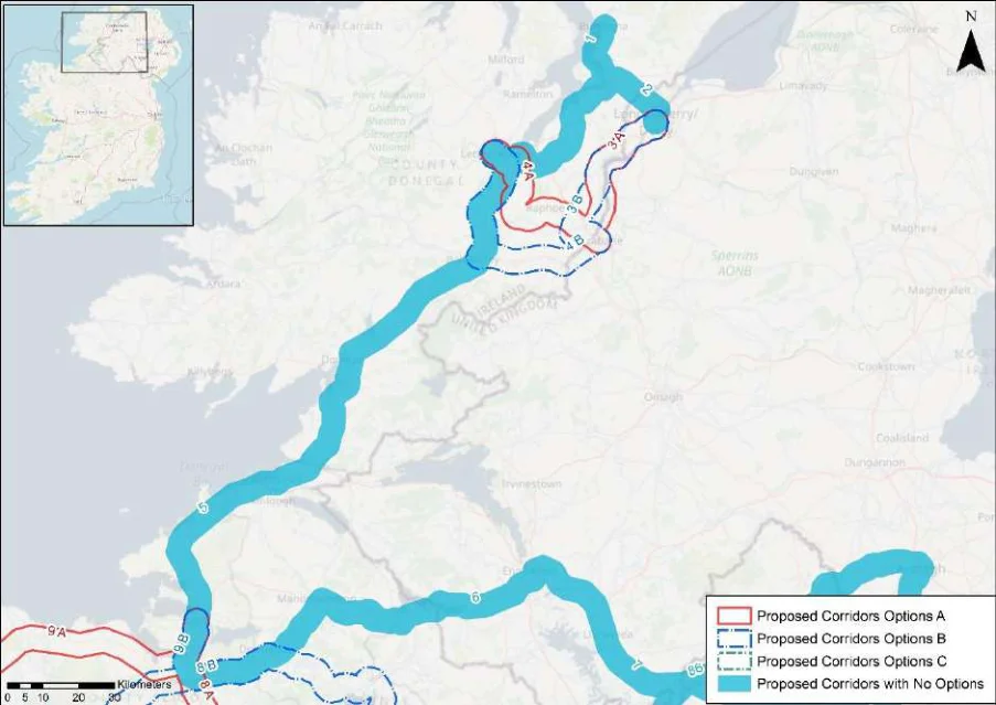
Figure from page 302
Figure B1: Map of corridor options 1, 2, 3, 4 and 5
Appendix B: Corridor option assessment tables
National Cycle Network SEA Environmental Report (Updated)
Table 1. Appraisal Relating to Corridor 1 Buncrana to Letterkenny / Derry
Summary of the Potential Effects Associated with Corridor 1 Buncrana to SEA Theme Letterkenny / Derry
| Biodiversity The corridor traverses along the edge of Lough Swilly Special Area of Conservation (SAC) and Special Protection Area (SPA), and Lough Swilly Including Big Isle, Blanket Nook & Inch Lake proposed Natural Heritage Area (pNHA), from approximately Buncrana to Magherbeg. Land take requirements are not known at this stage; however, it is anticipated the route would utilise existing transport infrastructure where practicable. Any works within or adjacent to the designated sites could result in potential significant impacts. These designated sites and key sensitivities associated with the designations would need to be considered when determining the final route during subsequent scheme development. | Uncertain |
|---|---|
| Population and The corridor would link Derry with Buncrana and Letterkenny. The route would support Human Health accessibility to the wide range of services and facilities available in Derry from settlements along the route, and also support accessibility to the amenities available in Buncrana (population c.6750) and Letterkenny (population c.19,300). An enhancement of accessibility by active travel modes will promote social inclusion and the quality of life of residents and support health and wellbeing. The corridor also has the potential to bring benefits for the visitor economy along the route and support community vitality. | Positive |
| Land and Soils Land uses along the proposed corridor / in the area varies and includes areas of urban fabric (artificial surfaces) in Buncrana and Letterkenny and sport and leisure facilities (artificial surfaces), beaches, dunes, sands (forest and semi-natural areas), intertidal flats (wetlands) and pastures (agricultural areas) as per CORINE 2018. Should the route primarily involve the reallocation of road space, loss of land and loss of productive agricultural land is unlikely to be significant. | Uncertain |
| Water Several watercourses occur along the route of the proposed corridor, including the Mill and Skeoge watercourses. The WFD status of these watercourses were ‘poor’ during the 2013-2018 monitoring period. The watercourses within the proposed corridor ranges from ‘at risk’ to ‘under review’. | Uncertain |
| Air Quality The route occurs in an area considered to be of ‘Good’ air quality. The route will provide a safe cycle route between Buncrana and Magherbeg. This will promote a modal shift to active modes of travel which will in turn support ongoing improvements to air quality in the area. | Positive |
| Climate Change The development of the corridor as part of the NCN would promote a shift to active modes of travel from higher emission modes, including the private car. This will support a limitation of greenhouse gas emissions from transport. The corridor may cross (and potentially negatively/positively impact on) areas of flood risk. Whilst impacts on flood risk, and, more broadly, climate change adaptation, depends on the detailed route of the corridor and scheme design, there would be a need to ensure that the delivery of the corridor supports the resilience of the local area to the potential effects of climate change. | Uncertain |
| Cultural Heritage A range of cultural heritage assets are present within the proposed corridor, such as a Megalithic tomb (DG038-011) and a bridge (Reg. No. 40815015). Given part of the proposed corridor is located along a historic railway line, sensitive development of the corridor as a cycle route offers the potential for the rejuvenation and enhanced enjoyment of this heritage asset. However, the proposed corridor also has the potential to impact on the setting of other cultural heritage (archaeological) assets which may occur along the proposed corridor. | Uncertain |
| Landscape The proposed corridor, given it is likely to follow existing transport infrastructure, is unlikely to lead to significant impacts on landscape character. It also offers opportunities to enhance the quality of the public realm, if high quality design and layouts are integrated within subsequent schemes. More broadly, the implementation of the corridor will support active travel modes, which are modes of transport with limited impacts on landscape character. Through promoting active travel modes, the corridor also offers opportunities to support an enhanced understanding and enjoyment of the special qualities and intrinsic character of the landscape in the vicinity of the corridor. | Positive |
Appendix B: Corridor option assessment tables
National Cycle Network
Table 2. Appraisal Relating to Corridor 2 Derry to Letterkenny
SEA Theme Summary of the Potential Effects Associated with Corridor 2 Derry to Letterkenny
| Biodiversity The corridor traverses the Lough Swilly SAC, SPA, and Lough Swilly Including Big Isle, Blanket Nook & Inch Lake pNHA near Inch Level and along a passageway crossing Drongawn Lough near Magheramore. These designated sites and key sensitivities associated with the designations would need to be considered when determining the final route during scheme development. Land take requirements are not known at this stage; however, it is anticipated the route would utilise existing infrastructure where practicable. | Uncertain |
|---|---|
| Population and The corridor would link Derry with Letterkenny. The route would support accessibility to the Human Health wide range of services and facilities available in Derry from settlements along the route, and also support accessibility to the amenities available in Letterkenny (population c.19,300). This includes from Newtowncunningham. An enhancement of accessibility by active travel modes will promote social inclusion and the quality of life of residents and support health and wellbeing. The corridor also has the potential to bring benefits for the visitor economy along the route and support community vitality. | Positive |
| Land and Soils Land use along the proposed corridor / in the area varies and includes areas of urban fabric (artificial surfaces), industrial or commercial units (artificial surfaces) in Derry City and Letterkenny and also areas of pastures (agricultural areas), non-irrigated arable land (agricultural areas) and complex cultivation patterns (agricultural areas) as per CORINE 2018. Should the route primarily involve the reallocation of road space, loss of land and loss of productive agricultural land is unlikely to be significant. Should the route require some land-take (from agriculture), the impact to likely to be significant / uncertain. | Uncertain |
| Water Several watercourses occur along the route of the proposed corridor, including Dooballagh Burn and Leslie Hill Stream and the Swilly Estuary. The WFD status of these watercourses ranged between ‘good’ and ‘poor’ during the 2013-2018 monitoring period. The watercourses within the proposed corridor ranged from ‘at risk’ to ‘under review’. | Uncertain |
| Air Quality The route occurs in an area considered to be of ‘Good’ air quality. The route will provide a safe cycle route between Derry City and Letterkenny. This will promote a modal shift to active modes of travel which will in turn support ongoing improvements to air quality in the area. | Positive |
| Climate Change The development of the corridor as part of the NCN would promote a shift to active modes of travel from higher emission modes, including the private car. This will support a limitation of greenhouse gas emissions from transport. The corridor may cross (and potentially negatively/positively impact on) areas of flood risk. Whilst impacts on flood risk, and, more broadly, climate change adaptation, depends on the detailed route of the corridor and scheme design, there would be a need to ensure that the delivery of the corridor supports the resilience of the local area to the potential effects of climate change. | Positive |
| Cultural Heritage A range of cultural heritage assets are present within the proposed corridor, such as a ringfort (DG047-007), mill (Reg. No. 40904724) and railway station (Reg. No. 40502131). The development of the cycle corridor offers the potential for the rejuvenation and enhanced enjoyment of cultural heritage assets. However, the proposed corridor also has the potential to impact on the setting of archaeological assets which occur along the proposed corridor. | Uncertain |
| Landscape The proposed corridor, given it is likely to follow existing transport infrastructure, is unlikely to lead to significant impacts on landscape character. It also offers opportunities to enhance the quality of the public realm, if high quality design and layouts are integrated within subsequent schemes. More broadly, the implementation of the corridor will support active travel modes, which are modes of transport with limited impacts on landscape character. Through promoting active travel modes, the corridor also offers opportunities to support an enhanced understanding and enjoyment of the special qualities and intrinsic character of the landscape in the vicinity of the corridor. | Positive |
Appendix B: Corridor option assessment tables
National Cycle Network
Table 3. Appraisal Relating to Corridor 3 Derry to Strabane
SEA Theme Summary of the Potential Effects Associated with Corridor 3 Derry to Strabane
| Biodiversity Option A & B: Option A runs adjacent to the River Finn SAC, and River Foyle, Mongavlin to Carrigans pNHA between Carrigans and Lifford. Option B runs adjacent to the River Finn SAC, and River Foyle, Mongavlin to Carrigans pNHA between Carrigans and Mongavlin. Both options cross the designated sites near Cloghfin and cross the River Finn SAC near Lifford. The River Foyle and Tributaries SAC and Area of Special Scientific Interest (ASSI) is also located in this area. Option B it is located further away from designated habitats (where the routes diverge). These designated sites and key sensitivities associated with the designations would need to be considered when determining the final route during scheme development. Land take requirements are not known at this stage; however it is anticipated the route would utilise existing transport infrastructure where practicable. | 2 | 1 |
|---|---|---|
| Population and Both Options A & B would support accessibility to the wide range of services and facilities Human Health available in Derry from locations along the corridor options, and also support accessibility to the amenities available in Strabane in Northern Ireland (population c.13,250), including from Lifford to the north west of the town. An enhancement of accessibility by active travel modes will promote social inclusion and the quality of life of residents and support health and wellbeing. The corridor options also have the potential to bring benefits for the visitor economy along the route and support community vitality. Given Option A would deliver a slightly shorter route between Derry and Strabane, the option may bring additional benefits through enhanced useability. | 1 | 2 |
| Land and Soils Options A & B: Land use along the proposed corridor / within the area is variable and includes areas of urban fabric (artificial surfaces) in Derry City and Strabane and areas of pastures (agricultural areas) and non-irrigated arable land (agricultural areas) as per CORINE 2018. Should the route primarily involve the reallocation of road space, loss of land and loss of productive agricultural land is unlikely to be significant. | = | = |
| Water Options A & B: Several watercourses occur along the route of the proposed corridor, including Swilly Burn, River Deele and the Swilly Estuary. The WFD status of these watercourses along this route were ‘poor’ during the 2013-2018 monitoring period. The watercourses within the proposed corridor ranged from ‘at risk’ to ‘under review’. | = | = |
| Air Quality Options A & B: The route occurs in an area considered to be of ‘Good’ air quality. The route will provide a safe cycle route between Derry City and Strabane. This will promote a modal shift to active modes of travel which will in turn support ongoing improvements to air quality in the area. | = | = |
| Climate The development of the corridor options as part of the NCN would promote a shift to active modes Change of travel from higher emission modes, including the private car. This will support a limitation of greenhouse gas emissions from transport. The corridor options may cross (and potentially negatively/positively impact on) areas of flood risk. Whilst impacts on flood risk, and, more broadly, climate change adaptation, depends on the detailed route of the corridor and scheme design, there would be a need to ensure that the delivery of the corridor options supports the resilience of the local area to the potential effects of climate change. | = | = |
| Cultural Options A & B: A range of cultural heritage assets are present within the proposed corridor, such Heritage as a bridge (Reg. No. 40830010), ringfort (DG063-006----) and the Historic town (DG071-008—). The development of the cycle corridor offers the potential for the rejuvenation and enhanced enjoyment of cultural heritage assets. However, the proposed corridor also has the potential to impact on the setting of archaeological assets which occur along the proposed corridor. | = | = |
| Landscape The corridor options, given they largely follow existing transport corridors, are unlikely to lead to significant impacts on landscape character. They also offer opportunities to enhance the quality of the public realm, if high quality design and layouts are integrated within subsequent schemes. More broadly, the corridor options will support active travel modes, which are modes of transport with limited impacts on landscape character. Through promoting active travel modes, the corridor options will also support an enhanced understanding and enjoyment of the special qualities and intrinsic character of the landscape. | = | = |
Appendix B: Corridor option assessment tables
National Cycle Network
Table 4. Appraisal Relating to Corridor 4 Letterkenny to Strabane
SEA Theme Summary of the Potential Effects Associated with Corridor 4 Letterkenny to Strabane
| Biodiversity Option A: The corridor runs adjacent to Lough Swilly SAC and Lough Swilly including Big Isle, Blanket Nook & Inch Lake pNHA near Letterkenny, and crosses the River Finn SAC near Lifford. These designated sites and key sensitivities associated with the designations would need to be considered when determining the final route during scheme development. Land take requirements are not known at this stage; however it is anticipated the route would utilise existing infrastructure where practicable. Option B: This corridor runs adjacent to the River Finn SAC from near Stranorlar to Strabane. The corridor crosses the SAC near Ballylast. These designated sites and key sensitivities associated with the designations would need to be considered when determining the final route during scheme development. Land take requirements are not known at this stage; however it is anticipated the route would utilise existing infrastructure where practicable. Option A is located further away from the River Finn SAC than Option B. | 1 | 2 |
|---|---|---|
| Population and Both Options A & B would support accessibility to the wide range of services and facilities Human Health available in Strabane in Northern Ireland (population c.13,250) and Letterkenny (population c.19,300) from settlements along the corridor options. In this respect Option A would enhance accessibility from Convoy (population c.1,500) and Raphoe (population c.1,090), and Option B would enhance accessibility from Ballybofey-Stranorlar (population c. 4,850). An enhancement of accessibility by active travel modes will promote social inclusion and the quality of life of residents and support health and wellbeing. Both corridor options also have the potential to bring benefits for the visitor economy along the route and support community vitality. | = | = |
| Land and Soils Option A: Land use along the proposed corridor / within the area is variable and includes areas of urban fabric (artificial surfaces) in Letterkenny and Strabane and areas of pastures (agricultural areas) as per CORINE 2018. Should the route primarily involve the reallocation of road space, loss of land and loss of productive agricultural land is unlikely to be significant. Should the route require some land-take (from agriculture), the impact to likely to be significant / uncertain. Option B: Land use along the proposed corridor / within the area varies and includes areas of urban fabric (artificial surfaces) in Letterkenny, Stranorlar, Killygordon and Strabane and areas of pastures (agricultural areas) as per CORINE 2018. Should the route primarily involve the reallocation of road space, loss of land and loss of productive agricultural land is unlikely to be significant. Should the route require some land-take (from agriculture), the impact to likely to be significant / uncertain. | = | = |
| Water Option A: Several watercourses occur along the route of the proposed corridor, including Dooballagh Burn and Swilly Burn watercourses and the Swilly Estuary. The WFD status of these watercourses ranged between ‘good’ and ‘poor’ during the 2013-2018 monitoring period. The watercourses within the proposed corridor ranged from ‘at risk’ to ‘under review’. Option B: Several watercourses occur along the route of the proposed corridor, including Dooballagh Burn and the River Finn and the Swilly Estuary. The WFD status of these watercourses ranged between ‘good’ and ‘poor’ during the 2013-2018 monitoring period. The watercourses within the proposed corridor ranged from ‘at risk’ to ‘under review’. | = | = |
| Air Quality Options A & B: The route occurs in an area considered to be of ‘Good’ air quality. The route will provide a safe cycle route between Letterkenny and Strabane. This will promote a modal shift to active modes of travel which will in turn support ongoing improvements to air quality in the area. | = | = |
| Climate Change The development of the corridor options as part of the NCN would promote a shift to active modes of travel from higher emission modes, including the private car. This will support a limitation of greenhouse gas emissions from transport. The corridor options may cross (and potentially negatively/positively impact on) areas of flood risk. Whilst impacts on flood risk, and, more broadly, climate change adaptation, depends on the detailed route of the corridor and scheme design, there would be a need to ensure that the delivery of the corridor options supports the resilience of the local area to the potential effects of climate change. | = | = |
Appendix B: Corridor option assessment tables
National Cycle Network SEA Environmental Report (Updated)
SEA Theme Summary of the Potential Effects Associated with Corridor 4 Letterkenny to Strabane
| Option A | B |
|---|---|
| = | = |
| = | = |
Cultural Heritage
Option A: A range of cultural heritage assets are present within the proposed corridor, such as a bridge (Reg. No. 40905380), and bridge (Reg. No. 40905394). Given part of the proposed corridor is located along a historic railway line, sensitive development of the corridor as a cycle route offers the potential for the rejuvenation and enhanced enjoyment of this heritage asset. However, the proposed corridor also has the potential to impact on the setting of other cultural heritage assets (e.g., archaeological remains) which may occur along the proposed corridor. Option B: A range of cultural heritage assets are present within the proposed corridor, such as a Church (Reg. No. 40905301), holy well (DG069-009----) and a house (Kia Meua - Reg. No. 40907839). Given part of the proposed corridor is located along a historic railway line, sensitive development of the corridor as a cycle route offers the potential for the rejuvenation and enhanced enjoyment of this heritage asset. However, the proposed corridor also has the potential to impact on the setting of other cultural heritage assets (e.g., archaeological remains) which may occur along the proposed corridor.
The corridor options, given they largely follow existing transport corridors, are unlikely to lead Landscape to significant impacts on landscape character. They also offer opportunities to enhance the quality of the public realm, if high quality design and layouts are integrated within subsequent schemes. More broadly, the corridor options will support active travel modes, which are modes of transport with limited impacts on landscape character. Through promoting active travel modes, the corridor options will also support an enhanced understanding and enjoyment of the special qualities and intrinsic character of the landscape.
Appendix B: Corridor option assessment tables AECOM
National Cycle Network
Table 5. Appraisal Relating to Corridor 5 Letterkenny to Sligo
SEA Theme Summary of the Potential Effects Associated with Corridor 5 Letterkenny to Sligo
| Biodiversity Within the corridor there are approximately 12 SACs, 5 SPAs and 17 pNHAs and NHAs including for example, Bunduff Lough and Machair/Trawalua/Mullaghmore SAC and pNHA, Donegal Bay (Murvagh) SAC and pNHA, Donegal Bay SPA, Durnesh Lough SAC and pNHA, and Cummeen Strand SPA. These designated sites and key sensitivities associated with the designations would need to be considered when determining the final route during scheme development. Land take requirements are not known at this stage; however, it is anticipated the route would utilise existing infrastructure where practicable. | Uncertain |
|---|---|
| Population and The corridor would link Sligo (population 19,250) with Letterkenny (population c.19,300) via Human Health Ballybofey-Stranorlar (population c. 4,850), Donegal (population c.2,620), Ballyshannon (population c.2,300), Bundoran (population c.1,965) and Kinlough (population c.1,030). In this respect the corridor, through enhancing linkages, would support accessibility to the services, facilities and amenities available in these settlements. An enhancement of accessibility by active travel modes will promote social inclusion and the quality of life of residents and support health and wellbeing. The corridor also has the potential to bring benefits for the visitor economy along the route and support community vitality. | Positive |
| Land and Soils Land use along the proposed corridor / within the area varies and includes areas of industrial or commercial units (artificial surfaces), urban fabric (artificial surfaces) in Donegal, Bundoran and Sligo and area of pastures (agricultural areas), transitional woodland-shrub (forest and semi- natural areas), land principally occupied by agriculture with significant areas of natural vegetation (agricultural areas), peat bogs (wetland), coniferous forests (forest and semi-natural areas), mixed forest (forest and semi-natural areas), sport and leisure facilities (artificial surfaces), waterbodies, road and rail network (artificial surfaces) and coniferous forests (forest and semi-natural areas) as per CORINE 2018. Should the route primarily involve the reallocation of road space, loss of land and loss of productive agricultural land is unlikely to be significant. Should the route require some land-take (from agriculture), the impact to likely to be significant / uncertain. | Uncertain |
| Water Several watercourses occur along the route of the proposed corridor, including Dooballagh Burn, River Daurnett, River Derg, Lowerymore River, Abbey River, River Bradoge and the River Drumcliff and the Garvogue Estuary and Erne. The WFD status of these watercourses ranged between ‘good’ and ‘poor’ during the 2013-2018 monitoring period. The watercourses within the proposed corridor ranged from ‘at risk’ to ‘under review’. | Uncertain |
| Air Quality The route occurs in an area considered to be of ‘Good’ air quality. The route will provide a safe cycle route between Letterkenny and Sligo. This will promote a modal shift to active modes of travel which will in turn support ongoing improvements to air quality in the area. | Positive |
| Climate Change The development of the corridor as part of the NCN would promote a shift to active modes of travel from higher emission modes, including the private car. This will support a limitation of greenhouse gas emissions from transport. The corridor may cross (and potentially negatively/positively impact on) areas of flood risk. Whilst impacts on flood risk, and, more broadly, climate change adaptation, depends on the detailed route of the corridor and scheme design, there would be a need to ensure that the delivery of the corridor supports the resilience of the local area to the potential effects of climate change. | Positive |
| Cultural Heritage A range of cultural heritage assets are present within the proposed corridor, such as a standing stone (DG069-006----), kiln (DG078-045----), bridge (Reg. No. 40908604), ringfort DG100-002---- ) and ringfort (SL003-027----). Given part of the proposed corridor is located along a historic railway line, sensitive development of the corridor as a cycle route offers the potential for the rejuvenation and enhanced enjoyment of this heritage asset. However, the proposed corridor also has the potential to impact on the setting of other cultural heritage assets (e.g., archaeological remains) which may occur along the proposed corridor. | Uncertain |
| Landscape The proposed corridor, given it is likely to follow existing transport infrastructure, is unlikely to lead to significant impacts on landscape character. It also offers opportunities to enhance the quality of the public realm, if high quality design and layouts are integrated within subsequent schemes. More broadly, the implementation of the corridor will support active travel modes, which are modes of transport with limited impacts on landscape character. Through promoting active travel modes, the corridor also offers opportunities to support an enhanced understanding and enjoyment of the special qualities and intrinsic character of the landscape in the vicinity of the corridor. | Positive |
Appendix B: Corridor option assessment tables
National Cycle Network
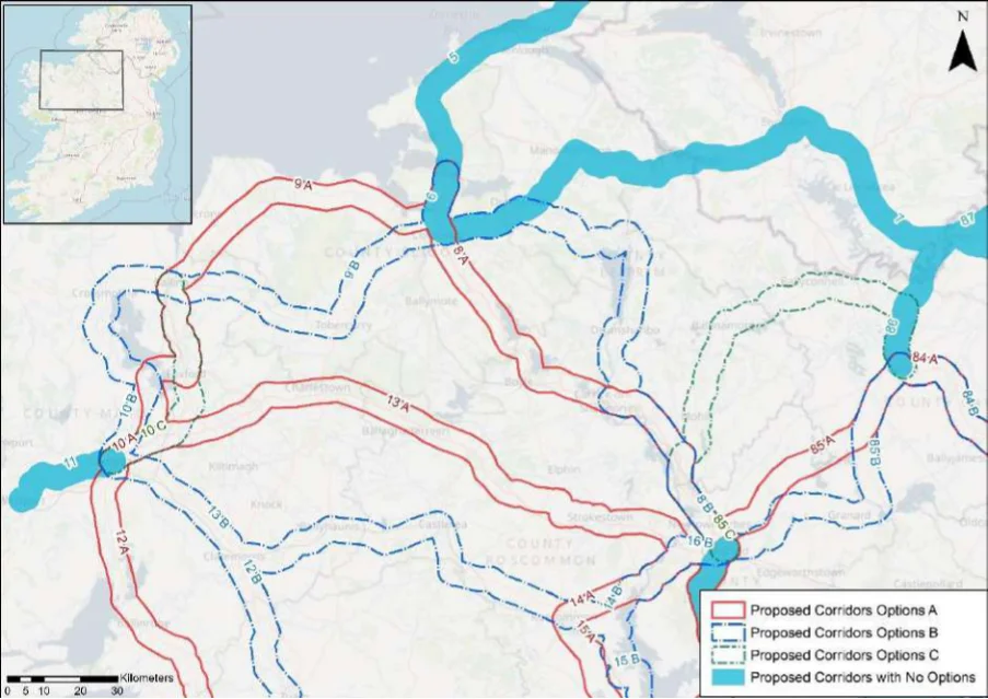
Table 6. Appraisal Relating to Corridor 6 Sligo to Enniskillen
Figure B2: Map of corridor options 6, 7 and 8
SEA Theme Summary of the Potential Effects Associated with Corridor 6 Sligo to Enniskillen
Within the corridor there are approximately 8 SAC, 1 SPA, and 13 pNHA/NHA, including for Biodiversity example Ballysadare Bay SAC, SPA, and pNHA, Unshin River SAC and pNHA, Boleybrack Mountain SAC and pNHA, and Dough/Thur Mountains NHA. These designated sites and key sensitivities associated with the designations would need to be considered when determining the final route during scheme development. Land take requirements are not known at this stage; however, it is anticipated the route would utilise existing infrastructure where practicable, such as existing roads.
Population and Human Health
The corridor would link Sligo (population c.19,250) with Enniskillen (population c.13,650) via Manorhamilton (population c.1,475), supporting accessibility to the services, facilities and amenities available in these settlements. In this respect an enhancement of accessibility by active travel modes will promote social inclusion and the quality of life of residents and support health and wellbeing. The corridor also has the potential to bring benefits for the visitor economy along the route and support community vitality.
Land use along the proposed corridor / within the area varies and includes areas of urban fabric Land and Soils (artificial surfaces), road and rail network (artificial surfaces) in Enniskillen, Manorhamilton and Sligo town, and area of pastures (agricultural areas), peat bogs (wetland), land principally occupied by agriculture with significant areas of natural vegetation (agricultural areas), coniferous forests (forest and semi-natural areas), transitional woodland-shrub (forest and seminatural areas), mixed forest (forest and semi-natural areas) as per CORINE 2018. Should the route primarily involve the reallocation of road space, loss of land and loss of productive agricultural land is unlikely to be significant. Should the route require land-take from (agriculture) land, the impact to likely to be significant / uncertain.
Several watercourses occur along the route of the proposed corridor, including the Ballysadare Water River, Killanummery River, Bonet River, Drumharriff Burn River and the Sillees River and Ballysadare Estuary. The WFD status of these watercourses ranged between ‘good’ and ‘poor’ during the 2013-2018 monitoring period. The watercourses within the proposed corridor ranged from ‘at risk’ to ‘under review’.
The route occurs in an area considered to be of ‘Good’ air quality. The route will provide a safe Air Quality cycle route between Enniskillen and Sligo. This will promote a modal shift to active modes of travel which will in turn support ongoing improvements to air quality in the area.
Appendix B: Corridor option assessment tables
National Cycle Network SEA Environmental Report (Updated)
SEA Theme Summary of the Potential Effects Associated with Corridor 6 Sligo to Enniskillen Impact
The development of the corridor as part of the NCN would promote a shift to active modes of Climate Change travel from higher emission modes, including the private car. This will support a limitation of greenhouse gas emissions from transport. The corridor may cross (and potentially negatively/positively impact on) areas of flood risk. Whilst impacts on flood risk, and, more broadly, climate change adaptation, depends on the detailed route of the corridor and scheme design, there would be a need to ensure that the delivery of the corridor supports the resilience of the local area to the potential effects of climate change.
Positive
A range of cultural heritage assets are present within the proposed corridor, such as a cathedral Cultural Heritage (Reg. No. 32012002), outbuilding (Reg. No. 32011012), ringfort (SL020-069----), ringfort (SL020-211----), ringfort (LE014-017----) and a railway station (Reg. No. 30805033). Given part of the proposed corridor is located along a historic railway line, sensitive development of the corridor as a cycle route offers the potential for the rejuvenation and enhanced enjoyment of this heritage asset. However, the proposed corridor also has the potential to impact on the setting of other cultural heritage assets (e.g., archaeological remains) which may occur along the proposed corridor.
Uncertain
The proposed corridor, given it is likely to follow existing transport infrastructure, is unlikely to Landscape lead to significant impacts on landscape character. It also offers opportunities to enhance the quality of the public realm, if high quality design and layouts are integrated within subsequent schemes. More broadly, the implementation of the corridor will support active travel modes, which are modes of transport with limited impacts on landscape character. Through promoting active travel modes, the corridor also offers opportunities to support an enhanced understanding and enjoyment of the special qualities and intrinsic character of the landscape in the vicinity of the corridor.
Positive
Appendix B: Corridor option assessment tables AECOM
National Cycle Network
Table 7. Appraisal Relating to Corridor 7 Enniskillen to Cavan
SEA Theme Summary of the Potential Effects Associated with Corridor 7 Enniskillen to Cavan
| Biodiversity Within the corridor there are two SACs, two SPAs, and two pNHA/NHAs, including Lough Oughter and associated Loughs SAC and pNHA, Upper Lough Erne SAC, Slieve Beagh- Mullaghfad-Lisnaskea SPA, and Drumkeen House Woodland pNHA. These designated sites and key sensitivities associated with the designations would need to be considered when determining the final route during scheme development. Land take requirements are not known at this stage; however it is anticipated the route would utilise existing infrastructure where practicable, such as along existing roads. | Uncertain |
|---|---|
| Population and The corridor would link Cavan (population c.10,900) with Enniskillen (population c.13,650) Human Health via Clones (population c.1,680), supporting accessibility to the services, facilities and amenities available in these settlements. In this respect an enhancement of accessibility by active travel modes will promote social inclusion and the quality of life of residents and support health and wellbeing. The corridor also has the potential to bring benefits for the visitor economy along the route and support community vitality. | Positive |
| Land and Soils Land use along the proposed corridor / within the area varies and includes urban fabric (artificial surfaces) in Enniskillen, Clones and Cavan town and areas of pastures (agricultural areas), forest (broad-leafed), forest and semi natural areas (forest and semi-natural areas) as per CORINE 2018. Should the route primarily involve the reallocation of road space, loss of land and loss of productive agricultural land is unlikely to be significant. Should the route require some land-take (from agriculture), the impact to likely to be significant / uncertain. | Uncertain |
| Water Several watercourses occur along the route of the proposed corridor, including the Upper Lough Erne River, Colebrooke River, River Finn and the River Annalee. The WFD status of these watercourses ranged between ‘good’ and ‘poor’ during the 2013-2018 monitoring period. | Uncertain |
| Air Quality The route occurs in an area considered to be of ‘Good’ air quality. The route will provide a safe cycle route between Enniskillen and Cavan town. This will promote a modal shift to active modes of travel which will in turn support ongoing improvements to air quality in the area. | Positive |
| Climate Change The development of the corridor as part of the NCN would promote a shift to active modes of travel from higher emission modes, including the private car. This will support a limitation of greenhouse gas emissions from transport. The corridor may cross (and potentially negatively/positively impact on) areas of flood risk. Whilst impacts on flood risk, and, more broadly, climate change adaptation, depends on the detailed route of the corridor and scheme design, there would be a need to ensure that the delivery of the corridor supports the resilience of the local area to the potential effects of climate change. | Positive |
| Cultural Heritage A range of cultural heritage assets are present within the proposed corridor, such as a bridge (Reg. No. 41401616), bridge (Reg. No. 41401625) and outbuilding (Reg. No. 40000450). The development of the cycle corridor offers the potential for the rejuvenation and enhanced enjoyment of cultural heritage assets. However, the proposed corridor also has the potential to impact on the setting of archaeological assets which occur along the proposed corridor. | Uncertain |
| Landscape The proposed corridor, given it is likely to follow existing transport infrastructure, is unlikely to lead to significant impacts on landscape character. It also offers opportunities to enhance the quality of the public realm, if high quality design and layouts are integrated within subsequent schemes. More broadly, the implementation of the corridor will support active travel modes, which are modes of transport with limited impacts on landscape character. Through promoting active travel modes, the corridor also offers opportunities to support an enhanced understanding and enjoyment of the special qualities and intrinsic character of the landscape in the vicinity of the corridor. | Positive |
Appendix B: Corridor option assessment tables
National Cycle Network
Table 8. Appraisal Relating to Corridor 8 Longford to Sligo
| SEA Theme Summary of the Potential Effects Associated with Corridor 8 Longford to Sligo A | B | |
|---|---|---|
| Biodiversity Option A: In the vicinity of the corridor there are approximately eight SACs, three SPAs, and 24 pNHA/NHAs, including for example Ballykenny-Fisherstown Bog SPA, Lough Forbes Complex SAC and pNHA, Lough Arrow SAC, SPA and pNHA, Bricklieve Mountains and Keishcorran SAC and pNHA, and Ballysadare Bay SAC, SPA and pNHA. These designated sites and key sensitivities associated with the designations would need to be considered when determining the final route during scheme development. Land take requirements are not known at this stage; however, it is anticipated the route would utilise existing infrastructure where practicable, such as along existing roads where practicable. Option B: In the vicinity of the corridor are approximately eight SACs, two SPAs, and 24 pNHA/NHAs, including for example Ballykenny-Fisherstown Bog SPA, Lough Forbes Complex SAC and pNHA, Drumhierny Wood pNHA, Lough Allen, South End and Parts pNHA, Cuilcagh - Anierin Uplands SAC and pNHA, and Ballysadare Bay SAC, SPA and pNHA. These designated sites and key sensitivities associated with the designations would need to be considered when determining the final route during scheme development. Land take requirements are not known at this stage; however, it is anticipated the route would utilise existing infrastructure where practicable. | = | = |
| Population The corridor options would link Longford (population c.10,010) with Sligo (population c.19,250) and Human via Carrick-on-Shannon (population c.4,060). Option A will additionally provide linkages to Boyle Health (population c.2,570), Collooney (population c.1,610) and Ballisodare (population c.1,350). The corridor options will support accessibility to the services, facilities and amenities available in these settlements. In this respect an enhancement of accessibility by active travel modes will promote social inclusion and the quality of life of residents and support health and wellbeing. The corridor also has the potential to bring benefits for the visitor economy along the route and support community vitality. Option A, through linking additional settlements, will however bring additional benefits in relation to this SEA theme. | 1 | 2 |
| Land and Soils Option A: Land use along the proposed corridor / within the area is varies and includes urban fabric (artificial surfaces) in Sligo town, Carrick-on-Shannon and Longford town and areas of pastures (agricultural areas), peat bogs (wetland) and forests (forest and semi-natural areas) as per CORINE 2018. Should the route primarily involve the reallocation of road space, loss of land and loss of productive agricultural land is unlikely to be significant. Option B: Land use along the proposed corridor / within the area is variable and includes urban fabric (artificial surfaces) in Sligo town, Drumshanbo, Carrick-on-Shannon and Longford town and areas of pastures (agricultural areas), peat bogs (wetland) and forests (forest and semi- natural areas) as per CORINE 2018. Should the route primarily involve the reallocation of road space, loss of land and loss of productive agricultural land is unlikely to be significant. Should the route require some land-take (from agriculture), the impact to likely to be significant / uncertain. Option A is likely to perform more favourably in relation to this SEA theme as it aligns more along existing road infrastructure and would require less land-take (from agriculture). | 1 | 2 |
| Water Option A: Several watercourses occur along the route of the proposed corridor, including the Ballysodare River, Unshin River, Drumfin River, Boyle River and the River Shannon. The WFD status of these watercourses ranges between ‘good’ and ‘poor’ during the 2013-2018 monitoring period. The watercourses within the proposed corridor ranges from ‘at risk’ to ‘under review’. Option B: Several watercourses occur along the route of the proposed corridor, including the Unshin River, Owengar River, River Shannon, Drumshanbo stream, Lough Allen Canel, River Eslin and River Camlin. The WFD status of these watercourses ranges between ‘good’ and ‘poor’ during the 2013-2018 monitoring period. The watercourses within the proposed corridor ranges from ‘at risk’ to ‘under review’. | = | = |
| Air Quality Options A & B: The route occurs in an area considered to be of ‘Good’ air quality. The route will provide a safe cycle route between Sligo town and Longford town. This will promote a modal shift to active modes of travel which will in turn support ongoing improvements to air quality in the area. | = | = |
| Climate The development of the corridor options as part of the NCN would promote a shift to active Change modes of travel from higher emission modes, including the private car. This will support a limitation of greenhouse gas emissions from transport. Option A, through linking additional settlements, will however bring additional benefits in relation to this element of climate change mitigation. The corridor options may cross (and potentially negatively/positively impact on) areas of flood risk. Whilst impacts on flood risk, and, more broadly, climate change adaptation, depends on the detailed route of the corridor and scheme design, there would be a need to ensure that the delivery of the corridor options supports the resilience of the local area to the potential effects of climate change. | 1 | 2 |
Appendix B: Corridor option assessment tables
National Cycle Network SEA Environmental Report (Updated)
| Option A | B |
|---|---|
| = | = |
| = | = |
SEA Theme Summary of the Potential Effects Associated with Corridor 8 Longford to Sligo
Cultural Heritage
Option A: A range of cultural heritage assets are present within the proposed corridor, such as a manse (Reg. No. 32011011), house (Reg. No. 32309007), ringfort (SL034-187----), field system (RO006-195----), ringfort (RO006-097----) and house (Reg. No. 13008007). The development of the cycle corridor offers the potential for the rejuvenation and enhanced enjoyment of cultural heritage assets. However, the proposed corridor also has the potential to impact on the setting of archaeological assets which occur along the proposed corridor. Option B: A range of cultural heritage assets are present within the proposed corridor, such as a ringfort (SL020-211----), Ringfort (LE014-017----), house (Reg. No. 3080700), ringfort (LE020- 006----), ringfort (LE031-051----) and a bridge (LF013-026004-). The development of the cycle corridor offers the potential for the rejuvenation and enhanced enjoyment of cultural heritage assets. However, the proposed corridor also has the potential to impact on the setting of archaeological assets which occur along the proposed corridor.
The corridor options, given they largely follow existing transport corridors, are unlikely to lead Landscape to significant impacts on landscape character. They also offer opportunities to enhance the quality of the public realm, if high quality design and layouts are integrated within subsequent schemes. More broadly, the corridor options will support active travel modes, which are modes of transport with limited impacts on landscape character. Through promoting active travel modes, the corridor options will also support an enhanced understanding and enjoyment of the special qualities and intrinsic character of the landscape.
Appendix B: Corridor option assessment tables AECOM
National Cycle Network
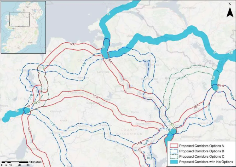
Table 9. Appraisal Relating to Corridor 9 Sligo to Ballina
Figure B3: Map of corridor options 9, 10 and 11
| Option A | B |
|---|---|
| 1 | 2 |
| 2 | 1 |
| 2 | 1 |
SEA Theme Summary of the Potential Effects Associated with Corridor 9 Sligo to Ballina
Option A: In the vicinity of the corridor are approximately eight SACs, two SPAs, and seven Biodiversity pNHA/NHAs, including for example Cummeen Strand/Drumcliff Bay (Sligo Bay) SAC and pNHA, Lough Gill SAC and pNHA, Ballysadare Bay SAC, SPA and pNHA, and Killala Bay/Moy Estuary SAC, SPA and pNHA. Option A is located further away from designated sites. These designated sites and key sensitivities associated with the designations would need to be considered when determining the final route during scheme development. Land take requirements are not known at this stage; however it is anticipated the route would utilise existing infrastructure where practicable. Option B: In the vicinity of the corridor are approximately ten SACs, two SPAs, and eight pNHA/NHAs, including for example Cummeen Strand/Drumcliff Bay (Sligo Bay) SAC and pNHA, Ballysadare Bay SAC, SPA and pNHA, Ox Mountains Bogs SAC and pNHA, Lough Nabrickkeagh Bog pNHA, Killala Bay/Moy Estuary SAC, SPA and pNHA, and River Moy SAC. These designated sites and key sensitivities associated with the designations would need to be considered further when determining the final route during scheme development. Land take requirements are not known at this stage; however it is anticipated the route would utilise existing infrastructure where practicable such as along existing road and cycleway infrastructure where it occurs.
Population and Human Health
The options would link Sligo (population 19,250) with Ballina (population c.10,170), supporting accessibility to the services, facilities and amenities available in these settlements. In this respect an enhancement of accessibility by active travel modes will promote social inclusion and the quality of life of residents and support health and wellbeing. The corridor also has the potential to bring benefits for the visitor economy along the route and support community vitality. Option B will however also link Sligo and Ballina with Tubbercurry (population c.1,990), bringing additional benefits in relation to this SEA theme.
Land and Soils Option A: Land use along the proposed corridor / within the area varies and includes urban
fabric (artificial surfaces) in Sligo town, Ballysdare, Dromore West and Ballina and areas of pastures (agricultural areas), non-irrigated arable land (agricultural areas) and peat bogs (wetland) and forests (forest and semi-natural areas) as per CORINE 2018. Should the route primarily involve the reallocation of road space, loss of land and loss of productive agricultural land is unlikely to be significant.
Appendix B: Corridor option assessment tables
National Cycle Network SEA Environmental Report (Updated)
Option
| SEA Theme Summary of the Potential Effects Associated with Corridor 9 Sligo to Ballina A | B | |
|---|---|---|
| Option B: Land use along the proposed corridor / within the area is variable and includes urban fabric (artificial surfaces) in Sligo town, Tubbercurry and Ballina and areas of pastures (agricultural areas), non-irrigated arable land (agricultural areas) and peat bogs (wetland) and forests (forest and semi-natural areas) as per CORINE 2018. Should the route primarily involve the reallocation of road space, loss of land and loss of productive agricultural land is unlikely to be significant. Should the route primarily involve the reallocation of road space / recreational amenity infrastructure, loss of land and loss of productive agricultural land is unlikely to be significant. Option B is the preferred option for land and soils, as it aligns more along existing infrastructure (greenway) and would require less land-take (from agriculture). | ||
| Water Option A: Several watercourses occur along the route of the proposed corridor, including Knocknahur River, Barnabrack River, Easky River and the River Brusna and Moy Estuary and Ballysadare Estuary. The WFD status of these watercourses ranges between ‘good’ and ‘poor’ during the 2013-2018 monitoring period. The watercourses within the proposed corridor ranges from ‘at risk’ to ‘under review’. Option B: Several watercourses occur along the route of the proposed corridor, including Knocknahur River, Owenbeg River, Tubbercurry River, Behy River and the River Brusna and Ballysadare Estuary. The WFD status of these watercourses ranges between ‘good’ and ‘poor’ during the 2013-2018 monitoring period. The watercourses within the proposed corridor ranges from ‘at risk’ to ‘under review’. | = | = |
| Air Quality Options A & B: The route occurs in an area considered to be of ‘Good’ air quality. The route will provide a safe cycle route between Sligo town and Ballina. This will promote a modal shift to active modes of travel which will in turn support ongoing improvements to air quality in the area. | = | = |
| Climate The development of the corridor options as part of the NCN would promote a shift to active Change modes of travel from higher emission modes, including the private car. This will support a limitation of greenhouse gas emissions from transport. Option B, through linking additional settlements, will however bring additional benefits in relation to this element of climate change mitigation. The corridor options may cross (and potentially negatively/positively impact on) areas of flood risk. Whilst impacts on flood risk, and, more broadly, climate change adaptation, depends on the detailed route of the corridor and scheme design, there would be a need to ensure that the delivery of the corridor options supports the resilience of the local area to the potential effects of climate change. | 2 | 1 |
| Cultural Option A: A range of cultural heritage assets are present within the proposed corridor, such as Heritage a house (Reg. No. 32309007), Monumental structure (SL019-006002-), enclosure (SL018-030- ---), Fulacht fia (MA030-106----) and the quay / wharf (Reg. No. 31204106). The development of the cycle corridor offers the potential for the rejuvenation and enhanced enjoyment of cultural heritage assets. However, the proposed corridor also has the potential to impact on the setting of archaeological assets which occur along the proposed corridor. Option B: A range of cultural heritage assets are present within the proposed corridor, such as a battlefield (SL020-281----), railway station (Reg. No. 32312004), Railway Station (Reg. No. 32316016) and Upper Bridge (Reg. No. 31204104). Given part of the proposed corridor is located along a historic railway line, sensitive development of the corridor as a cycle route offers the potential for the rejuvenation and enhanced enjoyment of this heritage asset. However, the proposed corridor also has the potential to impact on the setting of other cultural heritage assets (e.g., archaeological remains) which may occur along the proposed corridor. Option B is the preferred option for cultural heritage, as it aligns along existing infrastructure (greenway) and would rejuvenation and connect these cultural heritage assets. | 2 | 1 |
| Landscape The corridor options, given they largely follow existing transport corridors, are unlikely to lead to significant impacts on landscape character. They also offer opportunities to enhance the quality of the public realm, if high quality design and layouts are integrated within subsequent schemes. More broadly, the corridor options will support active travel modes, which are modes of transport with limited impacts on landscape character. Through promoting active travel modes, the corridor options will also support an enhanced understanding and enjoyment of the special qualities and intrinsic character of the landscape. | = | = |
Appendix B: Corridor option assessment tables AECOM
National Cycle Network
Table 10. Appraisal Relating to Corridor 10 Ballina to Castlebar
SEA Theme Summary of the Potential Effects Associated with Corridor 10 Ballina to Castlebar
| Biodiversity Option A: The corridor passes through Lough Conn and Lough Cullin SPA and pNHA and the River Moy SAC. The route also passes through the Moy Valley pNHA. These designated sites and key sensitivities associated with the designations would need to be considered further when determining the final route during scheme development. Land take requirements are not known at this stage; however, it is anticipated the route would utilise existing infrastructure where practicable. Option B: The corridor encompasses River Moy SAC, Lough Conn and Lough Cullin SPA and pNHA, and Cunnagher More Bog NHA. These designated sites and key sensitivities associated with the designations would need to be considered further when determining the final route during scheme development. Land take requirements are not known at this stage; however, it is anticipated the route would utilise existing infrastructure where practicable. Option C: The corridor passes through or encompasses River Moy SAC, Killala Bay/Moy Estuary SAC and pNHA, Moy Valley pNHA. These designated sites and key sensitivities associated with the designations would need to be considered further when determining the final route during scheme development. Land take requirements are not known at this stage; however, it is anticipated the route would utilise existing infrastructure where practicable such as along existing road and cycleway/greenway infrastructure. | = | = | = |
|---|---|---|---|
| Population Options A, B & C link Ballina (population c.10,170) and Castlebar (population c. 12,070), and Human supporting accessibility to the services and facilities available in these settlements. Due to the Health broad routes of the options, Options A & C would also enhance accessibility from Foxford (population c.1,315), and Option B would enhance accessibility from Crossmolina (population c.1,044). An enhancement of accessibility by active travel modes will promote social inclusion and the quality of life of residents and support health and wellbeing. All three corridors also have the potential to bring benefits for the visitor economy along the routes and support community vitality. | = | = | = |
| Land and Option A: Land use along the proposed corridor / within the area varies and includes urban Soils fabric (artificial surfaces) in Ballina, Foxford and Castlebar and areas of pastures (agricultural areas), land principally occupied by agriculture with significant areas of natural vegetation (agricultural areas), peat bogs (wetland), coniferous forests (forest and semi-natural areas), wetland (inland marshes), forest and semi-natural areas (forest and semi-natural areas), forest (broad-leafed) as per CORINE 2018. Should the route primarily involve the reallocation of road space / historic railway, loss of land and loss of productive agricultural land is unlikely to be significant. Option B: Land use along the proposed corridor / within the area is variable and includes urban fabric (artificial surfaces) in Ballina, Pootoon and Castlebar and areas of pastures (agricultural areas), land principally occupied by agriculture with significant areas of natural vegetation (agricultural areas), peat bogs (wetland), coniferous forests (forest and semi-natural areas), wetland (inland marshes), forest and semi-natural areas (forest and semi-natural areas), forest (broad-leafed) as per CORINE 2018. Should the route primarily involve the reallocation of road space / historic railway, loss of land and loss of productive agricultural land is unlikely to be significant. Option C: Land use along the proposed corridor / within the area is variable and includes urban fabric (artificial surfaces) in Ballina and Castlebar and areas of pastures (agricultural areas), land principally occupied by agriculture with significant areas of natural vegetation (agricultural areas), peat bogs (wetland), coniferous forests (forest and semi-natural areas), wetland (inland marshes), forest and semi-natural areas (forest and semi-natural areas), forest (broad-leafed) as per CORINE 2018. Should the route primarily involve the reallocation of road space, loss of land and loss of productive agricultural land is unlikely to be significant. | = | = | = |
| Water Option A: Several watercourses occur along the route of the proposed corridor, including the River Moy, River Crumlin and the Castlebar River and Lough Conn. The WFD status of these watercourses ranges between ‘good’ and ‘poor’ during the 2013-2018 monitoring period. The watercourses within the proposed corridor ranges from ‘at risk’ to ‘under review’. Option B: Several watercourses occur along the route of the proposed corridor, including the River Moy, River Deel, River Crumlin and the Castlebar River and Lough Conn. The WFD status of these watercourses ranges between ‘good’ and ‘poor’ during the 2013-2018 monitoring period. The watercourses within the proposed corridor ranges from ‘at risk’ to ‘under review’. Option C: Several watercourses occur along the route of the proposed corridor, including the River Moy, River Crumlin and the Castlebar River. The WFD status of these watercourses ranges between ‘good’ and ‘poor’ during the 2013-2018 monitoring period. The watercourses within the proposed corridor ranges from ‘at risk’ to ‘under review’. | = | = | = |
Appendix B: Corridor option assessment tables
National Cycle Network SEA Environmental Report (Updated)
Option
SEA Theme Summary of the Potential Effects Associated with Corridor 10 Ballina to Castlebar A B C
| Air Quality Options A & B & C: The route occurs in an area considered to be of ‘Good’ air quality. The route will provide a safe cycle route between Ballina and Castlebar and passes through Foxford, Pontoon and Turlough. This will promote a modal shift to active modes of travel which will in turn support ongoing improvements to air quality in the area. | = | = | = |
|---|---|---|---|
| Climate The development of the corridor options as part of the NCN would promote a shift to active Change modes of travel from higher emission modes, including the private car. This will support a limitation of greenhouse gas emissions from transport. The corridor options may cross (and potentially negatively/positively impact on) areas of flood risk. Whilst impacts on flood risk, and, more broadly, climate change adaptation, depends on the detailed route of the corridor and scheme design, there would be a need to ensure that the delivery of the corridor options supports the resilience of the local area to the potential effects of climate change. | = | = | = |
| Cultural Option A: A range of cultural heritage assets are present within the proposed corridor, such Heritage as an enclosure (MA039-080----), barracks (MA060-035002-), bridge (Reg. No. 31206002), mill (Reg. No. 31307004), ritual site / holy well (MA078-006002-), and gates / railings / walls (Reg. No. 31209074). Given part of the proposed corridor is located along a historic railway line, sensitive development of the corridor as a cycle route offers the potential for the rejuvenation and enhanced enjoyment of this heritage asset. However, the proposed corridor also has the potential to impact on the setting of other cultural heritage assets (e.g., archaeological remains) which may occur along the proposed corridor. Option B: A range of cultural heritage assets are present within the proposed corridor, such as an enclosure (MA030-050----), church (MA038-061001-), gates / railings / walls (Reg. No. 31304704), building (Reg. No. 31306003) and a bridge (Reg. No. 31306905). Given part of the proposed corridor is located along a historic railway line, sensitive development of the corridor as a cycle route offers the potential for the rejuvenation and enhanced enjoyment of this heritage asset. However, the proposed corridor also has the potential to impact on the setting of other cultural heritage assets (e.g., archaeological remains) which may occur along the proposed corridor. Option C: A range of cultural heritage assets are present within the proposed corridor, such as a water pump (Reg. No. 31204097, enclosure (MA039-080----), settlement deserted – medieval (MA060-036001-), enclosure (MA060-048----), bridge (Reg. No. 31307030) and a castle (MA070-183----). The development of the cycle corridor offers the potential for the rejuvenation and enhanced enjoyment of cultural heritage assets. However, the proposed corridor also has the potential to impact on the setting of archaeological assets which occur along the proposed corridor. | = | = | = |
| Landscape The corridor options, given they largely follow existing transport corridors, are unlikely to lead to significant impacts on landscape character. They also offer opportunities to enhance the quality of the public realm, if high quality design and layouts are integrated within subsequent schemes. More broadly, the corridor options will support active travel modes, which are modes of transport with limited impacts on landscape character. Through promoting active travel modes, the corridor options will also support an enhanced understanding and enjoyment of the special qualities and intrinsic character of the landscape. | = | = | = |
Appendix B: Corridor option assessment tables AECOM
National Cycle Network
Table 11. Appraisal Relating to Corridor 11 Westport to Castlebar
SEA Theme Summary of the Potential Effects Associated with Corridor 11 Westport to Castlebar
| Biodiversity The corridor is adjacent to the Dambaduff Lough pNHA near Kilfea, the Clew Bay Complex SAC and pNHA is also located within the surrounding environs of the corridor. These designated sites and key sensitivities associated with the designations would need to be considered further when determining the final route during scheme development. Land take requirements are not known at this stage; however it is anticipated the route would utilise existing infrastructure where practicable, such as along existing roads infrastructure. | Uncertain |
|---|---|
| Population and The corridor would link Castlebar (population c.12,070) with Westport (population c.6,200), Human Health supporting accessibility to the services, facilities and amenities available in these settlements. In this respect an enhancement of accessibility by active travel modes will promote social inclusion and the quality of life of residents and support health and wellbeing. The corridor also has the potential to bring benefits for the visitor economy along the route and support community vitality. | Positive |
| Land and Soils Land use along the proposed corridor / within the area varies and includes areas of urban fabric (artificial surfaces) and sport and leisure facilities (artificial surfaces) in Castlebar and Westport and areas of land principally occupied by agriculture with significant areas of natural vegetation (agricultural areas) and pastures (agricultural areas) as per CORINE 2018. Should the route primarily involve the reallocation of road space, loss of land and loss of productive agricultural land is unlikely to be significant. | Uncertain |
| Water Several watercourses occur along the route of the proposed corridor, including the Castlebar River and the Moyour River and Westport Bay. The WFD status of these watercourses ranges between ‘good’ and ‘poor’ during the 2013-2018 monitoring period. The watercourses within the proposed corridor ranges from ‘at risk’ to ‘under review’. | Uncertain |
| Air Quality The route occurs in an area considered to be of ‘Good’ air quality. The route will provide a safe cycle route between Castlebar and Westport. This will promote a modal shift to active modes of travel which will in turn support ongoing improvements to air quality in the area. | Positive |
| Climate Change The development of the corridor as part of the NCN would promote a shift to active modes of travel from higher emission modes, including the private car. This will support a limitation of greenhouse gas emissions from transport. The corridor may cross (and potentially negatively/positively impact on) areas of flood risk. Whilst impacts on flood risk, and, more broadly, climate change adaptation, depends on the detailed route of the corridor and scheme design, there would be a need to ensure that the delivery of the corridor supports the resilience of the local area to the potential effects of climate change. | Positive |
| Cultural Heritage A range of cultural heritage assets are present within the proposed corridor, such as a Windmill (MA078-010----), enclosure (MA077-020----) and a house (Reg. No. 31212038). The development of the cycle corridor offers the potential for the rejuvenation and enhanced enjoyment of cultural heritage assets. However, the proposed corridor also has the potential to impact on the setting of archaeological assets which occur along the proposed corridor. | Uncertain |
| Landscape The proposed corridor, given it is likely to follow existing transport infrastructure, is unlikely to lead to significant impacts on landscape character. It also offers opportunities to enhance the quality of the public realm, if high quality design and layouts are integrated within subsequent schemes. More broadly, the implementation of the corridor will support active travel modes, which are modes of transport with limited impacts on landscape character. Through promoting active travel modes, the corridor also offers opportunities to support an enhanced understanding and enjoyment of the special qualities and intrinsic character of the landscape in the vicinity of the corridor. | Positive |
Appendix B: Corridor option assessment tables
National Cycle Network
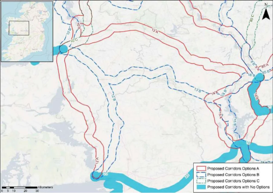
Table 12. Appraisal Relating to Corridor 12 Galway to Castlebar
Figure B4: Map of corridor options 12, 13, 14 and 15
| Option A | B |
|---|---|
| 1 | 2 |
| 1 | 2 |
SEA Theme Summary of the Potential Effects Associated with Corridor 12 Galway to Castlebar
Option A: In the vicinity of the corridor are approximately six SACs, two SPAs, and eight Biodiversity pNHA/NHA, including for example Lough Corrib SAC, SPA and pNHA, Shrule Turlough SAC and pNHA, Mocorha Lough SAC and pNHA, Lough Carra/Mask Complex SAC and pNHA, and Lough Mask SPA. These designated sites and key sensitivities associated with the designations would need to be considered further when determining the final route during scheme development. Land take requirements are not known at this stage; however it is anticipated the route would utilise existing infrastructure where practicable. Option B: The corridor traverses Lough Corrib SAC and pNHA, River Moy SAC, Carrowmore Lough Shore pNHA, Altore Lake pNHA, and Kiltullagh Turlough pNHA. These designated sites and key sensitivities associated with the designations would need to be considered further when determining the final route during scheme development. Land take requirements are not known at this stage; however it is anticipated the route would utilise existing infrastructure where practicable.
Population and Human Health
The corridor options would link Castlebar (population c.12,070) with the city of Galway (population c.80,000). Due to the broad routes of the options, Option A would enhance accessibility from Ballinrobe (population c.2,790), and Option B would enhance accessibility from the larger settlement of Tuam (population c. 8,770). In this respect both options would support an enhancement of accessibility by active travel modes, promoting social inclusion and the quality of life of residents and supporting health and wellbeing. The options also have the potential to bring benefits for the visitor economy along the routes and support community vitality. Option B however has the potential to bring additional benefits through linking the larger settlement of Tuam.
Appendix B: Corridor option assessment tables
National Cycle Network SEA Environmental Report (Updated)
Option
SEA Theme Summary of the Potential Effects Associated with Corridor 12 Galway to Castlebar A B
| Land and Option A: Land use along the proposed corridor / within the area varies and includes urban fabric Soils (artificial surfaces) in Castlebar, Headford and Galway City and areas of pastures (agricultural areas), non-irrigated arable land (agricultural areas), peat bogs (wetland), forests (forest and semi- natural areas), mineral extraction sites and wetlands (inland marshes) as per CORINE 2018. Should the route primarily involve the reallocation of road space, loss of land and loss of productive agricultural land is unlikely to be significant. Option B: Land use along the proposed corridor / within the area is variable and includes urban fabric (artificial surfaces) in Castlebar, Claremorris, Tuam, Claregalway and Galway City and areas of pastures (agricultural areas), non-irrigated arable land (agricultural areas), peat bogs (wetland), forests (forest and semi-natural areas) and wetlands (inland marshes) as per CORINE 2018. Should the route primarily involve the reallocation of road space / railway, loss of land and loss of productive agricultural land is unlikely to be significant. Option B is the preferred option for land and soils, as it aligns more along existing infrastructure (greenway) and would require less land-take (from agriculture). | 2 | 1 |
|---|---|---|
| Water Option A: Several watercourses occur along the route of the proposed corridor, including the Castlebar River, Claureen River, Robe River, Gregg River and the River Clare. The WFD status of these watercourses ranges between ‘good’ and ‘poor’ during the 2013-2018 monitoring period. The watercourses within the proposed corridor ranges from ‘at risk’ to ‘under review’. Option B: Several watercourses occur along the route of the proposed corridor, including the Robe River and River Clare (Galway). The WFD status of these watercourses ranges between ‘good’ and ‘poor’ during the 2013-2018 monitoring period. The watercourses within the proposed corridor ranges from ‘at risk’ to ‘under review’. | = | = |
| Air Quality Options A & B: The route occurs in an area considered to be of ‘Good’ air quality. The route will provide a safe cycle route between Castlebar and Galway City. This will promote a modal shift to active modes of travel which will in turn support ongoing improvements to air quality in the area. | = | = |
| Climate The development of the corridor options as part of the NCN would promote a shift to active modes Change of travel from higher emission modes, including the private car. This will support a limitation of greenhouse gas emissions from transport. Option A, through linking the larger settlement of Tuam, will however bring additional benefits in relation to this element of climate change mitigation. The corridor options may cross (and potentially negatively/positively impact on) areas of flood risk. Whilst impacts on flood risk, and, more broadly, climate change adaptation, depends on the detailed route of the corridor and scheme design, there would be a need to ensure that the delivery of the corridor options supports the resilience of the local area to the potential effects of climate change. | 1 | 2 |
| Cultural Option A: A range of cultural heritage assets are present within the proposed corridor, such as a Heritage ringfort (MA078-040----), handball ally (Reg. No. 31308915), ringfort (MA089-053----), thatch house (Reg. No. 30404214) and castle tower (GA082-002----). The development of the cycle corridor offers the potential for the rejuvenation and enhanced enjoyment of cultural heritage assets. However, the proposed corridor also has the potential to impact on the setting of archaeological assets which occur along the proposed corridor. Options B: A range of cultural heritage assets are present within the proposed corridor, such as a ringfort (MA078-031001-), Fulacht fia (MA079-109----), footbridge (Reg. No. 31214018), church (GA016-097----) and a ringfort (GA082-074----). Given part of the proposed corridor is located along a historic railway line, sensitive development of the corridor as a cycle route offers the potential for the rejuvenation and enhanced enjoyment of this heritage asset. However, the proposed corridor also has the potential to impact on the setting of other cultural heritage assets (e.g., archaeological remains) which may occur along the proposed corridor. Option B is the preferred option for cultural heritage, as it aligns along existing infrastructure (greenway) and would rejuvenation and connect these cultural heritage assets. | 2 | 1 |
| Landscape The corridor options, given they largely follow existing transport corridors, are unlikely to lead to significant impacts on landscape character. They also offer opportunities to enhance the quality of the public realm, if high quality design and layouts are integrated within subsequent schemes. More broadly, the corridor options will support active travel modes, which are modes of transport with limited impacts on landscape character. Through promoting active travel modes, the corridor options will also support an enhanced understanding and enjoyment of the special qualities and intrinsic character of the landscape. | = | = |
Appendix B: Corridor option assessment tables AECOM
National Cycle Network SEA Environmental Report (Updated)
Table 13. Appraisal Relating to Corridor 13 Castlebar to Longford (via N60)
SEA Theme Summary of the Potential Effects Associated with Corridor 13 Castlebar to Longford
| Biodiversity Option A: In the vicinity of the corridor are approximately eight SACs, three SPAs, and 15 pNHA/NHAs, including for example River Moy SAC, Tullaghanrock Bog SAC and pNHA, Cloonshanville Bog SAC and pNHA, Bellanagare Bog SAC, SPA and pNHA, Annaghmore Lough (Roscommon) SAC and pNHA, Ballykenny-Fisherstown Bog SPA, Lough Forbes Complex SAC and pNHA, and Brown Bog SAC pNHA. These designated sites and key sensitivities associated with the designations would need to be considered further when determining the final route during scheme development. Land take requirements are not known at this stage; however it is anticipated the route would utilise existing infrastructure where practicable such as along existing road and cycleways. Option B: Within the corridor there are approximately eight SACs, two SPAs, and 11 pNHA/NHA, including for example Carrowmore Lough Shore pNHA, Lough O’Flynn pNHA, Cloonchambers Bog SAC and pNHA, Lough Ree SAC, SPA and pNHA, Corbo Bog SAC and pNHA, Ballykenny- Fisherstown Bog SPA, Lough Forbes Complex SAC and pNHA, Brown Bog SAC and pNHA. These designated sites and key sensitivities associated with the designations would need to be considered further when determining the final route during scheme development. Land take requirements are not known at this stage; however it is anticipated the route would utilise existing infrastructure where practicable such as along existing road and cycleways. | = | = |
|---|---|---|
| Population The corridor options would link Castlebar (population c. 12,070) with Longford (population and Human c.10,000). Due to the broad routes of the options, Option A would enhance accessibility from Health Swinford (population c.1,400), Charlestown-Bellahy (population c.1,030) and Ballaghaderreen (population c. 1,810), and Option B would enhance accessibility from the settlements of Claremorris (population c. 3,690), Ballyhaunis (population c.2,370), Castlerea (population c.1,990), Roscommon (population c.5,880) and Lanesborough-Ballyleague (population c.1,450). In this respect both options would support an enhancement of accessibility by active travel modes, promoting social inclusion and the quality of life of residents and supporting health and wellbeing. The options also have the potential to bring benefits for the visitor economy along the routes and support community vitality. Option B however has the potential to bring additional benefits through linking a larger overall population. | 2 | 1 |
| Land and Option A: Land use along the proposed corridor / within the area varies and includes urban fabric Soils (artificial surfaces) in Castlebar, Swinford, Tulsk and Longford town and areas of pastures (agricultural areas), non-irrigated arable land (agricultural areas), peat bogs (wetland) and forests (forest and semi-natural areas) as per CORINE 2018. Should the route primarily involve the reallocation of road space, loss of land and loss of productive agricultural land is unlikely to be significant. Should the route require some land-take (from agriculture), the impact to likely to be significant / uncertain. Option B: Land use along the proposed corridor / within the area is variable and includes urban fabric (artificial surfaces) in Castlebar, Claremorris, Ballyhaunis, Roscommon town and Longford town and areas of pastures (agricultural areas), non-irrigated arable land (agricultural areas), peat bogs (wetland) and forests (forest and semi-natural areas) as per CORINE 2018. Should the route primarily involve the reallocation of road space, loss of land and loss of productive agricultural land is unlikely to be significant. Should the route require some land-take (from agriculture), the impact to likely to be significant / uncertain. | = | = |
| Water Option A: Several watercourses occur along the route of the proposed corridor, including the Castlebar River, Trimoge River, Swinford River, Lung River and the Feorish River. The WFD status of these watercourses ranges between ‘good’ and ‘poor’ during the 2013-2018 monitoring period. The watercourses within the proposed corridor ranges from ‘at risk’ to ‘under review’. Option B: Several watercourses occur along the route of the proposed corridor, including the Robe River, Suck River, Hind River and the River Shannon. The WFD status of these watercourses ranges between ‘good’ and ‘poor’ during the 2013-2018 monitoring period. The watercourses within the proposed corridor ranges from ‘at risk’ to ‘under review’. | = | = |
| Air Quality Options A & B: The route occurs in an area considered to be of ‘Good’ air quality. The route will provide a safe cycle route between Castlebar and Longford town. This will promote a modal shift to active modes of travel which will in turn support ongoing improvements to air quality in the area. | = | = |
| Climate The development of the corridor options as part of the NCN would promote a shift to active modes Change of travel from higher emission modes, including the private car. This will support a limitation of greenhouse gas emissions from transport. Option B, through linking a larger population, will however bring additional benefits in relation to this element of climate change mitigation. The corridor options may cross (and potentially negatively/positively impact on) areas of flood risk. Whilst impacts on flood risk, and, more broadly, climate change adaptation, depends on the detailed route of the corridor and scheme design, there would be a need to ensure that the delivery of the corridor options supports the resilience of the local area to the potential effects of climate change. | 2 | 1 |
Appendix B: Corridor option assessment tables
National Cycle Network SEA Environmental Report (Updated)
| Option A | B |
|---|---|
| = | = |
| = | = |
SEA Theme Summary of the Potential Effects Associated with Corridor 13 Castlebar to Longford
Option A: A range of cultural heritage assets are present within the proposed corridor, such as a house (Reg. No. 31307007), ringfort (MA070-157----), enclosure (MA071-075----) and a burnt mound MA063-064----) and a bridge (Reg. No. 13401301). The development of the cycle corridor offers the potential for the rejuvenation and enhanced enjoyment of cultural heritage assets. However, the proposed corridor also has the potential to impact on the setting of archaeological assets which occur along the proposed corridor. Options B: A range of cultural heritage assets are present within the proposed corridor, such as a souterrain (MA078-031002-), enclosure (MA079-087----), ringfort (MA102-033----), record (MA093- 055----), ritual site (MA103-010002-), burnt mound (RO025-033----), ringfort (RO034-026----0), Designed landscape – avenue (RO039-044----) and a bridge (RO037-005----). The development of the cycle corridor offers the potential for the rejuvenation and enhanced enjoyment of cultural heritage assets. However, the proposed corridor also has the potential to impact on the setting of archaeological assets which occur along the proposed corridor.
Cultural Heritage
The corridor options, given they largely follow existing transport corridors, are unlikely to lead to Landscape significant impacts on landscape character. They also offer opportunities to enhance the quality of the public realm, if high quality design and layouts are integrated within subsequent schemes. More broadly, the corridor options will support active travel modes, which are modes of transport with limited impacts on landscape character. Through promoting active travel modes, the corridor options will also support an enhanced understanding and enjoyment of the special qualities and intrinsic character of the landscape.
Appendix B: Corridor option assessment tables AECOM
National Cycle Network
Table 14. Appraisal Relating to Corridor 14 Roscommon to Longford
SEA Theme Summary of the Potential Effects Associated with Corridor 14 Roscommon to Longford
| Biodiversity Options A & B: Options A and B are located adjacent to Brown Bog SAC and pNHA, Ballykenny- Fisherstown Bog SPA, Lough Forbes Complex SAC and pNHA, Lough Bannow pNHA, Lough Ree SAC, SPA, and pNHA, and Lisnanarriagh Bog NHA. In addition Option A is located adjacent to Corbo Bog SAC and pNHA. Option B traverses Lough Ree SAC, SPA and pNHA, however it is partially located in an area with an existing cycling trail (Green Heartlands Cycle Route). Option A encroaches a section of Lough Ree SAC, SPA and pNHA but is located further away from the designated site than Option B. These designated sites and key sensitivities associated with the designations would need to be considered further when determining the final route during scheme development. Land take requirements are not known at this stage; however it is anticipated the route would utilise existing infrastructure where practicable such as along existing road and cycleways. | = | = |
|---|---|---|
| Population The corridor options would link Roscommon (population c.5,880) with Longford (population and Human c.10,000) supporting accessibility to the services, facilities and amenities available in these Health settlements. In this respect an enhancement of accessibility by active travel modes will promote social inclusion and the quality of life of residents and support health and wellbeing. The corridor options also have the potential to bring benefits for the visitor economy along the route and support community vitality. Given Option A would deliver a slightly shorter route between the two settlements, the option may bring additional benefits through enhanced useability. | 1 | 2 |
| Land and Soils Option A: Land use along the proposed corridor / within the area varies and includes urban fabric (artificial surfaces) in Roscommon town, Ballyleague and Longford town and areas of pastures (agricultural areas), inland marshes (wetland) and peat bogs (wetland) as per CORINE 2018. Should the route primarily involve the reallocation of road space, loss of land and loss of productive agricultural land is unlikely to be significant. Should the route require some land-take (from agriculture), the impact to likely to be significant / uncertain. Option B: Land use along the proposed corridor / within the area is variable and includes urban fabric (artificial surfaces) in Roscommon town, Ballyleague and Longford town and areas of pastures (agricultural areas), inland marshes (wetland) and peat bogs (wetland) as per CORINE 2018. Should the route primarily involve the reallocation of road space, loss of land and loss of productive agricultural land is unlikely to be significant. Should the route require some land-take (from agriculture), the impact to likely to be significant / uncertain. | = | = |
| Water Option A: Several watercourses occur along the route of the proposed corridor, including the Hind River, Clooneigh River, River Shannon and the Royal Canal. The WFD status of these watercourses ranges between ‘good’ and ‘poor’ during the 2013-2018 monitoring period. The watercourses within the proposed corridor ranges from ‘at risk’ to ‘under review’. Option B: Several watercourses occur along the route of the proposed corridor, including the Hind River and the River Shannon. The WFD status of these watercourses ranges between ‘good’ and ‘poor’ during the 2013-2018 monitoring period. The watercourses within the proposed corridor ranges from ‘at risk’ to ‘under review’. | = | = |
| Air Quality Options A & B: The route occurs in an area considered to be of ‘Good’ air quality. The route will provide a safe cycle route between Roscommon town and Longford town. This will promote a modal shift to active modes of travel which will in turn support ongoing improvements to air quality in the area. | = | = |
| Climate The development of the corridor options as part of the NCN would promote a shift to active modes Change of travel from higher emission modes, including the private car. This will support a limitation of greenhouse gas emissions from transport. The corridor options may cross (and potentially negatively/positively impact on) areas of flood risk. Whilst impacts on flood risk, and, more broadly, climate change adaptation, depends on the detailed route of the corridor and scheme design, there would be a need to ensure that the delivery of the corridor options supports the resilience of the local area to the potential effects of climate change. | = | = |
Appendix B: Corridor option assessment tables
National Cycle Network SEA Environmental Report (Updated)
| Option A | B |
|---|---|
| = | = |
| = | = |
SEA Theme Summary of the Potential Effects Associated with Corridor 14 Roscommon to Longford
Option A: A range of cultural heritage assets are present within the proposed corridor, such as a ringfort (RO040-024----) and bridge (RO040-024----). The development of the cycle corridor offers the potential for the rejuvenation and enhanced enjoyment of cultural heritage assets. However, the proposed corridor also has the potential to impact on the setting of archaeological assets which occur along the proposed corridor. Option B: A range of cultural heritage assets are present within the proposed corridor, such as a Catholic Church (Reg. No. 31940001), ritual site / holy well (RO036-048002-) and a bridge (RO040-024----). The development of the cycle corridor offers the potential for the rejuvenation and enhanced enjoyment of cultural heritage assets. However, the proposed corridor also has the potential to impact on the setting of archaeological assets which occur along the proposed corridor.
Cultural Heritage
The corridor options, given they largely follow existing transport corridors, are unlikely to lead to Landscape significant impacts on landscape character. They also offer opportunities to enhance the quality of the public realm, if high quality design and layouts are integrated within subsequent schemes. More broadly, the corridor options will support active travel modes, which are modes of transport with limited impacts on landscape character. Through promoting active travel modes, the corridor options will also support an enhanced understanding and enjoyment of the special qualities and intrinsic character of the landscape.
Appendix B: Corridor option assessment tables AECOM
National Cycle Network
Table 15. Appraisal Relating to Corridor 15 Roscommon to Athlone
Summary of the Potential Effects Associated with Corridor 15 Roscommon to SEA Theme Athlone
| Biodiversity Option A: The corridor traverses Ballynamona Bog and Corkip Lough SAC, Lough Funshinagh SAC and pNHA. These designated sites and key sensitivities associated with the designations would need to be considered further when determining the final route during scheme development. Land take requirements are not known at this stage; however it is anticipated the route would utilise existing infrastructure where practicable, such as along existing road infrastructure. Option B: The corridor traverses Lough Rea SAC, SPA and pNHA near Cloontogher, Clooncah and Portrunny. These designated sites and key sensitivities associated with the designations would need to be considered further when determining the final route during scheme development. ,Land take requirements are not known at this stage; however it is anticipated the route would utilise existing infrastructure where practicable, such as along existing roads and cycle tracks (for example Green Heartlands Cycle Route). | 1 | 2 |
|---|---|---|
| Population The corridor options would link Roscommon (population c.5,880) with Athlone (population and Human c.21,350), supporting accessibility to the services, facilities and amenities available in these Health settlements. In this respect an enhancement of accessibility by active travel modes will promote social inclusion and the quality of life of residents and support health and wellbeing. The corridor options also have the potential to bring benefits for the visitor economy along the routes and support community vitality. | = | = |
| Land and Option A: Land use along the proposed corridor / within the area varies and includes areas Soils of urban fabric (artificial surfaces) in Roscommon town and Athlone and areas of pastures (agricultural areas), mixed forest (forest and semi-natural areas) and peat bogs (wetland). Should the route primarily involve the reallocation of road space, loss of land and loss of productive agricultural land is unlikely to be significant. Should the route require some land-take (from agriculture), the impact to likely to be significant / uncertain. Option B: Land use along the proposed corridor / within the area is variable and includes areas of urban fabric (artificial surfaces) in Roscommon town and Athlone and areas of pastures (agricultural areas), peat bogs (wetland) and wetlands (inland marshes) as per CORINE 2018. Should the route primarily involve the reallocation of road space, loss of land and loss of productive agricultural land is unlikely to be significant. Should the route require some land-take (from agriculture), the impact to likely to be significant / uncertain. | = | = |
| Water Option A: Several watercourses occur along the route of the proposed corridor, including the Hind River, Cross River and the River Shannon. The WFD status of these watercourses ranges between ‘good’ and ‘poor’ during the 2013-2018 monitoring period. The watercourses within the proposed corridor ranges from ‘at risk’ to ‘under review’. Option B: Several watercourses occur along the route of the proposed corridor, including the Clooneigh River, Hind River and the River Shannon. The WFD status of these watercourses ranges between ‘good’ and ‘poor’ during the 2013-2018 monitoring period. The watercourses within the proposed corridor ranges from ‘at risk’ to ‘under review’. | = | = |
| Air Quality Options A & B: The route occurs in an area considered to be of ‘Good’ air quality. The route will provide a safe cycle route between Roscommon town and Athlone. This will promote a modal shift to active modes of travel which will in turn support ongoing improvements to air quality in the area. | = | = |
| Climate The development of the corridor options as part of the NCN would promote a shift to active Change modes of travel from higher emission modes, including the private car. This will support a limitation of greenhouse gas emissions from transport. The corridor options may cross (and potentially negatively/positively impact on) areas of flood risk. Whilst impacts on flood risk, and, more broadly, climate change adaptation, depends on the detailed route of the corridor and scheme design, there would be a need to ensure that the delivery of the corridor options supports the resilience of the local area to the potential effects of climate change. | = | = |
Appendix B: Corridor option assessment tables
National Cycle Network SEA Environmental Report (Updated)
| Option A | B |
|---|---|
| = | = |
| = | = |
Summary of the Potential Effects Associated with Corridor 15 Roscommon to SEA Theme Athlone
Option A: A range of cultural heritage assets are present within the proposed corridor, such as a mill (RO039-069001-), ringfort (RO045-088----), ringfort RO048-031----) and a ritual site / holy well (RO052-024----). The development of the cycle corridor offers the potential for the rejuvenation and enhanced enjoyment of cultural heritage assets. However, the proposed corridor also has the potential to impact on the setting of archaeological assets which occur along the proposed corridor. Option B: A range of cultural heritage assets are present within the proposed corridor, such as a house (Reg. No. 31817006), ritual site (RO042-168002), castle (RO042-045001-) and a curate’s house (Reg. No. 31949002). The development of the cycle corridor offers the potential for the rejuvenation and enhanced enjoyment of cultural heritage assets. However, the proposed corridor also has the potential to impact on the setting of archaeological assets which occur along the proposed corridor.
The corridor options, given they largely follow existing transport corridors, are unlikely to lead Landscape to significant impacts on landscape character. They also offer opportunities to enhance the quality of the public realm, if high quality design and layouts are integrated within subsequent schemes. More broadly, the corridor options will support active travel modes, which are modes of transport with limited impacts on landscape character. Through promoting active travel modes, the corridor options will also support an enhanced understanding and enjoyment of the special qualities and intrinsic character of the landscape.
Appendix B: Corridor option assessment tables AECOM
National Cycle Network
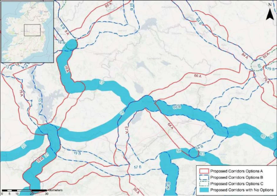
Table 16. Appraisal Relating to Corridor 16 Athlone to Longford (west of Lough Ree)
Figure B5: Map of corridor options 16, 17 and 18
| Option A | B |
|---|---|
| = | = |
| = | = |
SEA Theme Summary of the Potential Effects Associated with Corridor 16 Athlone to Longford
Option A: Option A is adjacent to Crosswood Bog SAC and pNHA, Lough Ree SAC, SPA Biodiversity and pNHA, Waterstown Lake pNHA, Derry Lough pNHA, Royal Canal pNHA, Lough Bawn pNHA, and Mount Jessop Bog SAC and NHA. These designated sites and key sensitivities associated with the designations would need to be considered further when determining the final route during scheme development. Land take requirements are not known at this stage; however it is anticipated the route would utilise existing infrastructure where practicable, such as along existing roads and cycle tracks (for example the Royal Canal Greenway). Option B: Option B is runs along and encroaches in some locations the Lough Ree SAC, SPA and pNHA along a planned greenway (Lough Ree Greenway - Athlone to Ballyleague/Lanesborough). Option B is also adjacent to Brown Bog SAC and pNHA, Ballykenny-Fisherstown Bog SPA, Lough Forbes Complex SAC and pNHA, Royal Canal pNHA, Lough Bannow pNHA, Lisnanarriagh Bog NHA, and Corbo Bog SAC and pNHA. These designated sites and key sensitivities associated with the designations would need to be considered further when determining the final route during scheme development. Land take requirements are not known at this stage; however, it is anticipated the route would utilise existing infrastructure where practicable.
Population and Human Health
The corridor options would link Longford (population c. 10,000) with Athlone (population c.21,350) supporting accessibility to the services, facilities and amenities available in these settlements. In this respect an enhancement of accessibility by active travel modes will promote social inclusion and the quality of life of residents and support health and wellbeing. The corridor options also have the potential to bring benefits for the visitor economy along the routes and support community vitality. Option A will also link Ballymahon (population c.1,880), whilst Option B will also link Lanesborough-Ballyleague (population c.1,450).
Appendix B: Corridor option assessment tables
National Cycle Network SEA Environmental Report (Updated)
Option
SEA Theme Summary of the Potential Effects Associated with Corridor 16 Athlone to Longford A B
| Land and Soils Option A: Land use along the proposed corridor / within the area varies and includes areas of urban fabric (artificial surfaces) in Athlone, Ballymahon and Longford town and areas of pastures (agricultural areas), peat bogs (wetland) and wetlands (inland marshes) as per CORINE 2018. Should the route primarily involve the reallocation of road space / recreational amenity infrastructure, loss of land and loss of productive agricultural land is unlikely to be significant. Option B: Land use along the proposed corridor / within the area is variable and includes areas of urban fabric (artificial surfaces) in Athlone and Longford town and areas of pastures (agricultural areas), peat bogs (wetland) and wetlands (inland marshes) as per CORINE 2018. Should the route primarily involve the reallocation of road space, loss of land and loss of productive agricultural land is unlikely to be significant. Should the route require some land-take (from agriculture), the impact to likely to be significant / uncertain. Option A is the preferred option for land and soils, as it aligns more along existing infrastructure (greenway / canal) and would require less land-take (from agriculture). | 1 | 2 |
|---|---|---|
| Water Option A: Several watercourses occur along the route of the proposed corridor, including the Breensford River, River Inny, River Fallan, Camlin River and the Royal Canal. The WFD status of these watercourses ranges between ‘good’ and ‘poor’ during the 2013-2018 monitoring period. The watercourses within the proposed corridor ranges from ‘at risk’ to ‘under review’. Option B: Several watercourses occur along the route of the proposed corridor, including the River Shannon, Clooneigh River, Hind River and the Camlin River. The WFD status of these watercourses ranges between ‘good’ and ‘poor’ during the 2013-2018 monitoring period. The watercourses within the proposed corridor ranges from ‘at risk’ to ‘under review’. | = | = |
| Air Quality Options A & B: The route occurs in an area considered to be of ‘Good’ air quality. The route will provide a safe cycle route between Athlone and Longford town. This will promote a modal shift to active modes of travel which will in turn support ongoing improvements to air quality in the area. | = | = |
| Climate Change The development of the corridor options as part of the NCN would promote a shift to active modes of travel from higher emission modes, including the private car. This will support a limitation of greenhouse gas emissions from transport. The corridor options may cross (and potentially negatively/positively impact on) areas of flood risk. Whilst impacts on flood risk, and, more broadly, climate change adaptation, depends on the detailed route of the corridor and scheme design, there would be a need to ensure that the delivery of the corridor options supports the resilience of the local area to the potential effects of climate change. | = | = |
| Cultural Heritage Option A: A range of cultural heritage assets are present within the proposed corridor, such as a gate lodge (Reg. No. 13002328), redundant record (LF013-063----), bridge (Reg. No. 13401816), lock (Reg. No. 13401818) and a dock (Reg. No. 13313021). The development of the cycle corridor offers the potential for the rejuvenation and enhanced enjoyment of the Royal Canal and other cultural heritage assets. However, the proposed corridor also has the potential to impact on the setting of archaeological assets which occur along the proposed corridor. Option B: A range of cultural heritage assets are present within the proposed corridor, such as a Fulacht fia (LF013-150----), bridge (Reg. No. 13307013) and a lock (Reg. No. 13307025), ford (RO037-009----). The development of the cycle corridor offers the potential for the rejuvenation and enhanced enjoyment of cultural heritage assets. However, the proposed corridor also has the potential to impact on the setting of archaeological assets which occur along the proposed corridor. Option A is the preferred option for cultural heritage, as it aligns along existing infrastructure (greenway / canal) and would rejuvenation and connect these cultural heritage assets. | 1 | 2 |
| Landscape The corridor options, given they largely follow existing transport corridors, are unlikely to lead to significant impacts on landscape character. They also offer opportunities to enhance the quality of the public realm, if high quality design and layouts are integrated within subsequent schemes. More broadly, the corridor options will support active travel modes, which are modes of transport with limited impacts on landscape character. Through promoting active travel modes, the corridor options will also support an enhanced understanding and enjoyment of the special qualities and intrinsic character of the landscape. | = | = |
Appendix B: Corridor option assessment tables AECOM
National Cycle Network
Table 17. Appraisal Relating to Corridor 17 Longford to Mullingar
Summary of the Potential Effects Associated with Corridor 17 Longford to SEA Theme Mullingar
| Biodiversity The corridor follows the Royal Canal pNHA. In addition, Mount Jessop Bog SAC and NHA, Lough Ennell SAC, SPA and pNHA, Lough Bawn pNHA, and Derry Lough pNHA are located within the corridor. These designated sites and key sensitivities associated with the designations would need to be considered further when determining the final route during scheme development. Land take requirements are not known at this stage; however it is anticipated the route would utilise existing infrastructure where practicable, such as along existing roads and cycle tracks (for example the Kildare-Longford Royal Canal Greenway, which runs adjacent to the corridor). | Uncertain |
|---|---|
| Population and The corridor would link Longford (population c.10,000) with Mullingar (population c.20,928) Human Health supporting accessibility to the services, facilities and amenities available in these settlements. In this respect an enhancement of accessibility by active travel modes will promote social inclusion and the quality of life of residents and support health and wellbeing. The corridor also has the potential to bring benefits for the visitor economy along the routes and support community vitality. | Positive |
| Land and Soils Land use along the proposed corridor / within the area is variable and includes areas of urban fabric (artificial surfaces) and industrial or commercial units (artificial surfaces) in Longford town and Mullingar town and areas of pastures (agricultural areas), mixed forest (forest and semi-natural areas), peat bogs (wetland) as per CORINE 2018. Should the route primarily involve the reallocation of road space / recreational amenity infrastructure, loss of land and loss of productive agricultural land is unlikely to be significant. | Uncertain |
| Water Several watercourses occur along the route of the proposed corridor, including the River Shannon, Clooneigh River, Hind River and the Camlin River, Inny River and the Royal Canal. The WFD status of these watercourses ranges between ‘good’ and ‘poor’ during the 2013-2018 monitoring period. The watercourses within the proposed corridor ranges from ‘at risk’ to ‘under review’. | Uncertain |
| Air Quality The route occurs in an area considered to be of ‘Good’ air quality. The route will provide a safe cycle route between Longford town and Mullingar town. This will promote a modal shift to active modes of travel which will in turn support ongoing improvements to air quality in the area. | Positive |
| Climate Change The development of the corridor as part of the NCN would promote a shift to active modes of travel from higher emission modes, including the private car. This will support a limitation of greenhouse gas emissions from transport. The corridor may cross (and potentially negatively/positively impact on) areas of flood risk. Whilst impacts on flood risk, and, more broadly, climate change adaptation, depends on the detailed route of the corridor and scheme design, there would be a need to ensure that the delivery of the corridor supports the resilience of the local area to the potential effects of climate change. | Positive |
| Cultural Heritage A range of cultural heritage assets are present within the proposed corridor, such as a gate lodge (Reg. No. 13002328), bridge (Reg. No. 13401816), ringfort (LF023-109001-), aqueduct (Reg. No. 13402337) and a bridge (Reg. No. 15401819). The development of the cycle corridor offers the potential for the rejuvenation and enhanced enjoyment of the Royal Canal and other cultural heritage assets. However, the proposed corridor also has the potential to impact on the setting of archaeological assets which occur along the proposed corridor. | Uncertain |
| Landscape The proposed corridor, given it is likely to follow existing transport infrastructure, is unlikely to lead to significant impacts on landscape character. It also offers opportunities to enhance the quality of the public realm, if high quality design and layouts are integrated within subsequent schemes. More broadly, the implementation of the corridor will support active travel modes, which are modes of transport with limited impacts on landscape character. Through promoting active travel modes, the corridor also offers opportunities to support an enhanced understanding and enjoyment of the special qualities and intrinsic character of the landscape in the vicinity of the corridor. | Positive |
Appendix B: Corridor option assessment tables
National Cycle Network
Table 18. Appraisal Relating to Corridor 18 Athlone to Mullingar
SEA Theme Summary of the Potential Effects Associated with Corridor 18 Athlone to Mullingar
| Biodiversity A number of designated sites are located In the vicinity of corridor, this includes approximately five SACs, three SPAs and eight pNHA/NHAs. This includes Lough Ree SAC, SPA and pNHA, River Shannon Callows SAC, SPA and pNHA, Crosswood Bog SAC and pNHA, and Lough Ennell SAC, SPA and pNHA. These designated sites and key sensitivities associated with the designations would need to be considered further when determining the final route during scheme development. Land take requirements are not known at this stage; however, it is anticipated the route would utilise existing infrastructure where practicable, such as along existing roads and cycle tracks (for example the Old Rail Trail Greenway and the EuroVelo 2 route which run adjacent to the corridor). | Uncertain |
|---|---|
| Population and The corridor options would link Athlone (population c.21,350) with Mullingar (population Human Health c.20,928) supporting accessibility to the services, facilities and amenities available in these settlements. In this respect an enhancement of accessibility by active travel modes will promote social inclusion and the quality of life of residents and support health and wellbeing. The corridor also has the potential to bring benefits for the visitor economy along the route and support community vitality. | Positive |
| Land and Soils Land use along the proposed corridor / within the area is variable and includes areas of urban fabric (artificial surfaces / rail corridor) and industrial or commercial units (artificial surfaces / rail corridor) in Athlone, Moate and Mullingar town and areas of pastures (agricultural areas), forest (broad-leafed) and peat bogs (wetland) as per CORINE 2018. Should the route primarily involve the reallocation of road space / recreational amenity infrastructure, loss of land and loss of productive agricultural land is unlikely to be significant. | Uncertain |
| Water Several watercourses occur along the route of the proposed corridor, including the River Shannon, Cloonbonny Stream, River Brosna and the Royal Canal. The WFD status of these watercourses ranges between ‘good’ and ‘poor’ during the 2013-2018 monitoring period. The watercourses within the proposed corridor ranges from ‘at risk’ to ‘under review’. | Uncertain |
| Air Quality The route occurs in an area considered to be of ‘Good’ air quality. The route will provide a safe cycle route between Athlone and Mullingar town. This will promote a modal shift to active modes of travel which will in turn support ongoing improvements to air quality in the area. | Positive |
| Climate Change The development of the corridor as part of the NCN would promote a shift to active modes of travel from higher emission modes, including the private car. This will support a limitation of greenhouse gas emissions from transport. The corridor may cross (and potentially negatively/positively impact on) areas of flood risk. Whilst impacts on flood risk, and, more broadly, climate change adaptation, depends on the detailed route of the corridor and scheme design, there would be a need to ensure that the delivery of the corridor supports the resilience of the local area to the potential effects of climate change. | Positive |
| Cultural Heritage A range of cultural heritage assets are present within the proposed corridor, such as a burial ground (WM029-023----), bridge (Reg. No. 15402909), ringfort (WM030-100----), footbridge (Reg. No. 15317036) and a (castle WM025-099----). Given part of the proposed corridor is located along a railway line, sensitive development of the corridor as a cycle route offers the potential for the rejuvenation and enhanced enjoyment of this heritage asset. However, the proposed corridor also has the potential to impact on the setting of other cultural heritage (archaeological) assets which may occur along the proposed corridor. | Uncertain |
| Landscape The proposed corridor, given it is likely to follow existing transport infrastructure, is unlikely to lead to significant impacts on landscape character. It also offers opportunities to enhance the quality of the public realm, if high quality design and layouts are integrated within subsequent schemes. More broadly, the implementation of the corridor will support active travel modes, which are modes of transport with limited impacts on landscape character. Through promoting active travel modes, the corridor also offers opportunities to support an enhanced understanding and enjoyment of the special qualities and intrinsic character of the landscape in the vicinity of the corridor. | Positive |
Appendix B: Corridor option assessment tables
National Cycle Network
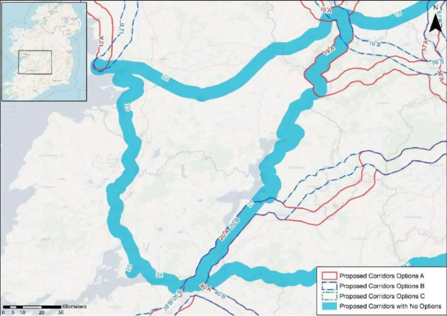
Table 19. Appraisal Relating to Corridor 19 Athlone to Tullamore (via Royal Canal)
Figure B6: Map of corridor options 19, 20, 21, 22, 23, 24 and 25
| Option A | B |
|---|---|
| = | = |
| = | = |
SEA Theme Summary of the Potential Effects Associated with Corridor 19 Athlone to Tullamore
Option A: Option A runs alongside and crosses the River Shannon Callows SAC and pNHA, Biodiversity and Middle Shannon Callows SPA before continuing along the Grand Canal pNHA. There are four SACs, three SPAs and 12 pNHA/NHAs In the vicinity of the corridor including for example Crosswood Bog SAC and pNHA, River Shannon Callows SAC and pNHA, Middle Shannon Callows SPA, Grand Canal pNHA, Grand Canal pNHA, River Suck Callows SPA, Fin Lough (Offaly) SAC and pNHA, Mongan Bog SPA and pNHA. These designated sites and key sensitivities associated with the designations would need to be considered further when determining the final route during scheme development. Land take requirements are not known at this stage; however, it is anticipated the route would utilise existing infrastructure where practicable, such as along existing cycle tracks such as the Grad Canal Greenway. Option B: A number of designated sites are located within the corridor, this includes three SACs, one SPA and eight pNHA/NHA. This includes Crosswood Bog SAC and pNHA, River Shannon Callows SAC and pNHA, Middle Shannon Callows SPA, Clonydonnin Bog NHA, Doon Esker Wood pNHA, Clara Bog SAC and pNHA and Grand Canal pNHA. These designated sites and key sensitivities associated with the designations would need to be considered further when determining the final route during scheme development. Land take requirements are not known at this stage; however it is anticipated the route would utilise existing infrastructure where practicable.
Population and Human Health
The corridor options would link Athlone (population c.21,350) with Tullamore (population c.14,600) supporting accessibility to the services, facilities and amenities available in these settlements. In this respect an enhancement of accessibility by active travel modes will promote social inclusion and the quality of life of residents and support health and wellbeing. The corridor options also have the potential to bring benefits for the visitor economy along the routes and support community vitality.
Appendix B: Corridor option assessment tables
National Cycle Network SEA Environmental Report (Updated)
Option
SEA Theme Summary of the Potential Effects Associated with Corridor 19 Athlone to Tullamore A B
| Land and Soils Option A: Land use along the proposed corridor / within the area varies and includes areas of urban fabric (artificial surfaces) and industrial or commercial units (artificial surfaces) in Athlone and Tullamore and areas of pastures (agricultural areas) and peat bogs (wetland) as per CORINE 2018. Should the route primarily involve the reallocation of road space / recreational amenity infrastructure, loss of land and loss of productive agricultural land is unlikely to be significant. Option B: Land use along the proposed corridor / within the area is variable and includes areas of urban fabric (artificial surfaces) and industrial or commercial units (artificial surfaces) in Athlone and Tullamore and areas of pastures (agricultural areas) and peat bogs (wetland) as per CORINE 2018. Should the route primarily involve the reallocation of road space / recreational amenity infrastructure, loss of land and loss of productive agricultural land is unlikely to be significant Should the route require some land-take (from agriculture), the impact to likely to be significant / uncertain. Option A is the preferred option for land and soils, as it aligns more along existing infrastructure (greenway / canal) and would require less land-take (from agriculture). | 1 | 2 |
|---|---|---|
| Water Option A: Several watercourses occur along the route of the proposed corridor, including the River Shannon, River Blackwater, Clodagh River, River Brosna, Tullamore River and the Grand Canal. The WFD status of these watercourses ranges between ‘good’ and ‘poor’ during the 2013-2018 monitoring period. The watercourses within the proposed corridor ranges from ‘at risk’ to ‘under review’. Option B: Several watercourses occur along the route of the proposed corridor, including the River Shannon, River Boor, River Brosna and the Grand Canal. The WFD status of these watercourses ranges between ‘good’ and ‘poor’ during the 2013-2018 monitoring period. The watercourses within the proposed corridor ranges from ‘at risk’ to ‘under review’. | = | = |
| Air Quality Options A & B: The route occurs in an area considered to be of ‘Good’ air quality. The route will provide a safe cycle route between Athlone and Tullamore. This will promote a modal shift to active modes of travel which will in turn support ongoing improvements to air quality in the area. | = | = |
| Climate The development of the corridor options as part of the NCN would promote a shift to active Change modes of travel from higher emission modes, including the private car. This will support a limitation of greenhouse gas emissions from transport. The corridor options may cross (and potentially negatively/positively impact on) areas of flood risk. Whilst impacts on flood risk, and, more broadly, climate change adaptation, depends on the detailed route of the corridor and scheme design, there would be a need to ensure that the delivery of the corridor options supports the resilience of the local area to the potential effects of climate change. | = | = |
| Cultural Option A: A range of cultural heritage assets are present within the proposed corridor, such as Heritage a school (Reg. No. 15008008), road (WM035-014----), rail (Reg. No. 15403513), canal (GA101- 007----), canal (GA109-054----) and bridge (Reg. No. 14914006). Given part of the proposed corridor is located along a railway line (within the peatlands), sensitive development of the corridor as a cycle route offers the potential for the rejuvenation and enhanced enjoyment of this area. However, the proposed corridor also has the potential to impact on the setting of other cultural heritage (archaeological) assets which may occur along the proposed corridor. Option B: A range of cultural heritage assets are present within the proposed corridor, such as a bridge (Reg. No. 15010122), rail (Reg. No. 15403513), structure (OF006-101----), bawn (OF006-032003-), and a bridge (Reg. No. 14801009). The development of the cycle corridor offers the potential for the rejuvenation and enhanced enjoyment of cultural heritage assets. However, the proposed corridor also has the potential to impact on the setting of archaeological assets which occur along the proposed corridor. Option A is the preferred option for cultural heritage, as it aligns along existing infrastructure (greenway / canal) and would rejuvenation and connect these cultural heritage assets along the Grand Canal. | 1 | 2 |
| Landscape The corridor options, given they largely follow existing transport corridors, are unlikely to lead to significant impacts on landscape character. They also offer opportunities to enhance the quality of the public realm, if high quality design and layouts are integrated within subsequent schemes. More broadly, the corridor options will support active travel modes, which are modes of transport with limited impacts on landscape character. Through promoting active travel modes, the corridor options will also support an enhanced understanding and enjoyment of the special qualities and intrinsic character of the landscape. | = | = |
Appendix B: Corridor option assessment tables AECOM
National Cycle Network
Table 20. Appraisal Relating to Corridor 20 Limerick to Portlaoise
SEA Theme Summary of the Potential Effects Associated with Corridor 20 Limerick to Portlaoise
| Biodiversity Option A and Option B: Option A and B traverse along the edge of the Slieve Bloom Mountains before separating into distinct options near Killeen, the options re-join near Nenagh. A number of designated sites are common to both Option A and B, these include the Ridge of Portlaoise pNHA, Slieve Bloom Mountains SAC SPA and pNHA ,River Barrow and River Nore SAC, Lough Derg pNHA, Lough Derg (Shannon) SPA, Slieve Bernagh Bog SAC, and Lower River Shannon SAC. There are approximately four SACs, two SPAs and six pNHA/NHAs in the vicinity of corridor option A and six SACs, two SPAs and seven pNHA/NHAs within corridor option B. These designated sites and key sensitivities associated with the designations would need to be considered further when determining the final route during scheme development. Land take requirements are not known at this stage; however it is anticipated the route would utilise existing infrastructure where practicable. | = | = |
|---|---|---|
| Population The corridor options would link Limerick (population c. 94,200) with Portlaoise (population and Human c.22,050) via Killaloe (population c.1,480), Ballina (population c.2,630) and Nenagh (population Health c.8,970). Option A would also link Roscrea (population c. 5,450). In this respect both corridor options would support an enhancement of accessibility by active travel modes, promoting social inclusion and the quality of life of residents and supporting health and wellbeing. The options also have the potential to bring benefits for the visitor economy along the routes and support community vitality. Option A however has the potential to bring additional benefits in relation to this SEA theme through also linking the settlement of Roscrea. | 1 | 2 |
| Land and Soils Option A: Land use along the proposed corridor / within the area varies and includes areas of urban fabric (artificial surfaces) and industrial or commercial units (artificial surfaces) in Limerick, Nenagh, Moneygall, Roscrea and Portlaoise and areas of pastures (agricultural areas), peat bogs (wetland) and mixed forest (forest and semi-natural areas) as per CORINE 2018. Should the route primarily involve the reallocation of road space, loss of land and loss of productive agricultural land is unlikely to be significant. Should the route require some land-take (from agriculture), the impact to likely to be significant / uncertain. Option B: Land use along the proposed corridor / within the area is variable and includes areas of urban fabric (artificial surfaces) and industrial or commercial units (artificial surfaces) in Limerick City, Killaloe, Nenagh and Portlaoise and areas of pastures (agricultural areas), peat bogs (wetland) and mixed forest (forest and semi-natural areas) as per CORINE 2018. Should the route primarily involve the reallocation of road space, loss of land and loss of productive agricultural land is unlikely to be significant. Should the route require some land-take (from agriculture), the impact to likely to be significant / uncertain. | = | = |
| Water Option A: Several watercourses occur along the route of the proposed corridor, including the Lough Derg, Nenagh River, Little Brosna River, Bunnow River, River Delour, River Mountrath, River Blackwater and the Shannon Estuary. The WFD status of these watercourses ranges between ‘good’ and ‘poor’ during the 2013-2018 monitoring period. The watercourses within the proposed corridor ranges from ‘at risk’ to ‘under review’. Option B: Several watercourses occur along the route of the proposed corridor, including the River Shannon, Lough Derg, Nenagh River, Gortadalaun Stream, Ballyfinboy River, Little Brosna River, Clareen Stream, River Delour, River Mountrath and the River Blackwater and the Shannon Estuary. The WFD status of these watercourses ranges between ‘good’ and ‘poor’ during the 2013-2018 monitoring period. The watercourses within the proposed corridor ranges from ‘at risk’ to ‘under review’. | = | = |
| Air Quality Options A & B: The route occurs in an area considered to be of ‘Good’ air quality. The route will provide a safe cycle route between Limerick, Nenagh and Portlaoise. This will promote a modal shift to active modes of travel which will in turn support ongoing improvements to air quality in the area. | = | = |
| Climate The development of the corridor options as part of the NCN would promote a shift to active Change modes of travel from higher emission modes, including the private car. This will support a limitation of greenhouse gas emissions from transport. Option A, through linking Roscrea, will however bring additional benefits in relation to this element of climate change mitigation. The corridor options may cross (and potentially negatively/positively impact on) areas of flood risk. Whilst impacts on flood risk, and, more broadly, climate change adaptation, depends on the detailed route of the corridor and scheme design, there would be a need to ensure that the delivery of the corridor options supports the resilience of the local area to the potential effects of climate change. | 1 | 2 |
Appendix B: Corridor option assessment tables
National Cycle Network SEA Environmental Report (Updated)
| Option A | B |
|---|---|
| = | = |
| = | = |
SEA Theme Summary of the Potential Effects Associated with Corridor 20 Limerick to Portlaoise
Cultural Heritage
Option A: A range of cultural heritage assets are present within the proposed corridor, such as a house / store (Reg. No. 21513048), enclosure (CL063-015----), Sheela-na-gig (CL053-038--- ), and a ford (TN014-057005-). The development of the cycle corridor offers the potential for the rejuvenation and enhanced enjoyment of cultural heritage assets. However, the proposed corridor also has the potential to impact on the setting of archaeological assets which occur along the proposed corridor. Option B: A range of cultural heritage assets are present within the proposed corridor, such as a house / store (Reg. No. 21513048), enclosure (CL063-015----), church (Reg. No. 22401503) and an enclosure (OF039-048----). The development of the cycle corridor offers the potential for the rejuvenation and enhanced enjoyment of cultural heritage assets. However, the proposed corridor also has the potential to impact on the setting of archaeological assets which occur along the proposed corridor.
The corridor options, given they largely follow existing transport corridors, are unlikely to lead to Landscape significant impacts on landscape character. They also offer opportunities to enhance the quality of the public realm, if high quality design and layouts are integrated within subsequent schemes. More broadly, the corridor options will support active travel modes, which are modes of transport with limited impacts on landscape character. Through promoting active travel modes, the corridor options will also support an enhanced understanding and enjoyment of the special qualities and intrinsic character of the landscape.
Appendix B: Corridor option assessment tables AECOM
National Cycle Network
Table 21. Appraisal Relating to Corridor 21 Limerick to Athlone
SEA Theme Summary of the Potential Effects Associated with Corridor 21 Limerick to Athlone
| Biodiversity A of designated sites occur in the vicinity of the corridor, including approximately nice SACs, five SPAs and 16 pNHA/NHAs. This includes for example Crosswood Bog SAC pNHA, River Shannon Callows SAC, SPA, pNHA, Mongan Bog SAC, SPA, pNHA, River Suck Callows SPA NHA and Lough Derg (Shannon) SPA. These designated sites and key sensitivities associated with the designations would need to be considered further when determining the final route during scheme development. Land take requirements are not known at this stage; however it is anticipated the route would utilise existing infrastructure where practicable, such as along existing roads and cycle tracks. | Uncertain |
|---|---|
| Population and The corridor would link Athlone (population c.21,350) with Limerick (population c.94,200) via Human Health Killaloe (population c.1,480), Ballina (population c.2,630) and Portumna (population c.1,450), supporting accessibility to the services, facilities and amenities available in these settlements. In this respect an enhancement of accessibility by active travel modes will promote social inclusion and the quality of life of residents and support health and wellbeing. The corridor also has the potential to bring benefits for the visitor economy along the route and support community vitality. | Positive |
| Land and Soils Land use along the proposed corridor / within the area varies and includes areas of urban fabric (artificial surfaces) and industrial or commercial units (artificial surfaces) in Athlone and Limerick City and areas of pastures (agricultural areas), waterbodies, wetland (inland marshes) as per CORINE 2018. Should the route primarily involve the reallocation of road space / recreational amenity infrastructure, loss of land and loss of productive agricultural land is unlikely to be significant. Should the route require some land-take (from agriculture), the impact to likely to be significant / uncertain. | Uncertain |
| Water Several watercourses occur along the route of the proposed corridor, including the River Shannon and Estuary, Lough Derg and the River Blackwater. The WFD status of these watercourses ranges between ‘good’ and ‘poor’ during the 2013-2018 monitoring period. The watercourses within the proposed corridor ranges from ‘at risk’ to ‘under review’. | Uncertain |
| Air Quality The route occurs in an area considered to be of ‘Good’ air quality. The route will provide a safe cycle route between Athlone and Limerick City. This will promote a modal shift to active modes of travel which will in turn support ongoing improvements to air quality in the area. | Positive |
| Climate Change The development of the corridor as part of the NCN would promote a shift to active modes of travel from higher emission modes, including the private car. This will support a limitation of greenhouse gas emissions from transport. The corridor may cross (and potentially negatively/positively impact on) areas of flood risk. Whilst impacts on flood risk, and, more broadly, climate change adaptation, depends on the detailed route of the corridor and scheme design, there would be a need to ensure that the delivery of the corridor supports the resilience of the local area to the potential effects of climate change. | Positive |
| Cultural Heritage A range of cultural heritage assets are present within the proposed corridor, such as a house / store (Reg. No. 21513048), church (TN014-004003-), Ecclesiastical site (TN006-003001-), bridge (Reg. No. 30412706) and castle (GA109-021---). The development of the cycle corridor offers the potential for the rejuvenation and enhanced enjoyment of cultural heritage assets. However, the proposed corridor also has the potential to impact on the setting of archaeological assets which occur along the proposed corridor. | Uncertain |
| Landscape The proposed corridor, given it is likely to follow existing transport infrastructure, is unlikely to lead to significant impacts on landscape character. It also offers opportunities to enhance the quality of the public realm, if high quality design and layouts are integrated within subsequent schemes. More broadly, the implementation of the corridor will support active travel modes, which are modes of transport with limited impacts on landscape character. Through promoting active travel modes, the corridor also offers opportunities to support an enhanced understanding and enjoyment of the special qualities and intrinsic character of the landscape in the vicinity of the corridor. | Positive |
Appendix B: Corridor option assessment tables
National Cycle Network
Table 22. Appraisal Relating to Corridor 22 Galway to Athlone
SEA Theme Summary of the Potential Effects Associated with Corridor 22 Galway to Athlone
| Biodiversity A number of designated sites occur within the surround environs, including approximately six SACs, five SPAs and 10 pNHA/NHAs. This includes the River Shannon Callows SAC pNHA, Suck River Callows SPA and NHA, and the Lough Rea SAC, SPA, pNHA and Rahasane Turlough SAC, SPA, pNHA. These designated sites and key sensitivities associated with the designations would need to be considered further when determining the final route during scheme development. Land take requirements are not known at this stage; however it is anticipated the route would utilise existing infrastructure where practicable, such as along existing roads. | Uncertain |
|---|---|
| Population and The corridor would link Athlone (population c.21,350) with the city of Galway (population Human Health c.79,950) via Loughrea (population c.5,560) and Ballinasloe (population c.6,660), supporting accessibility to the services, facilities and amenities available in these settlements. In this respect an enhancement of accessibility by active travel modes will promote social inclusion and the quality of life of residents and support health and wellbeing. The corridor also has the potential to bring benefits for the visitor economy along the route and support community vitality. | Positive |
| Land and Soils Land use along the proposed corridor / within the area is variable and includes areas of urban fabric (artificial surfaces) and industrial or commercial units (artificial surfaces) in Galway City, Loughrea, Ballinasloe and Athlone and areas of pastures (agricultural areas), peat bogs (wetland) and forest (broad-leafed) as per CORINE 2018. Should the route primarily involve the reallocation of road space, loss of land and loss of productive agricultural land is unlikely to be significant. Should the route require some land-take (from agriculture), the impact to likely to be significant / uncertain. | Uncertain |
| Water Several watercourses occur along the route of the proposed corridor, including the River Clarinbridge, River Kilcolgan, Lecarrow Stream, Ballinure River, River Suck, Cross River. The WFD status of these watercourses ranges between ‘good’ and ‘poor’ during the 2013- 2018 monitoring period. The watercourses within the proposed corridor ranges from ‘at risk’ to ‘under review’. | Uncertain |
| Air Quality The route occurs in an area considered to be of ‘Good’ air quality. The route will provide a safe cycle route between Galway City and Athlone. This will promote a modal shift to active modes of travel which will in turn support ongoing improvements to air quality in the area. | Positive |
| Climate Change The development of the corridor as part of the NCN would promote a shift to active modes of travel from higher emission modes, including the private car. This will support a limitation of greenhouse gas emissions from transport. The corridor may cross (and potentially negatively/positively impact on) areas of flood risk. Whilst impacts on flood risk, and, more broadly, climate change adaptation, depends on the detailed route of the corridor and scheme design, there would be a need to ensure that the delivery of the corridor supports the resilience of the local area to the potential effects of climate change. | Positive |
| Cultural Heritage A range of cultural heritage assets are present within the proposed corridor, such as a castle (GA082-080001-), boundary stone (GA094-030001-), house (Reg. No. 30336006) and an Architectural fragment (GA105-234----). The development of the cycle corridor offers the potential for the rejuvenation and enhanced enjoyment of cultural heritage assets. However, the proposed corridor also has the potential to impact on the setting of archaeological assets which occur along the proposed corridor. | Uncertain |
| Landscape The proposed corridor, given it is likely to follow existing transport infrastructure, is unlikely to lead to significant impacts on landscape character. It also offers opportunities to enhance the quality of the public realm, if high quality design and layouts are integrated within subsequent schemes. More broadly, the implementation of the corridor will support active travel modes, which are modes of transport with limited impacts on landscape character. Through promoting active travel modes, the corridor also offers opportunities to support an enhanced understanding and enjoyment of the special qualities and intrinsic character of the landscape in the vicinity of the corridor. | Positive |
Appendix B: Corridor option assessment tables
National Cycle Network
Table 23. Appraisal Relating to Corridor 23 Galway to Ennis
SEA Theme Summary of the Potential Effects Associated with Corridor 23 Galway to Ennis
| Biodiversity A number of designated sites occur within the surrounding environs, including approximately 12 SACs, 3 SPAs and 12 pNHA/NHAs. This includes the Galway Bay Complex SAC and pNHA, Coole-Garryland Complex SAC, SPA and pNHA, Ballyallia Lough SPA, and Lower River Shannon SAC. These designated sites and key sensitivities associated with the designations would need to be considered further when determining the final route during scheme development. Land take requirements are not known at this stage; however it is anticipated the route would utilise existing infrastructure where practicable, such as along existing roads and cycle tracks. | Uncertain |
|---|---|
| Population The corridor would link the city of Galway (population c.79,950) with Ennis (population c.25,275) and Human via Oranmore (population c.4,990), supporting accessibility to the services, facilities and Health amenities available in these settlements. In this respect an enhancement of accessibility by active travel modes will promote social inclusion and the quality of life of residents and support health and wellbeing. The corridor also has the potential to bring benefits for the visitor economy along the route and support community vitality. | Positive |
| Land and Soils Land use along the proposed corridor / within the area is variable and includes areas of urban fabric (artificial surfaces) and industrial or commercial units (artificial surfaces) in Galway City and Ennis and areas of pastures (agricultural areas), forest (broad-leafed), land principally occupied by agriculture with significant areas of natural vegetation (agricultural areas) and bare rock (forest and semi-natural areas) as per CORINE 2018. Should the route primarily involve the reallocation of road space, loss of land and loss of productive agricultural land is unlikely to be significant. Should the route require land-take from (agriculture) land, the impact to likely to be significant / uncertain. | Uncertain |
| Water Several watercourses occur along the route of the proposed corridor, including the River Corrib and Estuary, Rockhill River, Kilcolgan River, Castlelodge River, Moyree River, River Fergus and Estuary and the River Shannon and Estuary. The WFD status of these watercourses ranges between ‘good’ and ‘poor’ during the 2013-2018 monitoring period. The watercourses within the proposed corridor ranges from ‘at risk’ to ‘under review’. | Uncertain |
| Air Quality The route occurs in an area considered to be of ‘Good’ air quality. The route will provide a safe cycle route between Galway City and Ennis. This will promote a modal shift to active modes of travel which will in turn support ongoing improvements to air quality in the area. | Positive |
| Climate The development of the corridor as part of the NCN would promote a shift to active modes of Change travel from higher emission modes, including the private car. This will support a limitation of greenhouse gas emissions from transport. The corridor may cross (and potentially negatively/positively impact on) areas of flood risk. Whilst impacts on flood risk, and, more broadly, climate change adaptation, depends on the detailed route of the corridor and scheme design, there would be a need to ensure that the delivery of the corridor supports the resilience of the local area to the potential effects of climate change. | Positive |
| Cultural A range of cultural heritage assets are present within the proposed corridor, such as a castle Heritage (GA082-080001-), church (GA095-114----), church (GA095-051----) and a bridge (Reg. No. 30410330) and a Promontory fort – coastal (GA113-123----). The development of the cycle corridor offers the potential for the rejuvenation and enhanced enjoyment of cultural heritage assets. However, the proposed corridor also has the potential to impact on the setting of archaeological assets which occur along the proposed corridor. | Uncertain |
| Landscape The proposed corridor, given it is likely to follow existing transport infrastructure, is unlikely to lead to significant impacts on landscape character. It also offers opportunities to enhance the quality of the public realm, if high quality design and layouts are integrated within subsequent schemes. More broadly, the implementation of the corridor will support active travel modes, which are modes of transport with limited impacts on landscape character. Through promoting active travel modes, the corridor also offers opportunities to support an enhanced understanding and enjoyment of the special qualities and intrinsic character of the landscape in the vicinity of the corridor. | Positive |
Appendix B: Corridor option assessment tables
National Cycle Network
Table 24. Appraisal Relating to Corridor 24 Ennis to Limerick
SEA Theme Summary of the Potential Effects Associated with Corridor 24 Ennis to Limerick
| Biodiversity A number of designated sites occur in the vicinity of the corridor, including three SACs, one SPA and seven pNHA/NHA. These include the Lower River Shannon SAC, the Newhall and Edenvale Complex SAC and pNHA, the River Shannon and River Fergus Estuaries SPA, and the Fergus Estuary and Inner Shannon, North Shore pNHA, Lough Gash Turlough SAC and pNHA. These designated sites and key sensitivities associated with the designations would need to be considered further when determining the final route during scheme development. Land take requirements are not known at this stage; however, it is anticipated the route would utilise existing infrastructure where practicable, such as along existing roads and cycle tracks. | Uncertain |
|---|---|
| Population and The corridor would link Ennis (population c.25,275) with Limerick (population c.94,200) via Human Health Newmarket-On-Fergus (population c.1,785) and Shannon (population c.9,730), supporting accessibility to the services, facilities and amenities available in these settlements. In this respect an enhancement of accessibility by active travel modes will promote social inclusion and the quality of life of residents and support health and wellbeing. The corridor also has the potential to bring benefits for the visitor economy along the route and support community vitality. | Positive |
| Land and Soils Land use along the proposed corridor / within the area varies and includes areas of urban fabric (artificial surfaces) and industrial or commercial units (artificial surfaces) in Ennis, Shannon, Bunratty and Limerick City and areas of pastures (agricultural areas), road and rail network (artificial surfaces), wetland (inland marshes), land principally occupied by agriculture with significant areas of natural vegetation (agricultural areas) and estuaries (waterbodies) as per CORINE 2018. Should the route primarily involve the reallocation of road space, loss of land and loss of productive agricultural land is unlikely to be significant. Should the route require some land-take from (agriculture) land, the impact to likely to be significant / uncertain. | Uncertain |
| Water Several watercourses occur along the route of the proposed corridor, including the River Fergus, Owenogarney River and the River Shannon. The WFD status of these watercourses ranges between ‘good’ and ‘poor’ during the 2013-2018 monitoring period. The watercourses within the proposed corridor ranges from ‘at risk’ to ‘under review’. | Uncertain |
| Air Quality The route occurs in an area considered to be of ‘Good’ air quality. The route will provide a safe cycle route between Ennis and Limerick City. This will promote a modal shift to active modes of travel which will in turn support ongoing improvements to air quality in the area. | Positive |
| Climate Change The development of the corridor as part of the NCN would promote a shift to active modes of travel from higher emission modes, including the private car. This will support a limitation of greenhouse gas emissions from transport. The corridor may cross (and potentially negatively/positively impact on) areas of flood risk. Whilst impacts on flood risk, and, more broadly, climate change adaptation, depends on the detailed route of the corridor and scheme design, there would be a need to ensure that the delivery of the corridor supports the resilience of the local area to the potential effects of climate change. | Positive |
| Cultural Heritage A range of cultural heritage assets are present within the proposed corridor, such as a church (Reg. No. 20000019), Castle - Anglo-Norman masonry castle (CL041-089----), bridge (Reg. No. 20404204), ringfort (CL051-088----) and a jetty (CL062-048----). The development of the cycle corridor offers the potential for the rejuvenation and enhanced enjoyment of cultural heritage assets. However, the proposed corridor also has the potential to impact on the setting of archaeological assets which occur along the proposed corridor. | Uncertain |
| Landscape The proposed corridor, given it is likely to follow existing transport infrastructure, is unlikely to lead to significant impacts on landscape character. It also offers opportunities to enhance the quality of the public realm, if high quality design and layouts are integrated within subsequent schemes. More broadly, the implementation of the corridor will support active travel modes, which are modes of transport with limited impacts on landscape character. Through promoting active travel modes, the corridor also offers opportunities to support an enhanced understanding and enjoyment of the special qualities and intrinsic character of the landscape in the vicinity of the corridor. | Positive |
Appendix B: Corridor option assessment tables
National Cycle Network
Table 25. Appraisal Relating to Corridor 25 Shannon to Ennis / Limerick
Summary of the Potential Effects Associated with Corridor 25 Shannon to Ennis / SEA Theme Limerick
| Biodiversity The Lower River Shannon SAC, River Shannon and River Fergus Estuaries SPA, and Fergus Estuary and Inner Shannon, North Shore pNHA are all located in the vicinity of the corridor. These designated sites and key sensitivities associated with the designations would need to be considered further when determining the final route during scheme development. Land take requirements are not known at this stage; however it is anticipated the route would utilise existing infrastructure where practicable, such as along existing roads and cycle tracks (for example existing TII infrastructure where practicable). | Uncertain |
|---|---|
| Population and The corridor would link Shannon (population c.9,730) with Ennis (population c.25,275), Human Health Limerick (population c.94,200) and Newmarket-On-Fergus (population c.1,785), supporting accessibility to the services, facilities and amenities available in these settlements. In this respect an enhancement of accessibility by active travel modes will promote social inclusion and the quality of life of residents and support health and wellbeing. The corridor also has the potential to bring benefits for the visitor economy along the route and support community vitality. | Positive |
| Land and Soils Land use along the proposed corridor / within the area is variable and includes areas of urban fabric (artificial surfaces) and industrial or commercial units (artificial surfaces) in Shannon as per CORINE 2018. Should the route primarily involve the reallocation of road space, loss of land and loss of productive agricultural land is unlikely to be significant. | Uncertain |
| Water A watercourse occurs along the route of the proposed corridor, including the Urlan Beg Stream. The status of this watercourse is ‘unassigned’ and ‘under review’. | Uncertain |
| Air Quality The route occurs in an area considered to be of ‘Good’ air quality. The route will provide a safe cycle route in Shannon. This will promote a modal shift to active modes of travel which will in turn support ongoing improvements to air quality in the area. | Positive |
| Climate Change The development of the corridor as part of the NCN would promote a shift to active modes of travel from higher emission modes, including the private car. This will support a limitation of greenhouse gas emissions from transport. The corridor may cross (and potentially negatively/positively impact on) areas of flood risk. Whilst impacts on flood risk, and, more broadly, climate change adaptation, depends on the detailed route of the corridor and scheme design, there would be a need to ensure that the delivery of the corridor supports the resilience of the local area to the potential effects of climate change. | Positive |
| Cultural Heritage A range of cultural heritage assets are present within the proposed corridor, such as enclosures (CL051-176006-) and (CL051-144----) and (CL051-138----). The development of the cycle corridor offers the potential for the rejuvenation and enhanced enjoyment of cultural heritage assets. However, the proposed corridor also has the potential to impact on the setting of archaeological assets which occur along the proposed corridor. | Uncertain |
| Landscape The proposed corridor, given it is likely to follow existing transport infrastructure, is unlikely to lead to significant impacts on landscape character. It also offers opportunities to enhance the quality of the public realm, if high quality design and layouts are integrated within subsequent schemes. More broadly, the implementation of the corridor will support active travel modes, which are modes of transport with limited impacts on landscape character. Through promoting active travel modes, the corridor also offers opportunities to support an enhanced understanding and enjoyment of the special qualities and intrinsic character of the landscape in the vicinity of the corridor. | Positive |
Appendix B: Corridor option assessment tables
National Cycle Network
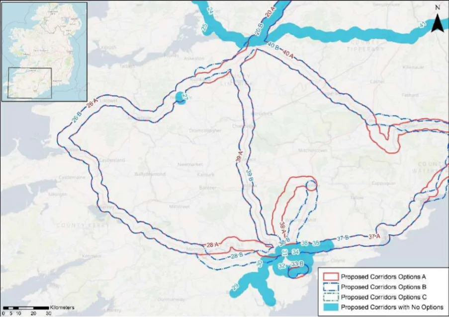
Table 26. Appraisal Relating to Corridor 26 Tralee to Limerick
Figure B7: Map of corridor options 26, 27 and 28
| Option A | B |
|---|---|
| = | = |
| = | = |
| = | = |
| = | = |
SEA Theme Summary of the Potential Effects Associated with Corridor 26 Tralee to Limerick
Options A & B: Option A and B flow a similar route with the exception of a small divergence Biodiversity near Limerick. The designated sites identified in the vicinity of the corridor options are Inner Shannon Estuary - South Shore pNHA, Loughmore Common Turlough pNHA, Lower River Shannon SAC, Adare Woodlands pNHA, Askeaton Fen Complex SAC, Cappagh Fen pNHA, Ballymorrisheen Marsh pNHA, Stack’s to Mullaghareirk Mountains, West Limerick Hills and Mount Eagle SPA, Lower River Shannon SAC, and Moanveanlagh Bog SAC and pNHA, All designated sites are common to both options. These designated sites and key sensitivities associated with the designations would need to be considered further when determining the final route during scheme development. Land take requirements are not known at this stage; however, it is anticipated the route would utilise existing infrastructure where practicable, such as along existing roads and cycle tracks (for example the Great Southern Trail - Listowel to Limerick Border).
Population and Human Health
Both of the corridor options would link Limerick (population c. 94,200) with Tralee (population c.23,700) via Adare (population c.1,130), Rathkeale (population c.1,440), Newcastle West (population c. 6,620), Abbeyfeale (population c. 2,020) and Listowel (population c.4,820). In this respect both corridor options would support an enhancement of accessibility by active travel modes, promoting social inclusion and the quality of life of residents and supporting health and wellbeing. The options also have the potential to bring benefits for the visitor economy along the routes and support community vitality.
Land and Soils Options A & B: Land use along the proposed corridor / within the area is variable and includes
areas of urban fabric (artificial surfaces) in Tralee, Listowel and Limerick City and areas of pastures (agricultural areas) and peat bogs (wetland) as per CORINE 2018. Should the route primarily involve the reallocation of road space / historic rail line, loss of land and loss of productive agricultural land is unlikely to be significant.
Options A & B: Several watercourses occur along the route of the proposed corridor, including Water the Barnakyle River, River Maigue, River Deel, River Allaghaun, River Feale and the River Lee (Tralee). The WFD status of these watercourses ranges between ‘good’ and ‘poor’ during the 2013-2018 monitoring period. The watercourses within the proposed corridor ranges from ‘at risk’ to ‘under review’.
Appendix B: Corridor option assessment tables
National Cycle Network SEA Environmental Report (Updated)
Option
SEA Theme Summary of the Potential Effects Associated with Corridor 26 Tralee to Limerick A B
| Air Quality Options A & B: The corridor options occur in an area considered to be of ‘Good’ air quality. The route will provide a safe cycle route between Tralee and Limerick City. This will promote a modal shift to active modes of travel which will in turn support ongoing improvements to air quality in the area. | = | = |
|---|---|---|
| Climate The development of the corridor options as part of the NCN would promote a shift to active Change modes of travel from higher emission modes, including the private car. This will support a limitation of greenhouse gas emissions from transport. The corridor options may cross (and potentially negatively/positively impact on) areas of flood risk. Whilst impacts on flood risk, and, more broadly, climate change adaptation, depends on the detailed route of the corridor and scheme design, there would be a need to ensure that the delivery of the corridor options supports the resilience of the local area to the potential effects of climate change. | = | = |
| Cultural Option A: A range of cultural heritage assets are present within the proposed corridor, such as Heritage a ringfort (KE021-114----), church (Reg. No. 21302101), ringfort (KE015-088----), enclosure (KE011-016----), ringfort (LI042-006----), railway station (Reg. No. 21831013) and Fulacht fia (LI020-174----) and a gate lodge (No. 21902113). Given part of the proposed corridor is located along a historic railway line, sensitive development of the corridor as a cycle route offers the potential for the rejuvenation and enhanced enjoyment of this heritage asset. However, the proposed corridor also has the potential to impact on the setting of other cultural heritage assets (e.g., archaeological remains) which may occur along the proposed corridor. Option B: A range of cultural heritage assets are present within the proposed corridor, such as a ringfort (KE021-114----), church (Reg. No. 21302101), ringfort (KE015-088----), enclosure (KE011-016----), ringfort (LI042-006----), railway station (Reg. No. 21831013) and (Reg. No. 21902016), bridge (Reg. No. 21902032) and a bridge (LI013-012----). Given part of the proposed corridor is located along a historic railway line, sensitive development of the corridor as a cycle route offers the potential for the rejuvenation and enhanced enjoyment of this heritage asset. However, the proposed corridor also has the potential to impact on the setting of other cultural heritage assets (e.g., archaeological remains) which may occur along the proposed corridor. Option B is the preferred option for cultural heritage, as it aligns along existing infrastructure (a railway line) and would rejuvenation and connect cultural heritage assets along the route. | 2 | 1 |
| Landscape The corridor options, given they largely follow existing transport corridors, are unlikely to lead to significant impacts on landscape character. They also offer opportunities to enhance the quality of the public realm, if high quality design and layouts are integrated within subsequent schemes. More broadly, the corridor options will support active travel modes, which are modes of transport with limited impacts on landscape character. Through promoting active travel modes, the corridor options will also support an enhanced understanding and enjoyment of the special qualities and intrinsic character of the landscape. | = | = |
Appendix B: Corridor option assessment tables AECOM
National Cycle Network SEA Environmental Report (Updated)
Table 27. Appraisal Relating to Corridor 27 Newcastle West to Tralee / Limerick
Summary of the Potential Effects Associated with Corridor 27 Newcastle West to SEA Theme Tralee / Limerick
| Biodiversity No designated sites are located In the vicinity of the route. The corridor is located within a built-up area of hardstanding made up of residential and industrial areas with intermittent sections of agricultural land. Land take requirements are not known at this stage; however, it is anticipated the route would utilise existing infrastructure where practicable. | Neutral | |
|---|---|---|
| Population and The corridor would link Newcastle West (population c.6,620) with Limerick (population c. Human Health 94,200) and Tralee (population c.23,700) via Adare (population c.1,130), Rathkeale (population c.1,440), Abbeyfeale (population c.2,020) and Listowel (population c.4,820). In this respect the corridor would support an enhancement of accessibility by active travel modes, promoting social inclusion and the quality of life of residents and supporting health and wellbeing. The options also have the potential to bring benefits for the visitor economy along the corridor and support community vitality. | Positive | |
| Land and Soil Land use along the proposed corridor is an area of urban fabric (artificial surfaces) in Newcastle West as per CORINE 2018. Should the route primarily involve the reallocation of road space / historic rail line, loss of land and loss of productive agricultural land is unlikely to be significant. | Positive | |
| Water There are no watercourses along the route of the proposed corridor. | Neutral | |
| Air Quality The route occurs in an area considered to be of ‘Good’ air quality. The route will provide a safe cycle route in Newcastle West. This will promote a modal shift to active modes of travel which will in turn support ongoing improvements to air quality in the area. | Positive | |
| Climate Change The development of the corridor as part of the NCN would promote a shift to active modes of travel from higher emission modes, including the private car. This will support a limitation of greenhouse gas emissions from transport. The corridor may cross (and potentially negatively/positively impact on) areas of flood risk. Whilst impacts on flood risk, and, more broadly, climate change adaptation, depends on the detailed route of the corridor and scheme design, there would be a need to ensure that the delivery of the corridor supports the resilience of the local area to the potential effects of climate change. | Positive | |
| Cultural Heritage A number of cultural heritage assets are present within the proposed corridor, such as a ringfort (LI036-075----) and railings / gate (Reg. No. 21837050). Given part of the proposed corridor is located along a historic railway line, sensitive development of the corridor as a cycle route offers the potential for the rejuvenation and enhanced enjoyment of this heritage asset. However, the proposed corridor also has the potential to impact on the setting of other cultural heritage assets (e.g., archaeological remains) which may occur along the proposed corridor. | Uncertain | |
| Landscape The proposed corridor, given it is likely to follow existing transport infrastructure, is unlikely to lead to significant impacts on landscape character. It also offers opportunities to enhance the quality of the public realm, if high quality design and layouts are integrated within subsequent schemes. More broadly, the implementation of the corridor will support active travel modes, which are modes of transport with limited impacts on landscape character. Through promoting active travel modes, the corridor also offers opportunities to support an enhanced understanding and enjoyment of the special qualities and intrinsic character of the landscape in the vicinity of the corridor. | Positive |
Appendix B: Corridor option assessment tables
National Cycle Network
Table 28. Appraisal Relating to Corridor 28 Cork to Tralee (south of N22)
SEA Theme Summary of the Potential Effects Associated with Corridor 28 Cork to Tralee
| Biodiversity Options A & B: Option A and B follow a similar route, with the exception of a divergence from Cork to Ummera. Option A traverses approximately eight SACs, four SPAs, and 15 pNHA/NHAs, while Option B traverses approximately eight SACs, four SPAs, and 11 pNHA/NHAs. Designated sites common to both include for example the Gearagh SAC, SPA and pNHA, the Mullaghanish to Musheramore Mountains SPA, Killarney National Park, the Macgillycuddy’s Reeks and Caragh River Catchment SAC and pNHA, Killarney National Park SPA, Ballyseedy Wood SAC, the Tralee Bay and Magharees Peninsula, West to Cloghane SAC and pNHA, and the Tralee Bay Complex SPA. These designated sites and key sensitivities associated with the designations would need to be considered further when determining the final route during scheme development. Land take requirements are not known at this stage; however, it is anticipated the routes would utilise existing infrastructure where practicable, such as along existing roads and cycleways (such as the Lee to Sea greenway). | 2 | 1 |
|---|---|---|
| Population and The corridor options would link the city of Cork (population c.208,670) with Tralee Human Health (population c.23,700) via Killarney (population c. 14,500) and Macroom (population c.3,765). Option A will also link Tower (population c.3,420), whilst Option B will also link Killumney (population c.1,130). This will support accessibility to the services, facilities and amenities and job opportunities available in these settlements. In this respect an enhancement of accessibility by active travel modes will promote social inclusion and the quality of life of residents and support health and wellbeing. The corridor options also have the potential to bring benefits for the visitor economy along the routes and support community vitality. | = | = |
| Land and Soil Option A: Land use along the proposed corridor / within the area varies and includes areas of urban fabric (artificial surfaces) in Tralee, Kilarney, Macroom and Cork City and areas of pastures (agricultural areas), non-irrigated arable land (agricultural areas), peat bogs (wetland), mixed forest (forest and semi-natural areas) as per CORINE 2018. Should the route primarily involve the reallocation of road space, loss of land and loss of productive agricultural land is unlikely to be significant. Should the route require some land-take (from agriculture), the impact to likely to be significant / uncertain. Option B: Land use along the proposed corridor / within the area is variable and includes areas of urban fabric (artificial surfaces) in Tralee, Kilarney, Macroom and Cork City and areas of pastures (agricultural areas), non-irrigated arable land (agricultural areas), peat bogs (wetland), mixed forest (forest and semi-natural areas) as per CORINE 2018. Should the route primarily involve the reallocation of road space / historic rail line, loss of land and loss of productive agricultural land is unlikely to be significant. Option B is the preferred option for land and soils, as it aligns more along existing infrastructure (railway line) and would require less land-take (from agriculture). | 2 | 1 |
| Water Option A: Several watercourses occur along the route of the proposed corridor, including the River Lee (Tralee), River Maine, River Flesk, River Sullane, River Lee and Estuary and River Laney and Lough Carrigdrohid. The WFD status of these watercourses ranges between ‘good’ and ‘poor’ during the 2013-2018 monitoring period. The watercourses within the proposed corridor ranges from ‘at risk’ to ‘under review’. Option B: Several watercourses occur along the route of the proposed corridor, including the River Lee (Tralee), River Maine, River Flesk, River Sullane, River Lee and Estuary, River Bride and the River Curragheen and Lough Carrigdrohid. The WFD status of these watercourses ranges between ‘good’ and ‘poor’ during the 2013-2018 monitoring period. The watercourses within the proposed corridor ranges from ‘at risk’ to ‘under review’. | = | = |
| Air Quality Options A & B: The route occurs in an area considered to be of ‘Good’ air quality. The route will provide a safe cycle route between Tralee and Cork City. This will promote a modal shift to active modes of travel which will in turn support ongoing improvements to air quality in the area. | = | = |
| Climate Change The development of the corridor options as part of the NCN would promote a shift to active modes of travel from higher emission modes, including the private car. This will support a limitation of greenhouse gas emissions from transport. The corridor options may cross (and potentially negatively/positively impact on) areas of flood risk. Whilst impacts on flood risk, and, more broadly, climate change adaptation, depends on the detailed route of the corridor and scheme design, there would be a need to ensure that the delivery of the corridor options supports the resilience of the local area to the potential effects of climate change. | = | = |
Appendix B: Corridor option assessment tables
National Cycle Network SEA Environmental Report (Updated)
| Option A | B |
|---|---|
| 2 | 1 |
| = | = |
SEA Theme Summary of the Potential Effects Associated with Corridor 28 Cork to Tralee
Option A: A range of cultural heritage assets are present within the proposed corridor, Cultural Heritage such as enclosures (KE038-015----) and (KE038-119----) and (KE038-117----), fulacht fia (KE039-210----), ringforts (KE039-040----) and (KE066-039----), standing stone (KE067- 032----) and a fulacht fia (CO072-035----). The development of the cycle corridor offers the potential for the rejuvenation and enhanced enjoyment of cultural heritage assets. However, the proposed corridor also has the potential to impact on the setting of archaeological assets which occur along the proposed corridor. Option B: A range of cultural heritage assets are present within the proposed corridor, such as enclosures (KE038-015----) and (KE038-119----) and (KE038-117----), fulacht fia (KE039-210----), ringforts (KE039-040----) and (KE066-039----), gate lodge (Reg. No. 20907107), monument (Reg. No. 20908319), castle (CO084-022001-) and a souterrain (CO084-026003-). Given part of the proposed corridor is located along a historic railway line, sensitive development of the corridor as a cycle route offers the potential for the rejuvenation and enhanced enjoyment of this heritage asset. However, the proposed corridor also has the potential to impact on the setting of other cultural heritage assets (e.g., archaeological remains) which may occur along the proposed corridor. Option B is the preferred option for cultural heritage, as it aligns along existing infrastructure (historic railway line) and would rejuvenation and connect the cultural heritage assets along this route.
The corridor options, given they largely follow existing transport corridors, are unlikely to Landscape lead to significant impacts on landscape character. They also offer opportunities to enhance the quality of the public realm, if high quality design and layouts are integrated within subsequent schemes. More broadly, the corridor options will support active travel modes, which are modes of transport with limited impacts on landscape character. Through promoting active travel modes, the corridor options will also support an enhanced understanding and enjoyment of the special qualities and intrinsic character of the landscape.
Appendix B: Corridor option assessment tables AECOM
National Cycle Network SEA Environmental Report (Updated)
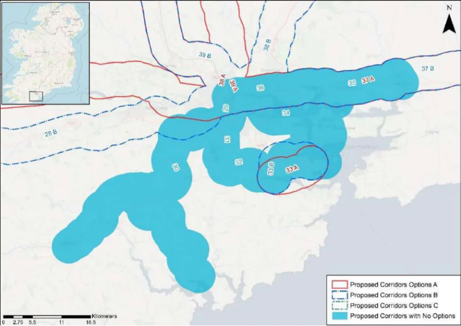
Table 29. Appraisal Relating to Corridor 29 Cork to Bandon
Figure B8: Map of corridor options 29, 30, 31, 32, 33, 34 and 36 (see Figure B9 for option 35)
SEA Theme Summary of the Potential Effects Associated with Corridor 29 Cork to Bandon
The Cork Harbour SPA, Cork Lough pNHA, the Douglas River Estuary pNHA, the Bandon Biodiversity Valley above Inishannon pNHA and the Bandon Valley West of Bandon pNHA are all located in the vicinity of the corridor. These designated sites and key sensitivities associated with the designations would need to be considered further when determining the final route during scheme development. Land take requirements are not known at this stage; however it is anticipated the route would utilise existing infrastructure where practicable, such as along existing roads and historic railways.
Population and Human Health
The corridor would link the city of Cork (population c.208,670) with Bandon (population c.6,960). In this respect the corridor would support an enhancement of accessibility by active travel modes, promoting social inclusion and the quality of life of residents and supporting health and wellbeing. The option also has the potential to bring benefits for the visitor economy along the corridor and support community vitality.
Land use along the proposed corridor / within the area varies and includes areas of urban Land and Soils fabric (artificial surfaces) and industrial or commercial units (artificial surfaces) in Bandon and Cork City and areas of pastures (agricultural areas), mixed forest (forest and seminatural areas), land principally occupied by agriculture with significant areas of natural vegetation (agricultural areas) as per CORINE 2018. Should the route primarily involve the reallocation of road space / historic rail line, loss of land and loss of productive agricultural land is unlikely to be significant.
Several watercourses occur along the route of the proposed corridor, including the River Water Bandon, River Owenboy, River Moneygurney and the River Lee and Lee Estuary. The WFD status of these watercourses ranges between ‘good’ and ‘poor’ during the 2013-2018 monitoring period. The watercourses within the proposed corridor ranges from ‘at risk’ to ‘under review’.
The route occurs in an area considered to be of ‘Good’ air quality. The route will provide a Air Quality safe cycle route between Bandon and Cork City. This will promote a modal shift to active modes of travel which will in turn support ongoing improvements to air quality in the area.
The development of the corridor as part of the NCN would promote a shift to active modes Climate Change of travel from higher emission modes, including the private car. This will support a limitation of greenhouse gas emissions from transport.
Appendix B: Corridor option assessment tables
National Cycle Network SEA Environmental Report (Updated)
SEA Theme Summary of the Potential Effects Associated with Corridor 29 Cork to Bandon Impact
The corridor may cross (and potentially negatively/positively impact on) areas of flood risk. Whilst impacts on flood risk, and, more broadly, climate change adaptation, depends on the detailed route of the corridor and scheme design, there would be a need to ensure that the delivery of the corridor supports the resilience of the local area to the potential effects of climate change.
A range of cultural heritage assets are present within the proposed corridor, such as a Cultural Heritage gasworks (CO110-025002-), tunnels (Reg. No. 20911041) and (Reg. No. 20909645), ringfort (CO096-059----), bridge (Reg. No. 20909709) and a viaduct (Reg. No. 20909728. Given part of the proposed corridor is located along a historic railway line, sensitive development of the corridor as a cycle route offers the potential for the rejuvenation and enhanced enjoyment of this heritage asset. However, the proposed corridor also has the potential to impact on the setting of other cultural heritage assets (e.g., archaeological remains) which may occur along the proposed corridor.
Uncertain
The proposed corridor, given it is likely to follow existing transport infrastructure, is unlikely Landscape to lead to significant impacts on landscape character. It also offers opportunities to enhance the quality of the public realm, if high quality design and layouts are integrated within subsequent schemes. More broadly, the implementation of the corridor will support active travel modes, which are modes of transport with limited impacts on landscape character. Through promoting active travel modes, the corridor also offers opportunities to support an enhanced understanding and enjoyment of the special qualities and intrinsic character of the landscape in the vicinity of the corridor.
Positive
Appendix B: Corridor option assessment tables AECOM
National Cycle Network
Table 30. Appraisal Relating to Corridor 30 Cork to Kinsale
SEA Theme Summary of the Potential Effects Associated with Corridor 30 Cork to Kinsale
| Biodiversity The Cork Lough pNHA, the Douglas River Estuary pNHA, the Cork Harbour SPA and the James Fort pHNA are all located in the vicinity of the corridor, however the James Fort pHNA is separated from the corridor by the River Bandon. These designated sites and key sensitivities associated with the designations would need to be considered further when determining the final route during scheme development. Land take requirements are not known at this stage; however, it is anticipated the route would utilise existing infrastructure where practicable, such as along existing roads and historic railways. | Uncertain |
|---|---|
| Population and The corridor would link the city of Cork (population c.208,670) with Kinsale (population Human Health c.5,280). In this respect the corridor would support an enhancement of accessibility by active travel modes, promoting social inclusion and the quality of life of residents and supporting health and wellbeing. The corridor also has the potential to bring benefits for the visitor economy along the corridor and support community vitality. | Positive |
| Land and Soils Land use along the proposed corridor / within the area varies and includes areas of urban fabric (artificial surfaces) and industrial or commercial units (artificial surfaces) in Kinsale and Cork City and areas of pastures (agricultural areas) and non-irrigated arable land (agricultural areas) as per CORINE 2018. Should the route primarily involve the reallocation of road space / historic rail line, loss of land and loss of productive agricultural land is unlikely to be significant. | Positive |
| Water Several watercourses occur along the route of the proposed corridor, including the River Farranamoy, River Owenboy, River Moneygurney and the River Lee. The WFD status of these watercourses ranges between ‘good’ and ‘poor’ during the 2013-2018 monitoring period. The watercourses within the proposed corridor ranges from ‘at risk’ to ‘under review’. | Uncertain |
| Air Quality The route occurs in an area considered to be of ‘Good’ air quality. The route will provide a safe cycle route between Kinsale and Cork City. This will promote a modal shift to active modes of travel which will in turn support ongoing improvements to air quality in the area. | Positive |
| Climate Change The development of the corridor as part of the NCN would promote a shift to active modes of travel from higher emission modes, including the private car. This will support a limitation of greenhouse gas emissions from transport. The corridor may cross (and potentially negatively/positively impact on) areas of flood risk. Whilst impacts on flood risk, and, more broadly, climate change adaptation, depends on the detailed route of the corridor and scheme design, there would be a need to ensure that the delivery of the corridor supports the resilience of the local area to the potential effects of climate change. | Positive |
| Cultural Heritage A range of cultural heritage assets are present within the proposed corridor, such as a bridge (Reg. No. 20911208), bridge (Reg. No. 20909725), country house (CO097-014001- ), bridge (Reg. No. 20909709) and a viaduct (Reg. No. 20909728. Given part of the proposed corridor is located along a historic railway line, sensitive development of the corridor as a cycle route offers the potential for the rejuvenation and enhanced enjoyment of this heritage asset. However, the proposed corridor also has the potential to impact on the setting of other cultural heritage assets (e.g., archaeological remains) which may occur along the proposed corridor. | Uncertain |
| Landscape The proposed corridor, given it is likely to follow existing transport infrastructure, is unlikely to lead to significant impacts on landscape character. It also offers opportunities to enhance the quality of the public realm, if high quality design and layouts are integrated within subsequent schemes. More broadly, the implementation of the corridor will support active travel modes, which are modes of transport with limited impacts on landscape character. Through promoting active travel modes, the corridor also offers opportunities to support an enhanced understanding and enjoyment of the special qualities and intrinsic character of the landscape in the vicinity of the corridor. | Positive |
Appendix B: Corridor option assessment tables
National Cycle Network
Table 31. Appraisal Relating to Corridor 31 Cork to Cork Airport
SEA Theme Summary of the Potential Effects Associated with Corridor 31 Cork to Cork Airport
| Biodiversity Cork Lough pNHA, Douglas River Estuary pNHA, and Cork Harbour SPA are all located within the corridor. These designated sites and key sensitivities associated with the designations would need to be considered further when determining the final route during scheme development. Land take requirements are not known at this stage; however it is anticipated the route would utilise existing infrastructure where practicable, such as along existing roads and cycle tracks (for example existing TII infrastructure where practicable). | Uncertain |
|---|---|
| Population and The corridor would link the city of Cork (population c.208,670) with Cork Airport. This will Human Health support an enhancement of accessibility by active travel modes to this key employment centre, promoting social inclusion. The option also has the potential to bring benefits for the visitor economy and promote sustainable tourism. | Positive |
| Land and Soils Land use along the proposed corridor / within the area is variable and includes areas of urban fabric (artificial surfaces), sport and leisure facilities (artificial surfaces) and industrial or commercial units (artificial surfaces) in Cork City and Cork Airport as per CORINE 2018. Should the route primarily involve the reallocation of road space, loss of land and loss of productive agricultural land is unlikely to be significant. | Uncertain |
| Water Several watercourses occur along the route of the proposed corridor, including the River Moneygurney and the River Lee. The status of this watercourse is ‘unassigned’ and ‘under review’. | Uncertain |
| Air Quality The route occurs in an area considered to be of ‘Good’ air quality. The route will provide a safe cycle route between Cork City and Cork Airport. This will promote a modal shift to active modes of travel which will in turn support ongoing improvements to air quality in the area. | Positive |
| Climate Change The development of the corridor as part of the NCN would promote a shift to active modes of travel from higher emission modes, including the private car. This will support a limitation of greenhouse gas emissions from transport. The corridor may cross (and potentially negatively/positively impact on) areas of flood risk. Whilst impacts on flood risk, and, more broadly, climate change adaptation, depends on the detailed route of the corridor and scheme design, there would be a need to ensure that the delivery of the corridor supports the resilience of the local area to the potential effects of climate change. | Positive |
| Cultural Heritage A range of cultural heritage assets are present within the proposed corridor, such as a railway station (CO074-119001-) and a mass rock (CO086-069----). The development of the cycle corridor offers the potential for the rejuvenation and enhanced enjoyment of cultural heritage assets. However, the proposed corridor also has the potential to impact on the setting of archaeological assets which occur along the proposed corridor. | Uncertain |
| Landscape The proposed corridor, given it is likely to follow existing transport infrastructure, is unlikely to lead to significant impacts on landscape character. It also offers opportunities to enhance the quality of the public realm, if high quality design and layouts are integrated within subsequent schemes. More broadly, the implementation of the corridor will support active travel modes, which are modes of transport with limited impacts on landscape character. Through promoting active travel modes, the corridor also offers opportunities to support an enhanced understanding and enjoyment of the special qualities and intrinsic character of the landscape in the vicinity of the corridor. | Positive |
Appendix B: Corridor option assessment tables
National Cycle Network
Table 32. Appraisal Relating to Corridor 32 Cork Airport to Carrigaline
Summary of the Potential Effects Associated with Corridor 32 Cork Airport to SEA Theme Carrigaline
| Biodiversity The Cork Harbour SPA and Owenboy River pNHA are located in the vicinity of the corridor. These designated sites and key sensitivities associated with the designations would need to be considered further when determining the final route during scheme development. Land take requirements are not known at this stage; however it is anticipated the route would utilise existing infrastructure where practicable, such as along existing roads (for example Kinsale Road and Ballea Road where practicable). | Uncertain |
|---|---|
| Population and The corridor would link Carrigaline (population c. 15,770) with Cork Airport. This will support Human Health an enhancement of accessibility by active travel modes to this key employment centre, promoting social inclusion. The option also has the potential to bring benefits for the visitor economy and sustainable tourism. | Positive |
| Land and Soils Land use along the proposed corridor / within the area is variable and includes areas of urban fabric (artificial surfaces) and airport (artificial surfaces) in Cork Airport and Carrigaline and areas of pastures (agricultural areas) and forest (broad-leafed) as per CORINE 2018. Should the route primarily involve the reallocation of road space, loss of land and loss of productive agricultural land is unlikely to be significant. | Uncertain |
| Water The watercourse along the route of the proposed corridor is the River Owenboy. The WFD status of this watercourse is ‘moderate’ during the 2013-2018 monitoring period. The watercourse is ‘at risk’. | Uncertain |
| Air Quality The route occurs in an area considered to be of ‘Good’ air quality. The route will provide a safe cycle route between Cork Airport and Carrigaline. This will promote a modal shift to active modes of travel which will in turn support ongoing improvements to air quality in the area. | Positive |
| Climate Change The development of the corridor as part of the NCN would promote a shift to active modes of travel from higher emission modes, including the private car. This will support a limitation of greenhouse gas emissions from transport. The corridor may cross (and potentially negatively/positively impact on) areas of flood risk. Whilst impacts on flood risk, and, more broadly, climate change adaptation, depends on the detailed route of the corridor and scheme design, there would be a need to ensure that the delivery of the corridor supports the resilience of the local area to the potential effects of climate change. | Positive |
| Cultural Heritage A range of cultural heritage assets are present within the proposed corridor, such as an outbuilding (Reg. No. 20908614), house (Reg. No. 20908638) and a bridge (Reg. No. 20908641). The development of the cycle corridor offers the potential for the rejuvenation and enhanced enjoyment of cultural heritage assets. However, the proposed corridor also has the potential to impact on the setting of archaeological assets which occur along the proposed corridor. | Uncertain |
| Landscape The proposed corridor, given it is likely to follow existing transport infrastructure, is unlikely to lead to significant impacts on landscape character. It also offers opportunities to enhance the quality of the public realm, if high quality design and layouts are integrated within subsequent schemes. More broadly, the implementation of the corridor will support active travel modes, which are modes of transport with limited impacts on landscape character. Through promoting active travel modes, the corridor also offers opportunities to support an enhanced understanding and enjoyment of the special qualities and intrinsic character of the landscape in the vicinity of the corridor. | Positive |
Appendix B: Corridor option assessment tables
National Cycle Network
Table 33. Appraisal Relating to Corridor 33 Port of Cork to Carrigaline
Summary of the Potential Effects Associated with Corridor 33 Port of Cork to SEA Theme Carrigaline
| Biodiversity Options A & B: Both options traverse Cork Harbour SPA, Monkstown Creek pNHA, and Owenboy River pNHA. Option A is also adjacent to Lough Beg (Cork). These designated sites and key sensitivities associated with the designations would need to be considered further when determining the final route during scheme development. Land take requirements are not known at this stage; however, it is anticipated the route would utilise existing infrastructure where practicable, such as along existing roads and cycleways (for example the Cork Harbour Greenway). | = | = | ||
|---|---|---|---|---|
| Population The corridor options will both link Carrigaline to the Port of Cork. This will support an and Human enhancement of accessibility by active travel modes to this key employment centre, promoting Health social inclusion. The option also has the potential to bring benefits for the visitor economy and sustainable tourism. | = | = | ||
| Land and Soils Option A: Land use along the proposed corridor / within the area is variable and includes areas of urban fabric (artificial surfaces) in Carrigaline and industrial or commercial units (artificial surfaces and seaport) in Cork Port and areas of pastures (agricultural areas) as per CORINE 2018. Should the route primarily involve the reallocation of road space, loss of land and loss of productive agricultural land is unlikely to be significant. Option B: Land use along the proposed corridor / within the area is variable and includes areas of urban fabric (artificial surfaces) in Carrigaline and industrial or commercial units (artificial surfaces and seaport) in Cork Port and areas of pastures (agricultural areas) as per CORINE 2018. Should the route primarily involve the reallocation of road space / historic rail line, loss of land and loss of productive agricultural land is unlikely to be significant. Option B is likely to perform more favourably in relation to this SEA theme as it aligns more along existing infrastructure (historic rail line) and would require less land-take (from agriculture). | 2 | 1 | ||
| Water Options A & B: There are no watercourses along the routes of the proposed corridor options. | = | = | ||
| Air Quality Options A & B: The route occurs in an area considered to be of ‘Good’ air quality. The route will provide a safe cycle route between Carrigaline and Cork Port. This will promote a modal shift to active modes of travel which will in turn support ongoing improvements to air quality in the area. | = | = | ||
| Climate The development of the corridor options as part of the NCN would promote a shift to active Change modes of travel from higher emission modes, including the private car. This will support a limitation of greenhouse gas emissions from transport. The corridor options may cross (and potentially negatively/positively impact on) areas of flood risk. Whilst impacts on flood risk, and, more broadly, climate change adaptation, depends on the detailed route of the corridor and scheme design, there would be a need to ensure that the delivery of the corridor options supports the resilience of the local area to the potential effects of climate change. | = | = | ||
| Cultural Option A: A range of cultural heritage assets are present within the proposed corridor, such Heritage as an outbuilding (Reg. No. 20987031), house (Reg. No. 20987033) and a church (CO087- 051002-). The development of the cycle corridor offers the potential for the rejuvenation and enhanced enjoyment of cultural heritage assets. However, the proposed corridor also has the potential to impact on the setting of archaeological assets which occur along the proposed corridor. Option B: A range of cultural heritage assets are present within the proposed corridor, such as a curate’s house (Reg. No. 20987048), bridge (Reg. No. 20987009) and a church (Reg. No. 20987029). Given part of the proposed corridor is located along a historic railway line, sensitive development of the corridor as a cycle route offers the potential for the rejuvenation and enhanced enjoyment of this heritage asset. However, the proposed corridor also has the potential to impact on the setting of other cultural heritage assets (e.g., archaeological remains) which may occur along the proposed corridor. Option B is likely to perform more favourably in relation to this SEA theme, as it aligns along existing infrastructure (railway line) and would rejuvenation and connect cultural heritage assets along this route. | 2 | 1 |
Appendix B: Corridor option assessment tables
National Cycle Network SEA Environmental Report (Updated)
| Option A | B |
|---|---|
| = | = |
Summary of the Potential Effects Associated with Corridor 33 Port of Cork to SEA Theme Carrigaline
The corridor options, given they largely follow existing transport corridors, are unlikely to lead Landscape to significant impacts on landscape character. They also offer opportunities to enhance the quality of the public realm, if high quality design and layouts are integrated within subsequent schemes. More broadly, the corridor options will support active travel modes, which are modes of transport with limited impacts on landscape character. Through promoting active travel modes, the corridor options will also support an enhanced understanding and enjoyment of the special qualities and intrinsic character of the landscape.
Appendix B: Corridor option assessment tables AECOM
National Cycle Network
Table 34. Appraisal Relating to Corridor 34 Cork to Port of Cork
SEA Theme Summary of the Potential Effects Associated with Corridor 34 Cork to Port of Cork
| Biodiversity The route traverses the Cork Harbour SPA, Monkstown Creek pNHA, Douglas River Estuary pNHA, and is in proximity to Lough Beg (Cork) pNHA, Owenboy River pNHA, Dunkettle Shore pNHA, Glanmire Wood pNHA, Rockfarm Quarry, Little Island pNHA, and Great Island Channel SAC and pNHA. These designated sites and key sensitivities associated with the designations would need to be considered further when determining the final route during scheme development. Land take requirements are not known at this stage; however, it is anticipated the route would utilise existing infrastructure where practicable, such as along existing roads and cycleways (for example the Cork Harbour Greenway) | Uncertain |
|---|---|
| Population and The corridor would link the city of Cork (population c.208,670) with the Port of Cork. This Human Health will support an enhancement of accessibility by active travel modes to this key employment centre, promoting social inclusion. The option also has the potential to bring benefits for the visitor economy and support sustainable tourism. | Positive |
| Land and Soils Land use along the proposed corridor / within the area is variable and includes areas of urban fabric (artificial surfaces), industrial or commercial units (artificial surfaces and seaport) in Cork City, Passage West, Monkstown and Cork Port and areas of pastures (agricultural areas) and non-irrigated arable land (agricultural areas) as per CORINE 2018. Should the route primarily involve the reallocation of road space / historic rail line, loss of land and loss of productive agricultural land is unlikely to be significant. | Positive |
| Water The watercourses along the route of the proposed corridor are the River Lee and Lough Mahon. The WFD status of the River Lee and Lough Mahon is ‘moderate’ during the 2013- 2018 monitoring period. The watercourse is ‘at risk’. | Uncertain |
| Air Quality The route occurs in an area considered to be of ‘Good’ air quality. The route will provide a safe cycle route between Cork City and Cork Port. This will promote a modal shift to active modes of travel which will in turn support ongoing improvements to air quality in the area. | Positive |
| Climate Change The development of the corridor as part of the NCN would promote a shift to active modes of travel from higher emission modes, including the private car. This will support a limitation of greenhouse gas emissions from transport. The corridor may cross (and potentially negatively/positively impact on) areas of flood risk. Whilst impacts on flood risk, and, more broadly, climate change adaptation, depends on the detailed route of the corridor and scheme design, there would be a need to ensure that the delivery of the corridor supports the resilience of the local area to the potential effects of climate change. | Positive |
| Cultural Heritage A range of cultural heritage assets are present within the proposed corridor, such as a building (Reg. No. 20508016), castle (CO074-049----), bridge (Reg. No. 20868051) and railway bridges (CO074-121----) and (CO074-068----) and a kiln (CO087-026----). Given part of the proposed corridor is located along a historic railway line, sensitive development of the corridor as a cycle route offers the potential for the rejuvenation and enhanced enjoyment of this heritage asset. However, the proposed corridor also has the potential to impact on the setting of other cultural heritage assets (e.g., archaeological remains) which may occur along the proposed corridor. | Uncertain |
| Landscape The proposed corridor, given it is likely to follow existing transport infrastructure, is unlikely to lead to significant impacts on landscape character. It also offers opportunities to enhance the quality of the public realm, if high quality design and layouts are integrated within subsequent schemes. More broadly, the implementation of the corridor will support active travel modes, which are modes of transport with limited impacts on landscape character. Through promoting active travel modes, the corridor also offers opportunities to support an enhanced understanding and enjoyment of the special qualities and intrinsic character of the landscape in the vicinity of the corridor. | Positive |
Appendix B: Corridor option assessment tables
National Cycle Network
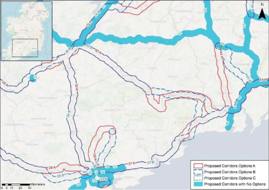
Table 35. Appraisal Relating to Corridor 35 Cobh to Midleton
Figure B9: Map of corridor options 35, 36, 37 and 38
SEA Theme Summary of the Potential Effects Associated with Corridor 35 Cobh to Midleton
The Cork Harbour SPA, Great Island Channel SAC and pNHA, and Cuskinny Marsh, Biodiversity Carrigshane Hill pNHA occur along the potential corridor. These designated sites and key sensitivities associated with the designations would need to be considered further when determining the final route during scheme development. Land take requirements are not known at this stage; however it is anticipated the route would utilise existing infrastructure where practicable, such as along existing roads and cycleways (for example EuroVelo 1 if complete).
Population and Human Health
The corridor would link Cobh (population c.12,800) with Midleton (population c.12,500) and Carrigtwohill (population c.5,080). In this respect the corridor would support an enhancement of accessibility by active travel modes, promoting social inclusion and the quality of life of residents and supporting health and wellbeing. The corridor also has the potential to bring benefits for the visitor economy along the corridor and support community vitality.
Land use along the proposed corridor / within the area is variable and includes areas of Land and Soils urban fabric (artificial surfaces), industrial or commercial units (artificial surfaces) in Cobh, Carrigtwohill and Midleton and areas of pastures (agricultural areas) and non-irrigated arable land (agricultural areas), forest (broad-leafed), intertidal flats (wetlands) as per CORINE 2018. Should the route primarily involve the reallocation of road space, loss of land and loss of productive agricultural land is unlikely to be significant.
Several watercourses occur along the route of the proposed corridor, including the River Water Lee, Tibbotstown Stream and the Owennacurra River. The WFD status of these watercourses ranges between ‘moderate’ and ‘poor’ during the 2013-2018 monitoring period. The watercourses within the proposed corridor ranges from ‘at risk’ to ‘under review’.
The route occurs in an area considered to be of ‘Good’ air quality. The route will provide a Air Quality safe cycle route between Cobh and Midleton. This will promote a modal shift to active modes of travel which will in turn support ongoing improvements to air quality in the area.
Appendix B: Corridor option assessment tables
National Cycle Network SEA Environmental Report (Updated)
SEA Theme Summary of the Potential Effects Associated with Corridor 35 Cobh to Midleton Impact
The development of the corridor as part of the NCN would promote a shift to active modes Climate Change of travel from higher emission modes, including the private car. This will support a limitation of greenhouse gas emissions from transport. The corridor may cross (and potentially negatively/positively impact on) areas of flood risk. Whilst impacts on flood risk, and, more broadly, climate change adaptation, depends on the detailed route of the corridor and scheme design, there would be a need to ensure that the delivery of the corridor supports the resilience of the local area to the potential effects of climate change.
Positive
Cultural Heritage A range of cultural heritage assets are present within the proposed corridor, such as a
church (CO087-010002-), castle (CO075-030----) and a bridge (Reg. No. 20907578). The development of the cycle corridor offers the potential for the rejuvenation and enhanced enjoyment of cultural heritage assets. However, the proposed corridor also has the potential to impact on the setting of archaeological assets which occur along the proposed corridor.
Uncertain
The proposed corridor, given it is likely to follow existing transport infrastructure, is unlikely Landscape to lead to significant impacts on landscape character. It also offers opportunities to enhance the quality of the public realm, if high quality design and layouts are integrated within subsequent schemes. More broadly, the implementation of the corridor will support active travel modes, which are modes of transport with limited impacts on landscape character. Through promoting active travel modes, the corridor also offers opportunities to support an enhanced understanding and enjoyment of the special qualities and intrinsic character of the landscape in the vicinity of the corridor.
Positive
Appendix B: Corridor option assessment tables AECOM
National Cycle Network
Table 36. Appraisal Relating to Corridor 36 Cork to Cobh
SEA Theme Summary of the Potential Effects Associated with Corridor 36 Cork to Cobh
| Biodiversity The Cork Harbour SPA, Glanmire Wood pNHA, Dunkettle Shore pNHA, Douglas River Estuary pNHA, Rockfarm Quarry Little Island pNHA, Great Island Channel SAC and pNHA, and Cuskinny Marsh pNHA are located in the vicinity of the corridor. These designated sites and key sensitivities associated with the designations would need to be considered further when determining the final route during scheme development. Land take requirements are not known at this stage; however, it is anticipated the route would utilise existing infrastructure where practicable, such as along existing roads and cycleways. | Uncertain |
|---|---|
| Population and The corridor would link the city of Cork (population c.208,670) with Cobh (population Human Health c.12,800). In this respect the corridor would support an enhancement of accessibility by active travel modes, promoting social inclusion and the quality of life of residents and supporting health and wellbeing. The corridor also has the potential to bring benefits for the visitor economy along the corridor and support community vitality. | Positive |
| Land and Soils Land use along the proposed corridor / within the area is variable and includes areas of urban fabric (artificial surfaces) and industrial or commercial units (artificial surfaces and seaport) in Cork City, Tivoli Dock, Dunkettle and Cobh and areas of pastures (agricultural areas) and non-irrigated arable land (agricultural areas), forest (broad-leafed), intertidal flats (wetlands) as per CORINE 2018. Should the route primarily involve the reallocation of road space, loss of land and loss of productive agricultural land is unlikely to be significant. | Uncertain |
| Water Several watercourses occur along the route of the proposed corridor, including the River Lee, River Glashaboy, Tibbotstown Stream and the Lee Estuary. The WFD status of these watercourses ranges between ‘moderate’ and ‘poor’ during the 2013-2018 monitoring period. The watercourses within the proposed corridor ranges from ‘at risk’ to ‘under review’. | Uncertain |
| Air Quality The route occurs in an area considered to be of ‘Good’ air quality. The route will provide a safe cycle route between Cork City and Cobh. This will promote a modal shift to active modes of travel which will in turn support ongoing improvements to air quality in the area. | Positive |
| Climate The development of the corridor as part of the NCN would promote a shift to active modes of Change travel from higher emission modes, including the private car. This will support a limitation of greenhouse gas emissions from transport. The corridor may cross (and potentially negatively/positively impact on) areas of flood risk. Whilst impacts on flood risk, and, more broadly, climate change adaptation, depends on the detailed route of the corridor and scheme design, there would be a need to ensure that the delivery of the corridor supports the resilience of the local area to the potential effects of climate change. | Positive |
| Cultural A range of cultural heritage assets are present within the proposed corridor, such as the quay Heritage (Reg. No. 20506358), church (Reg. No. 20907537) and a bridge (Reg. No. 20907561) and the lodge gate (Reg. No. 20907564). The development of the cycle corridor offers the potential for the rejuvenation and enhanced enjoyment of cultural heritage assets. However, the proposed corridor also has the potential to impact on the setting of archaeological assets which occur along the proposed corridor. | Uncertain |
| Landscape The proposed corridor, given it is likely to follow existing transport infrastructure, is unlikely to lead to significant impacts on landscape character. It also offers opportunities to enhance the quality of the public realm, if high quality design and layouts are integrated within subsequent schemes. More broadly, the implementation of the corridor will support active travel modes, which are modes of transport with limited impacts on landscape character. Through promoting active travel modes, the corridor also offers opportunities to support an enhanced understanding and enjoyment of the special qualities and intrinsic character of the landscape in the vicinity of the corridor. | Positive |
Appendix B: Corridor option assessment tables
National Cycle Network
Table 37. Appraisal Relating to Corridor 37 Cork to Waterford
SEA Theme Summary of the Potential Effects Associated with Corridor 37 Cork to Waterford
| Biodiversity Options A & B: Both options are similar with the exception of a divergence between the route’s course at Faha and Dungarvan. Within both corridors there are approximately five SACs, five SPAs, and thirteen pNHA/NHAs, including for example the Cork Harbour SPA, Great Island Channel SAC and pNHA, Ballymacoda Bay SPA, Ballymacoda (Clonpriest and Pillmore) SAC and pNHA, Blackwater Estuary SPA, Blackwater River (Cork/Waterford) SAC, Dungarvan Harbour SPA and pNHA, and Lower River Suir SAC. These designated sites and key sensitivities associated with the designations would need to be considered further when determining the final route during scheme development. Land take requirements are not known at this stage; however, it is anticipated the route would utilise existing infrastructure where practicable, such as along existing roads and cycleways. | = | = |
|---|---|---|
| Population The corridor options would link the city of Cork (population c.208,670) with the city of Waterford and Human (population c.52,400) via Carrigtwohill (population c.5,080), Midleton (population c.12,500), Health Youghal (population c.7,975) and Dunvargan (population c.9,230). Option B will also link Ballinroad (population c.1,161). The options will support accessibility to the services, facilities and amenities and job opportunities available in these settlements. In this respect an enhancement of accessibility by active travel modes will promote social inclusion and the quality of life of residents and support health and wellbeing. The corridor options also have the potential to bring benefits for the visitor economy along the routes and support community vitality. Given Option B links an additional settlement over the population of 1,000, Option B is slightly better performing in relation to the SEA theme. | 2 | 1 |
| Land and Soils Option A: Land use along the proposed corridor / within the area is variable and includes areas of urban fabric (artificial surfaces) and industrial or commercial units (artificial surfaces and port area) in Cork City, Tivoli Dock, Dunkettle, Carrigtwohill, Midleton, Youghal, Dungarvan and Waterford City and areas of pastures (agricultural areas), non-irrigated arable land (agricultural areas), forest (broad-leafed), waterbodies, mixed forest (forest and semi- natural areas), complex cultivation patterns (agricultural areas) as per CORINE 2018. Should the route primarily involve the reallocation of road space / historic rail line, loss of land and loss of productive agricultural land is unlikely to be significant. Option B: Land use along the proposed corridor / within the area is variable and includes areas of urban fabric (artificial surfaces) and industrial or commercial units (artificial surfaces and port area) in Cork City, Tivoli Dock, Dunkettle, Carrigtwohill, Midleton, Youghal, Dungarvan and Waterford City and areas of pastures (agricultural areas), non-irrigated arable land (agricultural areas), forest (broad-leafed), waterbodies, mixed forest (forest and semi- natural areas), complex cultivation patterns (agricultural areas) as per CORINE 2018. Should the route primarily involve the reallocation of road space / historic rail line, loss of land and loss of productive agricultural land is unlikely to be significant. | = | = |
| Water Option A: Several watercourses occur along the route of the proposed corridor, including the River Lee, Lee Estuary, River Glashaboy, Tibbotstown Stream, Disscour River, River Licky, River Colligan, River Mahon, River Suir and Suir Estuary and Youghal Estuary. The WFD status of these watercourses ranges between ‘good’ and ‘poor’ during the 2013-2018 monitoring period. The watercourses within the proposed corridor ranges from ‘at risk’ to ‘under review’. Option B: Several watercourses occur along the route of the proposed corridor, including the River Lee, Lee Estuary, River Glashaboy, Tibbotstown Stream, Disscour River, River Licky, River Colligan, River Mahon, River Suir and Suir Estuary and Youghal Estuary. The WFD status of these watercourses ranges between ‘good’ and ‘poor’ during the 2013-2018 monitoring period. The watercourses within the proposed corridor ranges from ‘at risk’ to ‘under review’. | = | = |
| Air Quality Options A & B: The route occurs in an area considered to be of ‘Good’ air quality. The route will provide a safe cycle route between Cork City and Waterford City. This will promote a modal shift to active modes of travel which will in turn support ongoing improvements to air quality in the area. | = | = |
| Climate The development of the corridor options as part of the NCN would promote a shift to active Change modes of travel from higher emission modes, including the private car. This will support a limitation of greenhouse gas emissions from transport. Option B, through linking an additional settlement, will however bring additional benefits in relation to this element of climate change mitigation. The corridor options may cross (and potentially negatively/positively impact on) areas of flood risk. Whilst impacts on flood risk, and, more broadly, climate change adaptation, depends on the detailed route of the corridor and scheme design, there would be a need to ensure that the delivery of the corridor options supports the resilience of the local area to the potential effects of climate change. | 2 | 1 |
Appendix B: Corridor option assessment tables
National Cycle Network SEA Environmental Report (Updated)
| Option A | B |
|---|---|
| = | = |
| = | = |
SEA Theme Summary of the Potential Effects Associated with Corridor 37 Cork to Waterford
Cultural Heritage
Option A: A range of cultural heritage assets are present within the proposed corridor, such as the quay (Reg. No. 20506358), church (Reg. No. 20907537), railway station (Reg. No. 20907610), bridge (Reg. No. 20906632), castle (CO067-029008-), standing stone (WA036-031----), ringfort (WA031-019002-), bridges (Reg. No. 22805032) and (Reg. No. 22900802) and a fulacht fia (WA009-032001-). Given part of the proposed corridor is located along a historic railway line, sensitive development of the corridor as a cycle route offers the potential for the rejuvenation and enhanced enjoyment of this heritage asset. However, the proposed corridor also has the potential to impact on the setting of other cultural heritage assets (e.g., archaeological remains) which may occur along the proposed corridor. Option B: A range of cultural heritage assets are present within the proposed corridor, such as the quay (Reg. No. 20506358), church (Reg. No. 20907537), railway station (Reg. No. 20907610), bridge (Reg. No. 20906632) and a caste (CO067-029008-), standing stone (WA036-031----), bridge (Reg. No. 22903116), viaduct (Reg. No. 22903205), tunnel (Reg. No. 22903207) andbridges (Reg. No. 22805032) and (Reg. No. 22900802) and a fulacht fia (WA009-032001-). Given part of the proposed corridor is located along a historic railway line, sensitive development of the corridor as a cycle route offers the potential for the rejuvenation and enhanced enjoyment of this heritage asset. However, the proposed corridor also has the potential to impact on the setting of other cultural heritage assets (e.g., archaeological remains) which may occur along the proposed corridor.
The corridor options, given they largely follow existing transport corridors, are unlikely to lead Landscape to significant impacts on landscape character. They also offer opportunities to enhance the quality of the public realm, if high quality design and layouts are integrated within subsequent schemes. More broadly, the corridor options will support active travel modes, which are modes of transport with limited impacts on landscape character. Through promoting active travel modes, the corridor options will also support an enhanced understanding and enjoyment of the special qualities and intrinsic character of the landscape.
Appendix B: Corridor option assessment tables AECOM
National Cycle Network
Table 38. Appraisal Relating to Corridor 38 Cork to Fermoy
SEA Theme Summary of the Potential Effects Associated with Corridor 38 Cork to Fermoy
| Biodiversity Option A: The following designated sites are located in the vicinity of the corridor, Blackwater River (Cork/Waterford) SAC, Bride/Bunaglanna Valley pNHA, Blackwater Valley (Kilcummer) pNHA, Convamore, Ballyhooly (Near Fermoy) pNHA, and Blackwater Valley (Killathy Wood) pNHA. These designated sites and key sensitivities associated with the designations would need to be considered further when determining the final route during scheme development. Land take requirements are not known at this stage; however, it is anticipated the route would utilise existing infrastructure where practicable. Option B: The following designated sites are located in the vicinity of the corridor, Glanmire Wood pNHA, Cork Harbour SPA, Blackwater River (Cork/Waterford) SAC, Blackwater Valley (The Beech Wood) pNHA, Blackwater Callows SPA and pNHA. These designated sites and key sensitivities associated with the designations would need to be considered further when determining the final route during scheme development. Land take requirements are not known at this stage; however it is anticipated the route would utilise existing infrastructure where practicable. | = | = |
|---|---|---|
| Population The corridor options would link the city of Cork (population c.208,670) with Fermoy (population and Human c.6,585). Option B will also link Watergrasshill (population c.1,350) and Rathcormac (population Health c.1,762). The options will support accessibility to the services, facilities and amenities and job opportunities available in these settlements. In this respect an enhancement of accessibility by active travel modes will promote social inclusion and the quality of life of residents and support health and wellbeing. The corridor options also have the potential to bring benefits for the visitor economy along the routes and support community vitality. | 2 | 1 |
| Land and Option A: Land use along the proposed corridor / within the area is variable and includes areas Soils of urban fabric (artificial surfaces) and industrial or commercial units (artificial surfaces and port area) in Cork City and Fermoy and areas of pastures (agricultural areas), non-irrigated arable land (agricultural areas) and forest (broad-leafed) as per CORINE 2018. Should the route primarily involve the reallocation of road space / historic rail line, loss of land and loss of productive agricultural land is unlikely to be significant. Option B: Land use along the proposed corridor / within the area is variable and includes areas of urban fabric (artificial surfaces) and industrial or commercial units (artificial surfaces and port area) in Cork City, Watergrasshill, Rathcormac and Fermoy and areas of pastures (agricultural areas), non-irrigated arable land (agricultural areas) and forest (broad-leafed) as per CORINE 2018. Should the route primarily involve the reallocation of road space, loss of land and loss of productive agricultural land is unlikely to be significant. | = | = |
| Water Option A: Several watercourses occur along the route of the proposed corridor, including the River Glennamought, River Glashaboy, River Bride (Blackwater), Lee Estuary, and the River Blackwater. The WFD status of these watercourses ranges between ‘good’ and ‘poor’ during the 2013-2018 monitoring period. The watercourses within the proposed corridor ranges from ‘at risk’ to ‘under review’. Option B: Several watercourses occur along the route of the proposed corridor, including the River Glashaboy, River Flesk (Bride), River Bride (Blackwater) and the River Blackwater. The WFD status of these watercourses ranges between ‘good’ and ‘poor’ during the 2013-2018 monitoring period. The watercourses within the proposed corridor ranges from ‘at risk’ to ‘under review’. | = | = |
| Air Quality Options A & B: The route occurs in an area considered to be of ‘Good’ air quality. The route will provide a safe cycle route between Cork City and Fermoy. This will promote a modal shift to active modes of travel which will in turn support ongoing improvements to air quality in the area. | = | = |
| Climate The development of the corridor options as part of the NCN would promote a shift to active modes Change of travel from higher emission modes, including the private car. This will support a limitation of greenhouse gas emissions from transport. Option B, through linking two additional settlements, will however bring additional benefits in relation to this element of climate change mitigation. The corridor options may cross (and potentially negatively/positively impact on) areas of flood risk. Whilst impacts on flood risk, and, more broadly, climate change adaptation, depends on the detailed route of the corridor and scheme design, there would be a need to ensure that the delivery of the corridor options supports the resilience of the local area to the potential effects of climate change. | = | = |
Appendix B: Corridor option assessment tables
National Cycle Network SEA Environmental Report (Updated)
| Option A | B |
|---|---|
| = | = |
| = | = |
SEA Theme Summary of the Potential Effects Associated with Corridor 38 Cork to Fermoy
Option A: A range of cultural heritage assets are present within the proposed corridor, such as the distillery (CO074-116----), bridges (Reg. No. 20858008) and (Reg. No. 20905211) and a castle (CO034-048----). Given part of the proposed corridor is located along a historic railway line, sensitive development of the corridor as a cycle route offers the potential for the rejuvenation and enhanced enjoyment of this heritage asset. However, the proposed corridor also has the potential to impact on the setting of other cultural heritage assets (e.g., archaeological remains) which may occur along the proposed corridor. Option B: A range of cultural heritage assets are present within the proposed corridor, such as a lodge gate (Reg. No. 20860002), ringfort (CO064-004001-), castle (CO053-052----) and a country house (Reg. No. 20904408). The development of the cycle corridor offers the potential for the rejuvenation and enhanced enjoyment of cultural heritage assets. However, the proposed corridor also has the potential to impact on the setting of archaeological assets which occur along the proposed corridor.
The corridor options, given they largely follow existing transport corridors, are unlikely to lead to Landscape significant impacts on landscape character. They also offer opportunities to enhance the quality of the public realm, if high quality design and layouts are integrated within subsequent schemes. More broadly, the corridor options will support active travel modes, which are modes of transport with limited impacts on landscape character. Through promoting active travel modes, the corridor options will also support an enhanced understanding and enjoyment of the special qualities and intrinsic character of the landscape.
Appendix B: Corridor option assessment tables AECOM
National Cycle Network
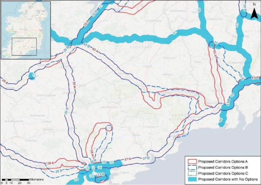
Table 39. Appraisal Relating to Corridor 39 Cork to Limerick (west of M7)
Figure B10: Map of corridor options 39 and 40
| Option A | B |
|---|---|
| = | = |
| = | = |
| = | = |
| = | = |
SEA Theme Summary of the Potential Effects Associated with Corridor 39 Cork to Limerick
Options A & B: Options A and B traverse a similar route with the exception of a divergence Biodiversity between Ballycarrane and Limerick. The following designated sites are similar to both options: Blarney Bog pNHA, Blarney Castle Woods pNHA, Ardamadane Wood pNHA, Blackwater River (Cork/Waterford) SAC, Tory Hill SAC and pNHA, Adare Woodlands pNHA, Loughmore Common Turlough pNHA, Inner Shannon Estuary - South Shore pNHA, River Shannon and River Fergus Estuaries SPA, and Lower River Shannon SAC. These designated sites and key sensitivities associated with the designations would need to be considered further when determining the final route during scheme development. Land take requirements are not known at this stage; however, it is anticipated the route would utilise existing infrastructure where practicable.
Population and Human Health
The corridor options would link the city of Cork (population c.208,670) with Limerick (population c.94,200) via Blarney population c.2,540), Mallow (population c.12,460), Rathluirc (Charleville) (population c.3,920) and Croom (population c.1,160). The options will support accessibility to the services, facilities and amenities and job opportunities available in these settlements. In this respect an enhancement of accessibility by active travel modes will promote social inclusion and the quality of life of residents and support health and wellbeing. The corridor options also have the potential to bring benefits for the visitor economy along the routes and support community vitality.
Land and Soils Option A: Land use along the proposed corridor / within the area is variable and includes areas
of urban fabric (artificial surfaces) in Limerick City, Mallow and Cork City and areas of pastures (agricultural areas) and non-irrigated arable land (agricultural areas) as per CORINE 2018. Should the route primarily involve the reallocation of road space / historic rail line, loss of land and loss of productive agricultural land is unlikely to be significant. Option B: Land use along the proposed corridor / within the area is variable and includes areas of urban fabric (artificial surfaces) in Limerick City, Mallow and Cork City and areas of pastures (agricultural areas) and non-irrigated arable land (agricultural areas) as per CORINE 2018. Should the route primarily involve the reallocation of road space / historic rail line, loss of land and loss of productive agricultural land is unlikely to be significant.
Options A & B: Several watercourses occur along the route of the proposed corridor, including Water the River Maigue, River Loobagh, River Awbeg, River Blackwater, River Martin, River Blarney and River Bride (Blackwater). The WFD status of these watercourses ranges between ‘good’
Appendix B: Corridor option assessment tables
National Cycle Network SEA Environmental Report (Updated)
Option
SEA Theme Summary of the Potential Effects Associated with Corridor 39 Cork to Limerick A B
| and ‘poor’ during the 2013-2018 monitoring period. The watercourses within the proposed corridor ranges from ‘at risk’ to ‘under review’. | ||
|---|---|---|
| Air Quality Options A & B: The route occurs in an area considered to be of ‘Good’ air quality. The route will provide a safe cycle route between Limerick City and Cork City. This will promote a modal shift to active modes of travel which will in turn support ongoing improvements to air quality in the area. | = | = |
| Climate The development of the corridor options as part of the NCN would promote a shift to active Change modes of travel from higher emission modes, including the private car. This will support a limitation of greenhouse gas emissions from transport. The corridor options may cross (and potentially negatively/positively impact on) areas of flood risk. Whilst impacts on flood risk, and, more broadly, climate change adaptation, depends on the detailed route of the corridor and scheme design, there would be a need to ensure that the delivery of the corridor options supports the resilience of the local area to the potential effects of climate change. | = | = |
| Cultural Option A: A range of cultural heritage assets are present within the proposed corridor, such as Heritage a burnt mound (LI013-170----), bridge (Reg. No. 21901241), burial ground (LI021-020----), bridges (Reg. No. 21902134) and (Reg. No. 21903107) and (Reg. No. 21903111) and (Reg. No. 21904705) and (Reg. No. 20904206) and (Reg. No. 20858007) and railway station (CO074- 117----). Given part of the proposed corridor is located along a historic railway line, sensitive development of the corridor as a cycle route offers the potential for the rejuvenation and enhanced enjoyment of this heritage asset. However, the proposed corridor also has the potential to impact on the setting of other cultural heritage assets (e.g., archaeological remains) which may occur along the proposed corridor. Option B: A range of cultural heritage assets are present within the proposed corridor, such as a bridge (Reg. No. 21901241) bridge (Reg. No. 21901241), burial ground (LI021-020----), bridges (Reg. No. 21902134) and (Reg. No. 21903107) and (Reg. No. 21903111) and (Reg. No. 21904705) and (Reg. No. 20904206) and (Reg. No. 20858007) and railway station (CO074- 117----). Given part of the proposed corridor is located along a historic railway line, sensitive development of the corridor as a cycle route offers the potential for the rejuvenation and enhanced enjoyment of this heritage asset. However, the proposed corridor also has the potential to impact on the setting of other cultural heritage assets (e.g., archaeological remains) which may occur along the proposed corridor. | 1 | 2 |
| Landscape The corridor options, given they largely follow existing transport corridors, are unlikely to lead to significant impacts on landscape character. They also offer opportunities to enhance the quality of the public realm, if high quality design and layouts are integrated within subsequent schemes. More broadly, the corridor options will support active travel modes, which are modes of transport with limited impacts on landscape character. Through promoting active travel modes, the corridor options will also support an enhanced understanding and enjoyment of the special qualities and intrinsic character of the landscape. | = | = |
Appendix B: Corridor option assessment tables AECOM
National Cycle Network
Table 40. Appraisal Relating to Corridor 40 Limerick to Waterford
SEA Theme Summary of the Potential Effects Associated with Corridor 40 Limerick to Waterford
| Biodiversity Options A & B: Options A and B diverge between Killeigh and Waterford. The following designated sites similarly affect both corridor options, Lower River Shannon SAC, Bansha Wood pNHA, Lower River Suir SAC, Scaragh Wood pNHA, Marlfield Lake pNHA, Kilsheelin Lake pNHA, River Suir Below Carrick-On-Suir pNHA, Tibberaghny Marshes pNHA, and Lower River Suir (Coolfinn, Portlaw) pNHA. These designated sites and key sensitivities associated with the designations would need to be considered further when determining the final route during scheme development. Land take requirements are not known at this stage; however, it is anticipated the route would utilise existing infrastructure such as roads and cycleways where practicable (for example the Suir Blueway Greenway). | = | = |
|---|---|---|
| Population The corridor options would link Limerick (population c.94,200) with Waterford (population and Human c.53,500) via Tipperary (population c.4,980), Cahir (population c.3,600), Clonmel (population Health c.17,140) and Carrick-on-Suir (population c.5,770). The options will support accessibility to the services, facilities and amenities and job opportunities available in these settlements. In this respect an enhancement of accessibility by active travel modes will promote social inclusion and the quality of life of residents and support health and wellbeing. The corridor options also have the potential to bring benefits for the visitor economy along the routes and support community vitality. Given Option B takes a less direct route between these settlements, Option A performs more favourably in relation to accessibility. | 1 | 2 |
| Land and Soils Option A: Land use along the proposed corridor / within the area is variable and includes areas of urban fabric (artificial surfaces) in Limerick City, Tipperary town, Cahir, Ardfinnan, Clonmel, Carrick-on-Suir, Kilmacthomas and Waterford City and areas of pastures (agricultural areas) and non-irrigated arable land (agricultural areas) and forest (forest and semi-natural areas) as per CORINE 2018. Should the route primarily involve the reallocation of road space / recreational amenity infrastructure / historic rail line, loss of land and loss of productive agricultural land is unlikely to be significant. Should the route require some land-take (from agriculture), the impact to likely to be significant / uncertain. Option B: Land use along the proposed corridor / within the area is variable and includes areas of urban fabric (artificial surfaces) in Limerick City, Tipperary town, Cahir, Clonmel, Carrick-on-Suir and Waterford City and areas of pastures (agricultural areas) and non-irrigated arable land (agricultural areas) and forest (forest and semi-natural areas) as per CORINE 2018. Should the route primarily involve the reallocation of road space / historic rail line, loss of land and loss of productive agricultural land is unlikely to be significant. Should the route require some land-take (from agriculture), the impact to likely to be significant / uncertain. | = | = |
| Water Option A: Several watercourses occur along the route of the proposed corridor, including the River Groody, River Mulkear, River Aherlow, River Suir and River Clodiagh (Portlaw). The WFD status of these watercourses ranges between ‘good’ and ‘poor’ during the 2013-2018 monitoring period. The watercourses within the proposed corridor ranges from ‘at risk’ to ‘under review’. Option B: Several watercourses occur along the route of the proposed corridor, including the River Groody, River Mulkear, River Aherlow, River Suir, River Glasha and River Clodiagh (Portlaw). The WFD status of these watercourses ranges between ‘good’ and ‘poor’ during the 2013-2018 monitoring period. The watercourses within the proposed corridor ranges from ‘at risk’ to ‘under review’. | = | = |
| Air Quality Options A & B: The route occurs in an area considered to be of ‘Good’ air quality. The route will provide a safe cycle route between Limerick City and Waterford City. This will promote a modal shift to active modes of travel which will in turn support ongoing improvements to air quality in the area. | = | = |
| Climate The development of the corridor options as part of the NCN would promote a shift to active Change modes of travel from higher emission modes, including the private car. This will support a limitation of greenhouse gas emissions from transport. The corridor options may cross (and potentially negatively/positively impact on) areas of flood risk. Whilst impacts on flood risk, and, more broadly, climate change adaptation, depends on the detailed route of the corridor and scheme design, there would be a need to ensure that the delivery of the corridor options supports the resilience of the local area to the potential effects of climate change. | = | = |
Appendix B: Corridor option assessment tables
National Cycle Network SEA Environmental Report (Updated)
| Option A | B |
|---|---|
| 1 | 2 |
| = | = |
SEA Theme Summary of the Potential Effects Associated with Corridor 40 Limerick to Waterford
Option A: A range of cultural heritage assets are present within the proposed corridor, such as a barracks (Reg. No. 21518033), burial ground (LI014-026----), fulacht fia (LI014-144----), enclosure (LI024-021----), historic town (TS067-004----), ringfort 9 (TS067-079----), bridge (Reg. No. 22126003), enclosure (TS088-012----), bridges (Reg. No. 22120002) and (Reg. No. 22123027) and (Reg. No. 22900802). Given part of the proposed corridor is located along a river / blue way / historic railway line, sensitive development of the corridor as a cycle route offers the potential for the rejuvenation and enhanced enjoyment of this heritage asset. However, the proposed corridor also has the potential to impact on the setting of other cultural heritage assets (e.g., archaeological remains) which may occur along the proposed corridor. Option B: A range of cultural heritage assets are present within the proposed corridor, such as a barracks (Reg. No. 21518033), burial ground (LI014-026----), fulacht fia (LI014-144----), enclosure (LI024-021----), historic town (TS067-004----), enclosure (TS076-070003-), gate lodge (Reg. No. 22900204) and a church (WA003-057----). Given part of the proposed corridor is located along a historic railway line, sensitive development of the corridor as a cycle route offers the potential for the rejuvenation and enhanced enjoyment of this heritage asset. However, the proposed corridor also has the potential to impact on the setting of other cultural heritage assets (e.g., archaeological remains) which may occur along the proposed corridor. Option A is likely to perform more favourably in relation to this SEA theme, as it aligns along existing infrastructure (greenway / blueway corridor) and would rejuvenation and connect cultural heritage assets along this route.
Cultural Heritage
The corridor options, given they largely follow existing transport corridors, are unlikely to lead Landscape to significant impacts on landscape character. They also offer opportunities to enhance the quality of the public realm, if high quality design and layouts are integrated within subsequent schemes. More broadly, the corridor options will support active travel modes, which are modes of transport with limited impacts on landscape character. Through promoting active travel modes, the corridor options will also support an enhanced understanding and enjoyment of the special qualities and intrinsic character of the landscape.
Appendix B: Corridor option assessment tables AECOM
National Cycle Network
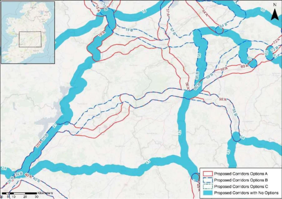
Table 41. Appraisal Relating to Corridor 41 Limerick to Kilkenny
Figure B11: Map of corridor options 41 and 42
SEA Theme Summary of the Potential Effects Associated with Corridor 41 Limerick to Kilkenny
Lower River Shannon SAC, Clare Glen SAC and pNHA, Slievefelim to Silvermines Mountains Biodiversity SPA, Derrygareen Heath pNHA, Lower River Suir SAC, Cabragh Wetlands pNHA, the Loughans SAC and pNHA, Spahill and Clomantagh Hill SAC and pNHA, River Nore SPA, River Barrow and River Nore SAC, Dunmore Complex pNHA, Newpark Marsh pNHA, and Lough Macask pNHA are all located within the corridor option. These designated sites and key sensitivities associated with the designations would need to be considered further when determining the final route during scheme development. Land take requirements are not known at this stage; however it is anticipated the route would utilise existing infrastructure such as along roads where practicable.
Population and Human Health
The corridor would link Limerick (population c.94,200) with Kilkenny (population c.26,510) via Annacotty (population c.2,930), Newport (population c.1,995), Thurles (population c.7,940) and Urlingford (population c.1,038). In this respect the corridor would support an enhancement of accessibility by active travel modes, promoting social inclusion and the quality of life of residents and supporting health and wellbeing. The corridor also has the potential to bring benefits for the visitor economy along the corridor and support community vitality.
Land and Soils
Land use along the proposed corridor / within the area is variable and includes areas of urban fabric (artificial surfaces) and industrial or commercial units (artificial surfaces) in Limerick City, Thurles, Urlingford and Kilkenny City and areas of pastures (agricultural areas), non-irrigated arable land (agricultural areas), forest and semi-natural areas (forest and semi-natural areas), mixed forest (forest and semi-natural areas) as per CORINE 2018. Should the route primarily involve the reallocation of road space, loss of land and loss of productive agricultural land is unlikely to be significant.
Several watercourses occur along the route of the proposed corridor, including the River Water Shannon, River Annagh, River Owenbeg (Tipperary) and the River Nore. The WFD status of these watercourses ranges between ‘good’ and ‘poor’ during the 2013-2018 monitoring period. The watercourses within the proposed corridor ranges from ‘at risk’ to ‘under review’.
The route occurs in an area considered to be of ‘Good’ air quality. The route will provide a safe Air Quality cycle route between Limerick City and Kilkenny City. This will promote a modal shift to active modes of travel which will in turn support ongoing improvements to air quality in the area.
Appendix B: Corridor option assessment tables
National Cycle Network SEA Environmental Report (Updated)
SEA Theme Summary of the Potential Effects Associated with Corridor 41 Limerick to Kilkenny Impact
The development of the corridor as part of the NCN would promote a shift to active modes of travel from higher emission modes, including the private car. This will support a limitation of greenhouse gas emissions from transport. The corridor may cross (and potentially negatively/positively impact on) areas of flood risk. Whilst impacts on flood risk, and, more broadly, climate change adaptation, depends on the detailed route of the corridor and scheme design, there would be a need to ensure that the delivery of the corridor supports the resilience of the local area to the potential effects of climate change.
Positive
A range of cultural heritage assets are present within the proposed corridor, such as a house (Reg. No. 21821005), bridge (TN037-001----), fulacht fia (TN037-033----), bridges (Reg. No. 22403905) and (Reg. No. 22312052), ringfort (TS042-026----), gardens (KK019-026208-) and a bridge (Reg. No. 12004007). The development of the cycle corridor offers the potential for the rejuvenation and enhanced enjoyment of cultural heritage assets. However, the proposed corridor also has the potential to impact on the setting of archaeological assets which occur along the proposed corridor.
Uncertain
The proposed corridor, given it is likely to follow existing transport infrastructure, is unlikely to lead Landscape to significant impacts on landscape character. It also offers opportunities to enhance the quality of the public realm, if high quality design and layouts are integrated within subsequent schemes. More broadly, the implementation of the corridor will support active travel modes, which are modes of transport with limited impacts on landscape character. Through promoting active travel modes, the corridor also offers opportunities to support an enhanced understanding and enjoyment of the special qualities and intrinsic character of the landscape in the vicinity of the corridor.
Positive
Appendix B: Corridor option assessment tables AECOM
National Cycle Network
Table 42. Appraisal Relating to Corridor 42 Kilkenny to Portlaoise
SEA Theme Summary of the Potential Effects Associated with Corridor 42 Kilkenny to Portlaoise
| Biodiversity The River Barrow and River Nore SAC, River Nore SPA, Dunmore Complex pNHA, Newpark Marsh pNHA, Ardaloo Fen pNHA, Inchbeg pNHA, River Nore/Abbeyleix Woods Complex pNHA, Lisbigney Bog SAC and pNHA, and Ridge of Portlaoise pNHA are all located within the corridor option. These designated sites and key sensitivities associated with the designations would need to be considered further when determining the final route during scheme development. Land take requirements are not known at this stage; however it is anticipated the route would utilise existing infrastructure such as along roads where practicable. | Uncertain |
|---|---|
| Population The corridor would link Kilkenny (population c.26,510) with Portlaoise (population c.22,050) and Human via Ballyragget (population c.1,080) and Abbeyleix (population c.1,770). In this respect the Health corridor would support an enhancement of accessibility by active travel modes, promoting social inclusion and the quality of life of residents and supporting health and wellbeing. The corridor also has the potential to bring benefits for the visitor economy along the corridor and support community vitality. | Positive |
| Land and Soils Land use along the proposed corridor / within the area is variable and includes areas of urban fabric (artificial surfaces) in Portlaoise and Kilkenny City and areas of pastures (agricultural areas), non-irrigated arable land (agricultural areas), peat bogs (wetland), mixed forest (forest and semi-natural areas) as per CORINE 2018. Should the route primarily involve the reallocation of road space / historic rail line, loss of land and loss of productive agricultural land is unlikely to be significant. | Uncertain |
| Water Several watercourses occur along the route of the proposed corridor, including the River Triogue and River Nore. The WFD status of these watercourses ranges between ‘good’ and ‘poor’ during the 2013-2018 monitoring period. The watercourses within the proposed corridor ranges from ‘at risk’ to ‘under review’. | Uncertain |
| Air Quality The route occurs in an area considered to be of ‘Good’ air quality. The route will provide a safe cycle route between Portlaoise and Kilkenny City. This will promote a modal shift to active modes of travel which will in turn support ongoing improvements to air quality in the area. | Positive |
| Climate The development of the corridor as part of the NCN would promote a shift to active modes of Change travel from higher emission modes, including the private car. This will support a limitation of greenhouse gas emissions from transport. The corridor may cross (and potentially negatively/positively impact on) areas of flood risk. Whilst impacts on flood risk, and, more broadly, climate change adaptation, depends on the detailed route of the corridor and scheme design, there would be a need to ensure that the delivery of the corridor supports the resilience of the local area to the potential effects of climate change. | Positive |
| Cultural A range of cultural heritage assets are present within the proposed corridor, such as a burial Heritage mound (LA023-061----), fountain (Reg. No. 12900718), bridge (Reg. No. 12303024) and a bridge (Reg. No. 12004004). Given part of the proposed corridor is located along a historic railway line, sensitive development of the corridor as a cycle route offers the potential for the rejuvenation and enhanced enjoyment of this heritage asset. However, the proposed corridor also has the potential to impact on the setting of other cultural heritage assets (e.g., archaeological remains) which may occur along the proposed corridor. | Uncertain |
| Landscape The proposed corridor, given it is likely to follow existing transport infrastructure, is unlikely to lead to significant impacts on landscape character. It also offers opportunities to enhance the quality of the public realm, if high quality design and layouts are integrated within subsequent schemes. More broadly, the implementation of the corridor will support active travel modes, which are modes of transport with limited impacts on landscape character. Through promoting active travel modes, the corridor also offers opportunities to support an enhanced understanding and enjoyment of the special qualities and intrinsic character of the landscape in the vicinity of the corridor. | Positive |
Appendix B: Corridor option assessment tables
National Cycle Network
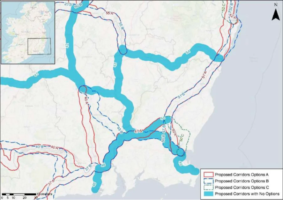
Table 43. Appraisal Relating to Corridor 43 Kilkenny to Carlow
Figure B12: Map of corridor options 43, 44, 45, 46, 47, 48 and 49
SEA Theme Summary of the Potential Effects Associated with Corridor 43 Kilkenny to Carlow
The River Nore SPA, River Barrow and River Nore SAC, Newpark Marsh pNHA, Biodiversity Archersgrove pNHA, Ballymoon Esker pNHA, and Cloghristick Wood pNHA occur within the corridor. These designated sites and key sensitivities associated with the designations would need to be considered further when determining the final route during scheme development. Land take requirements are not known at this stage; however, it is anticipated the route would utilise existing infrastructure such as along roads and cycleways (for example East Kilkenny Cycle Route) where practicable.
Population and Human Health
The corridor would link Kilkenny (population c.26,510) with Carlow (population c.24,270) via Muinebeag (Bagenalstown) (population c.2,840). In this respect the corridor would support an enhancement of accessibility by active travel modes, promoting social inclusion and the quality of life of residents and supporting health and wellbeing. The corridor also has the potential to bring benefits for the visitor economy along the corridor and support community vitality.
Land use along the proposed corridor / within the area is variable and includes areas of Land and Soils urban fabric (artificial surfaces) and industrial or commercial units (artificial surfaces) in Kilkenny City, Muine Beg and Carlow and areas of pastures (agricultural areas), nonirrigated arable land (agricultural areas) as per CORINE 2018. Should the route primarily involve the reallocation of road space / historic rail line, loss of land and loss of productive agricultural land is unlikely to be significant.
Several watercourses occur along the route of the proposed corridor, including the River Water Nore, River Gowran and the River Barrow. The WFD status of these watercourses ranges between ‘good’ and ‘poor’ during the 2013-2018 monitoring period. The watercourses within the proposed corridor ranges from ‘at risk’ to ‘under review’.
The route occurs in an area considered to be of ‘Good’ air quality. The route will provide a Air Quality safe cycle route between Kilkenny City and Carlow. This will promote a modal shift to active modes of travel which will in turn support ongoing improvements to air quality in the area.
Appendix B: Corridor option assessment tables
National Cycle Network SEA Environmental Report (Updated)
SEA Theme Summary of the Potential Effects Associated with Corridor 43 Kilkenny to Carlow Impact
The development of the corridor as part of the NCN would promote a shift to active modes Climate Change of travel from higher emission modes, including the private car. This will support a limitation of greenhouse gas emissions from transport. The corridor may cross (and potentially negatively/positively impact on) areas of flood risk. Whilst impacts on flood risk, and, more broadly, climate change adaptation, depends on the detailed route of the corridor and scheme design, there would be a need to ensure that the delivery of the corridor supports the resilience of the local area to the potential effects of climate change.
Positive
Cultural Heritage A range of cultural heritage assets are present within the proposed corridor, such as a
bridge (Reg. No. 12309004), house (Reg. No. 12402001), castle (KK021-027----) and a lock (Reg. No. 103007030). Given part of the proposed corridor is located along a historic railway line, sensitive development of the corridor as a cycle route offers the potential for the rejuvenation and enhanced enjoyment of this heritage asset. However, the proposed corridor also has the potential to impact on the setting of other cultural heritage assets (e.g., archaeological remains) which may occur along the proposed corridor.
Uncertain
The proposed corridor, given it is likely to follow existing transport infrastructure, is unlikely Landscape to lead to significant impacts on landscape character. It also offers opportunities to enhance the quality of the public realm, if high quality design and layouts are integrated within subsequent schemes. More broadly, the implementation of the corridor will support active travel modes, which are modes of transport with limited impacts on landscape character. Through promoting active travel modes, the corridor also offers opportunities to support an enhanced understanding and enjoyment of the special qualities and intrinsic character of the landscape in the vicinity of the corridor.
Positive
Appendix B: Corridor option assessment tables AECOM
National Cycle Network
Table 44. Appraisal Relating to Corridor 44 Kilkenny to Enniscorthy
Summary of the Potential Effects Associated with Corridor 44 Kilkenny to SEA Theme Enniscorthy
| Biodiversity The River Barrow and River Nore SAC, River Nore SPA, Newpark Marsh pNHA, Archersgrove pNHA, Blackstairs Mountains SAC and pNHA, Pollmounty River Valley pNHA, Barrow River Estuary pNHA, and Slaney River Valley SAC are located in the vicinity of the corridor. These designated sites and key sensitivities associated with the designations would need to be considered further when determining the final route during scheme development. Land take requirements are not known at this stage; however, it is anticipated the route would utilise existing infrastructure such as along roads and cycleways where practicable. | Uncertain |
|---|---|
| Population and The corridor would link Kilkenny (population c.26,510) with Enniscorthy (population Human Health c.11,380). The corridor would support an enhancement of accessibility by active travel modes to services and facilities in these settlements, promoting social inclusion and the quality of life of residents and supporting health and wellbeing. The corridor also has the potential to bring benefits for the visitor economy along the corridor and support community vitality. | Positive |
| Land and Soils Land use along the proposed corridor / within the area is variable and includes areas of urban fabric (artificial surfaces) and industrial or commercial units (artificial surfaces) in Kilkenny City and areas of pastures (agricultural areas), non-irrigated arable land (agricultural areas), coniferous forests (forest and semi-natural areas) as per CORINE 2018. Should the route primarily involve the reallocation of road space / railway line (greenway), loss of land and loss of productive agricultural land is unlikely to be significant. | Uncertain |
| Water Several watercourses occur along the route of the proposed corridor, including the River Nore, River Barrow, River Mountain (Carlow) and the River Aughnacrew. The WFD status of these watercourses ranges between ‘good’ and ‘poor’ during the 2013-2018 monitoring period. The watercourses within the proposed corridor ranges from ‘at risk’ to ‘under review’. | Uncertain |
| Air Quality The route occurs in an area considered to be of ‘Good’ air quality. The route will provide a safe cycle route in Kilkenny City. This will promote a modal shift to active modes of travel which will in turn support ongoing improvements to air quality in the area. | Positive |
| Climate Change The development of the corridor as part of the NCN would promote a shift to active modes of travel from higher emission modes, including the private car. This will support a limitation of greenhouse gas emissions from transport. The corridor may cross (and potentially negatively/positively impact on) areas of flood risk. Whilst impacts on flood risk, and, more broadly, climate change adaptation, depends on the detailed route of the corridor and scheme design, there would be a need to ensure that the delivery of the corridor supports the resilience of the local area to the potential effects of climate change. | Positive |
| Cultural Heritage A range of cultural heritage assets are present within the proposed corridor, such as a bridge (Reg. No. 12309004), house (Reg. No. 12402001), bridge (Reg. No. 10301904) and (Reg. No. 10302235), ringfort (WX030-012---) and a bridge (Reg. No. 15701943). Given part of the proposed corridor is located along a historic railway line, sensitive development of the corridor as a cycle route offers the potential for the rejuvenation and enhanced enjoyment of this heritage asset. However, the proposed corridor also has the potential to impact on the setting of other cultural heritage assets (e.g., archaeological remains) which may occur along the proposed corridor. | Uncertain |
| Landscape The proposed corridor, given it is likely to follow existing transport infrastructure, is unlikely to lead to significant impacts on landscape character. It also offers opportunities to enhance the quality of the public realm, if high quality design and layouts are integrated within subsequent schemes. More broadly, the implementation of the corridor will support active travel modes, which are modes of transport with limited impacts on landscape character. Through promoting active travel modes, the corridor also offers opportunities to support an enhanced understanding and enjoyment of the special qualities and intrinsic character of the landscape in the vicinity of the corridor. | Positive |
Appendix B: Corridor option assessment tables
National Cycle Network
Table 45. Appraisal Relating to Corridor 45 Kilkenny to Waterford
SEA Theme Summary of the Potential Effects Associated with Corridor 45 Kilkenny to Waterford
| Biodiversity Option A: Within the corridor are approximately two SACs, one SPA, and four pNHA/NHAs, including for the River Nore SPA, River Barrow and River Nore SAC Archersgrove pNHA, Lower River Suir SAC, Kilkeasy Bog pNHA and Grannyferry pNHA. These designated sites and key sensitivities associated with the designations would need to be considered further when determining the final route during scheme development. Land take requirements are not known at this stage; however, it is anticipated the route would utilise existing infrastructure such as along roads and cycleways (for example the South Kilkenny Cycle Loop) where practicable. Fewer designated sites are within the corridor for Option A than Option B. Option B: Within the corridor there are approximately three SAC, one SPA, and nine pNHA/NHA, including for example River Nore SPA, River Barrow and River Nore SAC Archersgrove pNHA, Lower River Suir SAC, Thomastown Quarry SAC, Thomastown pNHA, Barrow River Estuary pNHA, and Oaklands Wood pNHA. These designated sites and key sensitivities associated with the designations would need to be considered further when determining the final route during scheme development. Land take requirements are not known at this stage; however it is anticipated the route would utilise existing infrastructure such as along roads and cycleways (for example the East Kilkenny Cycle Route and the Southeast Greenway) where practicable. | 1 | 2 |
|---|---|---|
| Population The corridor options would link Kilkenny (population c.26,510) with Waterford (population and Human c.53,500). Option B would also link Thomastown (population c.2,445) and New Ross Health (population c.8,040). The options will support accessibility to the services, facilities and amenities and job opportunities available in these settlements. In this respect an enhancement of accessibility by active travel modes will promote social inclusion and the quality of life of residents and support health and wellbeing. The corridor options also have the potential to bring benefits for the visitor economy along the routes and support community vitality. Given the corridor option links two additional settlements, Option B performs better in relation to the SEA theme (although Option A brings benefits through comprising a more direct corridor between Kilkenny and Waterford). | 2 | 1 |
| Land and Option A: Land use along the proposed corridor / within the area is variable and includes areas Soils of urban fabric (artificial surfaces) in Kilkenny City and Waterford City and areas of pastures (agricultural areas) and non-irrigated arable land (agricultural areas) as per CORINE 2018. Should the route primarily involve the reallocation of road space, loss of land and loss of productive agricultural land is unlikely to be significant. Option B: Land use along the proposed corridor / within the area is variable and includes areas of urban fabric (artificial surfaces) in Kilkenny City, Bennettsbridge, Thomastown, New Ross and Waterford City and areas of pastures (agricultural areas) and non-irrigated arable land (agricultural areas) as per CORINE 2018. Should the route primarily involve the reallocation of road space, use existing infrastructure, loss of land and loss of productive agricultural land is unlikely to be significant. | = | = |
| Water Option A: Several watercourses occur along the route of the proposed corridor, including the River Nore, Stonyford Stream, Little Arrgile, River Blackwater. The WFD status of these watercourses ranges between ‘good’ and ‘poor’ during the 2013-2018 monitoring period. The watercourses within the proposed corridor ranges from ‘at risk’ to ‘under review’. Option B: Several watercourses occur along the route of the proposed corridor, including the River Nore, River Rathgarvan, River Cliodagh and Barrow Estuary and Suir Estuary. The WFD status of these watercourses ranges between ‘good’ and ‘poor’ during the 2013-2018 monitoring period. The watercourses within the proposed corridor ranges from ‘at risk’ to ‘under review’. | = | = |
| Air Quality Options A & B: The route occurs in an area considered to be of ‘Good’ air quality. The route will provide a safe cycle route between Kilkenny City and Waterford City. This will promote a modal shift to active modes of travel which will in turn support ongoing improvements to air quality in the area. | = | = |
| Climate The development of the corridor options as part of the NCN would promote a shift to active Change modes of travel from higher emission modes, including the private car. This will support a limitation of greenhouse gas emissions from transport. Option B, through linking two additional settlements, will however bring additional benefits in relation to this element of climate change mitigation. The corridor options may cross (and potentially negatively/positively impact on) areas of flood risk. Whilst impacts on flood risk, and, more broadly, climate change adaptation, depends on the detailed route of the corridor and scheme design, there would be a need to ensure that the delivery of the corridor options supports the resilience of the local area to the potential effects of climate change. | 1 | 2 |
Appendix B: Corridor option assessment tables
National Cycle Network SEA Environmental Report (Updated)
| Option A | B |
|---|---|
| 2 | 1 |
| = | = |
SEA Theme Summary of the Potential Effects Associated with Corridor 45 Kilkenny to Waterford
Option A: A range of cultural heritage assets are present within the proposed corridor, such as a concentric enclosure (KK023-016----), ring ditch (KK023-140----), bridge (Reg. No. 12321008) and a ritual site (KK036-030---). The development of the cycle corridor offers the potential for the rejuvenation and enhanced enjoyment of cultural heritage assets. However, the proposed corridor also has the potential to impact on the setting of archaeological assets which occur along the proposed corridor. Option B: A range of cultural heritage assets are present within the proposed corridor, such as an enclosure (KK019-114----), bridge (Reg. No. 12317011), holy (WX029-006----) and fulacht fia (KK046-012----). Given part of the proposed corridor is located along a historic railway line, sensitive development of the corridor as a cycle route offers the potential for the rejuvenation and enhanced enjoyment of this heritage asset. However, the proposed corridor also has the potential to impact on the setting of other cultural heritage assets (e.g., archaeological remains) which may occur along the proposed corridor. Option B is likely to perform more favourably in relation to this SEA theme, as it aligns along existing infrastructure (greenway / historic rail corridor) and would rejuvenation and connect cultural heritage assets along this route.
The corridor options, given they largely follow existing transport corridors, are unlikely to lead Landscape to significant impacts on landscape character. They also offer opportunities to enhance the quality of the public realm, if high quality design and layouts are integrated within subsequent schemes. More broadly, the corridor options will support active travel modes, which are modes of transport with limited impacts on landscape character. Through promoting active travel modes, the corridor options will also support an enhanced understanding and enjoyment of the special qualities and intrinsic character of the landscape.
Appendix B: Corridor option assessment tables AECOM
National Cycle Network
Table 46. Appraisal Relating to Corridor 46 Waterford to Tramore
SEA Theme Summary of the Potential Effects Associated with Corridor 46 Waterford to Tramore
| Biodiversity The route runs alongside the Lower River Suir SAC, Tramore Dunes and Backstrand SAC and pNHA, Tramore Back Strand SPA and passes through Kilbarry Bog pNHA. These designated sites and key sensitivities associated with the designations would need to be considered further when determining the final route during scheme development. Land take requirements are not known at this stage; however, it is anticipated the route would utilise existing infrastructure such as along roads where practicable. | Uncertain |
|---|---|
| Population and The corridor would link Waterford (population c.53,500) with Tranmore (population Human Health c.10,381). In this respect the corridor would support an enhancement of accessibility by active travel modes, promoting social inclusion and the quality of life of residents and supporting health and wellbeing. The corridor also has the potential to bring benefits for the visitor economy along the corridor and support community vitality. | Positive |
| Land and Soils Land use along the proposed corridor / within the area is variable and includes areas of urban fabric (artificial surfaces) and industrial or commercial units (artificial surfaces) in Waterford City and Tramore and areas of pastures (agricultural areas) as per CORINE 2018. Should the route primarily involve the reallocation of road space / historic rail line, loss of land and loss of productive agricultural land is unlikely to be significant. | Uncertain |
| Water Several watercourses occur along the route of the proposed corridor, including the River Suir, St. John’s River and the River Monloum. The WFD status of these watercourses ranges between ‘good’ and ‘poor’ during the 2013-2018 monitoring period. The watercourses within the proposed corridor ranges from ‘at risk’ to ‘under review’. | Uncertain |
| Air Quality The route occurs in an area considered to be of ‘Good’ air quality. The route will provide a safe cycle route between Waterford City and Tramore. This will promote a modal shift to active modes of travel which will in turn support ongoing improvements to air quality in the area. | Positive |
| Climate Change The development of the corridor as part of the NCN would promote a shift to active modes of travel from higher emission modes, including the private car. This will support a limitation of greenhouse gas emissions from transport. The corridor may cross (and potentially negatively/positively impact on) areas of flood risk. Whilst impacts on flood risk, and, more broadly, climate change adaptation, depends on the detailed route of the corridor and scheme design, there would be a need to ensure that the delivery of the corridor supports the resilience of the local area to the potential effects of climate change. | Positive |
| Cultural Heritage A range of cultural heritage assets are present within the proposed corridor, such as a windmill (WA009-036----), bridge (WA017-015----), bridge (Reg. No. 22901701) and a house (Reg. No. 22816129). Given part of the proposed corridor is located along a historic railway line, sensitive development of the corridor as a cycle route offers the potential for the rejuvenation and enhanced enjoyment of this heritage asset. However, the proposed corridor also has the potential to impact on the setting of other cultural heritage assets (e.g., archaeological remains) which may occur along the proposed corridor. | Uncertain |
| Landscape The proposed corridor, given it is likely to follow existing transport infrastructure, is unlikely to lead to significant impacts on landscape character. It also offers opportunities to enhance the quality of the public realm, if high quality design and layouts are integrated within subsequent schemes. More broadly, the implementation of the corridor will support active travel modes, which are modes of transport with limited impacts on landscape character. Through promoting active travel modes, the corridor also offers opportunities to support an enhanced understanding and enjoyment of the special qualities and intrinsic character of the landscape in the vicinity of the corridor. | Positive |
Appendix B: Corridor option assessment tables
National Cycle Network
Table 47. Appraisal Relating to Corridor 47 Enniscorthy to Waterford
SEA Theme Summary of the Potential Effects Associated with Corridor 47 Enniscorthy to Waterford
| Biodiversity Options A & B: The route diverges between Palace West and Enniscorthy. Both corridors traverse or are located next to the Lower River Suir SAC, King’s Channel pNHA, Barrow River Estuary pNHA, River Barrow and River Nore SAC, Oaklands Wood pNHA, Slaney River Valley SAC and pNHA, and Wexford Harbour and Slobs SPA. These designated sites and key sensitivities associated with the designations would need to be considered further when determining the final route during scheme development. Land take requirements are not known at this stage; however, it is anticipated the route would utilise existing infrastructure such as along roads and cycleways (for example the Southeast Greenway) where practicable. | 1 | 2 |
|---|---|---|
| Population The corridor options would link Enniscorthy (population c.11,380) with Waterford (population and Human c.53,500) via New Ross (population c.8,040). Health The options will support accessibility to the services, facilities and amenities and job opportunities available in these settlements. In this respect an enhancement of accessibility by active travel modes will promote social inclusion and the quality of life of residents and support health and wellbeing. The corridor options also have the potential to bring benefits for the visitor economy along the routes and support community vitality. | = | = |
| Land and Option A: Land use along the proposed corridor / within the area is variable and includes areas Soils of urban fabric (artificial surfaces) in Enniscorthy, New Ross and Waterford City and areas of pastures (agricultural areas) and non-irrigated arable land (agricultural areas) as per CORINE 2018. Should the route primarily involve the reallocation of road space / historic railway, loss of land and loss of productive agricultural land is unlikely to be significant. Option B: Land use along the proposed corridor / within the area is variable and includes areas of urban fabric (artificial surfaces) in Enniscorthy, New Ross and Waterford City and areas of pastures (agricultural areas) and non-irrigated arable land (agricultural areas) as per CORINE 2018. Should the route primarily involve the reallocation of road space / historic railway, loss of land and loss of productive agricultural land is unlikely to be significant. | = | = |
| Water Option A: Several watercourses occur along the route of the proposed corridor, including the River Slaney, River Nore, Barrow Nore Estuary and the River Suir and Suir Estuary. The WFD status of these watercourses ranges between ‘good’ and ‘poor’ during the 2013-2018 monitoring period. The watercourses within the proposed corridor ranges from ‘at risk’ to ‘under review’. Option B: Several watercourses occur along the route of the proposed corridor, including the River Urrin, Clonmore River, River Aughnacrew, River Nore, River Suir and the Barrow Nore Estuary and Suir Estuary. The WFD status of these watercourses ranges between ‘good’ and ‘poor’ during the 2013-2018 monitoring period. The watercourses within the proposed corridor ranges from ‘at risk’ to ‘under review’. | = | = |
| Air Quality Options A & B: The route occurs in an area considered to be of ‘Good’ air quality. The route will provide a safe cycle route between Enniscorthy and Waterford City. This will promote a modal shift to active modes of travel which will in turn support ongoing improvements to air quality in the area. | = | = |
| Climate The development of the corridor options as part of the NCN would promote a shift to active modes Change of travel from higher emission modes, including the private car. This will support a limitation of greenhouse gas emissions from transport. The corridor options may cross (and potentially negatively/positively impact on) areas of flood risk. Whilst impacts on flood risk, and, more broadly, climate change adaptation, depends on the detailed route of the corridor and scheme design, there would be a need to ensure that the delivery of the corridor options supports the resilience of the local area to the potential effects of climate change. | = | = |
Appendix B: Corridor option assessment tables
National Cycle Network SEA Environmental Report (Updated)
| Option A | B |
|---|---|
| 2 | 1 |
| = | = |
SEA Theme Summary of the Potential Effects Associated with Corridor 47 Enniscorthy to Waterford
Option A: A range of cultural heritage assets are present within the proposed corridor, such as a fulacht fia (KK046-012----), rock art (KK044-025----) and religious house (WX029-013007-) and a bridge (Reg. No. 15701943). Given part of the proposed corridor is located along a historic railway line, sensitive development of the corridor as a cycle route offers the potential for the rejuvenation and enhanced enjoyment of this heritage asset. However, the proposed corridor also has the potential to impact on the setting of other cultural heritage assets (e.g., archaeological remains) which may occur along the proposed corridor. Option B: A range of cultural heritage assets are present within the proposed corridor, such as a fulacht fia (KK046-012----), rock art (KK044-025----), fulacht fia (WX030-094----), ringfort (WX030-016----) and a railway station (Reg. No. 15703101). Given part of the proposed corridor is located along a historic railway line, sensitive development of the corridor as a cycle route offers the potential for the rejuvenation and enhanced enjoyment of this heritage asset. However, the proposed corridor also has the potential to impact on the setting of other cultural heritage assets (e.g., archaeological remains) which may occur along the proposed corridor. Option B is likely to perform more favourably in relation to this SEA theme, as it aligns along existing infrastructure (railway) and would rejuvenation and connect cultural heritage assets along this route.
The corridor options, given they largely follow existing transport corridors, are unlikely to lead to Landscape significant impacts on landscape character. They also offer opportunities to enhance the quality of the public realm, if high quality design and layouts are integrated within subsequent schemes. More broadly, the corridor options will support active travel modes, which are modes of transport with limited impacts on landscape character. Through promoting active travel modes, the corridor options will also support an enhanced understanding and enjoyment of the special qualities and intrinsic character of the landscape.
Appendix B: Corridor option assessment tables AECOM
National Cycle Network
Table 48. Appraisal Relating to Corridor 48 Waterford to Wexford
SEA Theme Summary of the Potential Effects Associated with Corridor 48 Waterford to Wexford
| Biodiversity The route traverses the Lower River Suir SAC, King’s Channel pNHA, Barrow River Estuary pNHA, River Barrow and River Nore SAC, Oaklands Wood pNHA, and Slaney River Valley SAC and pNHA, Wexford Slobs and Harbour pNHA, Wexford Harbour and Slobs SPA, Slaney River Valley SAC. These designated sites and key sensitivities associated with the designations would need to be considered further when determining the final route during scheme development. Land take requirements are not known at this stage; however, it is anticipated the route would utilise existing infrastructure such as along roads and cycleways (for example the Southeast Greenway) where practicable. | Uncertain |
|---|---|
| Population and The corridor would link Waterford (population c.53,500) with Wexford (population c.20,188) Human Health via New Ross (population c.8,040). In this respect the corridor would support an enhancement of accessibility to services and facilities by active travel modes, promoting social inclusion and the quality of life of residents and supporting health and wellbeing. The corridor also has the potential to bring benefits for the visitor economy along the corridor and support community vitality. | Positive |
| Land and Soils Land use along the proposed corridor / within the area is variable and includes areas of urban fabric (artificial surfaces) and industrial or commercial units (artificial surfaces) in Waterford City, New Ross and Wexford and areas of pastures (agricultural areas), non-irrigated arable land (agricultural areas), mixed forest (forest and semi-natural areas) and wetland (inland marshes) as per CORINE 2018. Should the route primarily involve the reallocation of road space / historic railway, loss of land and loss of productive agricultural land is unlikely to be significant. | Uncertain |
| Water Several watercourses occur along the route of the proposed corridor, including the River Luffany, River Nore, River Slaney, Clonmore River and the Barrow Nore Estuary and Suir Estuary. The WFD status of these watercourses ranges between ‘good’ and ‘poor’ during the 2013-2018 monitoring period. The watercourses within the proposed corridor ranges from ‘at risk’ to ‘under review’. | Uncertain |
| Air Quality The route occurs in an area considered to be of ‘Good’ air quality. The route will provide a safe cycle route between Waterford City and Wexford. This will promote a modal shift to active modes of travel which will in turn support ongoing improvements to air quality in the area. | Positive |
| Climate Change The development of the corridor as part of the NCN would promote a shift to active modes of travel from higher emission modes, including the private car. This will support a limitation of greenhouse gas emissions from transport. The corridor may cross (and potentially negatively/positively impact on) areas of flood risk. Whilst impacts on flood risk, and, more broadly, climate change adaptation, depends on the detailed route of the corridor and scheme design, there would be a need to ensure that the delivery of the corridor supports the resilience of the local area to the potential effects of climate change. | Positive |
| Cultural Heritage A range of cultural heritage assets are present within the proposed corridor, such as a fulacht fia (KK046-012----), rock art (KK044-025----), ringfort (WX030-016----). railway station (Reg. No. 15703101) and church (WX032-009001-). Given part of the proposed corridor is located along a historic railway line, sensitive development of the corridor as a cycle route offers the potential for the rejuvenation and enhanced enjoyment of this heritage asset. However, the proposed corridor also has the potential to impact on the setting of other cultural heritage assets (e.g., archaeological remains) which may occur along the proposed corridor. | Uncertain |
| Landscape The proposed corridor, given it is likely to follow existing transport infrastructure, is unlikely to lead to significant impacts on landscape character. It also offers opportunities to enhance the quality of the public realm, if high quality design and layouts are integrated within subsequent schemes. More broadly, the implementation of the corridor will support active travel modes, which are modes of transport with limited impacts on landscape character. Through promoting active travel modes, the corridor also offers opportunities to support an enhanced understanding and enjoyment of the special qualities and intrinsic character of the landscape in the vicinity of the corridor. | Positive |
Appendix B: Corridor option assessment tables
National Cycle Network SEA Environmental Report (Updated)
Table 49. Appraisal Relating to Corridor 49 Wexford to Rosslare Europort
Summary of the Potential Effects Associated with Corridor 49 Wexford to Rosslare SEA Theme Europort
| Biodiversity The Wexford Harbour and Slobs SPA and pNHA, Slaney River Valley SAC, and Carnsore Point SAC occur within the route corridor. These designated sites and key sensitivities associated with the designations would need to be considered further when determining the final route during scheme development. Land take requirements are not known at this stage; however, it is anticipated the route would utilise existing infrastructure such as along roads and cycleways where practicable. | Uncertain |
|---|---|
| Population The corridor would link Wexford (population c.20,188) with Rosslare Europort via Rosslare and Human (population c.1,620). This will support an enhancement of accessibility by active travel modes Health to the key employment centre of the port, as well as services and facilities available in Wexford, promoting social inclusion. The corridor also has the potential to bring benefits for the visitor economy and support sustainable tourism. | Positive |
| Land and Soils Land use along the proposed corridor / within the area is variable and includes areas of urban fabric (artificial surfaces) and industrial or commercial units (artificial surfaces and seaport) in Wexford, Rosslare and Rosslare Harbour and areas of pastures (agricultural areas), non- irrigated arable land (agricultural areas) as per CORINE 2018. Should the route primarily involve the reallocation of road space / railway, loss of land and loss of productive agricultural land is unlikely to be significant. | Uncertain |
| Water Several watercourses occur along the route of the proposed corridor, including the River Rathaspick, River Assaly and the River Milltown (Rosslare). The WFD status of these watercourses ranges between ‘good’ and ‘poor’ during the 2013-2018 monitoring period. The watercourses within the proposed corridor ranges from ‘at risk’ to ‘under review’. | Uncertain |
| Air Quality The route occurs in an area considered to be of ‘Good’ air quality. The route will provide a safe cycle route between Wexford and Rosslare Harbour. This will promote a modal shift to active modes of travel which will in turn support ongoing improvements to air quality in the area. | Positive |
| Climate The development of the corridor as part of the NCN would promote a shift to active modes of Change travel from higher emission modes, including the private car. This will support a limitation of greenhouse gas emissions from transport. The corridor may cross (and potentially negatively/positively impact on) areas of flood risk. Whilst impacts on flood risk, and, more broadly, climate change adaptation, depends on the detailed route of the corridor and scheme design, there would be a need to ensure that the delivery of the corridor supports the resilience of the local area to the potential effects of climate change. | Positive |
| Cultural A range of cultural heritage assets are present within the proposed corridor, such as a ritual site Heritage (WX037-038----), gate lodge (Reg. No. 15704265), moated site (WX042-092----) and a windmill (WX048-018----). Given part of the proposed corridor is located along a historic railway line, sensitive development of the corridor as a cycle route offers the potential for the rejuvenation and enhanced enjoyment of this heritage asset. However, the proposed corridor also has the potential to impact on the setting of other cultural heritage assets (e.g., archaeological remains) which may occur along the proposed corridor. | Uncertain |
| Landscape The proposed corridor, given it is likely to follow existing transport infrastructure, is unlikely to lead to significant impacts on landscape character. It also offers opportunities to enhance the quality of the public realm, if high quality design and layouts are integrated within subsequent schemes. More broadly, the implementation of the corridor will support active travel modes, which are modes of transport with limited impacts on landscape character. Through promoting active travel modes, the corridor also offers opportunities to support an enhanced understanding and enjoyment of the special qualities and intrinsic character of the landscape in the vicinity of the corridor. | Positive |
Appendix B: Corridor option assessment tables
National Cycle Network SEA Environmental Report (Updated)
Table 50. Appraisal Relating to Corridor 50 Enniscorthy to Wexford
Figure B13: Map of corridor options 50, 51, 52 and 54 (see Figure B14 for option 53)
| A | Option B | C |
|---|---|---|
| = | = | = |
| 2 | 2 | 1 |
| = | = | 2 |
SEA Theme Summary of the Potential Effects Associated with Corridor 50 Enniscorthy to Wexford
Biodiversity Options A, B & C: The Slaney River Valley pNHA, Wexford Harbour and Slobs SPA, Slaney
River Valley SAC, Wexford Slobs and Harbour pNHA, Wexford Harbour and Slobs SPA, and Slaney River Valley SAC are located within all option corridors. In addition, Screen Hills SAC and pNHA, and Ballyroe Fen and Lake pNHA are located within corridor C. These designated sites and key sensitivities associated with the designations would need to be considered further when determining the final route during scheme development. Land take requirements are not known at this stage; however, it is anticipated the route would utilise existing infrastructure such as along roads.
Population and Human Health
The corridor options would link Enniscorthy (population c.11,380) with Wexford (population c.20,188). Option C would also link Castlebridge (population c.1,840). The options will support accessibility to the services, facilities and amenities and job opportunities available in these settlements. In this respect an enhancement of accessibility by active travel modes will promote social inclusion and the quality of life of residents and support health and wellbeing. The corridor options also have the potential to bring benefits for the visitor economy along the routes and support community vitality. Given Option C would also link Castlebridge, Option C is slightly better performing in relation to this SEA theme than Options A and B.
Land and Soils
Option A: Land use along the proposed corridor / within the area is variable and includes areas of urban fabric (artificial surfaces) in Enniscorthy, Ollagate and Wexford town and areas of pastures (agricultural areas), inland marshes (wetland), construction site and non-irrigated arable land (agricultural areas) as per CORINE 2018. Should the route primarily involve the reallocation of road space, loss of land and loss of productive agricultural land is unlikely to be significant. Option B: Land use along the proposed corridor / within the area is variable and includes areas of urban fabric (artificial surfaces) in Enniscorthy and Wexford town and areas of pastures (agricultural areas), inland marshes (wetland) and non-irrigated arable land (agricultural areas) as per CORINE 2018. Should the route primarily involve the reallocation of road space, loss of land and loss of productive agricultural land is unlikely to be significant. Option C: Land use along the proposed corridor / within the area is variable and includes areas of urban fabric (artificial surfaces) in Enniscorthy, Castlebridge and Wexford town and areas of
Appendix B: Corridor option assessment tables
National Cycle Network SEA Environmental Report (Updated)
Option
SEA Theme Summary of the Potential Effects Associated with Corridor 50 Enniscorthy to Wexford A B C
| pastures (agricultural areas), inland marshes (wetland) and non-irrigated arable land (agricultural areas) as per CORINE 2018. Should the route primarily involve the reallocation of road space, loss of land and loss of productive agricultural land is unlikely to be significant. Option C would potentially require more land-take for this route option. Option A & B are more likely to perform more favourably in relation to this SEA theme as they align more along existing infrastructure (roads) and would require less land-take (from agriculture). | |||
|---|---|---|---|
| Water Option A: The watercourse along the route of the proposed corridor is the River Slaney and the Slaney Estuary. The WFD status of this watercourse ranges between ‘moderate’ and ‘poor’ during the 2013-2018 monitoring period. The watercourses within the proposed corridor ranges from ‘at risk’ to ‘under review’. Option B: Several watercourses occur along the route of the proposed corridor, including the River Slaney, Slaney Estuary, Clonmore River and the Tinnokilla Stream. The WFD status of these watercourses ranges between ‘good’ and ‘poor’ during the 2013-2018 monitoring period. The watercourses within the proposed corridor ranges from ‘at risk’ to ‘under review’. Option C: Several watercourses occur along the route of the proposed corridor, including the River Slaney, Slaney Estuary and the River Sow. The WFD status of these watercourses ranges between ‘good’ and ‘poor’ during the 2013-2018 monitoring period. The watercourses within the proposed corridor ranges from ‘at risk’ to ‘under review’. | = | = | = |
| Air Quality Options A & B & C: The route occurs in an area considered to be of ‘Good’ air quality. The route will provide a safe cycle route between Enniscorthy and Wexford town. This will promote a modal shift to active modes of travel which will in turn support ongoing improvements to air quality in the area. | = | = | = |
| Climate The development of the corridor options as part of the NCN would promote a shift to active Change modes of travel from higher emission modes, including the private car. This will support a limitation of greenhouse gas emissions from transport. Option C, through also linking Castlebridge, will however bring additional benefits in relation to this element of climate change mitigation. The corridor options may cross (and potentially negatively/positively impact on) areas of flood risk. Whilst impacts on flood risk, and, more broadly, climate change adaptation, depends on the detailed route of the corridor and scheme design, there would be a need to ensure that the delivery of the corridor options supports the resilience of the local area to the potential effects of climate change. | 2 | 2 | 1 |
| Cultural Option A: A range of cultural heritage assets are present within the proposed corridor, such as Heritage a castle tower (WX037-027—), ringfort (WX032-029----), and a house (Reg. No. 15603200). The development of the cycle corridor offers the potential for the rejuvenation and enhanced enjoyment of cultural heritage assets. However, the proposed corridor also has the potential to impact on the setting of archaeological assets which occur along the proposed corridor. Option B: A range of cultural heritage assets are present within the proposed corridor, such as a castle tower (WX037-027—), bridges (Reg. No. 15703218), and (Reg. No. 15702613). The development of the cycle corridor offers the potential for the rejuvenation and enhanced enjoyment of cultural heritage assets. However, the proposed corridor also has the potential to impact on the setting of archaeological assets which occur along the proposed corridor. Option C: A range of cultural heritage assets are present within the proposed corridor, such as a bridge (Reg. No. 15501001), malt house (Reg. No. 15614019) and a gate lodge (Reg. No. 15702640). The development of the cycle corridor offers the potential for the rejuvenation and enhanced enjoyment of cultural heritage assets. However, the proposed corridor also has the potential to impact on the setting of archaeological assets which occur along the proposed corridor. | = | = | = |
| Landscape The corridor options, given they largely follow existing transport corridors, are unlikely to lead to significant impacts on landscape character. They also offer opportunities to enhance the quality of the public realm, if high quality design and layouts are integrated within subsequent schemes. More broadly, the corridor options will support active travel modes, which are modes of transport with limited impacts on landscape character. Through promoting active travel modes, the corridor options will also support an enhanced understanding and enjoyment of the special qualities and intrinsic character of the landscape. | = | = | = |
Appendix B: Corridor option assessment tables AECOM
National Cycle Network
Table 51. Appraisal Relating to Corridor 51 Enniscorthy to Wicklow
Summary of the Potential Effects Associated with Corridor 51 Enniscorthy to SEA Theme Wicklow
| Biodiversity Option A: The route diverges between Arklow and Wicklow. Option A is located further away from designated sites where it diverges from Option B. Within the corridor there are approximately three SACs, two SPAs, and ten pNHA/NHAs, including for example Slaney River Valley SAC and pNHA, Buckroney-Brittas Dunes and Fen SAC and pNHA, Wicklow Town Sites pNHA, the Murrough Wetlands SAC, and Glenealy Woods pNHA. These designated sites and key sensitivities associated with the designations would need to be considered further when determining the final route during scheme development. Land take requirements are not known at this stage; however it is anticipated the route would utilise existing infrastructure such as along roads. Option B: The route diverges between Arklow and Wicklow. Within the corridor there are approximately five SACs, two SPAs, and ten pNHA/NHAs, including for example Slaney River Valley SAC and pNHA, Buckroney-Brittas Dunes and Fen SAC and pNHA, Wicklow Town Sites pNHA, the Murrough Wetlands SAC, Magherabeg Dunes SAC and pNHA, and Wicklow Reef SAC. These designated sites and key sensitivities associated with the designations would need to be considered further when determining the final route during scheme development. Land take requirements are not known at this stage; however it is anticipated the route would utilise existing infrastructure such as along roads. | 1 | 2 |
|---|---|---|
| Population The corridor options would link Enniscorthy (population c.11,380) with Wicklow (population and Human c.13,160) via Ferns (population c.1,415), Gorey (population c.9,820) and Arklow (population Health c.13,160). Option A also links Rathnew (population c.3,370) The options will support accessibility to the services, facilities and amenities and job opportunities available in these settlements. In this respect an enhancement of accessibility by active travel modes will promote social inclusion and the quality of life of residents and support health and wellbeing. The corridor options also have the potential to bring benefits for the visitor economy along the routes and support community vitality. Whilst Option A would also link Rathnew, Option B has the potential to deliver additional benefits for the visitor economy given it runs alongside the coast. | = | = |
| Land and Option A: Land use along the proposed corridor / within the area is variable and includes Soils areas of urban fabric (artificial surfaces) in Enniscorthy, Gorey, Arklow and Wicklow town and areas of pastures (agricultural areas) a non-irrigated arable land (agricultural areas) as per CORINE 2018. Option B: Land use along the proposed corridor / within the area is variable and includes areas of urban fabric (artificial surfaces) in Enniscorthy, Gorey, Arklow, Ardanay and Wicklow town and areas of pastures (agricultural areas), non-irrigated arable land (agricultural areas) and inland marshes (wetland) as per CORINE 2018. Should the proposed routes primarily involve the reallocation of road space, loss of land and loss of productive agricultural land is unlikely to be significant. | = | = |
| Water Option A: Several watercourses occur along the route of the proposed corridor, including the River Slaney, Avoca Estuary, River Bann, River Banoge, River Inch, Ballyduff Stream, River Redcross and Rathnew Stream. The WFD status of these watercourses ranges between ‘good’ and ‘poor’ during the 2013-2018 monitoring period. The watercourses within the proposed corridor ranges from ‘at risk’ to ‘under review’. Option B: Several watercourses occur along the route of the proposed corridor, including the River Slaney, Avoca Estuary, River Inch, Templerainy Stream and the Three-mile Water stream. The WFD status of these watercourses ranges between ‘good’ and ‘poor’ during the 2013-2018 monitoring period. The watercourses within the proposed corridor ranges from ‘at risk’ to ‘under review’. | = | = |
| Air Quality Options A & B: The route occurs in an area considered to be of ‘Good’ air quality. The route will provide a safe cycle route between Enniscorthy and Wicklow town. This will promote a modal shift to active modes of travel which will in turn support ongoing improvements to air quality in the area. | = | = |
| Climate The development of the corridor options as part of the NCN would promote a shift to active Change modes of travel from higher emission modes, including the private car. This will support a limitation of greenhouse gas emissions from transport. The corridor options may cross (and potentially negatively/positively impact on) areas of flood risk. Whilst impacts on flood risk, and, more broadly, climate change adaptation, depends on the detailed route of the corridor and scheme design, there would be a need to ensure that the delivery of the corridor options supports the resilience of the local area to the potential effects of climate change. | = | = |
Appendix B: Corridor option assessment tables
National Cycle Network SEA Environmental Report (Updated)
Option
Summary of the Potential Effects Associated with Corridor 51 Enniscorthy to SEA Theme Wicklow
A B
| = | = |
|---|---|
| = | = |
Option A: A range of cultural heritage assets are present within the proposed corridor, such as a fulacht fia (WX020-095----), burial (WX020-001005-) and burnt mound (WI045-015----). The development of the cycle corridor offers the potential for the rejuvenation and enhanced enjoyment of cultural heritage assets. However, the proposed corridor also has the potential to impact on the setting of archaeological assets which occur along the proposed corridor. Option B: A range of cultural heritage assets are present within the proposed corridor, such as a fulacht fia (WX020-095----), burial (WX020-001005-) and a prehistoric site (WI036-027- ---). The development of the cycle corridor offers the potential for the rejuvenation and enhanced enjoyment of cultural heritage assets. However, the proposed corridor also has the potential to impact on the setting of archaeological assets which occur along the proposed corridor.
The corridor options, given they largely follow existing transport corridors, are unlikely to lead Landscape to significant impacts on landscape character. They also offer opportunities to enhance the quality of the public realm, if high quality design and layouts are integrated within subsequent schemes. More broadly, the corridor options will support active travel modes, which are modes of transport with limited impacts on landscape character. Through promoting active travel modes, the corridor options will also support an enhanced understanding and enjoyment of the special qualities and intrinsic character of the landscape.
Appendix B: Corridor option assessment tables AECOM
National Cycle Network
Table 52. Appraisal Relating to Corridor 52 Wicklow to Bray
SEA Theme Summary of the Potential Effects Associated with Corridor 52 Wicklow to Bray
| Biodiversity Options A, B & C: A number of designated sites are common to all three options. These are, Wicklow Head SPA and pNHA, Wicklow Town Sites pNHA, the Murrough SPA and pNHA, the Murrough Wetlands SAC, and Bray Head SAC and pNHA. The Glen of the Downs SAC and pNHA is common to Options A and C, while Devil’s Glen pNHA is located within the option C corridor only. These designated sites and key sensitivities associated with the designations would need to be considered further when determining the final route during scheme development. Option B runs along the coast and is located within the Murrough SPA and pNHA, and the Murrough Wetlands SAC, however this route could potentially utilise existing infrastructure along its route. Routes A and C are located further away from these designated sites. Land take requirements are not known at this stage; however it is anticipated the routes would utilise existing infrastructure such as roads and cycleways where practicable. | 2 | 3 | 1 |
|---|---|---|---|
| Population The corridor options would link Bray (population c.32,600) with Wicklow (population and Human c.13,160). Health Option A would also link the two towns with Rathnew (population c.3,370), Kilcoole (population c4,240) and Greystones-Delgany (population c.18,140), and Option C would also link the two towns with Rathnew (population c.3,370), Ashford (population c.1,425), Newtownmountkennedy (population c.2,835), Kilpedder (population c.1,255) and Greystones-Delgany (population c.18,140). Option B would run along the coast. The options will support accessibility to the services, facilities and amenities and job opportunities available in these settlements. In this respect an enhancement of accessibility by active travel modes will promote social inclusion and the quality of life of residents and support health and wellbeing. The corridor options also have the potential to bring benefits for the visitor economy along the routes and support community vitality. Whilst Option A and C would link more settlements, Option B has the potential to deliver additional benefits for the visitor economy given it runs along the coast. | = | = | = |
| Land and Option A: Land use along the proposed corridor / within the area is variable and includes Soils areas of urban fabric (artificial surfaces) in Wicklow Town, Kilcoole, Greystones and Bray and areas of pastures (agricultural areas), non-irrigated arable land (agricultural areas) and wetland (inland marshes) as per CORINE 2018. Should the route primarily involve the reallocation of road space, loss of land and loss of productive agricultural land is unlikely to be significant. Option B: Land use along the proposed corridor / within the area is variable and includes areas of urban fabric (artificial surfaces) in Wicklow Town, Greystones and Bray and areas of pastures (agricultural areas) and non-irrigated arable land (agricultural areas) and wetland (inland marshes) as per CORINE 2018. Should the route primarily lie within an existing railway corridor, loss of land and loss of productive agricultural land is unlikely to be significant. Option C: Land use along the proposed corridor / within the area is variable and includes areas of urban fabric (artificial surfaces) in Wicklow Town, Ashford, Newtownmount Kennedy, Greystones and Bray and areas of pastures (agricultural areas), non-irrigated arable land (agricultural areas) and wetland (inland marshes) as per CORINE 2018. Should the route primarily involve the reallocation of road space, loss of land and loss of productive agricultural land is unlikely to be significant. | = | = | = |
| Water Option A: Several watercourses occur along the route of the proposed corridor, including Rathnew Stream, Kilcoole Stream and Dargle River and Broad Lough. The WFD status of these watercourses ranges between ‘good’ and ‘poor’ during the 2013-2018 monitoring period. The watercourses within the proposed corridor ranges from ‘at risk’ to ‘under review’. Option B: Several watercourses occur along the route of the proposed corridor, including the River Vartry, Kilcoole Stream. Kilcool Marsh, Dargle River and Broad Lough. The WFD status of these watercourses ranges between ‘good’ and ‘poor’ during the 2013-2018 monitoring period. The watercourses within the proposed corridor ranges from ‘at risk’ to ‘under review’. Option C: Several watercourses occur along the route of the proposed corridor, including Rathnew Stream, River Vartry and Dargle River and Broad Lough. The WFD status of these watercourses ranges between ‘good’ and ‘poor’ during the 2013-2018 monitoring period. The watercourses within the proposed corridor ranges from ‘at risk’ to ‘under review’. | = | = | = |
| Air Quality Options A & B & C: The route occurs in an area considered to be of ‘Good’ air quality. The route will provide a safe cycle route between Wicklow Town and Bray. This will promote a modal shift to active modes of travel which will in turn support ongoing improvements to air quality in the area. | = | = | = |
Appendix B: Corridor option assessment tables
National Cycle Network SEA Environmental Report (Updated)
Option
SEA Theme Summary of the Potential Effects Associated with Corridor 52 Wicklow to Bray A B C
| Climate The development of the corridor options as part of the NCN would promote a shift to active Change modes of travel from higher emission modes, including the private car. This will support a limitation of greenhouse gas emissions from transport. The corridor options may cross (and potentially negatively / positively impact on) areas of flood risk. Whilst impacts on flood risk, and, more broadly, climate change adaptation, depends on the detailed route of the corridor and scheme design, there would be a need to ensure that the delivery of the corridor options supports the resilience of the local area to the potential effects of climate change. | = | = | = |
|---|---|---|---|
| Cultural Option A: A range of cultural heritage assets are present within the proposed corridor, such Heritage as an architectural feature (WI025-012005-), hotel (Reg. No. 16402506) and a house (Reg. No. 16400819). The development of the cycle corridor offers the potential for the rejuvenation and enhanced enjoyment of cultural heritage assets. However, the proposed corridor also has the potential to impact on the setting of archaeological assets which occur along the proposed corridor. Option B: A range of cultural heritage assets are present within the proposed corridor, such as a prehistoric site (WI019-038----), station house (Reg. No. 1640191) and a house (Reg. No. 16400819). Given part of the proposed corridor is located along a railway line, sensitive development of the corridor as a cycle route offers the potential for the rejuvenation and enhanced enjoyment of this heritage asset. However, the proposed corridor also has the potential to impact on the setting of other cultural heritage assets (e.g., archaeological remains) which may occur along the proposed corridor. Option C: A range of cultural heritage assets are present within the proposed corridor, such as a house (Reg. No. 16402512), ritual site (WI019-015----) and a house (Reg. No. 16400819). The development of the cycle corridor offers the potential for the rejuvenation and enhanced enjoyment of cultural heritage assets. However, the proposed corridor also has the potential to impact on the setting of archaeological assets which occur along the proposed corridor. Option B is likely to perform more favourably in relation to this SEA theme, as it aligns more along existing infrastructure (railway) and would rejuvenation and connect cultural heritage assets along this route. | = | 1 | = |
| Landscape The corridor options, given they largely follow existing transport corridors, are unlikely to lead to significant impacts on landscape character. They also offer opportunities to enhance the quality of the public realm, if high quality design and layouts are integrated within subsequent schemes. More broadly, the corridor options will support active travel modes, which are modes of transport with limited impacts on landscape character. Through promoting active travel modes, the corridor options will also support an enhanced understanding and enjoyment of the special qualities and intrinsic character of the landscape. | = | = | = |
Appendix B: Corridor option assessment tables AECOM
National Cycle Network
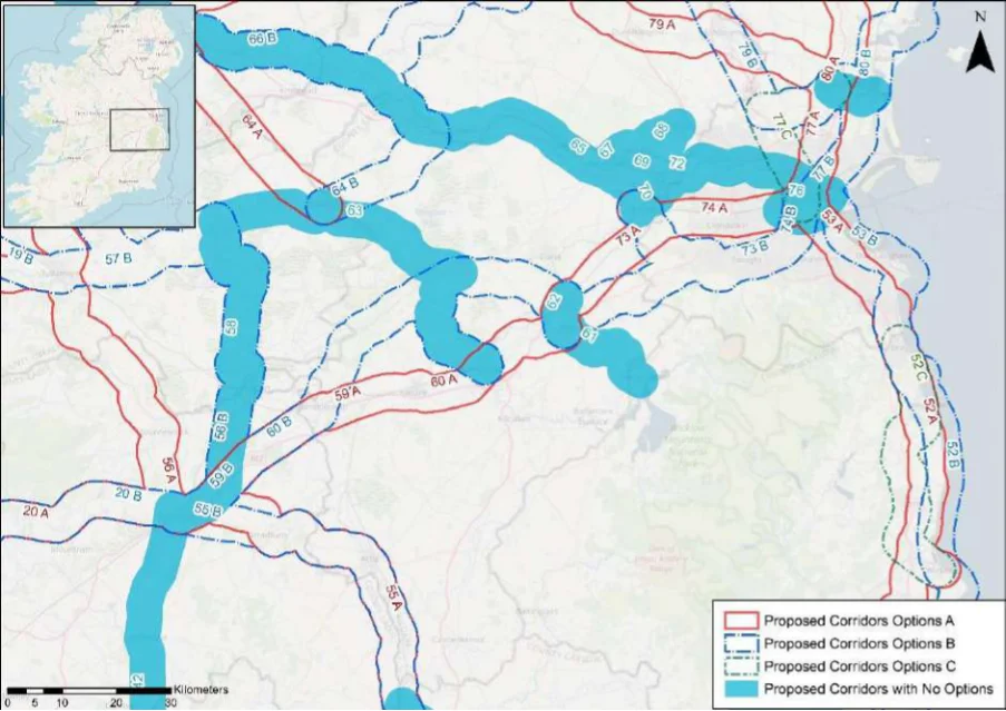
Table 53. Appraisal Relating to Corridor 53 Bray to Dublin
Figure B14: Map of corridor options 53 and 55 and 56 (see Figure B13 for option 54)
| Option A | B |
|---|---|
| 1 | 2 |
| 2 | 1 |
| = | = |
SEA Theme Summary of the Potential Effects Associated with Corridor 53 Bray to Dublin
Option A & B: The route diverges between Shankill and Dublin. Option B is located along the Biodiversity coastline where a number of designated sites are located, while Option A is slightly inland and situated further away from designated sites. The designated sites common to both options include Loughlinstown Woods pNHA, Dalkey Coastal Zone and Killiney Hill pNHA, South Dublin Bay SAC and pNHA, South Dublin Bay and River Tolka Estuary SPA, Grand Canal pNHA, and Royal Canal pNHA. Dalkey Islands SPA, and Rockabill to Dalkey Island SAC occur adjacent to Option B only. These designated sites and key sensitivities associated with the designations would need to be considered further when determining the final route during scheme development. Land take requirements are not known at this stage; however it is anticipated the routes would utilise existing infrastructure such as roads and cycleways where practicable.
Population and Human Health
The two options would both link Dublin with Bray, supporting accessibility via active modes of travels for the Dublin communities located along the routes. As such, the options will support accessibility to the services, facilities and amenities and job opportunities available in Dublin. In this respect an enhancement of accessibility by active travel modes will promote social inclusion and the quality of life of residents and support health and wellbeing. Option B, through running along the coastline of the southern part of Dublin Bay, may offer additional opportunities relating to tourism offer and the visitor economy.
Land and Soils Option A: Land use along the proposed corridor / within the area is variable and includes areas
of urban fabric (artificial surfaces) in Bray, Shankill and Dublin City and Suburbs and areas of pastures (agricultural areas) and non-irrigated arable land (agricultural areas) as per CORINE 2018. Should the route primarily involve the reallocation of road space, loss of land and loss of productive agricultural land is unlikely to be significant. Option B: Land use along the proposed corridor / within the area is variable and includes areas of urban fabric (artificial surfaces) in Bray and Dublin City and Suburbs and areas of pastures (agricultural areas) and non-irrigated arable land (agricultural areas) as per CORINE 2018. Should the route primarily involve the reallocation of road space, loss of land and loss of productive agricultural land is unlikely to be significant.
Appendix B: Corridor option assessment tables
National Cycle Network SEA Environmental Report (Updated)
Option
SEA Theme Summary of the Potential Effects Associated with Corridor 53 Bray to Dublin A B
| Water Option A: Several watercourses occur along the route of the proposed corridor, including the Dargle River, Shangahagh Stream, Carrickmines Stream, Brewery Stream, and the Grand Canal. The WFD status of these watercourses ranges between ‘moderate’ and ‘poor’ during the 2013-2018 monitoring period. The watercourses within the proposed corridor ranges from ‘at risk’ to ‘under review’. Option B: Several watercourses occur along the route of the proposed corridor, including the Dargle River, Kill of the Grange Stream, Brewery Stream, Dodder River and Grand Canal and the Liffey Estuary. The WFD status of these watercourses ranges between ‘moderate’ and ‘poor’ during the 2013-2018 monitoring period. The watercourses within the proposed corridor ranges from ‘at risk’ to ‘under review’. | = | = |
|---|---|---|
| Air Quality Option A & B: The route occurs in an area considered to be of ‘Good’ air quality. The route will provide a safe cycle route between Bray and Dublin City and Suburbs. This will promote a modal shift to active modes of travel which will in turn support ongoing improvements to air quality in the area. | = | = |
| Climate The development of the corridor options as part of the NCN would promote a shift to active Change modes of travel from higher emission modes, including the private car. This will support a limitation of greenhouse gas emissions from transport. The corridor options may cross (and potentially negatively/positively impact on) areas of flood risk. Whilst impacts on flood risk, and, more broadly, climate change adaptation, depends on the detailed route of the corridor and scheme design, there would be a need to ensure that the delivery of the corridor options supports the resilience of the local area to the potential effects of climate change. | = | = |
| Cultural Option A: A range of cultural heritage assets are present within the proposed corridor, such as Heritage a gate lodge (Reg. No. 60260162), bridge (Reg. No. 60260118) and an Ecclesiastical site (DU023-007----). The development of the cycle corridor offers the potential for the rejuvenation and enhanced enjoyment of cultural heritage assets, particularly in Dublin City and Suburbs. However, the proposed corridor also has the potential to impact on the setting of archaeological assets which occur along the proposed corridor. Option B: A range of cultural heritage assets are present within the proposed corridor, such as a gate lodge (Reg. No. 60260162), Martello tower (DU026-089----), quay (DU023-020004-) and a fort (DU023-052001-). The development of the cycle corridor offers the potential for the rejuvenation and enhanced enjoyment of cultural heritage assets, particularly along the coast. However, the proposed corridor also has the potential to impact on the setting of archaeological assets which occur along the proposed corridor. | = | = |
| Landscape The corridor options, given they largely follow existing transport corridors, are unlikely to lead to significant impacts on landscape character. They also offer opportunities to enhance the quality of the public realm, if high quality design and layouts are integrated within subsequent schemes. More broadly, the corridor options will support active travel modes, which are modes of transport with limited impacts on landscape character. Through promoting active travel modes, the corridor options will also support an enhanced understanding and enjoyment of the special qualities and intrinsic character of the landscape. | = | = |
Appendix B: Corridor option assessment tables AECOM
National Cycle Network
Table 54. Appraisal Relating to Corridor 54 Carlow to Arklow
SEA Theme Summary of the Potential Effects Associated with Corridor 54 Carlow to Arklow
| Biodiversity Between Carlow and Arklow the corridor traverses a number of designated sites, these are: Slaney River Valley SAC, Tomnafinnoge Wood pNHA, Avoca River Valley pNHA, and Arklow Town Marsh pNHA. These designated sites and key sensitivities associated with the designations would need to be considered further when determining the final route during scheme development. Land take requirements are not known at this stage; however it is anticipated the route would utilise existing infrastructure such as roads and cycleways where practicable. | Uncertain |
|---|---|
| Population and The corridor would link Carlow (population c.24,270) with Arklow (population c.20,188) via Human Health Tullow (population c.4,670) and Aughrim (population c.1,440). In this respect the corridor would support an enhancement of accessibility to services and facilities from communities along the route by active travel modes, promoting social inclusion and the quality of life of residents and supporting health and wellbeing. The corridor also has the potential to bring benefits for the visitor economy along the corridor and support community vitality. | Positive |
| Land and Soils Land use along the proposed corridor / within the area is variable and includes areas of urban fabric (artificial surfaces) and industrial or commercial units (artificial surfaces) in Carlow, Tullow and Arklow and areas of pastures (agricultural areas), non-irrigated arable land (agricultural areas), mixed forest (forest and semi-natural areas), forest and semi- natural areas (forest and semi-natural areas) as per CORINE 2018. Should the route primarily involve the reallocation of road space / historic railway, loss of land and loss of productive agricultural land is unlikely to be significant. | Uncertain |
| Water Several watercourses occur along the route of the proposed corridor, including the River Burren, River Slaney, Blacklion Stream, Derry Water River, Avoca River and Avoca Estuary. The WFD status of these watercourses ranges between ‘good’ and ‘poor’ during the 2013- 2018 monitoring period. The watercourses within the proposed corridor ranges from ‘at risk’ to ‘under review’. | Uncertain |
| Air Quality The route occurs in an area considered to be of ‘Good’ air quality. The route will provide a safe cycle route between Carlow and Arklow. This will promote a modal shift to active modes of travel which will in turn support ongoing improvements to air quality in the area. | Positive |
| Climate Change The development of the corridor as part of the NCN would promote a shift to active modes of travel from higher emission modes, including the private car. This will support a limitation of greenhouse gas emissions from transport. The corridor may cross (and potentially negatively/positively impact on) areas of flood risk. Whilst impacts on flood risk, and, more broadly, climate change adaptation, depends on the detailed route of the corridor and scheme design, there would be a need to ensure that the delivery of the corridor supports the resilience of the local area to the potential effects of climate change. | Positive |
| Cultural Heritage A range of cultural heritage assets are present within the proposed corridor, such as an enclosure (CW007-161----), fulacht fia (CW007-099----) and a castle (CW008-045002-) and a gate lodge (Reg. No. 16404312). Given part of the proposed corridor is located along a historic railway line, sensitive development of the corridor as a cycle route offers the potential for the rejuvenation and enhanced enjoyment of this heritage asset. However, the proposed corridor also has the potential to impact on the setting of other cultural heritage assets (e.g., archaeological remains) which may occur along the proposed corridor. | Uncertain |
| Landscape The proposed corridor, given it is likely to follow existing transport infrastructure, is unlikely to lead to significant impacts on landscape character. It also offers opportunities to enhance the quality of the public realm, if high quality design and layouts are integrated within subsequent schemes. More broadly, the implementation of the corridor will support active travel modes, which are modes of transport with limited impacts on landscape character. Through promoting active travel modes, the corridor also offers opportunities to support an enhanced understanding and enjoyment of the special qualities and intrinsic character of the landscape in the vicinity of the corridor. | Positive |
Appendix B: Corridor option assessment tables
National Cycle Network
Table 55. Appraisal Relating to Corridor 55 Carlow to Portlaoise
SEA Theme Summary of the Potential Effects Associated with Corridor 55 Carlow to Portlaoise
| Biodiversity Option A & B: Both routes are similar with the exception of a small divergence between Stradbally and Portlaoise. The route traverses or is adjacent to Ridge of Portlaoise pNHA, Dunamase Woods pNHA, Rock of Dunamase pNHA, Kilteale Hill pNHA, The Great Heath of Portlaoise pNHA, River Barrow and River Nore SAC, Stradbally Hill pNHA, Barrow Valley at Tankardstown Bridge pNHA, and Oakpark pNHA. These designated sites and key sensitivities associated with the designations would need to be considered further when determining the final route during scheme development. Land take requirements are not known at this stage; however, it is anticipated the routes would utilise existing infrastructure where practicable. | = | = |
|---|---|---|
| Population The corridor options would link Carlow (population c.24,270) with Portlaoise (population and Human c.22,050) via Athy (population c.9,680) and Stradbally (population c.1,350). Health The options will support accessibility to the services, facilities and amenities and job opportunities available in these settlements. In this respect an enhancement of accessibility by active travel modes will promote social inclusion and the quality of life of residents and support health and wellbeing. The corridor options also have the potential to bring benefits for the visitor economy along the routes and support community vitality. | = | = |
| Land and Soils Option A: Land use along the proposed corridor / within the area is variable and includes areas of urban fabric (artificial surfaces) in Carlow, Athy and Stradbally and Portlaoise and areas of pastures (agricultural areas) and non-irrigated arable land (agricultural areas) and rail network (artificial surfaces) as per CORINE 2018. Should the route primarily involve the reallocation of road space / railway line, loss of land and loss of productive agricultural land is unlikely to be significant. Option B: Land use along the proposed corridor / within the area is variable and includes areas of urban fabric (artificial surfaces) in Carlow, Athy and Stradbally and Portlaoise and areas of pastures (agricultural areas) and non-irrigated arable land (agricultural areas) and rail network (artificial surfaces) as per CORINE 2018. Should the route primarily involve the reallocation of road space and will utilise part of a railway line, loss of land and loss of productive agricultural land is unlikely to be significant. | = | = |
| Water Option A: Several watercourses occur along the route of the proposed corridor, including the River Barrow, River Stradbally and the River Triogue. The WFD status of these watercourses ranges between ‘good’ and ‘poor’ during the 2013-2018 monitoring period. The watercourses within the proposed corridor ranges from ‘at risk’ to ‘under review’. Option B: Several watercourses occur along the route of the proposed corridor, including the River Barrow, River Stradbally and the River Triogue. The WFD status of these watercourses ranges between ‘good’ and ‘poor’ during the 2013-2018 monitoring period. The watercourses within the proposed corridor ranges from ‘at risk’ to ‘under review’. | = | = |
| Air Quality Options A & B: The route occurs in an area considered to be of ‘Good’ air quality. The route will provide a safe cycle route between Carlow and Portlaoise. This will promote a modal shift to active modes of travel which will in turn support ongoing improvements to air quality in the area. | = | = |
| Climate The development of the corridor options as part of the NCN would promote a shift to active Change modes of travel from higher emission modes, including the private car. This will support a limitation of greenhouse gas emissions from transport. The corridor options may cross (and potentially negatively/positively impact on) areas of flood risk. Whilst impacts on flood risk, and, more broadly, climate change adaptation, depends on the detailed route of the corridor and scheme design, there would be a need to ensure that the delivery of the corridor options supports the resilience of the local area to the potential effects of climate change. | = | = |
| Cultural Option A: A range of cultural heritage assets are present within the proposed corridor, such Heritage as a cemetery (CW002-004----), ring ditch (KD037-030----), canal (Reg. No. 11500056) and a burial ground (LA013-050----). Option B: A range of cultural heritage assets are present within the proposed corridor, such as a cemetery (CW002-004----), ring ditch (KD037-030----), bridge (Reg. No. 12900429) and a house (Reg. No. 12507029). The development of the cycle corridor offers the potential for the rejuvenation and enhanced enjoyment of cultural heritage assets. However, the proposed corridors also have the potential to impact on the setting of archaeological assets which occur along the proposed corridor. | = | = |
Appendix B: Corridor option assessment tables
National Cycle Network SEA Environmental Report (Updated)
| Option A | B |
|---|---|
| = | = |
SEA Theme Summary of the Potential Effects Associated with Corridor 55 Carlow to Portlaoise
The corridor options, given they largely follow existing transport corridors, are unlikely to lead Landscape to significant impacts on landscape character. They also offer opportunities to enhance the quality of the public realm, if high quality design and layouts are integrated within subsequent schemes. More broadly, the corridor options will support active travel modes, which are modes of transport with limited impacts on landscape character. Through promoting active travel modes, the corridor options will also support an enhanced understanding and enjoyment of the special qualities and intrinsic character of the landscape.
Appendix B: Corridor option assessment tables AECOM
National Cycle Network
Table 56. Appraisal Relating to Corridor 56 Tullamore to Portlaoise
SEA Theme Summary of the Potential Effects Associated with Corridor 56 Tullamore to Portlaoise
| Biodiversity Option A: Within the corridor there are two SACs, no SPA, and five pNHA/NHAs, including for example Ridge of Portlaoise pNHA, River Barrow and River Nore SAC, Charleville Wood SAC and pNHA, Clonreher Bog NHA, and Clonad Wood pNHA. These designated sites and key sensitivities associated with the designations would need to be considered further when determining the final route during scheme development. Land take requirements are not known at this stage; however, it is anticipated the routes would utilise existing infrastructure such as roads where practicable. Option B: Within the corridor are two SACs, no SPA, and seven pNHA/NHAs, including for Ridge of Portlaoise pNHA, River Barrow and River Nore SAC, Charleville Wood SAC and pNHA, Grand Canal pNHA, Daingean Bog NHA, and the Great Heath of Portlaoise pNHA. These designated sites and key sensitivities associated with the designations would need to be considered further when determining the final route during scheme development. Land take requirements are not known at this stage; however, it is anticipated the routes would utilise existing infrastructure such as roads and cycleways (for example the Grand Canal Greenway) where practicable. | = | = |
|---|---|---|
| Population The corridor options would link Tullamore (population c.24,270) with Portlaoise (population and Human c.22,050). Option A would also link Mountmellick (population c.4780), whilst Option B, which Health comprises a much longer route, would also link Daingean (population c.1,080) and Portarlington (population c.8,368). The options will support accessibility to the services, facilities and amenities and job opportunities available in these settlements. In this respect an enhancement of accessibility by active travel modes will promote social inclusion and the quality of life of residents and support health and wellbeing. The corridor options also have the potential to bring benefits for the visitor economy along the routes and support community vitality. | = | = |
| Land and Soils Option A: Land use along the proposed corridor / within the area is variable and includes areas of urban fabric (artificial surfaces) in Portlaoise, Mountmellick and Tullamore and areas of pastures (agricultural areas) and non-irrigated arable land (agricultural areas) as per CORINE 2018. Should the route primarily involve the reallocation of road space, loss of land and loss of productive agricultural land is unlikely to be significant. Option B: Land use along the proposed corridor / within the area is variable and includes areas of urban fabric (artificial surfaces) in Portlaoise, Portarlington and Tullamore and areas of pastures (agricultural areas) and non-irrigated arable land (agricultural areas) as per CORINE 2018. Should the route primarily involve the reallocation of road space / recreational amenity infrastructure, loss of land and loss of productive agricultural land is unlikely to be significant. Option B is likely to perform more favourably in relation to this SEA theme, as it aligns more along existing infrastructure (canal) and would rejuvenation and connect cultural heritage assets along this route. | 2 | 1 |
| Water Option A: Several watercourses occur along the route of the proposed corridor, including the River Triogue, Kylegrove Stream, River Owenass, River Barrow, River Clodiagh and the Tullamore River. The WFD status of these watercourses ranges between ‘good’ and ‘poor’ during the 2013-2018 monitoring period. The watercourses within the proposed corridor ranges from ‘at risk’ to ‘under review’. Option B: Several watercourses occur along the route of the proposed corridor, including the River Triogue, River Cushina, River Daingean, Tullamore River and the Grand Canal. The WFD status of these watercourses ranges between ‘good’ and ‘poor’ during the 2013-2018 monitoring period. The watercourses within the proposed corridor ranges from ‘at risk’ to ‘under review’. | = | = |
| Air Quality Options A & B: The route occurs in an area considered to be of ‘Good’ air quality. The route will provide a safe cycle route between Portlaoise and Tullamore. This will promote a modal shift to active modes of travel which will in turn support ongoing improvements to air quality in the area. | = | = |
| Climate Option A: The development of the corridor options as part of the NCN would promote a shift Change to active modes of travel from higher emission modes, including the private car. This will support a limitation of greenhouse gas emissions from transport. The corridor options may cross (and potentially negatively/positively impact on) areas of flood risk. Whilst impacts on flood risk, and, more broadly, climate change adaptation, depends on the detailed route of the corridor and scheme design, there would be a need to ensure that the delivery of the corridor options supports the resilience of the local area to the potential effects of climate change. | = | = |
Appendix B: Corridor option assessment tables
National Cycle Network SEA Environmental Report (Updated)
| Option A | B |
|---|---|
| 2 | 1 |
| = | = |
SEA Theme Summary of the Potential Effects Associated with Corridor 56 Tullamore to Portlaoise
Cultural Heritage
Option A: A range of cultural heritage assets are present within the proposed corridor, such as an enclosure (LA013-002----), church (LA008-032001-) and a house Reg. No. 14807111). The development of the cycle corridor offers the potential for the rejuvenation and enhanced enjoyment of cultural heritage assets. However, the proposed corridor also has the potential to impact on the setting of archaeological assets which occur along the proposed corridor. Option B: A range of cultural heritage assets are present within the proposed corridor, such as a ringfort (LA013-028----), bridge (Reg. No. 14918004) and a lock (Reg. No. 14917034). Given part of the proposed corridor is located along a river / canal / greenway, sensitive development of the corridor as a cycle route offers the potential for the rejuvenation and enhanced enjoyment of this heritage asset. However, the proposed corridor also has the potential to impact on the setting of other cultural heritage assets (e.g., archaeological remains) which may occur along the proposed corridor. Option B is likely to perform more favourably in relation to this SEA theme, as it aligns along existing infrastructure (river / canal / greenway) and would rejuvenation and connect cultural heritage assets along this route.
The corridor options, given they largely follow existing transport corridors, are unlikely to lead Landscape to significant impacts on landscape character. They also offer opportunities to enhance the quality of the public realm, if high quality design and layouts are integrated within subsequent schemes. More broadly, the corridor options will support active travel modes, which are modes of transport with limited impacts on landscape character. Through promoting active travel modes, the corridor options will also support an enhanced understanding and enjoyment of the special qualities and intrinsic character of the landscape.
Appendix B: Corridor option assessment tables AECOM
National Cycle Network
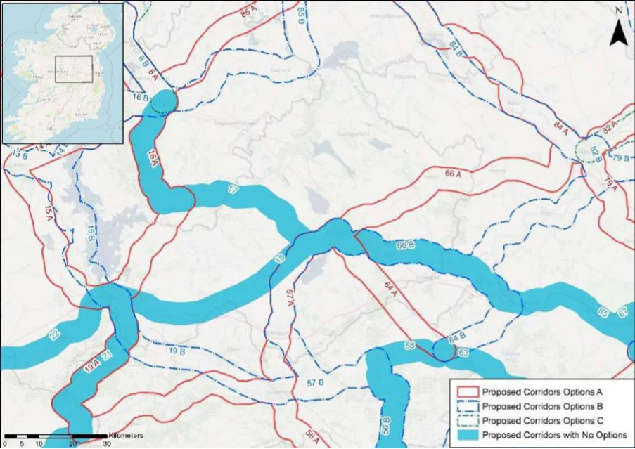
Table 57. Appraisal Relating to Corridor 57 Mullingar to Tullamore
Figure B15: Map of corridor option 57
| Option A | B |
|---|---|
| 1 | 2 |
| = | = |
SEA Theme Summary of the Potential Effects Associated with Corridor 57 Mullingar to Tullamore
Option A: Option A and B diverge between Tullamore and Kilbeggan. The corridor option Biodiversity traverses two SACs, one SPA, and seven pNHA/NHAs. including Lough Ennell SAC, SPA and pNHA, Split Hills and Long Hill Esker SAC and pNHA, Royal Canal pNHA, Grand Canal pNHA, Ballyduff Wood pNHA, and Derrygolan Esker pNHA. These designated sites and key sensitivities associated with the designations would need to be considered further when determining the final route during scheme development. Land take requirements are not known at this stage; however, it is anticipated the routes would utilise existing infrastructure such as roads where practicable. Option A is located further away from designated sites where it diverges from Option B. Option B: The corridor option traverses two SACs, one SPA, and eight pNHAs including the Lough Ennell SAC, SPA and pNHA, Split Hills and Long Hill Esker SAC and pNHA, Royal Canal pNHA, Grand Canal pNHA, Ardan Wood pNHA, and Murphy’s Bridge Esker pNHA. These designated sites and key sensitivities associated with the designations would need to be considered further when determining the final route during scheme development. Land take requirements are not known at this stage; however, it is anticipated the routes would utilise existing infrastructure such as roads where practicable. For example Option B could potentially use existing infrastructure such as the Grand Canal Greenway where it diverges from Option A and follows the Grand Canal pNHA.
Population and Human Health
The corridor options would link Tullamore (population c.24,270) with Mullingar (population c.20,930) via Kibeggan (population c.1,290). The options will support accessibility to the services, facilities and amenities and job opportunities available in these settlements. In this respect an enhancement of accessibility by active travel modes will promote social inclusion and the quality of life of residents and support health and wellbeing. The corridor options also have the potential to bring benefits for the visitor economy along the routes and support community vitality. Whilst Option A is a more direct route, Option B will utilise the Royal Canal, supporting the use of the canal as a tourism asset.
Appendix B: Corridor option assessment tables
National Cycle Network SEA Environmental Report (Updated)
Option
SEA Theme Summary of the Potential Effects Associated with Corridor 57 Mullingar to Tullamore A B
| Land and Option A: Land use along the proposed corridor / within the area is variable and includes Soils areas of urban fabric (artificial surfaces) and industrial or commercial units (artificial surfaces) in Tullamore and Mullingar and areas of pastures (agricultural areas), non-irrigated arable land (agricultural areas) peat bogs (wetland) as per CORINE 2018. Should the route primarily involve the reallocation of road space / recreational amenity infrastructure (Royal Canal) loss of land and loss of productive agricultural land is unlikely to be significant. Option B: Land use along the proposed corridor / within the area is variable and includes areas of urban fabric (artificial surfaces) and industrial or commercial units (artificial surfaces) in Tullamore and Mullingar and areas of pastures (agricultural areas), non-irrigated arable land (agricultural areas) peat bogs (wetland) as per CORINE 2018. Should the route primarily involve the reallocation of road space / recreational amenity infrastructure (Royal and Grand Canals), loss of land and loss of productive agricultural land is unlikely to be significant. Option B is likely to perform more favourably in relation to this SEA theme, as it aligns more along existing infrastructure (canal) and would rejuvenation and connect cultural heritage assets along this route. | 2 | 1 |
|---|---|---|
| Water Option A: Several watercourses occur along the route of the proposed corridor, including the Grand Canal, Silver River and the River Brosna. The WFD status of these watercourses ranges between ‘good’ and ‘poor’ during the 2013-2018 monitoring period. The watercourses within the proposed corridor ranges from ‘at risk’ to ‘under review’. Option B: Several watercourses occur along the route of the proposed corridor, including the Grand Canal, Tullamore River, Silver River and the River Brosna. The WFD status of these watercourses ranges between ‘good’ and ‘poor’ during the 2013-2018 monitoring period. The watercourses within the proposed corridor ranges from ‘at risk’ to ‘under review’. | = | = |
| Air Quality Options A & B: The route occurs in an area considered to be of ‘Good’ air quality. The route will provide a safe cycle route between Tullamore and Mullingar. This will promote a modal shift to active modes of travel which will in turn support ongoing improvements to air quality in the area. | = | = |
| Climate The development of the corridor options as part of the NCN would promote a shift to active Change modes of travel from higher emission modes, including the private car. This will support a limitation of greenhouse gas emissions from transport. The corridor options may cross (and potentially negatively/positively impact on) areas of flood risk. Whilst impacts on flood risk, and, more broadly, climate change adaptation, depends on the detailed route of the corridor and scheme design, there would be a need to ensure that the delivery of the corridor options supports the resilience of the local area to the potential effects of climate change. | = | = |
| Cultural Option A: A range of cultural heritage assets are present within the proposed corridor, such Heritage as a site (OF017-037----), church (Reg. No. 14909006), mill Reg. No. 15321036) and a bridge (Reg. No. 15401802). The development of the cycle corridor offers the potential for the rejuvenation and enhanced enjoyment of cultural heritage assets. However, the proposed corridor also has the potential to impact on the setting of archaeological assets which occur along the proposed corridor. Option B: A range of cultural heritage assets are present within the proposed corridor, such as a lock (Reg. No. 149170200), bridge (Reg. No. 14918006) and a bridge (Reg. No. 15403814). Given part of the proposed corridor is located along a canal / greenway, sensitive development of the corridor as a cycle route offers the potential for the rejuvenation and enhanced enjoyment of this heritage asset. However, the proposed corridor also has the potential to impact on the setting of other cultural heritage assets (e.g., archaeological remains) which may occur along the proposed corridor. Option B is likely to perform more favourably in relation to this SEA theme, as it aligns more along existing infrastructure (Royal Canal) and would rejuvenation and connect cultural heritage assets along this route. | 2 | 1 |
| Landscape The corridor options, given they largely follow existing transport corridors, are unlikely to lead to significant impacts on landscape character. They also offer opportunities to enhance the quality of the public realm, if high quality design and layouts are integrated within subsequent schemes. More broadly, the corridor options will support active travel modes, which are modes of transport with limited impacts on landscape character. Through promoting active travel modes, the corridor options will also support an enhanced understanding and enjoyment of the special qualities and intrinsic character of the landscape. | = | = |
Appendix B: Corridor option assessment tables AECOM
National Cycle Network
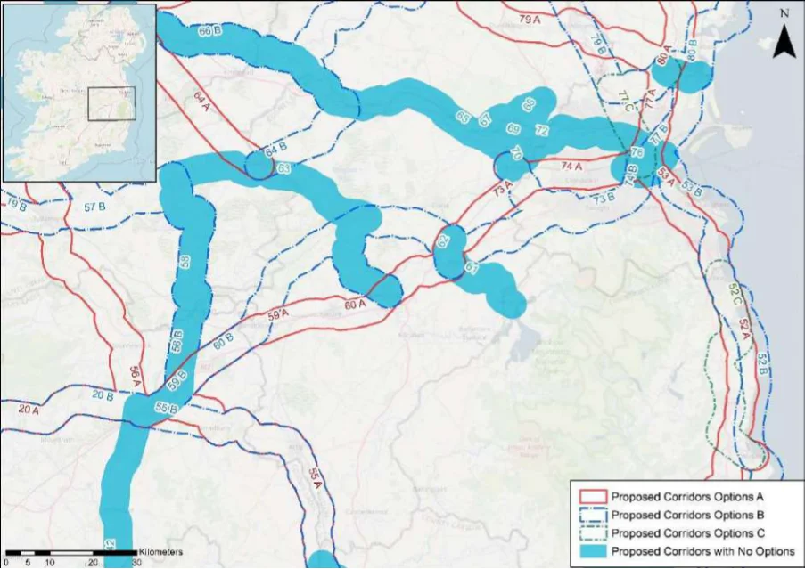
Table 58. Appraisal Relating to Corridor 58 Edenderry to Portlaoise
Figure B16: Map of corridor options 58, 59 and 60
Summary of the Potential Effects Associated with Corridor 58 Edenderry to SEA Theme Portlaoise
The corridor runs alongside the Grand Canal pNHA from approximately Edenderry to Biodiversity Toberdaly and crosses the River Barrow and River Nore SAC near Portarlington. Other designated sites within the corridor are Emo Court pNHA, the Great Heath of Portlaoise pNHA, Dunamase Woods pNHA, and the Ridge of Portlaoise pNHA. These designated sites and key sensitivities associated with the designations would need to be considered further when determining the final route during scheme development. Land take requirements are not known at this stage; however it is anticipated the route would utilise existing infrastructure such as roads and cycleways (for example the Grand Canal Greenway) where practicable.
Population and Human Health
The corridor would link Edenderry (population c.7,360) with Portlaoise (population c.22,050) via Portarlington (population c.8,370). In this respect the corridor would support an enhancement of accessibility to services and facilities from communities along the route by active travel modes, promoting social inclusion and the quality of life of residents and supporting health and wellbeing. The corridor also has the potential to bring benefits for the visitor economy along the corridor and support community vitality.
Land use along the proposed corridor / within the area is variable and includes areas of Land and Soils urban fabric (artificial surfaces) and industrial or commercial units (artificial surfaces) in Edenderry, Portarlington and Portlaoise and areas of pastures (agricultural areas), nonirrigated arable land (agricultural areas), coniferous forests (forest and semi-natural areas), mixed forest (forest and semi-natural areas) and peat bogs (wetland) as per CORINE 2018. Should the route primarily involve the reallocation of road space / recreational amenity infrastructure (Grand Canal), loss of land and loss of productive agricultural land is unlikely to be significant.
Several watercourses occur along the route of the proposed corridor, including the River Water Triogue, River Barrow, River Cushina, Esker Stream and the Grand Canal. The WFD status of these watercourses ranges between ‘good’ and ‘poor’ during the 2013-2018 monitoring period. The watercourses within the proposed corridor ranges from ‘at risk’ to ‘under review’.
The route occurs in an area considered to be of ‘Good’ air quality. The route will provide a Air Quality safe cycle route between Edenderry and Portlaoise. This will promote a modal shift to active modes of travel which will in turn support ongoing improvements to air quality in the area.
Appendix B: Corridor option assessment tables
National Cycle Network SEA Environmental Report (Updated)
Summary of the Potential Effects Associated with Corridor 58 Edenderry to SEA Theme Portlaoise
Impact
The development of the corridor as part of the NCN would promote a shift to active modes Climate Change of travel from higher emission modes, including the private car. This will support a limitation of greenhouse gas emissions from transport. The corridor may cross (and potentially negatively/positively impact on) areas of flood risk. Whilst impacts on flood risk, and, more broadly, climate change adaptation, depends on the detailed route of the corridor and scheme design, there would be a need to ensure that the delivery of the corridor supports the resilience of the local area to the potential effects of climate change.
Positive
Cultural Heritage A range of cultural heritage assets are present within the proposed corridor, such as a
bridge (Reg. No. 14911021), church (OF019-001003-) and an enclosure (LA013-024----). Given a small part of the proposed corridor is located along a canal / greenway, sensitive development of the corridor as a cycle route offers the potential for the rejuvenation and enhanced enjoyment of this heritage asset. However, the proposed corridor also has the potential to impact on the setting of other cultural heritage assets (e.g., archaeological remains) which may occur along the proposed corridor.
Uncertain
The proposed corridor, given it is likely to follow existing transport infrastructure, is unlikely Landscape to lead to significant impacts on landscape character. It also offers opportunities to enhance the quality of the public realm, if high quality design and layouts are integrated within subsequent schemes. More broadly, the implementation of the corridor will support active travel modes, which are modes of transport with limited impacts on landscape character. Through promoting active travel modes, the corridor also offers opportunities to support an enhanced understanding and enjoyment of the special qualities and intrinsic character of the landscape in the vicinity of the corridor.
Positive
Appendix B: Corridor option assessment tables AECOM
National Cycle Network
Table 59. Appraisal Relating to Corridor 59 Portlaoise to Naas
SEA Theme Summary of the Potential Effects Associated with Corridor 59 Newbridge to Naas
| Biodiversity Option A & B: Options A and B are located between Naas and Portlaoise. Whilst the corridor options diverge between Naas and Monasteravin both corridors options traverse similar designated sites. The designated sites traversed by both options are: the River Barrow and River Nore SAC, Derries Wood pNHA, Emo Court pNHA , the Great Heath of Portlaoise pNHA, Dunamase Woods pNHA, Ridge of Portlaoise pNHA, and Grand Canal pNHA. Option A also traverses Pollardstown Fen SAC and pNHA, and Curragh (Kildare) pNHA, while Option B traverses Ballynafagh Bog SAC and pNHA. These designated sites and key sensitivities associated with the designations would need to be considered further when determining the final route during scheme development. Land take requirements are not known at this stage; however, it is anticipated the routes would utilise existing infrastructure such as roads, towpaths and cycleways (for example the Grand Canal Greenway) where practicable. | = | = |
|---|---|---|
| Population The corridor options would link Portlaosie (population c.22,050) with Naas (population and Human c.21,400) via Monasterevan (population c.4,250). Health Option A will also link Kildare (population c.8,634) and Newbridge (population c. 22,742) and Option B will also link Rathangan (population c.2,610) and Sallins (population c. 5,849). The options will support accessibility to the services, facilities and amenities and job opportunities available in these settlements. In this respect an enhancement of accessibility by active travel modes will promote social inclusion and the quality of life of residents and support health and wellbeing. The corridor options also have the potential to bring benefits for the visitor economy along the routes and support community vitality. Given Option A links larger population centres, the option performs better than Option B in relation to this SEA theme. | 1 | 2 |
| Land and Option A: Land use along the proposed corridor / within the area is variable and includes Soils areas of urban fabric (artificial surfaces) in Newbridge and Naas and areas of pastures (agricultural areas) as per CORINE 2018. Should the route primarily involve the reallocation of road space / recreational amenity infrastructure, loss of land and loss of productive agricultural land is unlikely to be significant. Option B: Land use along the proposed corridor / within the area is variable and includes areas of urban fabric (artificial surfaces) in Portlaoise, Monsterevin, Rathangan and Naas and areas of pastures (agricultural areas) as per CORINE 2018. Should the route primarily involve the reallocation of road space, loss of land and loss of productive agricultural land is unlikely to be significant. Option B is likely to perform more favourably in relation to this SEA theme as it aligns more along existing infrastructure (Grand Canal) and would require less land-take (from agriculture). | 2 | 1 |
| Water Option A: There is a watercourse along the route of the proposed corridor, this is the River Liffey. The WFD status of this watercourse ranges between ‘good’ and ‘moderate’ during the 2013-2018 monitoring period. The watercourse within the proposed corridor is ‘at risk’. Option B: Several watercourses occur along the route of the proposed corridor, including the River Triogue, River Barrow, River Slate, River Liffey and the Grand Canal. The WFD status of these watercourses ranges between ‘good’ and ‘poor’ during the 2013-2018 monitoring period. The watercourses within the proposed corridor ranges from ‘at risk’ to ‘under review’. | = | = |
| Air Quality Option A & B: The route occurs in an area considered to be of ‘Good’ air quality. The route will provide a safe cycle route between Newbridge and Naas. This will promote a modal shift to active modes of travel which will in turn support ongoing improvements to air quality in the area. | = | = |
| Climate The development of the corridor options as part of the NCN would promote a shift to active Change modes of travel from higher emission modes, including the private car. This will support a limitation of greenhouse gas emissions from transport. Option A, given it links larger population centres, will however bring additional benefits in relation to this element of climate change mitigation. The corridor options may cross (and potentially negatively/positively impact on) areas of flood risk. Whilst impacts on flood risk, and, more broadly, climate change adaptation, depends on the detailed route of the corridor and scheme design, there would be a need to ensure that the delivery of the corridor options supports the resilience of the local area to the potential effects of climate change. | 1 | 2 |
Appendix B: Corridor option assessment tables
National Cycle Network SEA Environmental Report (Updated)
| Option A | B |
|---|---|
| 2 | 1 |
| = | = |
SEA Theme Summary of the Potential Effects Associated with Corridor 59 Newbridge to Naas
Option A: A range of cultural heritage assets are present within the proposed corridor, such as an enclosure (KD023-010----), bridge (Reg. No. 1190190) and a gatehouse (KD019-032- ---). The development of the cycle corridor offers the potential for the rejuvenation and enhanced enjoyment of cultural heritage assets. However, the proposed corridor also has the potential to impact on the setting of archaeological assets which occur along the proposed corridor. Option B: A range of cultural heritage assets are present within the proposed corridor, such as a ringfort (L A005-009----), house (Reg. No. 11902112) and a school (Reg. No. 11901809). Given a part of the proposed corridor is located along a canal / greenway, sensitive development of the corridor as a cycle route offers the potential for the rejuvenation and enhanced enjoyment of this heritage asset. However, the proposed corridor also has the potential to impact on the setting of other cultural heritage assets (e.g., archaeological remains) which may occur along the proposed corridor. Option B is likely to perform more favourably in relation to this SEA theme, as it aligns along existing infrastructure (greenway / Grand Canal) and would rejuvenation and connect cultural heritage assets along this route.
The corridor options, given they largely follow existing transport corridors, are unlikely to lead Landscape to significant impacts on landscape character. They also offer opportunities to enhance the quality of the public realm, if high quality design and layouts are integrated within subsequent schemes. More broadly, the corridor options will support active travel modes, which are modes of transport with limited impacts on landscape character. Through promoting active travel modes, the corridor options will also support an enhanced understanding and enjoyment of the special qualities and intrinsic character of the landscape.
Appendix B: Corridor option assessment tables AECOM
National Cycle Network
Table 60. Appraisal Relating to Corridor 60 Portlaoise to Newbridge
Summary of the Potential Effects Associated with Corridor 60 Portlaoise to SEA Theme Newbridge
| Biodiversity Options A & B: Options A and B are located between Newbridge and Portlaoise. Whilst the corridor options diverge between Newbridge, Ballyteige and Monasteravin, both corridors traverse similar designated sites. The designated sites traversed by both options are: the River Barrow and River Nore SAC, Derries Wood pNHA, Emo Court pNHA, the Great Heath of Portlaoise pNHA, Dunamase Woods pNHA, Ridge of Portlaoise pNHA, Grand Canal pNHA, Pollardstown Fen SAC and pNHA, and Mouds Bog SAC and pNHA. Option A also traverses Curragh (Kildare) pNHA. These designated sites and key sensitivities associated with the designations would need to be considered further when determining the final route during scheme development. Land take requirements are not known at this stage; however, it is anticipated the routes would utilise existing infrastructure such as roads where practicable. | = | = |
|---|---|---|
| Population and The corridor options would link Portlaosie (population c.22,050) with Newbridge Human Health (population c.22,742) via Monasterevan (population c.4,250). Option A will also link Kildare (population c.8,634), and Option B will also link Rathangan (population c.2,610). The options will support accessibility to the services, facilities and amenities and job opportunities available in these settlements. In this respect an enhancement of accessibility by active travel modes will promote social inclusion and the quality of life of residents and support health and wellbeing. The corridor options also have the potential to bring benefits for the visitor economy along the routes and support community vitality. Given Option A links a larger population centre, the option performs better than Option B in relation to this SEA theme. | 1 | 2 |
| Land and Soils Option A: Land use along the proposed corridor / within the area is variable and includes areas of urban fabric (artificial surfaces) in Portlaoise, Monasterevin, Kildare and Newbridge and areas of pastures (agricultural areas) as per CORINE 2018. Should the route primarily involve the reallocation of road space, loss of land and loss of productive agricultural land is unlikely to be significant Option B: Land use along the proposed corridor / within the area is variable and includes areas of urban fabric (artificial surfaces) in Portlaoise, Monasterevin, Rathagan and Newbridge and areas of pastures (agricultural areas) as per CORINE 2018. Should the route primarily involve the reallocation of road space / recreational amenity infrastructure, loss of land and loss of productive agricultural land is unlikely to be significant. Option B is likely to perform more favourably in relation to this SEA theme as it aligns more along existing infrastructure (Grand Canal) and would require less land-take (from agriculture). | 2 | 1 |
| Water Option A: Several watercourses occur along the route of the proposed corridor, including the River Triogue, River Barrow and the River Liffey. The WFD status of these watercourses ranges between ‘good’ and ‘poor’ during the 2013-2018 monitoring period. The watercourses within the proposed corridor ranges from ‘at risk’ to ‘under review’. Option B: Several watercourses occur along the route of the proposed corridor, including the River Triogue, River Barrow, Grand Canal, Cloncumber Stream and the River Liffey. The WFD status of these watercourses ranges between ‘good’ and ‘poor’ during the 2013- 2018 monitoring period. The watercourses within the proposed corridor ranges from ‘at risk’ to ‘under review’. | = | = |
| Air Quality Options A & B: The route occurs in an area considered to be of ‘Good’ air quality. The route will provide a safe cycle route between Portlaoise and Newbridge. This will promote a modal shift to active modes of travel which will in turn support ongoing improvements to air quality in the area. | = | = |
| Climate Change The development of the corridor options as part of the NCN would promote a shift to active modes of travel from higher emission modes, including the private car. This will support a limitation of greenhouse gas emissions from transport. Option A, given it links larger population centres, will however bring additional benefits in relation to this element of climate change mitigation. The corridor options may cross (and potentially negatively/positively impact on) areas of flood risk. Whilst impacts on flood risk, and, more broadly, climate change adaptation, depends on the detailed route of the corridor and scheme design, there would be a need to ensure that the delivery of the corridor options supports the resilience of the local area to the potential effects of climate change. | 1 | 2 |
Appendix B: Corridor option assessment tables
National Cycle Network SEA Environmental Report (Updated)
| Option A | B |
|---|---|
| 2 | 1 |
| = | = |
Summary of the Potential Effects Associated with Corridor 60 Portlaoise to SEA Theme Newbridge
Option A: A range of cultural heritage assets are present within the proposed corridor, Cultural Heritage such as a fulacht fia (KD022-111----) and a mound (KD023-059----). The development of the cycle corridor offers the potential for the rejuvenation and enhanced enjoyment of cultural heritage assets. However, the proposed corridor also has the potential to impact on the setting of archaeological assets which occur along the proposed corridor. Option B: A range of cultural heritage assets are present within the proposed corridor, such as a bridge (Reg. No. 11901602) and a standing stone (KD017-049----). Given a part of the proposed corridor is located along a canal (Grand Canal), sensitive development of the corridor as a cycle route offers the potential for the rejuvenation and enhanced enjoyment of this heritage asset. However, the proposed corridor also has the potential to impact on the setting of other cultural heritage assets (e.g., archaeological remains) which may occur along the proposed corridor. Option B is likely to perform more favourably in relation to this SEA theme, as it aligns along existing infrastructure (greenway / Grand Canal) and would rejuvenation and connect cultural heritage assets along this route.
The corridor options, given they largely follow existing transport corridors, are unlikely to Landscape lead to significant impacts on landscape character. They also offer opportunities to enhance the quality of the public realm, if high quality design and layouts are integrated within subsequent schemes. More broadly, the corridor options will support active travel modes, which are modes of transport with limited impacts on landscape character. Through promoting active travel modes, the corridor options will also support an enhanced understanding and enjoyment of the special qualities and intrinsic character of the landscape.
Appendix B: Corridor option assessment tables AECOM
National Cycle Network
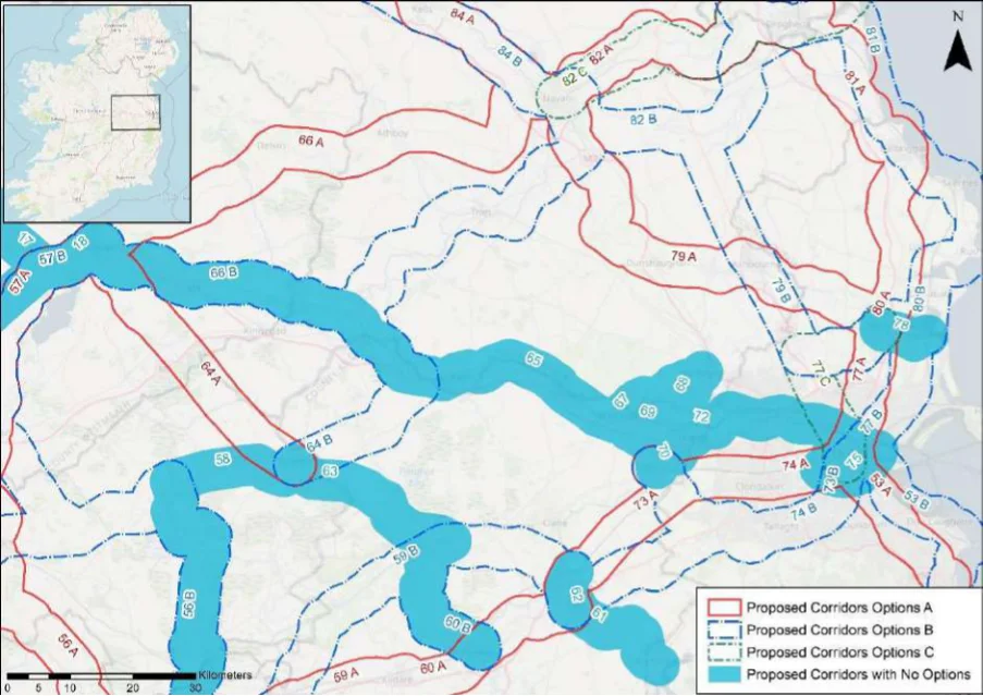
Table 61. Appraisal Relating to Corridor 61 Nass to Blessington
Figure B17: Map of corridor options 61, 62, 63 and 64
SEA Theme Summary of the Potential Effects Associated with Corridor 61 Nass to Blessington
The Grand Canal pNHA, Red Bog, Kildare SAC and pNHA, and the Poulaphouca Reservoir Biodiversity SPA and pNHA are located within the corridor. These designated sites and key sensitivities associated with the designations would need to be considered further when determining the final route during scheme development. Land take requirements are not known at this stage; however, it is anticipated the route would utilise existing infrastructure such as roads where practicable.
Population and Human Health
The corridor would link Naas (population c.21,400) with Blessington (population c.5,520). The corridor would support an enhancement of accessibility to services and facilities to the two communities by active travel modes, promoting social inclusion and the quality of life of residents and supporting health and wellbeing. The corridor also has the potential to bring benefits for the visitor economy along the corridor and support community vitality.
Land use along the proposed corridor / within the area is variable and includes areas of Land and Soils urban fabric (artificial surfaces) in Naas and Blessington and areas of pastures (agricultural areas), non-irrigated arable land (agricultural areas) and coniferous forests (forest and semi-natural areas) as per CORINE 2018. Should the route primarily involve the reallocation of road space, loss of land and loss of productive agricultural land is unlikely to be significant.
Several watercourses occur along the route of the proposed corridor, including the River Water Liffey and the River Morell. The WFD status of these watercourses ranges between ‘good’ and ‘moderate’ during the 2013-2018 monitoring period. The watercourses within the proposed corridor ranges from ‘at risk’ to ‘under review’.
The route occurs in an area considered to be of ‘Good’ air quality. The route will provide a Air Quality safe cycle route between Naas and Blessington. This will promote a modal shift to active modes of travel which will in turn support ongoing improvements to air quality in the area.
The development of the corridor as part of the NCN would promote a shift to active modes Climate Change of travel from higher emission modes, including the private car. This will support a limitation of greenhouse gas emissions from transport. The corridor may cross (and potentially negatively/positively impact on) areas of flood risk. Whilst impacts on flood risk, and, more broadly, climate change adaptation, depends on the detailed route of the corridor and scheme design, there would be a need to ensure that the
Appendix B: Corridor option assessment tables
National Cycle Network SEA Environmental Report (Updated)
SEA Theme Summary of the Potential Effects Associated with Corridor 61 Nass to Blessington Impact
delivery of the corridor supports the resilience of the local area to the potential effects of climate change.
Cultural Heritage A range of cultural heritage assets are present within the proposed corridor, such as a ritual
site (KD019-031----) and a ringfort (WI005-012----). The development of the cycle corridor offers the potential for the rejuvenation and enhanced enjoyment of cultural heritage assets. However, the proposed corridor also has the potential to impact on the setting of archaeological assets which occur along the proposed corridor.
Uncertain
The proposed corridor, given it is likely to follow existing transport infrastructure, is unlikely Landscape to lead to significant impacts on landscape character. It also offers opportunities to enhance the quality of the public realm, if high quality design and layouts are integrated within subsequent schemes. More broadly, the implementation of the corridor will support active travel modes, which are modes of transport with limited impacts on landscape character. Through promoting active travel modes, the corridor also offers opportunities to support an enhanced understanding and enjoyment of the special qualities and intrinsic character of the landscape in the vicinity of the corridor.
Positive
Appendix B: Corridor option assessment tables AECOM
National Cycle Network
Table 62. Appraisal Relating to Corridor 62 Naas to Sallins
SEA Theme Summary of the Potential Effects Associated with Corridor 62 Naas to Sallins
| Biodiversity The route runs between Naas and Sallins and follows the Grand Canal pNHA. Key sensitivities associated with this designation would need to be considered further when determining the final route during scheme development. Land take requirements are not known at this stage; however it is anticipated the route would utilise existing infrastructure such as roads where practicable. | Uncertain |
|---|---|
| Population and The corridor would link Naas (population c.21,400) with Sallins (population c.5,850). The Human Health corridor would support an enhancement of accessibility to services and facilities in Naas from Sallins by active travel modes, promoting social inclusion and the quality of life of residents and supporting health and wellbeing. The corridor also has the potential to bring benefits for the visitor economy along the corridor and support community vitality. | Positive |
| Land and Soils Land use along the proposed corridor / within the area is variable and includes areas of urban fabric (artificial surfaces) in Naas and Sallins and areas of pastures (agricultural areas) as per CORINE 2018. Should the route primarily involve the reallocation of road space / recreational walking amenity infrastructure (Grand Canal), loss of land and loss of productive agricultural land is unlikely to be significant. | Uncertain |
| Water A watercourse occurs along the route of the proposed corridor, the River Liffey. The WFD status of this watercourse is ‘good’ during the 2013-2018 monitoring period. | Uncertain |
| Air Quality The route occurs in an area considered to be of ‘Good’ air quality. The route will provide a safe cycle route between Naas and Sallins. This will promote a modal shift to active modes of travel which will in turn support ongoing improvements to air quality in the area. | Positive |
| Climate Change The development of the corridor as part of the NCN would promote a shift to active modes of travel from higher emission modes, including the private car. This will support a limitation of greenhouse gas emissions from transport. The corridor may cross (and potentially negatively/positively impact on) areas of flood risk. Whilst impacts on flood risk, and, more broadly, climate change adaptation, depends on the detailed route of the corridor and scheme design, there would be a need to ensure that the delivery of the corridor supports the resilience of the local area to the potential effects of climate change. | Positive |
| Cultural Heritage A range of cultural heritage assets are present within the proposed corridor, such as a lock (Reg. No. 11814133) and a house (Reg. No. 11811026). Given a part of the proposed corridor is located along a canal (Grand Canal), sensitive development of the corridor as a cycle route offers the potential for the rejuvenation and enhanced enjoyment of this heritage asset. However, the proposed corridor also has the potential to impact on the setting of other cultural heritage assets (e.g., archaeological remains) which may occur along the proposed corridor. | Uncertain |
| Landscape The proposed corridor, given it is likely to follow existing transport infrastructure, is unlikely to lead to significant impacts on landscape character. It also offers opportunities to enhance the quality of the public realm, if high quality design and layouts are integrated within subsequent schemes. More broadly, the implementation of the corridor will support active travel modes, which are modes of transport with limited impacts on landscape character. Through promoting active travel modes, the corridor also offers opportunities to support an enhanced understanding and enjoyment of the special qualities and intrinsic character of the landscape in the vicinity of the corridor. | Positive |
Appendix B: Corridor option assessment tables
National Cycle Network
Table 63. Appraisal Relating to Corridor 63 Edenderry to Newbridge
SEA Theme Summary of the Potential Effects Associated with Corridor 63 Edenderry to Naas
| Biodiversity The corridor traverses the Grand Canal pNHA, The Long Derries, Edenderry SAC and pNHA, Pollardstown Fen SAC and pNHA, and Mouds Bog SAC and pNHA. These designated sites and key sensitivities associated with the designations would need to be considered further when determining the final route during scheme development. Land take requirements are not known at this stage; however, it is anticipated the route would utilise existing infrastructure such as roads and cycleways (for example the Grand Canal Greenway) where practicable. | Uncertain |
|---|---|
| Population and The corridor would link Naas (population c.21,400) with Edenderry (population c.3,760). Human Health The corridor would support an enhancement of accessibility to services and facilities to the two communities by active travel modes, promoting social inclusion and the quality of life of residents and supporting health and wellbeing. The corridor also has the potential to bring benefits for the visitor economy along the corridor and support community vitality. | Positive |
| Land and Soils Land use along the proposed corridor / within the area is variable and includes areas of urban fabric (artificial surfaces) and industrial or commercial units (artificial surfaces) in Edenderry, Sallins and Naas and areas of pastures (agricultural areas), peat bogs (wetland), non-irrigated arable land (agricultural areas) as per CORINE 2018. Should the route primarily involve the reallocation of road space / recreational walking amenity infrastructure (Grand Canal), loss of land and loss of productive agricultural land is unlikely to be significant. | Uncertain |
| Water Several watercourses occur along the route of the proposed corridor, including the River Boyne, River Figile, Grand Canal, River Slate and the River Liffey. The WFD status of these watercourses ranges between ‘moderate’ and ‘poor’ during the 2013-2018 monitoring period. The watercourses within the proposed corridor ranges from ‘at risk’ to ‘under review’. | Uncertain |
| Air Quality The route occurs in an area considered to be of ‘Good’ air quality. The route will provide a safe cycle route between Edenderry and Naas. This will promote a modal shift to active modes of travel which will in turn support ongoing improvements to air quality in the area. | Positive |
| Climate Change The development of the corridor as part of the NCN would promote a shift to active modes of travel from higher emission modes, including the private car. This will support a limitation of greenhouse gas emissions from transport. The corridor may cross (and potentially negatively/positively impact on) areas of flood risk. Whilst impacts on flood risk, and, more broadly, climate change adaptation, depends on the detailed route of the corridor and scheme design, there would be a need to ensure that the delivery of the corridor supports the resilience of the local area to the potential effects of climate change. | Positive |
| Cultural Heritage A range of cultural heritage assets are present within the proposed corridor, such as a milestone post (Reg. No. 14912010) and a ring ditch (KD019-081----). Given a part of the proposed corridor is located along a canal (Grand Canal), sensitive development of the corridor as a cycle route offers the potential for the rejuvenation and enhanced enjoyment of this heritage asset. However, the proposed corridor also has the potential to impact on the setting of other cultural heritage assets (e.g., archaeological remains) which may occur along the proposed corridor. | Uncertain |
| Landscape The proposed corridor, given it is likely to follow existing transport infrastructure, is unlikely to lead to significant impacts on landscape character. It also offers opportunities to enhance the quality of the public realm, if high quality design and layouts are integrated within subsequent schemes. More broadly, the implementation of the corridor will support active travel modes, which are modes of transport with limited impacts on landscape character. Through promoting active travel modes, the corridor also offers opportunities to support an enhanced understanding and enjoyment of the special qualities and intrinsic character of the landscape in the vicinity of the corridor. | Positive |
Appendix B: Corridor option assessment tables
National Cycle Network
Table 64. Appraisal Relating to Corridor 64 Mullingar to Edenderry
SEA Theme Summary of the Potential Effects Associated with Corridor 64 Mullingar to Edenderry
| Biodiversity Option A: Designated sites located within the corridor include the Royal Canal Greenway pNHA, Black Castle Bog NHA, and Milltownpass Bog NHA. These designated sites and key sensitivities associated with the designations would need to be considered further when determining the final route during scheme development. Land take requirements are not known at this stage however the route corridor occurs within predominately greenfield areas and would traverse several fields. Option B: A section of the corridor between Mullingar and Kilmore is adjacent to the Royal Canal Greenway pNHA. Other designated sites within the corridor include Wooddown Bog SAC and NHA, Mount Hevey Bog SAC and pNHA, Molerick Bog NHA, Ballina Bog pNHA, Carbury Bog NHA, and River Boyne and River Blackwater SAC. These designated sites and key sensitivities associated with the designations would need to be considered further when determining the final route during scheme development. Land take requirements are not known at this stage; however, it is anticipated the route would utilise existing infrastructure such as roads and cycleways (for example the Royal Canal Greenway) where practicable. | = | = |
|---|---|---|
| Population The corridor options would link Mullingar (population c.21,400) with Edenderry (population and Human c.7,360). Health The options will support accessibility to the services, facilities and amenities and job opportunities available in these settlements. In this respect an enhancement of accessibility by active travel modes will promote social inclusion and the quality of life of residents and support health and wellbeing. The corridor options also have the potential to bring benefits for the visitor economy along the routes and support community vitality. | = | = |
| Land and Soils Option A: Land use along the proposed corridor / within the area is variable and includes areas of urban fabric (artificial surfaces) and industrial or commercial units (artificial surfaces) in Mullingar and Edenderry and areas of pastures (agricultural areas), peat bogs (wetland), non-irrigated arable land (agricultural areas) and forest and semi-natural areas (forest and semi-natural areas) as per CORINE 2018. Should the route primarily involve the reallocation of road space, loss of land and loss of productive agricultural land is unlikely to be significant. Option B: Land use along the proposed corridor / within the area is variable and includes areas of urban fabric (artificial surfaces) and industrial or commercial units (artificial surfaces) in Mullingar and Edenderry and areas of pastures (agricultural areas), peat bogs (wetland), non-irrigated arable land (agricultural areas) and forest and semi-natural areas (forest and semi-natural areas) as per CORINE 2018. Should the route primarily involve the reallocation of road space / recreational walking amenity infrastructure / rail line, loss of land and loss of productive agricultural land is unlikely to be significant. | = | = |
| Water Option A: Several watercourses occur along the route of the proposed corridor, including the Milltown River, Monagh River and the Yellow River. The WFD status of these watercourses ranges between ‘good’ and ‘poor’ during the 2013-2018 monitoring period. The watercourses within the proposed corridor ranges from ‘at risk’ to ‘under review’. Option B: Several watercourses occur along the route of the proposed corridor, including the River Brosna, Royal Canal, River Deel, River Boyne. The WFD status of these watercourses ranges between ‘good’ and ‘poor’ during the 2013-2018 monitoring period. The watercourses within the proposed corridor ranges from ‘at risk’ to ‘under review’. | = | = |
| Air Quality Options A and B: The route occurs in an area considered to be of ‘Good’ air quality. The route will provide a safe cycle route between Mullingar and Edenderry. This will promote a modal shift to active modes of travel which will in turn support ongoing improvements to air quality in the area. | = | = |
| Climate The development of the corridor options as part of the NCN would promote a shift to active Change modes of travel from higher emission modes, including the private car. This will support a limitation of greenhouse gas emissions from transport. The corridor options may cross (and potentially negatively/positively impact on) areas of flood risk. Whilst impacts on flood risk, and, more broadly, climate change adaptation, depends on the detailed route of the corridor and scheme design, there would be a need to ensure that the delivery of the corridor options supports the resilience of the local area to the potential effects of climate change. | = | = |
Appendix B: Corridor option assessment tables
National Cycle Network SEA Environmental Report (Updated)
| Option A | B |
|---|---|
| 2 | 1 |
| = | = |
SEA Theme Summary of the Potential Effects Associated with Corridor 64 Mullingar to Edenderry
Cultural Heritage
Option A: A range of cultural heritage assets are present within the proposed corridor, such as ringforts (WM026-021----) and (WM026-034----). The development of the cycle corridor offers the potential for the rejuvenation and enhanced enjoyment of cultural heritage assets. However, the proposed corridor also has the potential to impact on the setting of archaeological assets which occur along the proposed corridor. Option B: A range of cultural heritage assets are present within the proposed corridor, such as a bridge (Reg. No. 15402712), house (Reg. No. 11900302) and enclosure (KD003-047- ---). Given a part of the proposed corridor is located along a canal (Royal Canal) and a rail line, sensitive development of the corridor as a cycle route offers the potential for the rejuvenation and enhanced enjoyment of this heritage asset. However, the proposed corridor also has the potential to impact on the setting of other cultural heritage assets (e.g., archaeological remains) which may occur along the proposed corridor. Option B is likely to perform more favourably in relation to this SEA theme, as it aligns along existing infrastructure (Royal Canal) and would rejuvenation and connect cultural heritage assets along this cultural heritage asset.
The corridor options, given they largely follow existing transport corridors, are unlikely to Landscape lead to significant impacts on landscape character. They also offer opportunities to enhance the quality of the public realm, if high quality design and layouts are integrated within subsequent schemes. More broadly, the corridor options will support active travel modes, which are modes of transport with limited impacts on landscape character. Through promoting active travel modes, the corridor options will also support an enhanced understanding and enjoyment of the special qualities and intrinsic character of the landscape.
Appendix B: Corridor option assessment tables AECOM
National Cycle Network
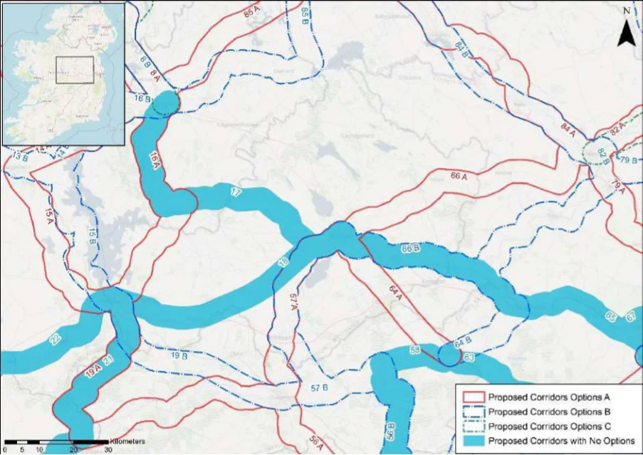
Table 65. Appraisal Relating to Corridor 65 Mullingar to Maynooth
Figure B18: Map of corridor options 65 and 66
SEA Theme Summary of the Potential Effects Associated with Corridor 65 Mullingar to Maynooth Impact
The corridor traverses the Royal Canal Greenway pNHA, Wooddown Bog SAC and NHA, Biodiversity Mount Hevey Bog SAC and pNHA, Molerick Bog NHA, Ballina Bog pNHA, River Boyne and River Blackwater SAC. These designated sites and key sensitivities associated with the designations would need to be considered further when determining the final route during scheme development. Land take requirements are not known at this stage; however it is anticipated the route would utilise existing infrastructure such as roads and cycleways (for example the Royal Canal Greenway) where practicable. The corridor follows the Royal Canal for the majority of the route.
Population and Human Health
The corridor would link Mullingar (population c.21,400) with Maynooth (population c. 14,585) via Longwood (population c.1,580), Enfield (population c.3,239) and Kilcock (population c. 6,093). The corridor would support an enhancement of accessibility to services and facilities in the settlements by active travel modes, promoting social inclusion and the quality of life of residents and supporting health and wellbeing. The corridor also has the potential to bring benefits for the visitor economy along the corridor and support community vitality.
Land use along the proposed corridor / within the area is variable and includes areas of Land and Soils urban fabric (artificial surfaces) in Mullingar, Enfield, Kilcock and Maynooth and areas of pastures (agricultural areas), peat bogs (wetland), non-irrigated arable land (agricultural areas) and forest and semi-natural areas (forest and semi-natural areas) as per CORINE 2018. Should the route primarily involve the reallocation of road space / recreational walking amenity infrastructure (Royal Canal), loss of land and loss of productive agricultural land is unlikely to be significant.
Several watercourses occur along the route of the proposed corridor, including the River Water Brosna, River Boyne, River Blackwater and the Royal Canal. The WFD status of these watercourses ranges between ‘good’ and ‘poor’ during the 2013-2018 monitoring period. The watercourses within the proposed corridor ranges from ‘at risk’ to ‘under review’.
The route occurs in an area considered to be of ‘Good’ air quality. The route will provide a Air Quality safe cycle route between Mullingar and Maynooth. This will promote a modal shift to active modes of travel which will in turn support ongoing improvements to air quality in the area.
Appendix B: Corridor option assessment tables
National Cycle Network SEA Environmental Report (Updated)
SEA Theme Summary of the Potential Effects Associated with Corridor 65 Mullingar to Maynooth Impact
The development of the corridor as part of the NCN would promote a shift to active modes Climate Change of travel from higher emission modes, including the private car. This will support a limitation of greenhouse gas emissions from transport. The corridor may cross (and potentially negatively / positively impact on) areas of flood risk. Whilst impacts on flood risk, and, more broadly, climate change adaptation, depends on the detailed route of the corridor and scheme design, there would be a need to ensure that the delivery of the corridor supports the resilience of the local area to the potential effects of climate change.
Positive
Cultural Heritage A range of cultural heritage assets are present within the proposed corridor, such as a castle
(WM019-076----), bridge (Reg. No. 11900303) and a ring ditch (KD005-003----) and a barrow (KD005-033----). Given a part of the proposed corridor is located along a canal (Royal Canal), sensitive development of the corridor as a cycle route offers the potential for the rejuvenation and enhanced enjoyment of this heritage asset. However, the proposed corridor also has the potential to impact on the setting of other cultural heritage assets (e.g., archaeological remains) which may occur along the proposed corridor.
Uncertain
The proposed corridor, given it is likely to follow existing transport infrastructure, is unlikely Landscape to lead to significant impacts on landscape character. It also offers opportunities to enhance the quality of the public realm if high quality design and layouts are integrated within subsequent schemes. More broadly, the implementation of the corridor will support active travel modes, which are modes of transport with limited impacts on landscape character. Through promoting active travel modes, the corridor also offers opportunities to support an enhanced understanding and enjoyment of the special qualities and intrinsic character of the landscape in the vicinity of the corridor.
Positive
Appendix B: Corridor option assessment tables AECOM
National Cycle Network
Table 66. Appraisal Relating to Corridor 66 Navan to Mullingar
SEA Theme Summary of the Potential Effects Associated with Corridor 66 Navan to Mullingar
| Biodiversity Option A: The corridor traverses the Lough Sheever Fen/Slevin’s Lough Complex pNHA, Wooddown Bog SAC and pNHA, Royal Canal pNHA, and River Boyne and River Blackwater SAC and SPA. These designated sites and key sensitivities associated with the designations would need to be considered further when determining the final route during scheme development. Land take requirements are not known at this stage; however, it is anticipated the route would utilise existing infrastructure such as roads where practicable; the route may also traverse sections of greenfield. Option B: The corridor traverses the Royal Canal pNHA, Wooddown Bog SAC and NHA, Mount Hevey Bog SAC and pNHA, Molerick Bog NHA, River Boyne and River Blackwater SAC and SPA, Trim pNHA. These designated sites and key sensitivities associated with the designations would need to be considered further when determining the final route during scheme development. Land take requirements are not known at this stage; however, it is anticipated the route would utilise existing infrastructure such as roads and cycleways (for example the Royal Canal Greenway) where practicable; the route may also traverse sections of greenfield. | = | = |
|---|---|---|
| Population The corridor options would link Navan (population c.30,170) with Mullingar (population and Human c.21,400). Option A would also link Athboy (population c.2,450), and Option B would also Health link Trim (population c.9,190). The options will support accessibility to the services, facilities and amenities and job opportunities available in these settlements. In this respect an enhancement of accessibility by active travel modes will promote social inclusion and the quality of life of residents and support health and wellbeing. The corridor options also have the potential to bring benefits for the visitor economy along the routes and support community vitality. | = | = |
| Land and Soils Option A: Land use along the proposed corridor / within the area is variable and includes areas of urban fabric (artificial surfaces) in Navan, Athboy and Mullingar and areas of pastures (agricultural areas), peat bogs (wetland), non-irrigated arable (agricultural areas) and forest and semi-natural areas (forest and semi-natural areas) as per CORINE 2018. Should the route primarily involve the reallocation of road space, loss of land and loss of productive agricultural land is unlikely to be significant. Option B: Land use along the proposed corridor / within the area is variable and includes areas of urban fabric (artificial surfaces) in Mullingar, Trim and Navan and areas of pastures (agricultural areas), peat bogs (wetland), non-irrigated arable (agricultural areas) and forest and semi-natural areas (forest and semi-natural areas) as per CORINE 2018. Should the route primarily involve the reallocation of road space / recreational walking amenity infrastructure (Royal Canal and the River Boyne), loss of land and loss of productive agricultural land is unlikely to be significant. | = | = |
| Water Option A: Several watercourses occur along the route of the proposed corridor, including the River Brosna, River Deel and the River Athboy. The WFD status of these watercourses ranges between ‘good’ and ‘poor’ during the 2013-2018 monitoring period. The watercourses within the proposed corridor ranges from ‘at risk’ to ‘under review’. Option B: Several watercourses occur along the route of the proposed corridor, including the River Brosna, River Deel, River Boyne and the River Clady. The WFD status of these watercourses ranges between ‘good’ and ‘poor’ during the 2013-2018 monitoring period. The watercourses within the proposed corridor ranges from ‘at risk’ to ‘under review’. | = | = |
| Air Quality Options A & B: The route occurs in an area considered to be of ‘Good’ air quality. The route will provide a safe cycle route between Mullingar and Navan. This will promote a modal shift to active modes of travel which will in turn support ongoing improvements to air quality in the area. | = | = |
| Climate The development of the corridor options as part of the NCN would promote a shift to active Change modes of travel from higher emission modes, including the private car. This will support a limitation of greenhouse gas emissions from transport. The corridor options may cross (and potentially negatively / positively impact on) areas of flood risk. Whilst impacts on flood risk, and, more broadly, climate change adaptation, depends on the detailed route of the corridor and scheme design, there would be a need to ensure that the delivery of the corridor options supports the resilience of the local area to the potential effects of climate change. | = | = |
Appendix B: Corridor option assessment tables
National Cycle Network SEA Environmental Report (Updated)
| Option A | B |
|---|---|
| 2 | 1 |
| = | = |
SEA Theme Summary of the Potential Effects Associated with Corridor 66 Navan to Mullingar
Cultural Heritage
Option A: A range of cultural heritage assets are present within the proposed corridor, such as a stone head (WM013-060002-) and a barrow WM014-007----). The development of the cycle corridor offers the potential for the rejuvenation and enhanced enjoyment of cultural heritage assets. However, the proposed corridor also has the potential to impact on the setting of archaeological assets which occur along the proposed corridor. Option B: A range of cultural heritage assets are present within the proposed corridor, such as a bridge (Reg. No. 15402651), bridge (Reg. No. 14404704) and a castle (ME041- 008---). Given a part of the proposed corridor is located along a canal (Royal Canal) and the River Boyne, sensitive development of the corridor as a cycle route offers the potential for the rejuvenation and enhanced enjoyment of this heritage asset. However, the proposed corridor also has the potential to impact on the setting of other cultural heritage assets (e.g., archaeological remains) which may occur along the proposed corridor. Option B is likely to perform more favourably in relation to this SEA theme, as it aligns along existing infrastructure (Royal Canal) and would rejuvenation and connect cultural heritage assets along this cultural heritage asset.
The corridor options, given they largely follow existing transport corridors, are unlikely to Landscape lead to significant impacts on landscape character. They also offer opportunities to enhance the quality of the public realm, if high quality design and layouts are integrated within subsequent schemes. More broadly, the corridor options will support active travel modes, which are modes of transport with limited impacts on landscape character. Through promoting active travel modes, the corridor options will also support an enhanced understanding and enjoyment of the special qualities and intrinsic character of the landscape.
Appendix B: Corridor option assessment tables AECOM
National Cycle Network
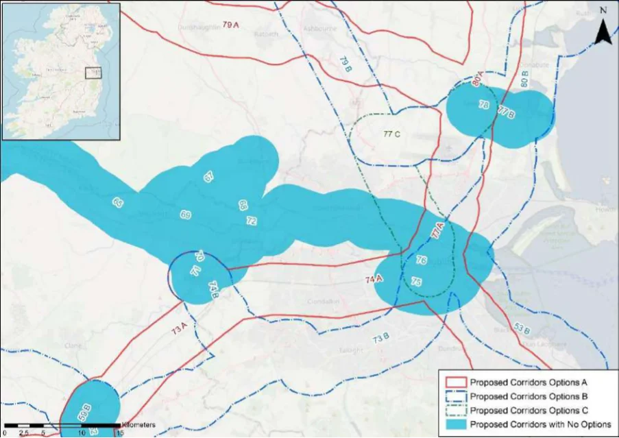
Table 67. Appraisal Relating to Corridor 67 Dunboyne to Maynooth
Figure B19: Map of corridor options 67, 68 and 69
SEA Theme Summary of the Potential Effects Associated with Corridor 67 Dunboyne to Maynooth
This corridor links Dunboyne and Maynooth and passes, the Rye Water Valley/Carton SAC Biodiversity and pNHA is located within the corridor. These designated sites and key sensitivities associated with the designations would need to be considered further when determining the final route during scheme development. Land take requirements are not known at this stage; however, it is anticipated the route would utilise existing infrastructure such as roads where practicable.
Population and Human Health
The corridor would link Maynooth (population c.14,585) with Dunboyne (population c.7,270). The corridor would support an enhancement of accessibility to services and facilities in the settlements by active travel modes, promoting social inclusion and the quality of life of residents and supporting health and wellbeing. The corridor also has the potential to bring benefits for the visitor economy along the corridor and support community vitality.
Land use along the proposed corridor / within the area is variable and includes areas of Land and Soils urban fabric (artificial surfaces) in Maynooth, Leixlip and Dunboyne and areas of pastures (agricultural areas) and non-irrigated arable (agricultural areas) as per CORINE 2018. Should the route primarily involve the reallocation of road space / recreational walking amenity infrastructure (Royal Canal), loss of land and loss of productive agricultural land is unlikely to be significant. Should the route require some land-take (from agriculture), the impact to likely to be significant / uncertain.
Several watercourses occur along the route of the proposed corridor, including the River Water Lyreen and the Dunboyne Stream. The WFD status of these watercourses ranges between ‘good’ and ‘poor’ during the 2013-2018 monitoring period. The watercourses within the proposed corridor ranges from ‘at risk’ to ‘under review’.
The route occurs in an area considered to be of ‘Good’ air quality. The route will provide a Air Quality safe cycle route between Maynooth and Dunboyne. This will promote a modal shift to active modes of travel which will in turn support ongoing improvements to air quality in the area.
The development of the corridor as part of the NCN would promote a shift to active modes Climate Change of travel from higher emission modes, including the private car. This will support a limitation of greenhouse gas emissions from transport.
Appendix B: Corridor option assessment tables
National Cycle Network SEA Environmental Report (Updated)
SEA Theme Summary of the Potential Effects Associated with Corridor 67 Dunboyne to Maynooth Impact
The corridor may cross (and potentially negatively/positively impact on) areas of flood risk. Whilst impacts on flood risk, and, more broadly, climate change adaptation, depends on the detailed route of the corridor and scheme design, there would be a need to ensure that the delivery of the corridor supports the resilience of the local area to the potential effects of climate change.
Cultural Heritage A range of cultural heritage assets are present within the proposed corridor, such as a
church (KD006-007001-) and an enclosure (ME050-048005-). The development of the cycle corridor offers the potential for the rejuvenation and enhanced enjoyment of cultural heritage assets. However, the proposed corridor also has the potential to impact on the setting of archaeological assets which occur along the proposed corridor.
Uncertain
The proposed corridor, given it is likely to follow existing transport infrastructure, is unlikely Landscape to lead to significant impacts on landscape character. It also offers opportunities to enhance the quality of the public realm, if high quality design and layouts are integrated within subsequent schemes. More broadly, the implementation of the corridor will support active travel modes, which are modes of transport with limited impacts on landscape character. Through promoting active travel modes, the corridor also offers opportunities to support an enhanced understanding and enjoyment of the special qualities and intrinsic character of the landscape in the vicinity of the corridor.
Positive
Appendix B: Corridor option assessment tables AECOM
National Cycle Network
Table 68. Appraisal Relating to Corridor 68 Dunboyne to Leixlip
SEA Theme Summary of the Potential Effects Associated with Corridor 68 Dunboyne to Leixlip
| Biodiversity This corridor links Dunboyne and Leixlip and traverses the Royal Canal pNHA, Liffey Valley pNHA, and Rye Water Valley / Carton SAC and pNHA. These designated sites and key sensitivities associated with the designations would need to be considered further when determining the final route during scheme development. Land take requirements are not known at this stage; however, it is anticipated the route would utilise existing infrastructure such as roads where practicable. | Uncertain |
|---|---|
| Population and The corridor would link Dunboyne (population c.7,270) with Leixlip (population c.15,500). Human Health The corridor would support an enhancement of accessibility to services and facilities in the settlements by active travel modes, promoting social inclusion and the quality of life of residents and supporting health and wellbeing. The corridor also has the potential to bring benefits for the visitor economy along the corridor and support community vitality. | Positive |
| Land and Soils Land use along the proposed corridor / within the area is variable and includes areas of urban fabric (artificial surfaces) in Leixlip and Dunboyne and areas of pastures (agricultural areas) and non-irrigated arable land (agricultural areas) as per CORINE 2018. Should the route primarily involve the reallocation of road, loss of land and loss of productive agricultural land is unlikely to be significant. | Uncertain |
| Water Several watercourses occur along the route of the proposed corridor, including the River Rye, River Liffey and the Dunboyne Stream. The WFD status of these watercourses ranges between ‘moderate’ and ‘poor’ during the 2013-2018 monitoring period. The watercourses within the proposed corridor range from ‘at risk’ to ‘under review’. | Uncertain |
| Air Quality The route occurs in an area considered to be of ‘Good’ air quality. The route will provide a safe cycle route between Leixlip and Dunboyne. This will promote a modal shift to active modes of travel which will in turn support ongoing improvements to air quality in the area. | Positive |
| Climate Change The development of the corridor as part of the NCN would promote a shift to active modes of travel from higher emission modes, including the private car. This will support a limitation of greenhouse gas emissions from transport. The corridor may cross (and potentially negatively / positively impact on) areas of flood risk. Whilst impacts on flood risk, and, more broadly, climate change adaptation, depends on the detailed route of the corridor and scheme design, there would be a need to ensure that the delivery of the corridor supports the resilience of the local area to the potential effects of climate change. | Positive |
| Cultural Heritage A range of cultural heritage assets are present within the proposed corridor, such as a house (Reg. No. 11804074), demesne / walls (Reg. No. 14341017) and a castle (ME050- 021007-). The development of the cycle corridor offers the potential for the rejuvenation and enhanced enjoyment of cultural heritage assets. However, the proposed corridor also has the potential to impact on the setting of archaeological assets which occur along the proposed corridor. | Uncertain |
| Landscape The proposed corridor, given it is likely to follow existing transport infrastructure, is unlikely to lead to significant impacts on landscape character. It also offers opportunities to enhance the quality of the public realm if high quality design and layouts are integrated within subsequent schemes. More broadly, the implementation of the corridor will support active travel modes, which are modes of transport with limited impacts on landscape character. Through promoting active travel modes, the corridor also offers opportunities to support an enhanced understanding and enjoyment of the special qualities and intrinsic character of the landscape in the vicinity of the corridor. | Positive |
Appendix B: Corridor option assessment tables
National Cycle Network
Table 69. Appraisal Relating to Corridor 69 Maynooth to Leixlip
SEA Theme Summary of the Potential Effects Associated with Corridor 69 Maynooth to Leixlip
| Biodiversity This corridor links Maynooth and Leixlip and traverses the Royal Canal pNHA, and Rye Water Valley/Carton SAC and pNHA. These designated sites and key sensitivities associated with the designations would need to be considered further when determining the final route during scheme development. Land take requirements are not known at this stage; however, it is anticipated the route would utilise existing infrastructure such as roads and cycleways (for example the Royal Canal Greenway) where practicable. | Uncertain |
|---|---|
| Population and The corridor would link Maynooth (population c.14,585) with Leixlip (population c.15,500). Human Health The corridor would support an enhancement of accessibility to services and facilities in the settlements by active travel modes, promoting social inclusion and the quality of life of residents and supporting health and wellbeing. The corridor also has the potential to bring benefits for the visitor economy along the corridor and support community vitality. | Positive |
| Land and Soils Land use along the proposed corridor / within the area is variable and includes areas of urban fabric (artificial surfaces) in Leixlip and Maynooth and areas of pastures (agricultural areas) and non-irrigated arable land (agricultural areas) as per CORINE 2018. Should the route primarily involve the reallocation of road / recreational walking amenity infrastructure (Royal Canal), loss of land and loss of productive agricultural land is unlikely to be significant. | Uncertain |
| Water Several watercourses occur along the route of the proposed corridor, including the River Lyreen, River Rye and the Royal Canal. The WFD status of these watercourses ranges between ‘moderate’ and ‘poor’ during the 2013-2018 monitoring period. The watercourses within the proposed corridor ranges from ‘at risk’ to ‘under review’. | Uncertain |
| Air Quality The route occurs in an area considered to be of ‘Good’ air quality. The route will provide a safe cycle route between Leixlip and Maynooth. This will promote a modal shift to active modes of travel which will in turn support ongoing improvements to air quality in the area. | Positive |
| Climate Change The development of the corridor as part of the NCN would promote a shift to active modes of travel from higher emission modes, including the private car. This will support a limitation of greenhouse gas emissions from transport. The corridor may cross (and potentially negatively / positively impact on) areas of flood risk. Whilst impacts on flood risk, and, more broadly, climate change adaptation, depends on the detailed route of the corridor and scheme design, there would be a need to ensure that the delivery of the corridor supports the resilience of the local area to the potential effects of climate change. | Positive |
| Cultural Heritage A range of cultural heritage assets are present within the proposed corridor, such as a bridge (Reg. No. 11803133), Ogham stone (KD006-005002-) and a bridge (Reg. No. 1190060). Given a part of the proposed corridor is located along a canal (Royal Canal), sensitive development of the corridor as a cycle route offers the potential for the rejuvenation and enhanced enjoyment of this heritage asset. However, the proposed corridor also has the potential to impact on the setting of other cultural heritage assets (e.g., archaeological remains) which may occur along the proposed corridor. | Uncertain |
| Landscape The proposed corridor, given it is likely to follow existing transport infrastructure, is unlikely to lead to significant impacts on landscape character. It also offers opportunities to enhance the quality of the public realm, if high quality design and layouts are integrated within subsequent schemes. More broadly, the implementation of the corridor will support active travel modes, which are modes of transport with limited impacts on landscape character. Through promoting active travel modes, the corridor also offers opportunities to support an enhanced understanding and enjoyment of the special qualities and intrinsic character of the landscape in the vicinity of the corridor. | Positive |
Appendix B: Corridor option assessment tables
National Cycle Network
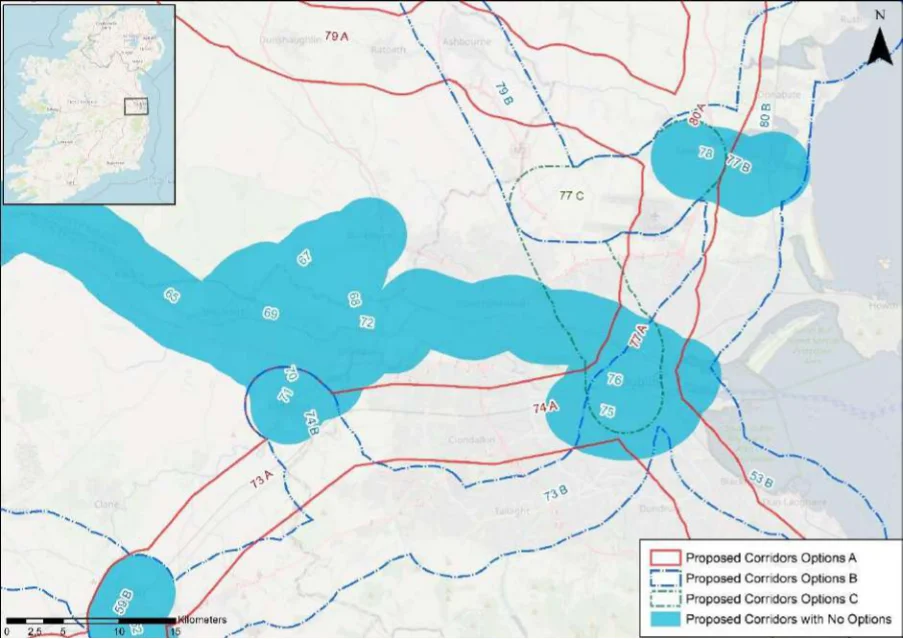
Table 70. Appraisal Relating to Corridor 70 Maynooth to Celbridge
Figure B20: Map of corridor options 70, 71 and 72
Summary of the Potential Effects Associated with Corridor 70 Maynooth to SEA Theme Celbridge
This corridor links Maynooth and Celbridge and crosses the Royal Canal pNHA near Biodiversity Maynooth. This designated site and the key sensitivities associated with the designation would need to be considered further when determining the final route during scheme development. Land take requirements are not known at this stage; however, it is anticipated the route would utilise existing infrastructure such as roads where practicable.
Population and Human Health
The corridor would link Maynooth (population c.14,585) with Celbridge (population c.20,290). The corridor would support an enhancement of accessibility to services and facilities in the settlements by active travel modes, promoting social inclusion and the quality of life of residents and supporting health and wellbeing. The corridor also has the potential to bring benefits for the visitor economy along the corridor and support community vitality.
Land use along the proposed corridor / within the area is variable and includes areas of Land and Soils urban fabric (artificial surfaces) in Maynooth and Celbridge and areas of pastures (agricultural areas) and non-irrigated arable land (agricultural areas) as per CORINE 2018. Should the route primarily involve the reallocation of road, loss of land and loss of productive agricultural land is unlikely to be significant.
Several watercourses occur along the route of the proposed corridor, including the River Water Lyreen and the River Liffey. The WFD status of these watercourses ranges between ‘good’ and ‘poor’ during the 2013-2018 monitoring period. The watercourses within the proposed corridor ranges from ‘at risk’ to ‘under review’.
The route occurs in an area considered to be of ‘Good’ air quality. The route will provide a Air Quality safe cycle route between Maynooth and Celbridge. This will promote a modal shift to active modes of travel which will in turn support ongoing improvements to air quality in the area.
Appendix B: Corridor option assessment tables
National Cycle Network SEA Environmental Report (Updated)
Summary of the Potential Effects Associated with Corridor 70 Maynooth to SEA Theme Impact Celbridge
The development of the corridor as part of the NCN would promote a shift to active modes Climate Change of travel from higher emission modes, including the private car. This will support a limitation of greenhouse gas emissions from transport. The corridor may cross (and potentially negatively / positively impact on) areas of flood risk. Whilst impacts on flood risk, and, more broadly, climate change adaptation, depends on the detailed route of the corridor and scheme design, there would be a need to ensure that the delivery of the corridor supports the resilience of the local area to the potential effects of climate change.
Positive
Cultural Heritage A range of cultural heritage assets are present within the proposed corridor, such as an
architectural feature (KD005-014----) and a gate lodge (Reg. No. 11805002). The development of the cycle corridor offers the potential for the rejuvenation and enhanced enjoyment of cultural heritage assets. However, the proposed corridor also has the potential to impact on the setting of archaeological assets which occur along the proposed corridor.
Uncertain
The proposed corridor, given it is likely to follow existing transport infrastructure, is unlikely Landscape to lead to significant impacts on landscape character. It also offers opportunities to enhance the quality of the public realm if high quality design and layouts are integrated within subsequent schemes. More broadly, the implementation of the corridor will support active travel modes, which are modes of transport with limited impacts on landscape character. Through promoting active travel modes, the corridor also offers opportunities to support an enhanced understanding and enjoyment of the special qualities and intrinsic character of the landscape in the vicinity of the corridor.
Positive
Appendix B: Corridor option assessment tables AECOM
National Cycle Network
Table 71. Appraisal Relating to Corridor 71 Leixlip to Celbridge
SEA Theme Summary of the Potential Effects Associated with Corridor 71 Leixlip to Celbridge
| Biodiversity The corridor connects Leixlip and Celbridge. The corridor encompasses the Royal Canal pNHA and the Rye Water Valley/Carton SAC and pNHA near Leixlip. These designated sites and the key sensitivities associated with the designations would need to be considered further when determining the final route during scheme development. Land take requirements are not known at this stage; however, it is anticipated the route would utilise existing infrastructure such as roads where practicable. The corridor may also traverse areas of greenfield. | Uncertain |
|---|---|
| Population and The corridor would link Leixlip (population c.15,500) with Celbridge (population c.20,290). Human Health The corridor would support an enhancement of accessibility to services and facilities in the settlements by active travel modes, promoting social inclusion and the quality of life of residents and supporting health and wellbeing. The corridor also has the potential to bring benefits for the visitor economy along the corridor and support community vitality. | Positive |
| Land and Soils Land use along the proposed corridor / within the area is variable and includes areas of urban fabric (artificial surfaces) in Leixlip and Celbridge and areas of pastures (agricultural areas) and non-irrigated arable land (agricultural areas) as per CORINE 2018. Should the route primarily involve the reallocation of road, loss of land and loss of productive agricultural land is unlikely to be significant. Should the route require some land-take (from agriculture), the impact to likely to be significant / uncertain. | Uncertain |
| Water Several watercourses occur along the route of the proposed corridor, including the River Lyreen and the River Liffey. The WFD status of these watercourses ranges between ‘good’ and ‘poor’ during the 2013-2018 monitoring period. The watercourses within the proposed corridor ranges from ‘at risk’ to ‘under review’. | Uncertain |
| Air Quality The route occurs in an area considered to be of ‘Good’ air quality. The route will provide a safe cycle route between Leixlip and Celbridge. This will promote a modal shift to active modes of travel which will in turn support ongoing improvements to air quality in the area. | Positive |
| Climate Change The development of the corridor as part of the NCN would promote a shift to active modes of travel from higher emission modes, including the private car. This will support a limitation of greenhouse gas emissions from transport. The corridor may cross (and potentially negatively / positively impact on) areas of flood risk. Whilst impacts on flood risk, and, more broadly, climate change adaptation, depends on the detailed route of the corridor and scheme design, there would be a need to ensure that the delivery of the corridor supports the resilience of the local area to the potential effects of climate change. | Positive |
| Cultural Heritage A range of cultural heritage assets are present within the proposed corridor, such as a fulacht fia (KD011-062----) and a burial mound (KD011-060----). The development of the cycle corridor offers the potential for the rejuvenation and enhanced enjoyment of cultural heritage assets. However, the proposed corridor also has the potential to impact on the setting of archaeological assets which occur along the proposed corridor. | Uncertain |
| Landscape The proposed corridor, given it is likely to follow existing transport infrastructure, is unlikely to lead to significant impacts on landscape character. It also offers opportunities to enhance the quality of the public realm, if high quality design and layouts are integrated within subsequent schemes. More broadly, the implementation of the corridor will support active travel modes, which are modes of transport with limited impacts on landscape character. Through promoting active travel modes, the corridor also offers opportunities to support an enhanced understanding and enjoyment of the special qualities and intrinsic character of the landscape in the vicinity of the corridor. | Positive |
Appendix B: Corridor option assessment tables
National Cycle Network
Table 72. Appraisal Relating to Corridor 72 Dublin to Leixlip
SEA Theme Summary of the Potential Effects Associated with Corridor 72 Dublin to Leixlip
| Biodiversity The corridor follows the route of the Royal Canal pNHA, between Spencer Dock and Leixlip and crosses the Rye Water Valley/Carton SAC and pNHA at Leixlip. The corridor also includes the Liffey Valley pNHA, South Dublin Bay and River Tolka Estuary SPA, and North Dublin Bay pNHA. These designated sites and the key sensitivities associated with the designations would need to be considered further when determining the final route during scheme development. Land take requirements are not known at this stage; however, it is anticipated the route would utilise existing infrastructure such as cycleways where practicable (for example the Royal Canal Greenway which is located along the route of the corridor). | Uncertain |
|---|---|
| Population and The corridor would link Dublin with Leixlip (population c.15,500), supporting accessibility via Human Health active modes of travels for the Dublin communities located along the route. As such, the corridor will support accessibility to the services, facilities and amenities and job opportunities available in Dublin. In this respect an enhancement of accessibility by active travel modes will promote social inclusion and the quality of life of residents and support health and wellbeing. | Positive |
| Land and Soils Land use along the proposed corridor / within the area is variable and includes areas of urban fabric (artificial surfaces) and industrial or commercial units (artificial surfaces) in Leixlip and Dublin City and Suburbs and areas of pastures (agricultural areas) outside of Dublin as per CORINE 2018. Should the route primarily involve the reallocation of road / recreational walking amenity (Royal Canal) in an urban area, loss of land and loss of productive agricultural land is unlikely to be significant. | Uncertain |
| Water Several watercourses occur along the route of the proposed corridor, including the River Rye, River Liffey and the Royal Canal. The WFD status of these watercourses ranges between ‘good’ and ‘poor’ during the 2013-2018 monitoring period. The watercourses within the proposed corridor ranges from ‘at risk’ to ‘under review’. | Uncertain |
| Air Quality The route occurs in an area considered to be of ‘Good’ air quality. The route will provide a safe cycle route between Leixlip and Dublin City and Suburbs. This will promote a modal shift to active modes of travel which will in turn support ongoing improvements to air quality in the area. | Positive |
| Climate Change The development of the corridor as part of the NCN would promote a shift to active modes of travel from higher emission modes, including the private car. This will support a limitation of greenhouse gas emissions from transport. The corridor may cross (and potentially negatively/positively impact on) areas of flood risk. Whilst impacts on flood risk, and, more broadly, climate change adaptation, depends on the detailed route of the corridor and scheme design, there would be a need to ensure that the delivery of the corridor supports the resilience of the local area to the potential effects of climate change. | Positive |
| Cultural Heritage A range of cultural heritage assets are present within the proposed corridor, such as a fulacht fia (KD011-053----), ring ditch (DU013-047----) and a lock (DU013-047----). Given a part of the proposed corridor is located along a canal (Royal Canal), sensitive development of the corridor as a cycle route offers the potential for the rejuvenation and enhanced enjoyment of this heritage asset. However, the proposed corridor also has the potential to impact on the setting of other cultural heritage assets (e.g., archaeological remains) which may occur along the proposed corridor. | Uncertain |
| Landscape The proposed corridor, given it is likely to follow existing transport infrastructure, is unlikely to lead to significant impacts on landscape character. It also offers opportunities to enhance the quality of the public realm, if high quality design and layouts are integrated within subsequent schemes. More broadly, the implementation of the corridor will support active travel modes, which are modes of transport with limited impacts on landscape character. Through promoting active travel modes, the corridor also offers opportunities to support an enhanced understanding and enjoyment of the special qualities and intrinsic character of the landscape in the vicinity of the corridor. | Positive |
Appendix B: Corridor option assessment tables
National Cycle Network
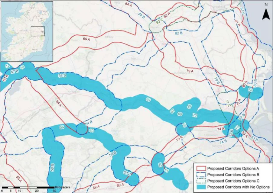
Table 73. Appraisal Relating to Corridor 73 Naas to Dublin
Figure B21: Map of corridor options 73, 74 and 75
| Option A | B |
|---|---|
| = | = |
| = | = |
SEA Theme Summary of the Potential Effects Associated with Corridor 73 Naas to Dublin
Option A: The corridor option runs along the route of the Grand Canal pNHA. No other Biodiversity designated sites are located in the vicinity the corridor. The designated site and the key sensitivities associated with the designation would need to be considered further when determining the final route during scheme development. Land take requirements are not known at this stage; however, it is anticipated the route would utilise existing infrastructure such as cycleways where practicable (for example the Grand Canal Greenway which is located along the route of the corridor). Option B: The corridor includes the Grand Canal pNHA, Kilteel Wood pNHA, Lugmore Glen pNHA, and Dodder Valley pNHA. The corridor crosses the Grand Canal pNHA near Harold’s Cross. The designated sites and the key sensitivities associated with the designations would need to be considered further when determining the final route during scheme development. Land take requirements are not known at this stage; however, it is anticipated the route would utilise existing infrastructure such as roads and cycleways where practicable.
Population and Human Health
The two options would link Naas (population c.21,400) with Dublin, supporting accessibility via active modes of travels for the communities located along the routes (including those in the Dublin suburbs). As such, the options will support accessibility to the services, facilities and amenities and job opportunities available in Dublin and to and from the communities along the route. In this respect an enhancement of accessibility by active travel modes will promote social inclusion and the quality of life of residents and support health and wellbeing. Option B will also link Kill (population c.3,348) and a number of smaller settlements, whilst Option A will also provide links for Sallins (population c.5,850). The tourism potential of the corridor has the potential to be better realised through the use of the Grand Canal through Option A.
Appendix B: Corridor option assessment tables
National Cycle Network SEA Environmental Report (Updated)
Option
SEA Theme Summary of the Potential Effects Associated with Corridor 73 Naas to Dublin A B
| Land and Soils Option A: Land use along the proposed corridor / within the area is variable and includes areas of urban fabric (artificial surfaces) and industrial or commercial units (artificial surfaces) in Naas and Dublin City and Suburbs and areas of pastures (agricultural areas) outside of Dublin as per CORINE 2018. Should the route primarily involve the reallocation of road / recreational amenity infrastructure, loss of land and loss of productive agricultural land is unlikely to be significant. Option B: Land use along the proposed corridor / within the area is variable and includes areas of urban fabric (artificial surfaces) and industrial or commercial units (artificial surfaces) in Naas and Dublin City and Suburbs and areas of pastures (agricultural areas) outside of Dublin as per CORINE 2018. Should the route primarily involve the reallocation of road in an urban area, loss of land and loss of productive agricultural land is unlikely to be significant. | = | = |
|---|---|---|
| Water Option A: Several watercourses occur along the route of the proposed corridor, including the River Liffey, River Morell, River Camac, River Poddle and the Grand Canal. The WFD status of these watercourses ranges between ‘good’ and ‘poor’ during the 2013-2018 monitoring period. The watercourses within the proposed corridor ranges from ‘at risk’ to ‘under review’. Option B: Several watercourses occur along the route of the proposed corridor, including the River Liffey, River Morell, Kill River, River Camac, River Dodder and the Grand Canal. The WFD status of these watercourses ranges between ‘good’ and ‘poor’ during the 2013-2018 monitoring period. The watercourses within the proposed corridor ranges from ‘at risk’ to ‘under review’. | = | = |
| Air Quality Options A & B: The route occurs in an area considered to be of ‘Good’ air quality. The route will provide a safe cycle route between Naas and Dublin City and Suburbs. This will promote a modal shift to active modes of travel which will in turn support ongoing improvements to air quality in the area. | = | = |
| Climate The development of the corridor options as part of the NCN would promote a shift to active Change modes of travel from higher emission modes, including the private car. This will support a limitation of greenhouse gas emissions from transport. The corridor options may cross (and potentially negatively/positively impact on) areas of flood risk. Whilst impacts on flood risk, and, more broadly, climate change adaptation, depends on the detailed route of the corridor and scheme design, there would be a need to ensure that the delivery of the corridor options supports the resilience of the local area to the potential effects of climate change. | = | = |
| Cultural Option A: A range of cultural heritage assets are present within the proposed corridor, such Heritage as a house (Reg. No. 11811026), bridge (Reg. No. 119014060 and an outbuilding (Reg. No. 11204058). Given a part of the proposed corridor is located along a canal (Grand Canal), sensitive development of the corridor as a cycle route offers the potential for the rejuvenation and enhanced enjoyment of this heritage asset. However, the proposed corridor also has the potential to impact on the setting of other cultural heritage assets (e.g., archaeological remains) which may occur along the proposed corridor. Option B: A range of cultural heritage assets are present within the proposed corridor, such as a standing stone (KD019-059----), habitation site (KD020-027----) and a house (Reg. No. 11217003). The development of the cycle corridor offers the potential for the rejuvenation and enhanced enjoyment of cultural heritage assets. However, the proposed corridor also has the potential to impact on the setting of archaeological assets which occur along the proposed corridor. Option A is likely to perform more favourably in relation to this SEA theme, as it aligns along existing infrastructure (Royal Canal) and would rejuvenation and connect cultural heritage assets along this route. | 1 | 2 |
| Landscape The corridor options, given they largely follow existing transport corridors, are unlikely to lead to significant impacts on landscape character. They also offer opportunities to enhance the quality of the public realm, if high quality design and layouts are integrated within subsequent schemes. More broadly, the corridor options will support active travel modes, which are modes of transport with limited impacts on landscape character. Through promoting active travel modes, the corridor options will also support an enhanced understanding and enjoyment of the special qualities and intrinsic character of the landscape. | = | = |
Appendix B: Corridor option assessment tables AECOM
National Cycle Network
Table 74. Appraisal Relating to Corridor 74 Celbridge to Dublin
SEA Theme Summary of the Potential Effects Associated with Corridor 74 Celbridge to Dublin
| Biodiversity Option A: The corridor option runs along the route of the Grand Canal pNHA. No other designated sites are located within the corridor. The designated site and the key sensitivities associated with the designation would need to be considered further when determining the final route during scheme development. Land take requirements are not known at this stage; however, it is anticipated the route would utilise existing infrastructure such as cycleways where practicable (for example the Grand Canal Greenway which is located along a section of the route of the corridor). Option B: The corridor option includes Grand Canal pNHA, Lugmore Glen pNHA, and Dodder Valley pNHA. The corridor crosses the Grand Canal pNHA near Harold’s Cross and at Straleek. The designated sites and the key sensitivities associated with the designation would need to be considered further when determining the final route during scheme development. Land take requirements are not known at this stage; however, it is anticipated the route would utilise existing infrastructure such as roads where practicable. | = | = |
|---|---|---|
| Population The two options would link Celbridge (population c.20,290) with Dublin, supporting and Human accessibility via active modes of travels for the communities located along the routes (including Health those in the Dublin suburbs). As such, the options will support accessibility to the services, facilities and amenities and job opportunities available in Dublin and to and from the communities along the route. In this respect an enhancement of accessibility by active travel modes will promote social inclusion and the quality of life of residents and support health and wellbeing. Option B will also link Newcastle (population c.3,090), whilst Option A will utilise the Grand Canal. The tourism potential of the corridor has the potential to be better realised through the use of the Grand Canal through Option A. | 1 | 2 |
| Land and Soils Option A: Land use along the proposed corridor / within the area is variable and includes areas of urban fabric (artificial surfaces) and industrial or commercial units (artificial surfaces) in Celbridge and Dublin City and Suburbs and areas of pastures (agricultural areas) outside of Dublin as per CORINE 2018. Should the route primarily involve the reallocation of road / recreational amenity infrastructure (Grand Canal), loss of land and loss of productive agricultural land is unlikely to be significant. Option B: Land use along the proposed corridor / within the area is variable and includes areas of urban fabric (artificial surfaces) and industrial or commercial units (artificial surfaces) in Celbridge, Saggart and Dublin City and Suburbs and areas of pastures (agricultural areas) outside of Dublin as per CORINE 2018. Should the route primarily involve the reallocation of road in an urban area, loss of land and loss of productive agricultural land is unlikely to be significant. Option A is likely to perform more favourably in relation to this SEA theme as it aligns more along existing infrastructure (Grand Canal) and would require less land-take (from agriculture). | 1 | 2 |
| Water Option A: Several watercourses occur along the route of the proposed corridor, including the River Liffey, River Camac and the Grand Canal. The WFD status of these watercourses ranges between ‘good’ and ‘poor’ during the 2013-2018 monitoring period. The watercourses within the proposed corridor ranges from ‘at risk’ to ‘under review’. Option B: Several watercourses occur along the route of the proposed corridor, including the River Liffey, River Camac, River Dodder and the Grand Canal. The WFD status of these watercourses ranges between ‘good’ and ‘poor’ during the 2013-2018 monitoring period. The watercourses within the proposed corridor ranges from ‘at risk’ to ‘under review’. | = | = |
| Air Quality Options A & B: The route occurs in an area considered to be of ‘Good’ air quality. The route will provide a safe cycle route between Celbridge and Dublin City and Suburbs. This will promote a modal shift to active modes of travel which will in turn support ongoing improvements to air quality in the area. | = | = |
| Climate The development of the corridor options as part of the NCN would promote a shift to active Change modes of travel from higher emission modes, including the private car. This will support a limitation of greenhouse gas emissions from transport. The corridor options may cross (and potentially negatively/positively impact on) areas of flood risk. Whilst impacts on flood risk, and, more broadly, climate change adaptation, depends on the detailed route of the corridor and scheme design, there would be a need to ensure that the delivery of the corridor options supports the resilience of the local area to the potential effects of climate change. | = | = |
Appendix B: Corridor option assessment tables
National Cycle Network SEA Environmental Report (Updated)
| Option A | B |
|---|---|
| 1 | 2 |
| = | = |
SEA Theme Summary of the Potential Effects Associated with Corridor 74 Celbridge to Dublin
Cultural Heritage
Option A: A range of cultural heritage assets are present within the proposed corridor, such as a bridge (Reg. No. 11207002) and (Reg. No. 11204052). Given a part of the proposed corridor is located along a canal (Grand Canal), sensitive development of the corridor as a cycle route offers the potential for the rejuvenation and enhanced enjoyment of this heritage asset. However, the proposed corridor also has the potential to impact on the setting of other cultural heritage assets (e.g., archaeological remains) which may occur along the proposed corridor. Option B: A range of cultural heritage assets are present within the proposed corridor, such as a bridge (Reg. No. 11207002), ringfort (DU020-002----) and a habitation site (DU021-023- ---). The development of the cycle corridor offers the potential for the rejuvenation and enhanced enjoyment of cultural heritage assets. However, the proposed corridor also has the potential to impact on the setting of archaeological assets which occur along the proposed corridor. Option A is likely to perform more favourably in relation to this SEA theme, as it aligns along existing infrastructure (Royal Canal) and would rejuvenation and connect cultural heritage assets along this route.
The corridor options, given they largely follow existing transport corridors, are unlikely to lead Landscape to significant impacts on landscape character. They also offer opportunities to enhance the quality of the public realm, if high quality design and layouts are integrated within subsequent schemes. More broadly, the corridor options will support active travel modes, which are modes of transport with limited impacts on landscape character. Through promoting active travel modes, the corridor options will also support an enhanced understanding and enjoyment of the special qualities and intrinsic character of the landscape.
Appendix B: Corridor option assessment tables AECOM
National Cycle Network
Table 75. Appraisal Relating to Corridor 75 Grand Canal Greenway
Summary of the Potential Effects Associated with Corridor 75 Grand Canal SEA Theme Greenway
| Biodiversity The corridor runs along the route of the Grand Canal pNHA from Hanover Quay to near Rialto. No other designated sites are located within the corridor. The designated site and the key sensitivities associated with the designation would need to be considered further when determining the final route during scheme development. Land take requirements are not known at this stage; however, it is anticipated the route would utilise existing infrastructure such as along existing roads where practicable. | Uncertain |
|---|---|
| Population and The corridor would link Dublin with the west along the Grand Canal, supporting accessibility Human Health via active modes of travels for the communities located along the route (including in the Dublin suburbs). As such, the corridor will support accessibility to the services, facilities and amenities and job opportunities available in Dublin and neighbourhoods along the corridor. In this respect an enhancement of accessibility by active travel modes will promote social inclusion and the quality of life of residents and support health and wellbeing. The use of the Grand Canal as a greenway will support the tourism potential of the area and bring benefits for the visitor economy. | Positive |
| Land and Soils Land use along the proposed corridor / within the area is primarily urban fabric (artificial surfaces) and industrial or commercial units (artificial surfaces) in Dublin City, as per CORINE 2018. Should the route primarily involve the reallocation of road / recreational walking amenity infrastructure (Grand Canal) in an urban area, loss of land and loss of productive agricultural land is very unlikely. | Uncertain |
| Water The Grand Canal is along the route of the proposed corridor. There is no WFD status for the Grand Canal. | Uncertain |
| Air Quality The route occurs in an area considered to be of ‘Good’ air quality. The route will provide a safe cycle route in Dublin City. This will promote a modal shift to active modes of travel which will in turn support ongoing improvements to air quality in the area. | Positive |
| Climate Change The development of the corridor as part of the NCN would promote a shift to active modes of travel from higher emission modes, including the private car. This will support a limitation of greenhouse gas emissions from transport. The corridor may cross (and potentially negatively/positively impact on) areas of flood risk. Whilst impacts on flood risk, and, more broadly, climate change adaptation, depends on the detailed route of the corridor and scheme design, there would be a need to ensure that the delivery of the corridor supports the resilience of the local area to the potential effects of climate change. | Positive |
| Cultural Heritage A range of cultural heritage assets are present within the proposed corridor, such as a bridge (Reg. No. 50080203) and lock (Reg. No. 50100595). Given a part of the proposed corridor is located along the canal (Grand Canal), sensitive development of the corridor as a cycle route offers the potential for the rejuvenation and enhanced enjoyment of these heritage assets. | Uncertain |
| Landscape The proposed corridor, given it is likely to follow existing transport infrastructure, is unlikely to lead to significant impacts on landscape character. It also offers opportunities to enhance the quality of the public realm, if high quality design and layouts are integrated within subsequent schemes. More broadly, the implementation of the corridor will support active travel modes, which are modes of transport with limited impacts on landscape character. Through promoting active travel modes, the corridor also offers opportunities to support an enhanced understanding and enjoyment of the special qualities and intrinsic character of the landscape in the vicinity of the corridor. | Positive |
Appendix B: Corridor option assessment tables
National Cycle Network
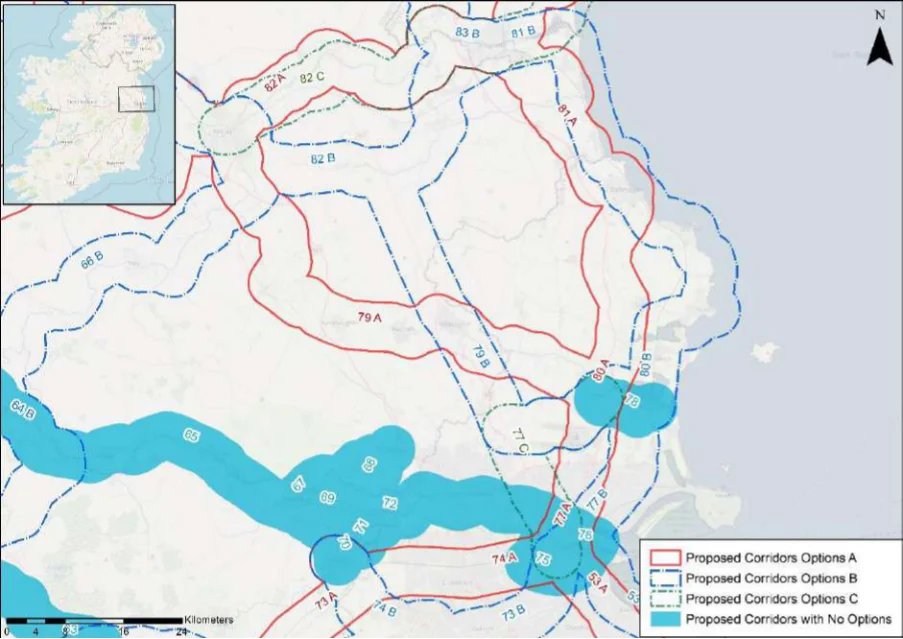
Table 76. Appraisal Relating to Corridor 76 Dublin Port to Heuston Station via Connolly Station
Figure B22: Map of corridor options 76, 77 and 78
Summary of the Potential Effects Associated with Corridor 76 Dublin Port to SEA Theme Heuston Station via Connolly Station
The corridor links Dublin Port to Heuston Station, through the IFSC. The corridor crosses Biodiversity the Royal Canal pNHA near Spencer Dock. South Dublin Bay and River Tolka Estuary SPA and North Dublin Bay pNHA occur within the corridor. The designated sites and the key sensitivities associated with the designation would need to be considered further when determining the final route during scheme development. Land take requirements are not known at this stage; however it is anticipated the route would utilise existing infrastructure such as along existing roads where practicable.
Population and Human Health
The corridor would link key city transport nodes and employment centres in Dublin, including Heuston railway station, Connolly railway station, the IFSC and Dublin Port along the River Liffey. This will support accessibility via active modes of travels to these important transport nodes and provide a key city centre link for cyclists. These linkages and the use of the River Liffey corridor will also support sustainable tourism and bring benefits for the visitor economy.
Land use along the proposed corridor / within the area is primarily urban fabric (artificial Land and Soils surfaces) and industrial or commercial units (artificial surfaces) in Dublin City as per CORINE 2018. Should the route primarily involve the reallocation of road in an urban area, loss of land and loss of productive agricultural land is very unlikely.
The River Liffey is along the route of the proposed corridor. There WFD status of the River Water Liffey is ‘good’ and ‘under review’.
The route occurs in an area considered to be of ‘Good’ air quality. The route will provide a Air Quality safe cycle route in Dublin City. This will promote a modal shift to active modes of travel which will in turn support ongoing improvements to air quality in the area.
The development of the corridor as part of the NCN would promote a shift to active modes Climate Change of travel from higher emission modes, including the private car. This will support a limitation of greenhouse gas emissions from transport. The corridor may cross (and potentially negatively/positively impact on) areas of flood risk. Whilst impacts on flood risk, and, more broadly, climate change adaptation, depends on the detailed route of the corridor and scheme design, there would be a need to ensure that the
Appendix B: Corridor option assessment tables
National Cycle Network SEA Environmental Report (Updated)
Summary of the Potential Effects Associated with Corridor 76 Dublin Port to SEA Theme Heuston Station via Connolly Station
Impact
delivery of the corridor supports the resilience of the local area to the potential effects of climate change.
Cultural Heritage A range of cultural heritage assets are present within the proposed corridor, such as a Quay
(Reg. No. 50060352), sea wall (DU018-020505-) and a water tower (Reg. No. 50120264). The development of the cycle corridor offers the potential for the rejuvenation and enhanced enjoyment of cultural heritage assets in the City.
Uncertain
The proposed corridor, given it is likely to follow existing transport infrastructure, is unlikely Landscape to lead to significant impacts on landscape character. It also offers opportunities to enhance the quality of the public realm, if high quality design and layouts are integrated within subsequent schemes. More broadly, the implementation of the corridor will support active travel modes, which are modes of transport with limited impacts on landscape character. Through promoting active travel modes, the corridor also offers opportunities to support an enhanced understanding and enjoyment of the special qualities and intrinsic character of the landscape in the vicinity of the corridor.
Positive
Appendix B: Corridor option assessment tables AECOM
National Cycle Network
Table 77. Appraisal Relating to Corridor 77 Swords to Dublin
SEA Theme Summary of the Potential Effects Associated with Corridor 77 Swords to Dublin
| Biodiversity Option A crosses the Royal Canal pNHA at Drumcondra. Santry Demesne pNHA and Malahide Estuary SAC, SPA and pNHA are located within the corridor. Option B crosses the Royal Canal pNHA at Seville Place. South Dublin Bay and River Tolka Estuary SPA, North Dublin Bay pNHA, Sluice River Marsh pNHA, Feltrim Hill pNHA, and Malahide Estuary SAC, SPA and pNHA are located within the corridor. Option C crosses Royal Canal pNHA at Phibsborough. Malahide Estuary SAC, SPA and pNHA is located within the corridor. The designated sites and the key sensitivities associated with the designation would need to be considered further when determining the final route during scheme development. Land take requirements are not known at this stage; however it is anticipated that all routes would utilise existing infrastructure such as along existing roads where practicable. Option C could potentially traverse some greenfield areas where infrastructure is not available. | = | = | 2 |
|---|---|---|---|
| Population The two options would link Swords (population c.39,250) with Dublin, supporting accessibility and Human via active modes of travels for the communities located along the routes (including those in Health the Dublin suburbs). As such, the options will support accessibility to the services, facilities and amenities and job opportunities available in Dublin and to and from the communities along the route. In this respect an enhancement of accessibility by active travel modes will promote social inclusion and the quality of life of residents and support health and wellbeing. In terms of the differences between the options, Option A will support a more direct sustainable transport link to Dublin Airport from Dublin City centre, whilst Option B will provide a link with Malahide (population c.16,550). | = | = | = |
| Land and Option A: Land use along the proposed corridor / within the area is primarily urban fabric Soils (artificial surfaces) and industrial or commercial units (artificial surfaces) in Swords, Dublin Airport and Dublin City and Suburbs and areas of pastures (agricultural areas) in North Dublin, as per CORINE 2018. Should the route primarily involve the reallocation of road in an urban area, loss of land and loss of productive agricultural land is unlikely. Option B: Land use along the proposed corridor / within the area is primarily urban fabric (artificial surfaces) and industrial or commercial units (artificial surfaces) in Swords, Malahide and Dublin City and Suburbs and areas of pastures (agricultural areas) in North Dublin, as per CORINE 2018. Should the route primarily involve the reallocation of road in an urban area, loss of land and loss of productive agricultural land is unlikely. Option C: Land use along the proposed corridor / within the area is primarily urban fabric (artificial surfaces) and industrial or commercial units (artificial surfaces) in Swords and Dublin City and Suburbs. Should the route primarily involve the reallocation of road in an urban area, loss of land and loss of productive agricultural land is unlikely. | = | = | = |
| Water Option A: Several watercourses occur along the route of the proposed corridor, including the River Liffey, Tolka River, Sluice River and the Mayne River. The WFD status of these watercourses ranges between ‘good’ and ‘poor’ during the 2013-2018 monitoring period. The watercourses within the proposed corridor ranges from ‘at risk’ to ‘under review’. Option B: Several watercourses occur along the route of the proposed corridor, including the River Liffey, Royal Canal, Tolka Estuary, Santry River, Mayne River and the Gaybrooks Stream. The WFD status of these watercourses ranges between ‘good’ and ‘poor’ during the 2013-2018 monitoring period. The watercourses within the proposed corridor ranges from ‘at risk’ to ‘under review’. Option C: Several watercourses occur along the route of the proposed corridor, including the River Liffey, Tolka River and the River Ward. The WFD status of these watercourses ranges between ‘good’ and ‘poor’ during the 2013-2018 monitoring period. The watercourses within the proposed corridor ranges from ‘at risk’ to ‘under review’. | = | = | = |
| Air Quality Options A & B & C: The route occurs in an area considered to be of ‘Good’ air quality. The route will provide a safe cycle route between Swords and Dublin City and Suburbs. This will promote a modal shift to active modes of travel which will in turn support ongoing improvements to air quality in the area. | = | = | = |
| Climate The development of the corridor options as part of the NCN would promote a shift to active Change modes of travel from higher emission modes, including the private car. This will support a limitation of greenhouse gas emissions from transport. The corridor options may cross (and potentially negatively / positively impact on) areas of flood risk. Whilst impacts on flood risk, and, more broadly, climate change adaptation, depends on the detailed route of the corridor and scheme design, there would be a need to ensure that the delivery of the corridor options supports the resilience of the local area to the potential effects of climate change. | = | = | = |
Appendix B: Corridor option assessment tables
National Cycle Network SEA Environmental Report (Updated)
| A | Option B | C |
|---|---|---|
| = | = | = |
| = | = | = |
SEA Theme Summary of the Potential Effects Associated with Corridor 77 Swords to Dublin
Option A: A range of cultural heritage assets are present within the proposed corridor, such as a house (Reg. No. 11349004) and a structure (DU011-154----). Option B: A range of cultural heritage assets are present within the proposed corridor, such as a statue (Reg. No. 50120134) and a bridge (DU018-006----). Option C: A range of cultural heritage assets are present within the proposed corridor, such as a habitation site (DU018-020833-) and a bridge (DU018-002----). The development of these cycle corridor offers the potential for the rejuvenation and enhanced enjoyment of cultural heritage assets. However, the proposed corridor also has the potential to impact on the setting of archaeological assets which occur along theses proposed corridors.
Heritage
The corridor options, given they largely follow existing transport corridors, are unlikely to lead Landscape to significant impacts on landscape character. They also offer opportunities to enhance the quality of the public realm, if high quality design and layouts are integrated within subsequent schemes. More broadly, the corridor options will support active travel modes, which are modes of transport with limited impacts on landscape character. Through promoting active travel modes, the corridor options will also support an enhanced understanding and enjoyment of the special qualities and intrinsic character of the landscape.
Appendix B: Corridor option assessment tables AECOM
National Cycle Network
Table 78. Appraisal Relating to Corridor 78 Swords to Malahide
SEA Theme Summary of the Potential Effects Associated with Corridor 78 Swords to Malahide
| Biodiversity The corridor links Swords and Malahide. Feltrim Hill pNHA, and Malahide Estuary SAC, SPA and pNHA are located within the vicinity of the corridor. The designated sites and the key sensitivities associated with the designation would need to be considered further when determining the final route during scheme development. Land take requirements are not known at this stage; however it is anticipated the route would utilise existing infrastructure such as roads where practicable. | Uncertain |
|---|---|
| Population The corridor will link Swords (population c.39,250) and Malahide (population c.16,550). The and Human corridor would support an enhancement of accessibility to services and facilities in the Health settlements by active travel modes, promoting social inclusion and the quality of life of residents and supporting health and wellbeing. The corridor also has the potential to bring benefits for the visitor economy along the corridor and support community vitality. | Positive |
| Land and Land use along the proposed corridor / within the area is primarily urban fabric (artificial Soils surfaces) and industrial or commercial units (artificial surfaces) in Swords and Malahide and areas of complex cultivation patterns (agricultural areas), along the coastline, as per CORINE 2018. Should the route primarily involve the reallocation of road, loss of land and loss of productive agricultural land is unlikely to be significant. | Uncertain |
| Water Several watercourses occur along the route of the proposed corridor, including the River Liffey, Royal Canal, Tolka River, Santry River, Mayne River and the Gaybrooks Stream. The WFD status of these watercourses ranges between ‘good’ and ‘poor’ during the 2013-2018 monitoring period. The watercourses within the proposed corridor ranges from ‘at risk’ to ‘under review’. | Uncertain |
| Air Quality The route occurs in an area considered to be of ‘Good’ air quality. The route will provide a safe cycle route between Swords and Malahide. This will promote a modal shift to active modes of travel which will in turn support ongoing improvements to air quality in the area. | Positive |
| Climate The development of the corridor as part of the NCN would promote a shift to active modes of Change travel from higher emission modes, including the private car. This will support a limitation of greenhouse gas emissions from transport. The corridor may cross (and potentially negatively/positively impact on) areas of flood risk. Whilst impacts on flood risk, and, more broadly, climate change adaptation, depends on the detailed route of the corridor and scheme design, there would be a need to ensure that the delivery of the corridor supports the resilience of the local area to the potential effects of climate change. | Positive |
| Cultural A range of cultural heritage assets are present within the proposed corridor, such as a gate Heritage lodge (Reg. No. 11344044) and a school building (Reg. No. 11344018). The development of the cycle corridor offers the potential for the rejuvenation and enhanced enjoyment of cultural heritage assets. However, the proposed corridor also has the potential to impact on the setting of archaeological assets which occur along the proposed corridor. | Uncertain |
| Landscape The proposed corridor, given it is likely to follow existing transport infrastructure, is unlikely to lead to significant impacts on landscape character. It also offers opportunities to enhance the quality of the public realm, if high quality design and layouts are integrated within subsequent schemes. More broadly, the implementation of the corridor will support active travel modes, which are modes of transport with limited impacts on landscape character. Through promoting active travel modes, the corridor also offers opportunities to support an enhanced understanding and enjoyment of the special qualities and intrinsic character of the landscape in the vicinity of the corridor. | Positive |
Appendix B: Corridor option assessment tables
National Cycle Network
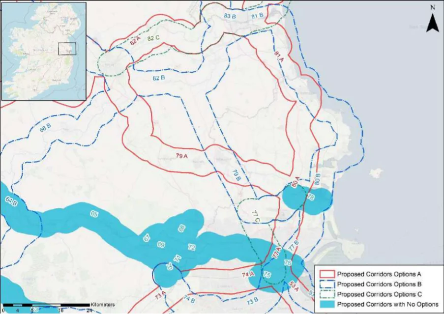
Table 79. Appraisal Relating to Corridor 79 Navan to Swords
Figure B23: Map of corridor options 79, 80, 81 and 82
| Option A | B |
|---|---|
| = | = |
| 1 | 2 |
SEA Theme Summary of the Potential Effects Associated with Corridor 79 Navan to Swords
Option A: The corridor follows River Boyne and River Blackwater SAC and SPA from Navan Biodiversity to Malahide Estuary SAC, SPA and pNHA. The Balrath and Woods pNHA is also located within the corridor option. The designated sites and the key sensitivities associated with these designations would need to be considered further when determining the final route during scheme development.Land take requirements are not known at this stage; however, it is anticipated the route would utilise existing infrastructure such as roads. Option B: The corridor follows the River Boyne and River Blackwater SAC and SPA from Navan to near Castletown Tara and Balreask Old, where the route crosses the designated site. The Malahide Estuary SAC, SPA and pNHA, Balrath and Woods pNHA are also located within the corridor. The designated sites and the key sensitivities associated with the designation would need to be considered further when determining the final route during scheme development.Land take requirements are not known at this stage; however, it is anticipated the route would utilise existing infrastructure such as roads where practicable.
Population and Human Health
The corridor options would link Navan (population c.30,170) with Swords (population c.39,250). Option A would link the two towns via Dunshaughlin (population c.4,035), Ratoath (population c.9,530) and Ashbourne (population c.12,680), whilst Option B would link the two towns via Kentstown (population c.1,179). The corridor options would support an enhancement of accessibility to services and facilities in the settlements by active travel modes, promoting social inclusion and the quality of life of residents and supporting health and wellbeing. The corridor also has the potential to bring benefits for the visitor economy along the corridor and support community vitality. Given the option links more communities with larger populations, Option A is likely to perform more favourably than Option B in relation to this SEA theme.
Appendix B: Corridor option assessment tables
National Cycle Network SEA Environmental Report (Updated)
Option
SEA Theme Summary of the Potential Effects Associated with Corridor 79 Navan to Swords A B
| Land and Soils Option A: Land use along the proposed corridor / within the area is variable and includes areas of urban fabric (artificial surfaces) and industrial or commercial units (artificial surfaces) in Navan, Kentstown, Ashbourne and Swords and areas of pastures (agricultural areas) and non-irrigated arable land (agricultural areas) as per CORINE 2018. Should the route primarily involve the reallocation of road, loss of land and loss of productive agricultural land is unlikely to be significant. Option B: Land use along the proposed corridor / within the area is variable and includes areas of urban fabric (artificial surfaces) and industrial or commercial units (artificial surfaces) in Navan, Dunshaughlin, Ratoath, Ashbourne and Swords and areas of pastures (agricultural areas) and non-irrigated arable land (agricultural areas) as per CORINE 2018. Should the route primarily involve the reallocation of road, loss of land and loss of productive agricultural land is unlikely to be significant. | = | = |
|---|---|---|
| Water Option A: Several watercourses occur along the route of the proposed corridor, including the River Boyne, River Skane and the Broadmeadow River. The WFD status of these watercourses ranges between ‘good’ and ‘poor’ during the 2013-2018 monitoring period. The watercourses within the proposed corridor ranges from ‘at risk’ to ‘under review’. Option B: Several watercourses occur along the route of the proposed corridor, including the River Boyne, River Nanny, Hurley River, Broadmeadow River, River Ward and the River Sluice. The WFD status of these watercourses ranges between ‘good’ and ‘poor’ during the 2013-2018 monitoring period. The watercourses within the proposed corridor ranges from ‘at risk’ to ‘under review’. | = | = |
| Air Quality Options A & B: The route occurs in an area considered to be of ‘Good’ air quality. The route will provide a safe cycle route between Navan and Swords. This will promote a modal shift to active modes of travel which will in turn support ongoing improvements to air quality in the area. | = | = |
| Climate The development of the corridor options as part of the NCN would promote a shift to active Change modes of travel from higher emission modes, including the private car. This will support a limitation of greenhouse gas emissions from transport. Option A, given it links more communities with larger populations, will however bring additional benefits in relation to this element of climate change mitigation. The corridor options may cross (and potentially negatively/positively impact on) areas of flood risk. Whilst impacts on flood risk, and, more broadly, climate change adaptation, depends on the detailed route of the corridor and scheme design, there would be a need to ensure that the delivery of the corridor options supports the resilience of the local area to the potential effects of climate change. | 1 | 2 |
| Cultural Option A: A range of cultural heritage assets are present within the proposed corridor, such Heritage as a church (ME025-036----) and a field system (ME044-052----). The development of the cycle corridor offers the potential for the rejuvenation and enhanced enjoyment of cultural heritage assets. However, the proposed corridor also has the potential to impact on the setting of archaeological assets which occur along the proposed corridor. Option B: A range of cultural heritage assets are present within the proposed corridor, such as a font (ME025-041001-0) and an enclosure (ME032-090----). The development of the cycle corridor offers the potential for the rejuvenation and enhanced enjoyment of cultural heritage assets. However, the proposed corridor also has the potential to impact on the setting of archaeological assets which occur along the proposed corridor. | = | = |
| Landscape The corridor options, given they largely follow existing transport corridors, are unlikely to lead to significant impacts on landscape character. They also offer opportunities to enhance the quality of the public realm, if high quality design and layouts are integrated within subsequent schemes. More broadly, the corridor options will support active travel modes, which are modes of transport with limited impacts on landscape character. Through promoting active travel modes, the corridor options will also support an enhanced understanding and enjoyment of the special qualities and intrinsic character of the landscape. | = | = |
Appendix B: Corridor option assessment tables AECOM
National Cycle Network
Table 80. Appraisal Relating to Corridor 80 Balbriggan to Swords
SEA Theme Summary of the Potential Effects Associated with Corridor 80 Balbriggan to Swords
| Biodiversity Option A: Within the corridor there are two SACs, two SPAs and four pNHA/NHAs. These include the Malahide Estuary SAC, SPA and pNHA, Rogerstown Estuary SAC, SPA and pNHA, Bog of the Ring pNHA and the Knock Lake pNHA. These designated sites and the key sensitivities associated with the designations would need to be considered further when determining the final route during scheme development. Land take requirements are not known at this stage; however, it is anticipated the route would utilise existing infrastructure such as roads where practicable. Option B: Within the corridor there are three SACs, three SPAs, and four pNHA/NHAs. These include the Malahide Estuary SAC, SPA and pNHA, Rogerstown Estuary SAC, SPA and pNHA, Bog of the Ring pNHA and the Knock Lake pNHA. These designated sites and the key sensitivities associated with the designations would need to be considered further when determining the final route during scheme development. Land take requirements are not known at this stage; however, it is anticipated the route would utilise existing infrastructure such as roads and cycleways where practicable. Option B would also traverse areas of greenfield. | 1 | 2 |
|---|---|---|
| Population The corridor options would link Balbriggan (population c.21,720) with Swords (population and Human c.39,250). Option A would link the two towns with Balrothery (population c.2,020), whilst Option Health B would link the two towns along the coast via Skerries (population c.10,043), Rush (population c.9,940) and Donabate (population c.7,440) and Malahide (population c.16,550). The corridor options would support an enhancement of accessibility to services and facilities in the settlements by active travel modes, promoting social inclusion and the quality of life of residents and supporting health and wellbeing. The corridor options also have the potential to bring benefits for the visitor economy along the corridor and support community vitality. Given Option B links more communities with larger populations, the option is likely to perform better than Option A in relation to this SEA theme. Option B, given it follows the coast also offers additional potential relating to tourism and the visitor economy. | 2 | 1 |
| Land and Option A: Land use along the proposed corridor / within the area is variable and includes areas Soils of urban fabric (artificial surfaces) and industrial or commercial units (artificial surfaces) in Balbriggan, Coldwinters and Swords and areas of pastures (agricultural areas) and non- irrigated arable land (agricultural areas) as per CORINE 2018. Should the route primarily involve the reallocation of road, loss of land and loss of productive agricultural land is unlikely to be significant. Option B: Land use along the proposed corridor / within the area is variable and includes areas of urban fabric (artificial surfaces) and industrial or commercial units (artificial surfaces) in Balbriggan, Skerries, Rush, Malahide and Swords and areas of pastures (agricultural areas), intertidal flats (wetlands), and non-irrigated arable land (agricultural areas) as per CORINE 2018. Should the route primarily involve the reallocation of road, loss of land and loss of productive agricultural land is unlikely to be significant. Should the route require some land-take (from agriculture), the impact to likely to be significant / uncertain. Option A is likely to perform more favourably in relation to this SEA theme as it aligns more along existing road infrastructure and would require less land-take (from agriculture). | 1 | 2 |
| Water Option A: Several watercourses occur along the route of the proposed corridor, including the Matt River, Ballough Stream, Broadmeadow River and the Ward River. The WFD status of these watercourses ranges between ‘good’ and ‘poor’ during the 2013-2018 monitoring period. The watercourses within the proposed corridor ranges from ‘at risk’ to ‘under review’. Option B: Several watercourses occur along the route of the proposed corridor, including the Matt River, Mill Stream, Rogerstown Estuary, Malahide Estuary and the Gaybrook Stream. The WFD status of these watercourses ranges between ‘good’ and ‘poor’ during the 2013-2018 monitoring period. The watercourses within the proposed corridor ranges from ‘at risk’ to ‘under review’. | = | = |
| Air Quality Options A & B: The route occurs in an area considered to be of ‘Good’ air quality. The route will provide a safe cycle route between Balbriggan and Swords. This will promote a modal shift to active modes of travel which will in turn support ongoing improvements to air quality in the area. | = | = |
| Climate The development of the corridor options as part of the NCN would promote a shift to active Change modes of travel from higher emission modes, including the private car. This will support a limitation of greenhouse gas emissions from transport. Option B, given it links more communities with larger populations, will however bring additional benefits in relation to this element of climate change mitigation. The corridor options may cross (and potentially negatively/positively impact on) areas of flood risk. Whilst impacts on flood risk, and, more broadly, climate change adaptation, depends on the detailed route of the corridor and scheme design, there would be a need to ensure that the delivery of the corridor options supports the resilience of the local area to the potential effects of climate change. | 2 | 1 |
Appendix B: Corridor option assessment tables
National Cycle Network SEA Environmental Report (Updated)
| Option A | B |
|---|---|
| = | = |
| = | = |
SEA Theme Summary of the Potential Effects Associated with Corridor 80 Balbriggan to Swords
Option A: A range of cultural heritage assets are present within the proposed corridor, such as a watermill (DU005-050---) and a burial (DU008-023----). The development of the cycle corridor offers the potential for the rejuvenation and enhanced enjoyment of cultural heritage assets. However, the proposed corridor also has the potential to impact on the setting of archaeological assets which occur along the proposed corridor. Option B: A range of cultural heritage assets are present within the proposed corridor, such as a pit (DU005-200----) and a ritual site (DU008-022----). The development of the cycle corridor offers the potential for the rejuvenation and enhanced enjoyment of cultural heritage assets. However, the proposed corridor also has the potential to impact on the setting of archaeological assets which occur along the proposed corridor.
The corridor options, given they largely follow existing transport corridors, are unlikely to lead Landscape to significant impacts on landscape character. They also offer opportunities to enhance the quality of the public realm, if high quality design and layouts are integrated within subsequent schemes. More broadly, the corridor options will support active travel modes, which are modes of transport with limited impacts on landscape character. Through promoting active travel modes, the corridor options will also support an enhanced understanding and enjoyment of the special qualities and intrinsic character of the landscape.
Appendix B: Corridor option assessment tables AECOM
National Cycle Network
Table 81. Appraisal Relating to Corridor 81 Drogheda to Balbriggan
SEA Theme Summary of the Potential Effects Associated with Corridor 81 Drogheda to Balbriggan
| Biodiversity Options A & B: Both corridors include the River Nanny Estuary and Shore SPA, Laytown Dunes/Nanny Estuary pNHA, Boyne Estuary SPA, Boyne Coast And Estuary SAC and pNHA, and River Boyne And River Blackwater SAC. Option B runs along the coastline and is closer to designated sites. Land take requirements are not known at this stage; however, there is potential for Option A to be located along existing road infrastructure where practicable. Option B may traverse greenfield areas along the coastline. It is anticipated the routes would utilise existing infrastructure where practicable. These designated sites and the key sensitivities associated with the designations would need to be considered further when determining the final route during scheme development. | 1 | 2 |
|---|---|---|
| Population The corridor options would link with Drogheda (population c.40,950) with Balbriggan and Human (population c.21,720). Option A would link the small settlement of Julianstown, whilst Option Health B would link the two towns with Laytown-Bettystown (population c.11,870) and follow the coast. The corridor options would support an enhancement of accessibility to services and facilities in the settlements by active travel modes, promoting social inclusion and the quality of life of residents and supporting health and wellbeing. The corridor options also have the potential to bring benefits for the visitor economy along the corridor and support community vitality. Given Option B links more communities with larger populations, the option is likely to perform better than Option A in relation to this SEA theme. Option B, given it follows the coast, also offers additional potential relating to tourism and the visitor economy. | 2 | 1 |
| Land and Soils Option A: Land use along the proposed corridor / within the area is variable and includes areas of urban fabric (artificial surfaces) and industrial or commercial units (artificial surfaces) in Drogheda, Julianstown, Gormanstown and Balbriggan and areas of pastures (agricultural areas), forest (forest and semi-natural areas) and non-irrigated arable land (agricultural areas) as per CORINE 2018. Should the route primarily involve the reallocation of road, loss of land and loss of productive agricultural land is unlikely to be significant. Option B: Land use along the proposed corridor / within the area is variable and includes areas of urban fabric (artificial surfaces) and industrial or commercial units (artificial surfaces) in Drogheda, Bettystown and Balbriggan and areas of pastures (agricultural areas), intertidal flats (wetlands), and non-irrigated arable land (agricultural areas) as per CORINE 2018. Should the route primarily involve the reallocation of road, loss of land and loss of productive agricultural land is unlikely to be significant. Should the route require some land-take (from agriculture), the impact to likely to be significant / uncertain. Option A is likely to perform more favourably in relation to this SEA theme as it aligns more along existing road infrastructure and would require less land-take (from agriculture). | 1 | 2 |
| Water Option A: Several watercourses occur along the route of the proposed corridor, including the Boyne Estuary, Stagrennan River, Nanny River, Broadmeadow River, Turvey River, Ballough River. The WFD status of these watercourses ranges between ‘good’ and ‘poor’ during the 2013-2018 monitoring period. The watercourses within the proposed corridor ranges from ‘at risk’ to ‘under review’. Option B: Several watercourses occur along the route of the proposed corridor, including the Boyne Estuary, Nanny River, Stagrennan River, Turvey River, Mosney River, Delvin River and the Matt River. The WFD status of these watercourses ranges between ‘good’ and ‘poor’ during the 2013-2018 monitoring period. The watercourses within the proposed corridor ranges from ‘at risk’ to ‘under review’. | = | = |
| Air Quality Options A & B: The route occurs in an area considered to be of ‘Good’ air quality. The route will provide a safe cycle route between Drogheda and Balbriggan. This will promote a modal shift to active modes of travel which will in turn support ongoing improvements to air quality in the area. | = | = |
| Climate The development of the corridor options as part of the NCN would promote a shift to active Change modes of travel from higher emission modes, including the private car. This will support a limitation of greenhouse gas emissions from transport. Option B, given it links more communities with larger populations, will however bring additional benefits in relation to this element of climate change mitigation. The corridor options may cross (and potentially negatively/positively impact on) areas of flood risk. Whilst impacts on flood risk, and, more broadly, climate change adaptation, depends on the detailed route of the corridor and scheme design, there would be a need to ensure that the delivery of the corridor options supports the resilience of the local area to the potential effects of climate change. | 2 | 1 |
Appendix B: Corridor option assessment tables
National Cycle Network SEA Environmental Report (Updated)
| Option A | B |
|---|---|
| = | = |
| = | = |
SEA Theme Summary of the Potential Effects Associated with Corridor 81 Drogheda to Balbriggan
Cultural Heritage
Option A: A range of cultural heritage assets are present within the proposed corridor, such as an enclosure (ME028-059----) and a ring ditch (DU001-032----). The development of the cycle corridor offers the potential for the rejuvenation and enhanced enjoyment of cultural heritage assets. However, the proposed corridor also has the potential to impact on the setting of archaeological assets which occur along the proposed corridor. Option B: A range of cultural heritage assets are present within the proposed corridor, such as a fulacht fia (DU002-001006-) and a mound (DU002-003----). The development of the cycle corridor offers the potential for the rejuvenation and enhanced enjoyment of cultural heritage assets. However, the proposed corridor also has the potential to impact on the setting of archaeological assets which occur along the proposed corridor.
The corridor options, given they largely follow existing transport corridors, are unlikely to lead Landscape to significant impacts on landscape character. They also offer opportunities to enhance the quality of the public realm if high quality design and layouts are integrated within subsequent schemes. More broadly, the corridor options will support active travel modes, which are modes of transport with limited impacts on landscape character. Through promoting active travel modes, the corridor options will also support an enhanced understanding and enjoyment of the special qualities and intrinsic character of the landscape.
Appendix B: Corridor option assessment tables AECOM
National Cycle Network
Table 82. Appraisal Relating to Corridor 82 Navan to Drogheda
SEA Theme Summary of the Potential Effects Associated with Corridor 82 Navan to Drogheda
| Biodiversity Options A & C: The corridor options proposed through Option A and C include one SAC, one SPA, and six pNHA/NHA. These include the River Boyne and River Blackwater SAC and SPA, Boyne Woods pNHA, Crewbane Marsh pNHA, Rossnaree Riverbank pNHA, Dowth Wetland pNHA, King William’s Glen pNHA and Boyne River Islands pNHA. Option C traverses along the River Boyne and River Blackwater SAC and SPA, Option A partly traverses the River Boyne and River Blackwater SAC and SPA before diverging from Option C. The designated sites and the key sensitivities associated with the designations would need to be considered further when determining the final route during scheme development. Land take requirements are not known at this stage; however, it is anticipated the route would utilise existing infrastructure such as roads or cycleways where practicable. Option C would potentially traverse greenfield areas. Option B: The River Boyne and River Blackwater SAC and SPA, Balrath Woods pNHA, and Duleek Commons pNHA are located within the corridor option. Option B is located south of Options A and C and is situated further away from the River Boyne and River Blackwater SAC and SPA. The designated sites and the key sensitivities associated with the designations would need to be considered further when determining the final route during scheme development. Land take requirements are not known at this stage; however it is anticipated the route would utilise existing infrastructure such as roads. | 3 | 1 | 2 |
|---|---|---|---|
| Population The corridor options would link Navan (population c.30,170) with Drogheda (population and Human c.40,950). Option A would link Slane (population c.1,370), whilst Option B would link the Health two towns with Kentstown (population c.1,179). Option C would not link any additional settlements with a population of over 1,000. The corridor options would support an enhancement of accessibility to services and facilities in the settlements by active travel modes, promoting social inclusion and the quality of life of residents and supporting health and wellbeing. The corridor options also have the potential to bring benefits for the visitor economy along the corridor and support community vitality. | 1 | 2 | 3 |
| Land and Option A: Land use along the proposed corridor / within the area is variable and includes Soils areas of urban fabric (artificial surfaces) and industrial or commercial units (artificial surfaces) in Navan, Slane and Drogheda and areas of pastures (agricultural areas), non- irrigated arable land (agricultural areas) and mixed forest (forest and semi-natural areas) as per CORINE 2018. Should the route primarily involve the reallocation of recreational amenity infrastructure (River Boyne), loss of productive agricultural land is unlikely to be significant. Option B: Land use along the proposed corridor / within the area is variable and includes areas of urban fabric (artificial surfaces) and industrial or commercial units (artificial surfaces) in Navan, Kentstown, Duleek and Drogheda and areas of pastures (agricultural areas) and non-irrigated arable land (agricultural areas) as per CORINE 2018. Should the route primarily involve the reallocation of road, loss of productive agricultural land is unlikely to be significant. Option C: Land use along the proposed corridor / within the area is variable and includes areas of urban fabric (artificial surfaces) and industrial or commercial units (artificial surfaces) in Navan and Drogheda and areas of pastures (agricultural areas), non-irrigated arable land (agricultural areas) and mixed forest (forest and semi-natural areas) as per CORINE 2018. Should the route primarily involve the reallocation of road / recreational amenity infrastructure, loss of productive agricultural land is unlikely to be significant. | = | = | = |
| Water Option A: Several watercourses occur along the route of the proposed corridor, including the River Boyne, River Mattock and the Boyne Estuary. The WFD status of these watercourses ranges between ‘good’ and ‘moderate’ during the 2013-2018 monitoring period. The watercourses within the proposed corridor ranges from ‘at risk’ to ‘under review’. Option B: Several watercourses occur along the route of the proposed corridor, including the River Boyne, River Nanny and the Boyne Estuary. The WFD status of these watercourses ranges between ‘good’ and ‘poor’ during the 2013-2018 monitoring period. The watercourses within the proposed corridor ranges from ‘at risk’ to ‘under review’. Option C: Several watercourses occur along the route of the proposed corridor, including the River Boyne and the Boyne Estuary. The WFD status of these watercourses ranges between ‘good’ and ‘moderate’ during the 2013-2018 monitoring period. The watercourses within the proposed corridor ranges from ‘at risk’ to ‘under review’. | = | = | = |
| Air Quality Options A & B & C: The route occurs in an area considered to be of ‘Good’ air quality. The route will provide a safe cycle route between Navan and Drogheda. This will promote a modal shift to active modes of travel which will in turn support ongoing improvements to air quality in the area. | = | = | = |
Appendix B: Corridor option assessment tables
National Cycle Network SEA Environmental Report (Updated)
Option
SEA Theme Summary of the Potential Effects Associated with Corridor 82 Navan to Drogheda A B C
| Climate The development of the corridor options as part of the NCN would promote a shift to active Change modes of travel from higher emission modes, including the private car. This will support a limitation of greenhouse gas emissions from transport. Option A and B, which link more communities, will however bring additional benefits compared to Option C in relation to this element of climate change mitigation. The corridor options may cross (and potentially negatively/positively impact on) areas of flood risk. Whilst impacts on flood risk, and, more broadly, climate change adaptation, depends on the detailed route of the corridor and scheme design, there would be a need to ensure that the delivery of the corridor options supports the resilience of the local area to the potential effects of climate change. | 1 | 2 | 3 |
|---|---|---|---|
| Cultural Option A: A range of cultural heritage assets are present within the proposed corridor, Heritage such as a cist (ME025-028----) and a house (ME019-033001-). The development of the cycle corridor offers the potential for the rejuvenation and enhanced enjoyment of cultural heritage assets. However, the proposed corridor also has the potential to impact on the setting of archaeological assets which occur along the proposed corridor. Option B: A range of cultural heritage assets are present within the proposed corridor, such as a ringfort (ME031-004----) and a church (ME032-004----). The development of the cycle corridor offers the potential for the rejuvenation and enhanced enjoyment of cultural heritage assets. However, the proposed corridor also has the potential to impact on the setting of archaeological assets which occur along the proposed corridor. Option C: A range of cultural heritage assets are present within the proposed corridor, such as a large enclosure (ME026-036----) and a mound (ME026-003----). The development of the cycle corridor offers the potential for the rejuvenation and enhanced enjoyment of cultural heritage assets. However, the proposed corridor also has the potential to impact on the setting of archaeological assets which occur along the proposed corridor. | = | = | = |
| Landscape The corridor options, given they largely follow existing transport corridors, are unlikely to lead to significant impacts on landscape character. They also offer opportunities to enhance the quality of the public realm, if high quality design and layouts are integrated within subsequent schemes. More broadly, the corridor options will support active travel modes, which are modes of transport with limited impacts on landscape character. Through promoting active travel modes, the corridor options will also support an enhanced understanding and enjoyment of the special qualities and intrinsic character of the landscape. | = | = | = |
Appendix B: Corridor option assessment tables AECOM
National Cycle Network
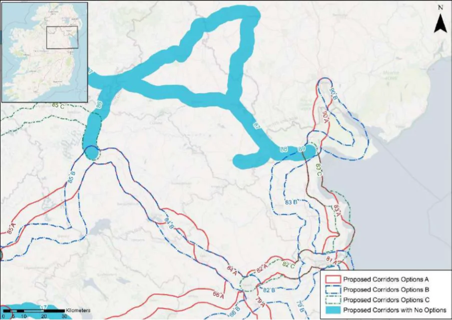
Table 83. Appraisal Relating to Corridor 83 Dundalk to Drogheda
Figure B24: Map of corridor options 83, 84 and 85
| A | Option B | C |
|---|---|---|
| 2 | 1 | 3 |
Summary of the Potential Effects Associated with Corridor 83 Dundalk to SEA Theme Drogheda
Option A: A number of designated sites occur within the corridor, including four SACs, Biodiversity two SPA and five pNHA/NHAs. These include the Boyne Estuary SPA, Boyne Coast and Estuary SAC and pNHA, River Boyne and River Blackwater SAC, Clogher Head SAC and pNHA, and Dundalk Bay SAC, SPA and pNHA. The designated sites and the key sensitivities associated with the designations would need to be considered further when determining the final route during scheme development. Land take requirements are not known at this stage; however, Option A would potentially traverse along existing road infrastructure. Option B: A number of designated sites occur within the corridor, including one SAC, one SPA and four pNHA/NHAs. These include the River Boyne and River Blackwater SAC and SPA, Boyne River Islands pNHA, Ardee Cutaway Bog pNHA. The designated sites and the key sensitivities associated with the designations would need to be considered further when determining the final route during scheme development. Land take requirements are not known at this stage; however, Option B would potentially traverses along existing road infrastructure. Option C: A number of designated sites occur within the corridor, including four SACs, two SPAs and five pNHA/NHAs. These include the Boyne Estuary SPA, Boyne Coast and Estuary SAC and pNHA, River Boyne and River Blackwater SAC, and Dundalk Bay SAC, SPA and pNHA. The designated sites and the key sensitivities associated with the designation would need to be considered further when determining the final route during scheme development. Land take requirements are not known at this stage; however, Option C would potentially traverses along existing road infrastructure and through areas of greenfield.
Appendix B: Corridor option assessment tables
National Cycle Network SEA Environmental Report (Updated)
Option
Summary of the Potential Effects Associated with Corridor 83 Dundalk to SEA Theme A B C Drogheda
| Population The corridor options would link Dundalk (population c.39,000) with Drogheda and Human (population c.40,950). Option A and C would link Castlebellingham-Kilsaran (population Health c.1,126), Clogherhead (population c.2,145) and Termonfeckin (population c.1,580), whilst Option B would link the two towns with Ardee (population c.4,928), Dunleer (population c.1,820) and Tullyallen (1,550). The corridor options would support an enhancement of accessibility to services and facilities in the settlements by active travel modes, promoting social inclusion and the quality of life of residents and supporting health and wellbeing. The corridor options also have the potential to bring benefits for the visitor economy along the corridor and support community vitality. Option C, given the corridor option follows the coastline, may do more to support the visitor economy and sustainable tourism. | 2 | 3 | 1 |
|---|---|---|---|
| Land and Option A: Land use along the proposed corridor / within the area is variable and Soils includes areas of urban fabric (artificial surfaces) and industrial or commercial units (artificial surfaces) in Dundalk, Clogherhead and Drogheda and areas of pastures (agricultural areas), non-irrigated arable land (agricultural areas) as per CORINE 2018. Should the route primarily involve the reallocation of road, loss of land and loss of productive agricultural land is unlikely to be significant. Option B: Land use along the proposed corridor / within the area is variable and includes areas of urban fabric (artificial surfaces) and industrial or commercial units (artificial surfaces) in Dundalk, Louth, Ardee, Dunleer and Drogheda and areas of pastures (agricultural areas) and non-irrigated arable land (agricultural areas) and mixed forest (forest and semi-natural areas) as per CORINE 2018. Should the route primarily involve the reallocation of road, loss of land and loss of productive agricultural land is unlikely to be significant. Option C: Land use along the proposed corridor / within the area is variable and includes areas of urban fabric (artificial surfaces) and industrial or commercial units (artificial surfaces) in Dundalk, Clogherhead and Drogheda and areas of pastures (agricultural areas), sport and leisure facilities (artificial surfaces), mixed forest (forest and semi-natural areas) as per CORINE 2018. Should the route primarily involve the reallocation of road, loss of land and loss of productive agricultural land is unlikely to be significant. | = | = | = |
| Water Option A: Several watercourses occur along the route of the proposed corridor, including the Ramparts River, River Fane, River Glyde, River Slieveboy, Termonfeckin Stream and the Boyne Estuary. The WFD status of these watercourses ranges between ‘good’ and ‘poor’ during the 2013-2018 monitoring period. The watercourses within the proposed corridor ranges from ‘at risk’ to ‘under review’. Option B: Several watercourses occur along the route of the proposed corridor, including the Ramparts River, River Fane, River Glyde, River Dee, River White, River Boyne and the Boyne Estuary. The WFD status of these watercourses ranges between ‘good’ and ‘poor’ during the 2013-2018 monitoring period. The watercourses within the proposed corridor ranges from ‘at risk’ to ‘under review’. Option C: Several watercourses occur along the route of the proposed corridor, including the Ramparts River, River Fane, River Glyde, River Slieveboy, Termonfeckin Stream, River Tullyskar and the Boyne Estuary. The WFD status of these watercourses ranges between ‘good’ and ‘poor’ during the 2013-2018 monitoring period. The watercourses within the proposed corridor ranges from ‘at risk’ to ‘under review’. | = | = | = |
| Air Quality Options A & B & C: The route occurs in an area considered to be of ‘Good’ air quality. The route will provide a safe cycle route between Dundalk and Drogheda. This will promote a modal shift to active modes of travel which will in turn support ongoing improvements to air quality in the area. | = | = | = |
| Climate The development of the corridor options as part of the NCN would promote a shift to Change active modes of travel from higher emission modes, including the private car. This will support a limitation of greenhouse gas emissions from transport. The corridor options may cross (and potentially negatively/positively impact on) areas of flood risk. Whilst impacts on flood risk, and, more broadly, climate change adaptation, depends on the detailed route of the corridor and scheme design, there would be a need to ensure that the delivery of the corridor options supports the resilience of the local area to the potential effects of climate change. | = | = | = |
Appendix B: Corridor option assessment tables AECOM
National Cycle Network SEA Environmental Report (Updated)
| A | Option B | C |
|---|---|---|
| = | = | = |
| = | = | = |
Summary of the Potential Effects Associated with Corridor 83 Dundalk to SEA Theme Drogheda
Option A: A range of cultural heritage assets are present within the proposed corridor, such as ahouse (Reg. No. 13826016) and a mound (LH019-011----). The development of the cycle corridor offers the potential for the rejuvenation and enhanced enjoyment of cultural heritage assets. However, the proposed corridor also has the potential to impact on the setting of archaeological assets which occur along the proposed corridor. Option B: A range of cultural heritage assets are present within the proposed corridor, such as aroad / track (LH017-013-----) and ritual site (LH021-003002-). The development of the cycle corridor offers the potential for the rejuvenation and enhanced enjoyment of cultural heritage assets. However, the proposed corridor also has the potential to impact on the setting of archaeological assets which occur along the proposed corridor. Option C: A range of cultural heritage assets are present within the proposed corridor, such as achurch (LH019-006001-) and a field system LH019-038----). The development of the cycle corridor offers the potential for the rejuvenation and enhanced enjoyment of cultural heritage assets. However, the proposed corridor also has the potential to impact on the setting of archaeological assets which occur along the proposed corridor.
The corridor options, given they largely follow existing transport corridors, are unlikely Landscape to lead to significant impacts on landscape character. They also offer opportunities to enhance the quality of the public realm, if high quality design and layouts are integrated within subsequent schemes. More broadly, the corridor options will support active travel modes, which are modes of transport with limited impacts on landscape character. Through promoting active travel modes, the corridor options will also support an enhanced understanding and enjoyment of the special qualities and intrinsic character of the landscape.
Appendix B: Corridor option assessment tables AECOM
National Cycle Network
Table 84. Appraisal Relating to Corridor 84 Cavan to Navan
SEA Theme Summary of the Potential Effects Associated with Corridor 84 Cavan to Navan
| Biodiversity Option A & B: Option A and B are similar, with a slight diversion between Virginia and Kells. The Lough Ramor pNHA, River Boyne and River Blackwater SAC and SPA and Killyconny Bog (Cloghbally) SAC and pNHA are located within both corridors. The designated sites and the key sensitivities associated with the designations would need to be considered further when determining the final route during scheme development. Land take requirements are not known at this stage; however, both options would potentially traverses along existing road infrastructure. | = | = |
|---|---|---|
| Population The corridor options would link Cavan (population c.10,910) with Navan (population c.30,170) and Human via Virginia (population c.2,650) and Kells (population c.6,130). Option A would also link Health Mullagh (population c.1,348). The corridor options would support an enhancement of accessibility to services and facilities in the settlements by active travel modes, promoting social inclusion and the quality of life of residents and supporting health and wellbeing. The corridor options also have the potential to bring benefits for the visitor economy along the corridor and support community vitality. Given Option A links an additional settlement (Mullagh), the option performs more favourably in relation to this SEA theme. | 1 | 2 |
| Land and Soils Option A: Land use along the proposed corridor / within the area is variable and includes areas of urban fabric (artificial surfaces) and industrial or commercial units (artificial surfaces) in Cavan, Virgina, Mullagh, Kells and Navan and areas of pastures (agricultural areas), non- irrigated arable land (agricultural areas) and mixed forest (forest and semi-natural areas) as per CORINE 2018. Should the route primarily involve the reallocation of road, loss of land and loss of productive agricultural land is unlikely to be significant. Option B: Land use along the proposed corridor / within the area is variable and includes areas of urban fabric (artificial surfaces) and industrial or commercial units (artificial surfaces) in Cavan, Virgina, Kells and Navan and areas of pastures (agricultural areas), non-irrigated arable land (agricultural areas) and mixed forest (forest and semi-natural areas) as per CORINE 2018. Should the route primarily involve the reallocation of road, loss of land and loss of productive agricultural land is unlikely to be significant. | = | = |
| Water Option A: Several watercourses occur along the route of the proposed corridor, including the Cavan River, River Stradone, Nadreegeel Lough Stream, River Blackwater, Mullagh Lough Stream and the River Boyne. The WFD status of these watercourses ranges between ‘good’ and ‘poor’ during the 2013-2018 monitoring period. The watercourses within the proposed corridor ranges from ‘at risk’ to ‘under review’. Option B: Several watercourses occur along the route of the proposed corridor, including the Cavan River, River Stradone, Nadreegeel Lough Stream, River Blackwater, Mullagh Lough Stream and the River Boyne. The WFD status of these watercourses ranges between ‘good’ and ‘poor’ during the 2013-2018 monitoring period. The watercourses within the proposed corridor ranges from ‘at risk’ to ‘under review’. | = | = |
| Air Quality Options A & B: The route occurs in an area considered to be of ‘Good’ air quality. The route will provide a safe cycle route between Cavan and Navan. This will promote a modal shift to active modes of travel which will in turn support ongoing improvements to air quality in the area. | = | = |
| Climate The development of the corridor options as part of the NCN would promote a shift to active Change modes of travel from higher emission modes, including the private car. This will support a limitation of greenhouse gas emissions from transport. Option A, given it links an additional settlement (Mullagh), will however bring additional benefits in relation to this element of climate change mitigation. The corridor options may cross (and potentially negatively/positively impact on) areas of flood risk. Whilst impacts on flood risk, and, more broadly, climate change adaptation, depends on the detailed route of the corridor and scheme design, there would be a need to ensure that the delivery of the corridor options supports the resilience of the local area to the potential effects of climate change. | 1 | 2 |
| Cultural Option A: A range of cultural heritage assets are present within the proposed corridor, such Heritage as a ring ditch (ME017-065001-) and a ringfort (CV039-078----). The development of the cycle corridor offers the potential for the rejuvenation and enhanced enjoyment of cultural heritage assets. However, the proposed corridor also has the potential to impact on the setting of archaeological assets which occur along the proposed corridor. Option B: A range of cultural heritage assets are present within the proposed corridor, such as a ring ditch (ME017-065001-) and a ringfort (CV039-078----). The development of the cycle corridor offers the potential for the rejuvenation and enhanced enjoyment of cultural heritage assets. However, the proposed corridor also has the potential to impact on the setting of archaeological assets which occur along the proposed corridor. | = | = |
Appendix B: Corridor option assessment tables
National Cycle Network SEA Environmental Report (Updated)
| Option A | B |
|---|---|
| = | = |
SEA Theme Summary of the Potential Effects Associated with Corridor 84 Cavan to Navan
The corridor options, given they largely follow existing transport corridors, are unlikely to lead Landscape to significant impacts on landscape character. They also offer opportunities to enhance the quality of the public realm, if high quality design and layouts are integrated within subsequent schemes. More broadly, the corridor options will support active travel modes, which are modes of transport with limited impacts on landscape character. Through promoting active travel modes, the corridor options will also support an enhanced understanding and enjoyment of the special qualities and intrinsic character of the landscape.
Appendix B: Corridor option assessment tables AECOM
National Cycle Network
Table 85. Appraisal Relating to Corridor 85 Longford to Cavan
SEA Theme Summary of the Potential Effects Associated with Corridor 85 Longford to Cavan
| Biodiversity Option A: A number of designated sites occur within the corridor, including one SAC, no SPAs and five pNHA/NHAs. These include the Lough Oughter and Associated Loughs SAC and pNHA, Drumkeen House Woodland pNHA, Cordonaghy Bog pNHA, Carrickglass Demesne pNHA and Lough Gowna pNHA. Option B: A number of designated sites occur within the corridor, including three SACs, two SPAs and seven pNHA/NHA. These include Lough Oughter and Associated Loughs SAC and pNHA, Drumkeen House Woodland pNHA, Cordonaghy Bog pNHA, Carrickglass Demesne pNHA, Lough Gowna pNHA, Lough Sheelin SPA and pNHA, Moneybeg and Clareisland Bogs SAC and Derragh Bog SAC. Option C: A number of designated sites occur within the corridor, including two SACs, one SPA and fifteen pNHA/NHAs. These include the Lough Oughter and Associated Loughs SAC and pNHA, Ballykenny-Fisherstown Bog SPA, Lough Forbes Complex SAC and pNHA, Rinn River NHA, Lough Errew pNHA, and Corduff Lough pNHA. Option A, B &C: The designated sites and the key sensitivities associated with the designations would need to be considered further when determining the final route during scheme development. Land take requirements are not known at this stage; however, all options would potentially traverse sections of greenfield as well as traverse along existing infrastructure. | = | = | = |
|---|---|---|---|
| Population and The corridor options would link Longford (population c.10,010) with Cavan (population Human Health c.10,910). Option C, which is the northerly corridor option, would also link Ballyconnell (population c.1,100) and Belturbet (population c.1,370). The corridor options would support an enhancement of accessibility to services and facilities in the settlements by active travel modes, promoting social inclusion and the quality of life of residents and supporting health and wellbeing. The corridor options also have the potential to bring benefits for the visitor economy along the corridor and support community vitality. Given Option C links additional settlements, this option performs the most favourably of the three options in relation to this SEA theme. | = | = | 1 |
| Land and Soils Option A: Land use along the proposed corridor / within the area is variable and includes areas of urban fabric (artificial surfaces) in Cavan and Longford town and areas of pastures (agricultural areas), non-irrigated arable land (agricultural areas), peat bogs (wetland) and inland marshes (wetland) as per CORINE 2018. Should the route primarily involve the reallocation of road / historic railway line, loss of land and loss of productive agricultural land is unlikely to be significant. Option B: Land use along the proposed corridor / within the area is variable and includes areas of urban fabric (artificial surfaces) in Cavan, Granard and Longford town and areas of pastures (agricultural areas), non-irrigated arable land (agricultural areas), peat bogs (wetland) and inland marshes (wetland) as per CORINE 2018. Should the route primarily involve the reallocation of road / historic railway line, loss of land and loss of productive agricultural land is unlikely to be significant. Option C: Land use along the proposed corridor / within the area is variable and includes areas of urban fabric (artificial surfaces) in Cavan, Staghall, Mohill and Longford town and areas of pastures (agricultural areas), non-irrigated arable land (agricultural areas), peat bogs (wetland) and coniferous forests (forest and semi-natural areas) as per CORINE 2018. Should the route primarily involve the reallocation of road / historic railway line, loss of land and loss of productive agricultural land is unlikely to be significant. | = | = | = |
| Water Option A: Several watercourses occur along the route of the proposed corridor, including the Cavan River, River Erne, River Camlin. The WFD status of these watercourses ranges between ‘good’ and ‘poor’ during the 2013-2018 monitoring period. The watercourses within the proposed corridor ranges from ‘at risk’ to ‘under review’. Option B: Several watercourses occur along the route of the proposed corridor, including the Cavan River, River Erne, River Inny and the River Camlin. The WFD status of these watercourses ranges between ‘good’ and ‘poor’ during the 2013-2018 monitoring period. The watercourses within the proposed corridor ranges from ‘at risk’ to ‘under review’. Option C: Several watercourses occur along the route of the proposed corridor, including the Cavan River, River Erne, River Woodford, River Blackwater, River Cloone, River Rinn and the River Shannon. The WFD status of these watercourses ranges between ‘good’ and ‘poor’ during the 2013-2018 monitoring period. The watercourses within the proposed corridor ranges from ‘at risk’ to ‘under review’. | = | = | = |
| Air Quality Options A & B & C: The route occurs in an area considered to be of ‘Good’ air quality. The route will provide a safe cycle route between Cavan and Longford town. This will promote a modal shift to active modes of travel which will in turn support ongoing improvements to air quality in the area. | = | = | = |
Appendix B: Corridor option assessment tables
National Cycle Network SEA Environmental Report (Updated)
Option
SEA Theme Summary of the Potential Effects Associated with Corridor 85 Longford to Cavan A B C
| Climate Change The development of the corridor options as part of the NCN would promote a shift to active modes of travel from higher emission modes, including the private car. This will support a limitation of greenhouse gas emissions from transport. Option C, given it links additional settlements, will however bring additional benefits in relation to this element of climate change mitigation. The corridor options may cross (and potentially negatively/positively impact on) areas of flood risk. Whilst impacts on flood risk, and, more broadly, climate change adaptation, depends on the detailed route of the corridor and scheme design, there would be a need to ensure that the delivery of the corridor options supports the resilience of the local area to the potential effects of climate change. | = | = | 1 |
|---|---|---|---|
| Cultural Heritage Option A: A range of cultural heritage assets are present within the proposed corridor, such as a crannog (CV025-017----) and a ringfort (CV031-037---). Given part of the proposed corridor is located along a railway line, sensitive development of the corridor as a cycle route offers the potential for the rejuvenation and enhanced enjoyment of this heritage asset. However, the proposed corridor also has the potential to impact on the setting of other cultural heritage assets (e.g., archaeological remains) which may occur along the proposed corridor. Option B: A range of cultural heritage assets are present within the proposed corridor, such as a crannog (CV025-017----), ford (CV041-023----) and a barrow (LF011-015---- ). Given part of the proposed corridor is located along a railway line, sensitive development of the corridor as a cycle route offers the potential for the rejuvenation and enhanced enjoyment of this heritage asset. However, the proposed corridor also has the potential to impact on the setting of other cultural heritage assets (e.g., archaeological remains) which may occur along the proposed corridor. Option C: A range of cultural heritage assets are present within the proposed corridor, such as a ritual site (LE032-066----) and a cottage ornee (Reg. No. 30932001) Given part of the proposed corridor is located along a railway line, sensitive development of the corridor as a cycle route offers the potential for the rejuvenation and enhanced enjoyment of this heritage asset. However, the proposed corridor also has the potential to impact on the setting of other cultural heritage assets (e.g., archaeological remains) which may occur along the proposed corridor. Options B & C are likely to perform more favourably in relation to this SEA theme, as they align more along existing infrastructure (railway) and would rejuvenation and connect cultural heritage assets along this route. | 2 | = | = |
| Landscape The corridor options, given they largely follow existing transport corridors, are unlikely to lead to significant impacts on landscape character. They also offer opportunities to enhance the quality of the public realm, if high quality design and layouts are integrated within subsequent schemes. More broadly, the corridor options will support active travel modes, which are modes of transport with limited impacts on landscape character. Through promoting active travel modes, the corridor options will also support an enhanced understanding and enjoyment of the special qualities and intrinsic character of the landscape. | = | = | = |
Appendix B: Corridor option assessment tables AECOM
National Cycle Network
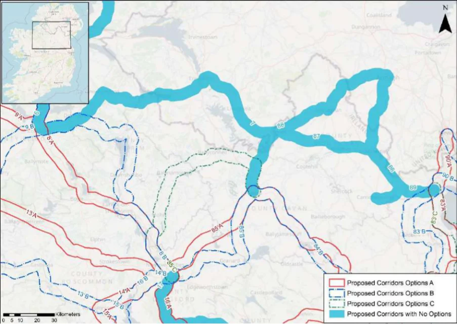
Table 86. Appraisal Relating to Corridor 86 Armagh to Cavan
Figure B25: Map of corridor option 86
SEA Theme Summary of the Potential Effects Associated with Corridor 86 Armagh to Cavan
A number of designated sites occur within the corridor, including two SACs, no SPAs and Biodiversity eleven pNHA/NHAs. These include Lough Oughter and Associated Loughs SAC and pNHA, Annagheane Lough pNHA, Kilroosky Lough Cluster SAC and pNHA, Lislannan Bog pNHA, Rosefield Lake and Woodland pNHA, and Wright’s Wood pNHA. The Caledon and Tynan ASSI (Area of Special Scientific Interest) is also located within the corridor. The designated sites and the key sensitivities associated with the designation would need to be considered further when determining the final route during scheme development. Land take requirements are not known at this stage; however, the corridor follows a historic railway line route and would traverse areas of greenfield.
Population and Human Health
The corridor will link Armagh in Northern Ireland (population c.14,780) and Cavan (population c.10,914) via Monaghan (population c.7,680) and Clones (c1,680). The corridor would support an enhancement of accessibility to services and facilities in the settlements by active travel modes, promoting social inclusion and the quality of life of residents and supporting health and wellbeing. The corridor also has the potential to bring benefits for the visitor economy along the corridor and support community vitality.
Land use along the proposed corridor / within the area is variable and includes areas of Land and Soils urban fabric (artificial surfaces) in Cavan, Clones, Monaghan and Armagh and areas of pastures (agricultural areas) and non-irrigated arable land (agricultural areas) as per CORINE 2018. Should the route primarily involve the reallocation of road / historic railway line, loss of land and loss of productive agricultural land is unlikely to be significant. Should the route require some land-take (from agriculture), the impact to likely to be significant / uncertain.
Several watercourses occur along the route of the proposed corridor, including the Cavan Water River, River Finn, River Maghery, River Blackwater, River Cor and the Callan River. The WFD status of these watercourses ranges between ‘good’ and ‘poor’ during the 2013-2018 monitoring period. The watercourses within the proposed corridor ranges from ‘at risk’ to ‘under review’.
The route occurs in an area considered to be of ‘Good’ air quality. The route will provide a Air Quality safe cycle route between Cavan and Armagh. This will promote a modal shift to active modes of travel which will in turn support ongoing improvements to air quality in the area.
Appendix B: Corridor option assessment tables
National Cycle Network SEA Environmental Report (Updated)
SEA Theme Summary of the Potential Effects Associated with Corridor 86 Armagh to Cavan Impact
The development of the corridor as part of the NCN would promote a shift to active modes Climate Change of travel from higher emission modes, including the private car. This will support a limitation of greenhouse gas emissions from transport. The corridor may cross (and potentially negatively/positively impact on) areas of flood risk. Whilst impacts on flood risk, and, more broadly, climate change adaptation, depends on the detailed route of the corridor and scheme design, there would be a need to ensure that the delivery of the corridor supports the resilience of the local area to the potential effects of climate change.
Positive
Cultural Heritage A range of cultural heritage assets are present within the proposed corridor, such as a
ringfort (CV015-034----) and a bridge (Reg. No. 414016250). Given part of the proposed corridor is located along a railway line, sensitive development of the corridor as a cycle route offers the potential for the rejuvenation and enhanced enjoyment of this heritage asset. However, the proposed corridor also has the potential to impact on the setting of other cultural heritage assets (e.g., archaeological remains) which may occur along the proposed corridor.
Uncertain
The proposed corridor, given it is likely to follow existing transport infrastructure, is unlikely Landscape to lead to significant impacts on landscape character. It also offers opportunities to enhance the quality of the public realm, if high quality design and layouts are integrated within subsequent schemes. More broadly, the implementation of the corridor will support active travel modes, which are modes of transport with limited impacts on landscape character. Through promoting active travel modes, the corridor also offers opportunities to support an enhanced understanding and enjoyment of the special qualities and intrinsic character of the landscape in the vicinity of the corridor.
Positive
Appendix B: Corridor option assessment tables AECOM
National Cycle Network
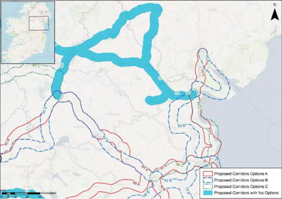
Table 87. Appraisal Relating to Corridor 87 Dundalk to Monaghan
Figure B26: Map of corridor options 87, 88, 89 and 90
Summary of the Potential Effects Associated with Corridor 87 Dundalk to SEA Theme Monaghan
A number of designated sites occur within the corridor, including one SAC, no SPAs and Biodiversity twelve pNHA/NHAs. These include the Drumcah, Toprass and Cortial Loughs pNHA, Lough Ross pNHA, Kilroosky Lough Cluster SAC and pNHA, Lislannan Bog pNHA, Wright’s Wood pNHA, and Drumreaske Lough pNHA. The designated sites and the key sensitivities associated with the designations would need to be considered further when determining the final route during scheme development. Land take requirements are not known at this stage; however, the corridor follows a historic railway line route and would traverse areas of greenfield.
Population and Human Health
The corridor will link Dundalk (population c.39,000) with Monaghan (population c.7,680) via Clones (c.1,680), Ballybay (population c.1,241) and Castleblayney (population c.3,600). The corridor would support an enhancement of accessibility to services and facilities in the settlements by active travel modes, promoting social inclusion and the quality of life of residents and supporting health and wellbeing. The corridor also has the potential to bring benefits for the visitor economy along the corridor and support community vitality.
Land use along the proposed corridor / within the area is variable and includes areas of Land and Soils urban fabric (artificial surfaces) in Dundalk, Castleblayney, Clones and Monaghan and areas of pastures (agricultural areas) and non-irrigated arable land (agricultural areas) as per CORINE 2018. Should the route primarily involve the reallocation of road / historic railway line, loss of land and loss of productive agricultural land is unlikely to be significant.
Several watercourses occur along the route of the proposed corridor, including the Water Ramparts River, River Fane, Major Lough Stream, Dromore River, River Finn, Magherarney River, River Blackwater. The WFD status of these watercourses ranges between ‘good’ and ‘poor’ during the 2013-2018 monitoring period. The watercourses within the proposed corridor ranges from ‘at risk’ to ‘under review’.
The route occurs in an area considered to be of ‘Good’ air quality. The route will provide a Air Quality safe cycle route between Dundalk and Monaghan. This will promote a modal shift to active modes of travel which will in turn support ongoing improvements to air quality in the area.
The development of the corridor as part of the NCN would promote a shift to active modes Climate Change of travel from higher emission modes, including the private car. This will support a limitation of greenhouse gas emissions from transport.
Appendix B: Corridor option assessment tables
National Cycle Network SEA Environmental Report (Updated)
Summary of the Potential Effects Associated with Corridor 87 Dundalk to SEA Theme Monaghan
Impact
The corridor may cross (and potentially negatively/positively impact on) areas of flood risk. Whilst impacts on flood risk, and, more broadly, climate change adaptation, depends on the detailed route of the corridor and scheme design, there would be a need to ensure that the delivery of the corridor supports the resilience of the local area to the potential effects of climate change.
Cultural Heritage A range of cultural heritage assets are present within the proposed corridor, such as a
sweathouse (LH006-112----) and a bridge (Reg. No. 41402903). Given part of the proposed corridor is located along a railway line, sensitive development of the corridor as a cycle route offers the potential for the rejuvenation and enhanced enjoyment of this heritage asset. However, the proposed corridor also has the potential to impact on the setting of other cultural heritage assets (e.g., archaeological remains) which may occur along the proposed corridor.
Uncertain
The proposed corridor, given it is likely to follow existing transport infrastructure, is unlikely Landscape to lead to significant impacts on landscape character. It also offers opportunities to enhance the quality of the public realm, if high quality design and layouts are integrated within subsequent schemes. More broadly, the implementation of the corridor will support active travel modes, which are modes of transport with limited impacts on landscape character. Through promoting active travel modes, the corridor also offers opportunities to support an enhanced understanding and enjoyment of the special qualities and intrinsic character of the landscape in the vicinity of the corridor.
Positive
Appendix B: Corridor option assessment tables AECOM
National Cycle Network
Table 88. Appraisal Relating to Corridor 88 Dundalk to Armagh
SEA Theme Summary of the Potential Effects Associated with Corridor 88 Dundalk to Armagh
| Biodiversity Drumcah, Toprass and Cortial Loughs pNHA, Lough Ross pNHA, Muckno Lake pNHA, Lough Smiley pNHA, Drumarg ASSI (Area of Special Scientific Interest) and Straghans Lough ASSI are located within the corridor. The designated sites and the key sensitivities associated with the designations would need to be considered further when determining the final route during scheme development. Land take requirements are not known at this stage; however the corridor follows a historic railway line route and would traverse areas of greenfield. | Uncertain |
|---|---|
| Population and The corridor will link Dundalk (population c.39,000) with Armagh in Northern Ireland Human Health (population c.14,780) via Castleblayney (population c.3,600) and Keady (in Northern Ireland, population c.3,050). The corridor would support an enhancement of accessibility to services and facilities in the settlements by active travel modes, promoting social inclusion and the quality of life of residents and supporting health and wellbeing. The corridor also has the potential to bring benefits for the visitor economy along the corridor and support community vitality. | Positive |
| Land and Soils Land use along the proposed corridor / within the area is variable and includes areas of urban fabric (artificial surfaces) in Dundalk, Castleblayney and Armagh and areas of pastures (agricultural areas) and non-irrigated arable land (agricultural areas) as per CORINE 2018 Should the route primarily involve the reallocation of road / historic railway line, loss of land and loss of productive agricultural land is unlikely to be significant. | Uncertain |
| Water Several watercourses occur along the route of the proposed corridor, including the Ramparts River, River Fane, Gentle Owen’s Lake Stream, Ballymacane River and Callan River. The WFD status of these watercourses ranges between ‘good’ and ‘poor’ during the 2013-2018 monitoring period. The watercourses within the proposed corridor range from ‘at risk’ to ‘under review’. | Uncertain |
| Air Quality The route occurs in an area considered to be of ‘Good’ air quality. The route will provide a safe cycle route between Dundalk and Armagh. This will promote a modal shift to active modes of travel which will in turn support ongoing improvements to air quality in the area. | Positive |
| Climate Change The development of the corridor as part of the NCN would promote a shift to active modes of travel from higher emission modes, including the private car. This will support a limitation of greenhouse gas emissions from transport. The corridor may cross (and potentially negatively/positively impact on) areas of flood risk. Whilst impacts on flood risk, and, more broadly, climate change adaptation, depends on the detailed route of the corridor and scheme design, there would be a need to ensure that the delivery of the corridor supports the resilience of the local area to the potential effects of climate change. | Positive |
| Cultural Heritage A range of cultural heritage assets are present within the proposed corridor, such as a ringfort (MO028-022----) and an enclosure (MO028-023----). Given part of the proposed corridor is located along a railway line, sensitive development of the corridor as a cycle route offers the potential for the rejuvenation and enhanced enjoyment of this heritage asset. However, the proposed corridor also has the potential to impact on the setting of other cultural heritage assets (e.g., archaeological remains) which may occur along the proposed corridor. | Uncertain |
| Landscape The proposed corridor, given it is likely to follow existing transport infrastructure, is unlikely to lead to significant impacts on landscape character. It also offers opportunities to enhance the quality of the public realm, if high quality design and layouts are integrated within subsequent schemes. More broadly, the implementation of the corridor will support active travel modes, which are modes of transport with limited impacts on landscape character. Through promoting active travel modes, the corridor also offers opportunities to support an enhanced understanding and enjoyment of the special qualities and intrinsic character of the landscape in the vicinity of the corridor. | Positive |
Appendix B: Corridor option assessment tables
National Cycle Network
Table 89. Appraisal Relating to Corridor 89 Dundalk to Carrickmacross
Summary of the Potential Effects Associated with Corridor 89 Dundalk to SEA Theme Carrickmacross
| Biodiversity Drumcah, Toprass and Cortial Loughs pNHA, Monalty Lough pNHA, Spring and Corcrin Loughs pNHA, Lough Naglack pNHA, Lough Fea Demesne pNHA, and Nafarty Fen pNHA are located within the corridor. The designated sites and the key sensitivities associated with the designations would need to be considered further when determining the final route during scheme development. Land take requirements are not known at this stage; however a section of the corridor follows a historic railway line route and would traverse areas of greenfield. | Uncertain |
|---|---|
| Population and The corridor will link Dundalk (population c.39,000) with Carrickmacross (population Human Health c.5,030). The corridor would support an enhancement of accessibility to services and facilities in the settlements by active travel modes, promoting social inclusion and the quality of life of residents and supporting health and wellbeing. The corridor also has the potential to bring benefits for the visitor economy along the corridor and support community vitality. | Positive |
| Land and Soils Land use along the proposed corridor / within the area is variable and includes areas of urban fabric (artificial surfaces) in Carrickmacross and Dundalk and areas of pastures (agricultural areas), non-irrigated arable land (agricultural areas) and peat bogs (wetland) as per CORINE 2018. Should the route primarily involve the reallocation of road / historic railway line, loss of land and loss of productive agricultural land is unlikely to be significant. | Uncertain |
| Water Several watercourses occur along the route of the proposed corridor, including the River Proules, River Fane, River Carrickrobin and the Ramparts River. The WFD status of these watercourses ranges between ‘good’ and ‘poor’ during the 2013-2018 monitoring period. The watercourses within the proposed corridor range from ‘at risk’ to ‘under review’. | Uncertain |
| Air Quality The route occurs in an area considered to be of ‘Good’ air quality. The route will provide a safe cycle route between Carrickmacross and Dundalk. This will promote a modal shift to active modes of travel which will in turn support ongoing improvements to air quality in the area. | Positive |
| Climate Change The development of the corridor as part of the NCN would promote a shift to active modes of travel from higher emission modes, including the private car. This will support a limitation of greenhouse gas emissions from transport. The corridor may cross (and potentially negatively/positively impact on) areas of flood risk. Whilst impacts on flood risk, and, more broadly, climate change adaptation, depends on the detailed route of the corridor and scheme design, there would be a need to ensure that the delivery of the corridor supports the resilience of the local area to the potential effects of climate change. | Positive |
| Cultural Heritage A range of cultural heritage assets are present within the proposed corridor, such as an enclosure (MO029-027----) and a bridge (Reg. No. 41403117). Given part of the proposed corridor is located along a historic railway line, sensitive development of the corridor as a cycle route offers the potential for the rejuvenation and enhanced enjoyment of this heritage asset. However, the proposed corridor also has the potential to impact on the setting of other cultural heritage assets (e.g., archaeological remains) which may occur along the proposed corridor. | Uncertain |
| Landscape The proposed corridor, given it is likely to follow existing transport infrastructure, is unlikely to lead to significant impacts on landscape character. It also offers opportunities to enhance the quality of the public realm, if high quality design and layouts are integrated within subsequent schemes. More broadly, the implementation of the corridor will support active travel modes, which are modes of transport with limited impacts on landscape character. Through promoting active travel modes, the corridor also offers opportunities to support an enhanced understanding and enjoyment of the special qualities and intrinsic character of the landscape in the vicinity of the corridor. | Positive |
Appendix B: Corridor option assessment tables
National Cycle Network
Table 90. Appraisal Relating to Corridor 90 Newry to Dundalk
SEA Theme Summary of the Potential Effects Associated with Corridor 90 Newry to Dundalk
| Biodiversity Option A: A number of designated sites occur within the corridor, including two SACs, one SPA, three pNHA/NHAs and four ASSIs (Area of Special Scientific Interest). These include the Dundalk Bay SAC, SPA and pNHA, Carlingford Mountain SAC and pNHA, Carlingford Lough ASSI, Ring of Gullion ASSI and Ravensdale Plantation pNHA. The designated sites and the key sensitivities associated with the designations would need to be considered further when determining the final route during scheme development. Land take requirements are not known at this stage; however it is anticipated the route would utilise existing infrastructure where practicable such as road infrastructure. Option B: A number of designated sites occur within the corridor, including three SACs, two SPAs, six pNHA/NHAs and five ASSI. These include Dundalk Bay SAC, SPA and pNHA, Carlingford Mountain SAC and pNHA, Liscarragh Marsh pNHA, Carlingford Lough SAC, SPA and pNHA, Carlingford Lough ASSI and Ring of Gullion ASSI. The designated sites and the key sensitivities associated with the designations would need to be considered further when determining the final route during scheme development. Land take requirements are not known at this stage; however, it is anticipated the route would utilise existing infrastructure where practicable such as road infrastructure. A section of the corridor follows a historic railway line route and could potentially traverse areas of greenfield. | 1 | 2 |
|---|---|---|
| Population and The corridor options would link Newry in Northern Ireland (population c.13,210) with Dundalk Human Health (population c.39,000). Option B would also link Carlingford (population c.1,445). The corridor options would support an enhancement of accessibility to services and facilities in the settlements by active travel modes, promoting social inclusion and the quality of life of residents and supporting health and wellbeing. The corridor options also have the potential to bring benefits for the visitor economy along the corridor and support community vitality. Given Option B links more communities, the option is likely to perform better than Option A in relation to this SEA theme. Option B also offers additional potential to make more of the visitor offer of the Cooley Peninsula and support sustainable tourism. | 2 | 1 |
| Land and Soils Option A: Land use along the proposed corridor / within the area is variable and includes areas of urban fabric (artificial surfaces) in Dundalk, Dromad and Newry and areas of pastures (agricultural areas), non-irrigated arable land (agricultural areas) and coniferous forests (forest and semi-natural areas) as per CORINE 2018. Should the route primarily involve the reallocation of road, loss of land and loss of productive agricultural land is unlikely to be significant. Should the route require land-take (from agriculture), the impact to likely to be significant / uncertain. Option B: Land use along the proposed corridor / within the area is variable and includes areas of urban fabric (artificial surfaces) in Dundalk and Carlingford and Newry and areas of pastures (agricultural areas), non-irrigated arable land (agricultural areas) and coniferous forests (forest and semi-natural areas) as per CORINE 2018. Should the route primarily involve the reallocation of road / historic railway line, loss of land and loss of productive agricultural land is unlikely to be significant. Option B is likely to perform more favourably in relation to this SEA theme as it aligns more along existing rail infrastructure and would require less land-take. | 2 | 1 |
| Water Option A: Several watercourses occur along the route of the proposed corridor, including the Castletown Estuary, River Raskeagh, River Flurry. The WFD status of these watercourse ranges between ‘good’ and ‘poor’ during the 2013-2018 monitoring period. The watercourses within the proposed corridor ranges from ‘at risk’ to ‘under review’. Option B Several watercourses occur along the route of the proposed corridor, including the Castletown Estuary, River Raskeagh, River Rockmarshall, River Big, Newry Estuary and Carlingford Lough. The WFD status of these watercourses ranges between ‘good’ and ‘poor’ during the 2013-2018 monitoring period. The watercourses within the proposed corridor range from ‘at risk’ to ‘under review’. | = | = |
| Air Quality Options A & B: The route occurs in an area considered to be of ‘Good’ air quality. The route will provide a safe cycle route between Dundalk and Newry. This will promote a modal shift to active modes of travel which will in turn support ongoing improvements to air quality in the area. | = | = |
| Climate Change The development of the corridor options as part of the NCN would promote a shift to active modes of travel from higher emission modes, including the private car. This will support a limitation of greenhouse gas emissions from transport. Option B, given it links an additional settlement (Carlingford), will however bring additional benefits in relation to this element of climate change mitigation. The corridor options may cross (and potentially negatively/positively impact on) areas of flood risk. Whilst impacts on flood risk, and, more broadly, climate change adaptation, depends on the detailed route of the corridor and scheme design, there would be a need to ensure that the delivery of the corridor options supports the resilience of the local area to the potential effects of climate change. | 2 | 1 |
Appendix B: Corridor option assessment tables
National Cycle Network SEA Environmental Report (Updated)
| Option A | B |
|---|---|
| 2 | 1 |
| = | = |
SEA Theme Summary of the Potential Effects Associated with Corridor 90 Newry to Dundalk
Option A: A range of cultural heritage assets are present within the proposed corridor, such Cultural Heritage as a metalworking site (LH007-127002-) and fulacht fia (LH007-128----). The development of the cycle corridor offers the potential for the rejuvenation and enhanced enjoyment of cultural heritage assets. However, the proposed corridor also has the potential to impact on the setting of archaeological assets which occur along the proposed corridor. Option B: A range of cultural heritage assets are present within the proposed corridor, such as a midden (LH008-034----) and a bridge (Reg. No. 13900806). Given part of the proposed corridor is located along a historic railway line, sensitive development of the corridor as a cycle route offers the potential for the rejuvenation and enhanced enjoyment of this heritage asset. However, the proposed corridor also has the potential to impact on the setting of other cultural heritage assets (e.g., archaeological remains) which may occur along the proposed corridor. Option B is the preferred option for cultural heritage, as it aligns along existing infrastructure (railway) and would rejuvenation and connect cultural heritage assets along this route.
The corridor options, given they largely follow existing transport corridors, are unlikely to lead Landscape to significant impacts on landscape character. They also offer opportunities to enhance the quality of the public realm, if high quality design and layouts are integrated within subsequent schemes. More broadly, the corridor options will support active travel modes, which are modes of transport with limited impacts on landscape character. Through promoting active travel modes, the corridor options will also support an enhanced understanding and enjoyment of the special qualities and intrinsic character of the landscape.
Appendix B: Corridor option assessment tables AECOM
AECOM Ireland Limited 4th Floor Adelphi Plaza Georges Street Upper Dun Laoghaire Co. Dublin A96 T927 Ireland
T: +353 1 238 3100 aecom.com
Appendix H
SEA Adoption Statement
National Cycle Network Plan
Figure from page 451
Strategic Environmental Assessment (SEA) Adoption Statement
Transport Infrastructure Ireland
July 2022
National Cycle Network Plan SEA Adoption Statement
Quality information
Prepared by Checked by Verified by Approved by
Rebecca Dunlea Senior Environmental Consultant
Nick Chisholm-Batten Associate Director Environment
Ben Green Associate Director Transport
Derval Cummins Director of Planning
Revision History
Revision Revision date Details Authorized Name Position
28th July 2022 28th July 2022 V1.0 (Draft) Final Nick Chisholm-Batten Associate Director
Prepared for:
Transport Infrastructure Ireland
Prepared by:
AECOM Ireland Limited 4th Floor Adelphi Plaza Georges Street Upper Dun Laoghaire Co. Dublin A96 T927 Ireland T: +353 1 238 3100 aecom.com
© 2022 AECOM Ireland Limited. All Rights Reserved.
This document has been prepared by AECOM Ireland Limited (“AECOM”) for sole use of our client (the “Client”) in accordance with generally accepted consultancy principles, the budget for fees and the terms of reference agreed between AECOM and the Client. Any information provided by third parties and referred to herein has not been checked or verified by AECOM, unless otherwise expressly stated in the document. No third party may rely upon this document without the prior and express written agreement of AECOM.
Prepared for: Transport Infrastructure Ireland AECOM
National Cycle Network Plan SEA Adoption Statement
Table of Contents
- Introduction … 1 1.1 Introduction and Legislative Context … 1 1.2 Content of the SEA Adoption Statement … 2 1.3 Implications of SEA for the Plan … 2 2. How Environmental Considerations were Integrated into the Plan … 4 2.1 Introduction … 4 2.2 Consultation … 4 2.3 Communication of Environmental Sensitivities Throughout the SEA process … 5 2.3.1 Appropriate Assessment (AA) … 5 2.4 Consideration of Alternatives … 6 2.5 Integration of Individual Measures into the NCN Plan … 6 3. Environmental Report and Submissions / Observations … 7 3.1 Introduction … 7 3.2 Submissions on the SEA Scoping Report … 7 3.3 Submissions on the Draft NCN Plan and SEA Environmental Report … 9 3.4 SEA Environmental Report … 9 4. Summary of Alternatives Considered … 20 4.1 Introduction … 20 4.2 Limitations in Available Alternatives … 20 4.3 Assessment of Reasonable Alternatives for the NCN Plan… 21 4.4 Summary of Evaluation of Alternatives … 21 5. Monitoring Measures … 22 5.1 Introduction … 22 5.2 Indicators … 22 5.3 Targets … 23 5.4 Sources, Reporting and Frequency … 23 Appendix A Summary of Scoping Submissions … 27
Pages 266–453 · View in original PDF