70 [approximately 110kph]
*Separation strip should be at least 0.5m alongside kerbside parking and 1.5m where wheelchair access is required.
Regional Design Manuals
Many regional or local authorities publish their own design standards for application on cycle infrastructure under their authority. A frequently cited and referenced manual is that produced by Transport for London (TfL), the London Cycling Design Standards (LCDS)6 published in 2019.
The LCDS details guiding principles and detailed design requirements. It does not carry a legal obligation, but ‘any decision to depart from its advice should be accompanied by a reasoned justification for doing so’ (Transport for London, 2019). It specifies six core design outcomes, similar to those of the Cycle Infrastructure Design manual: Safety, Directness, Comfort, Coherence, Attractiveness and Adaptability.
It also specifies 20 guiding principles (also like those of the Cycle Infrastructure Design manual):
1.Cycling is now mass transport and must be treated as such.
2.Facilities must be designed for larger numbers of users.
3.Cycles must be treated as vehicles, not as pedestrians.
National Cycle Network Plan - Appendices
4.Cyclists need space separated from volume motor traffic.
5.Where full segregation is not possible, semi-segregation may be the answer.
6.Separation can also be achieved by using lower-traffic streets.
7.Where integration with other road users is necessary, differences of speed, volume and vehicle type should be minimised.
8.Cyclist interventions need not be attempted on every road.
9.Routes must flow.
10.Routes must be intuitively understandable by all users.
11.Provision must be consistent and routes must be planned as a network.
12.Routes and schemes must take account of how users actually behave. If they do not, they will be ignored.
13.Many of the standard tools currently used to manage cyclists’ interactions with others do not work.
14.Changes in road space can influence modal choice.
15.Trials can help achieve change.
16.Avoid over-complication and the ‘materials trap’.
17.But do not be afraid of capital infrastructure.
18.All designers of cycle schemes must experience the roads on a cycle.
19.As important as building a route itself is maintaining it properly afterwards.
20.Know when to break these principles.
Given that the context of the report is specific to London, its focus is primarily on cycle infrastructure in an urban setting and providing guidance on assessing the Cycling Level of Service (CLoS). A CLoS assessment matrix and a junction assessment tool are provided. Detailed guidance and criteria are provided for cycle lanes and tracks, junctions and crossings, signs and markings, construction and cycle parking some of which are included here.
National Cycle Network Plan - Appendices
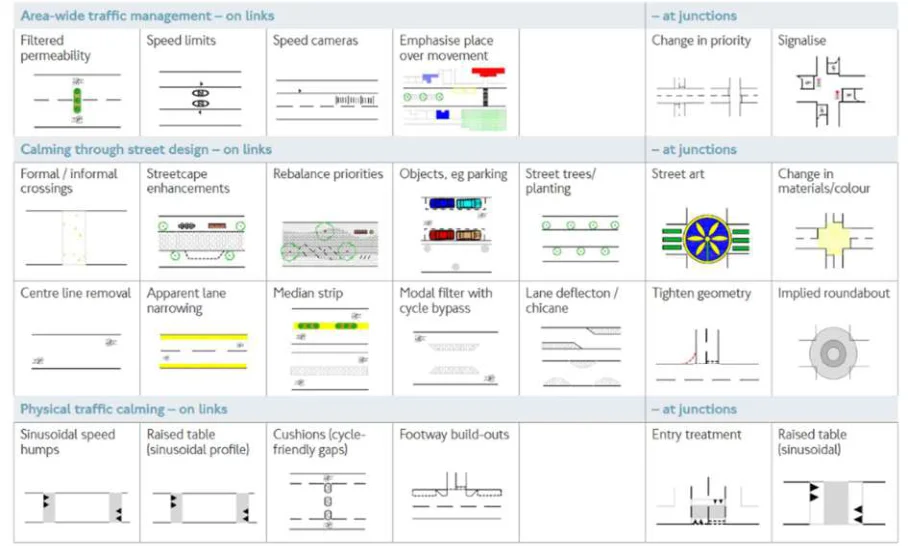
Figure from page 107
Figure B.13 : Traffic Calming Techniques (extract from LCDS)
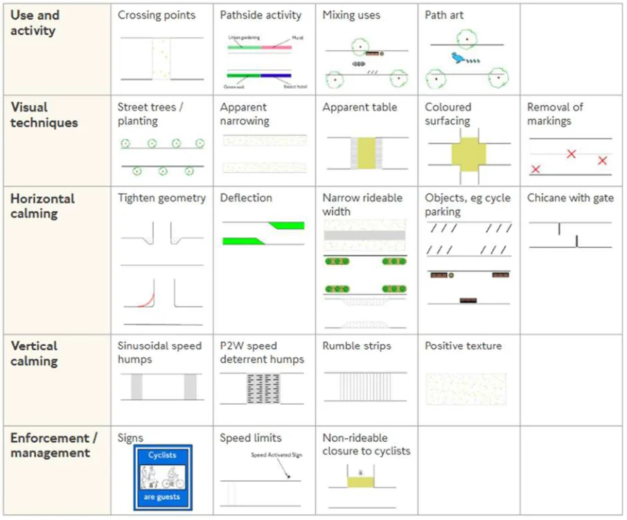
Figure from page 107
Figure B.14 : Cycle Calming Techniques (extract from LCDS)
National Cycle Network Plan - Appendices
National Cycle Network Design Principles
Sustrans have published design principles for the National Cycle Network, however, they are relatively high level and do not provide specific criteria other than ‘be designed in accordance with current best practice design guidance’ (Sustrans, n.d.). Nine design principles are listed:
-
Be traffic-free or a quiet-way.
-
Be wide enough to comfortably accommodate all users.
-
Be designed to minimise maintenance.
-
Be signed clearly and consistently.
-
Have a smooth surface that is well drained.
-
Be fully accessible to all legitimate users.
-
Feel like a safe place to be.
-
Enable all users to crossroads safely and step-free.
-
Be attractive and interesting.
Sustrans does provide guidance on design for two specific link types: low traffic neighbourhoods as well as traffic-free routes and greenways.
The Introductory Design Guide to low traffic neighbourhoods does not include criteria or any geometric guidelines, but rather details the design approach and desired outcomes. It highlights the need for significant community engagement in the design process (Sustrans, n.d.).
The Traffic-free Routes and Greenways Design Guide is more detailed and does provide geometric design recommendations; in particular for widths, horizontal separation from carriageway, horizontal and vertical alignment, and visibility (Sustrans, n.d.).
Accessibility
Although the design and implementation of cycling infrastructure is addressed by local authorities, Sustrans have published guidelines to promote safe and accessible cycling infrastructure which can be accessed online7. One of these is the self-published Cycling for Everyone Report that takes inspiration from the Equality ACT 2010 placing ‘a duty upon the public sector to protect people from discrimination in wider society’ (Sustrans, 2020).
To make cycling more accessible for all people and different cycle types, Sustrans recommends several actions that can be taken to design new and adjust existing cycle infrastructure. Firstly, removing or adjusting barriers on existing cycle infrastructure including gates, access barriers, and steps should be a priority. This includes widening existing routes and designing routes to provide adequate turning space for all cycles. Another action includes ensuring inclusive cycle design infrastructures are set and followed. Sustrans advocate for inclusive design standards developed as part of a wider set of cycling infrastructure standards. This includes improving the consistency of routes (colour, signage, surface materials, etc.) and giving priority to cyclists and pedestrians at junctions. Sustrans recommends introducing continuing professional development (CPD) training for engineers on inclusive cycling including experiential training where transport professionals meet a whole range of users to other perspectives and try-out adoptive cycles. Finally, Sustrans recommends prioritising cycling infrastructure where public transport is poor.
7 Walking and cycling infrastructure design guidance - Sustrans.org.uk, https://www.sustrans.org.uk/forprofessionals/infrastructure/walking-and-cycling-infrastructure-design-guidance
National Cycle Network Plan - Appendices
Lessons Learnt
Fragmented Standards
Allowing each authority to determine their own set of design standards provides the opportunity for quick iteration and flexibility at the local level but has also resulted in a significant duplication of effort with design standards appearing to be very similar. It also means that standards for cross-boundary projects (such as the National Cycle Network) are harder to implement consistently.
Design and Summary Principles
The Design Principles of the Cycle Infrastructure Design Manual provide a purpose or desired outcome while the Summary Principles (or Guiding Principles of the London Cycling Design Standards) provide suggestions on how the outcomes might be achieved. Both are important to include as guidance to designers / planners as part of the design process.
National Cycle Network Plan - Appendices
Netherlands
The Netherlands was selected as an example of ‘best in class’ for both cycle culture, the quality of cycle infrastructure and providing international leadership in cycle design standards. The Netherlands is widely regarded as the world’s most successful cycle nation with over 35,000km of segregated cycle lanes (Dutch Cycling Embassy, 2021). Over one quarter (28%) of all journeys are made by cycling, covering over 17.6 billion kilometres per annum. Cycling in the Netherlands is also considered to be very safe, with less than one fatality per 100 million kilometres cycled.
The L-F Routes in the Netherlands make up the Nederlands Fietsnetwerk (national cycle routes). They are long distance cycling routes that form a network in the Netherlands and Flanders region in Belgium (Holland Cycling Routes, 2022). As of January 2021, they consist of over 3,300km and are generally intended for recreational multi-day cycle tours or cycling holidays. Most L-F routes are signposted in two directions, letters ‘a’ and ‘b’ being used for either direction.
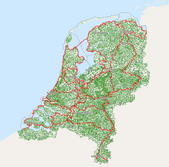
Figure from page 110
Figure B.15 : The Dutch Cycle Network (L-F Routes shown in red and local / regional routes shown in green)
Utrecht is an example of a cycle-friendly city in the Netherlands where over 125,000 cyclists travel into the city each day for work (47% of total commuters) (Gemeente Utrecht, 2019). These come from many of Utrecht’s suburbs such as Hoeten, which alone includes 129km of cycle paths (ITDP Europe, 2019). The link from Hoeten to Utrecht (10 kilometres) is entirely segregated, allowing commuters to travel to work safely and efficiently. Many Dutch towns and cities (including Utrecht) have a ‘soft’ green core that is only accessible to cyclists and pedestrians. Therefore, drivers who want to navigate the town may have to take a lengthy detour via a ring road while cyclists can pass directly through the town centre.
Cycling routes in rural areas are similar to those in the city: Cycle paths (segregated cycling infrastructure) are built where possible and cycle lanes (non-segregated) are also available to use. Highways and “provincial roads” (main roads where the province is responsible for maintenance), are usually fitted with segregated cycle paths.
National Cycle Network Plan - Appendices
As previously mentioned, 35,000km of the country’s cycling infrastructure has been physically segregated from motor traffic (CROW, 2012). On roads and streets where the speed limit is low, cycles share the road with motorists. The surface quality of these cycle paths tends to be good, and the routing is generally direct with gentle turns making it possible to cycle at consistent speeds for considerable distances.
Cycle Policies
The Netherlands has a history of research on effective policies for promoting cycling tracing back to the 1970s. In the Netherlands (like many European countries) cycle usage increased until the 1950s when car ownership became more accessible. In 1975 theFietserbond (Dutch Cyclists’ Union) came into existence in response to the oil crisis in 1973 and the high number of road accidents involving young children at the same time. By the 1990s the central government had initiated many projects outlined in theMasterplan Fiets (Cycle Masterplan). New concepts such as shared-spaces, cycle-streets, and cycle-highways were introduced in this plan and implemented in cities and towns throughout the Netherlands.
CROW is the center for cycle policy for the Dutch Government. The objective of CROW is to develop, disseminate, and exchange practical knowledge to create cycling policy (About CROW, n.d.). The Design Manual for Bicycle Traffic (DMBT) produced by CROW has been influential in creating cycle policies in the Netherlands. Many countries in Europe have taken inspiration from the DMBT to create their own cycle policies. It is perceived to be the gold standard in bicycle design infrastructure manuals (Liu, 2021).
Cycling is heavily encouraged by the national government. Mileage of up to €0.19 per kilometer can be granted and claimed tax-free (government.nl, 2020). This works in much the same way that someone driving their own car for business purposes can claim back a fixed sum related to the distance travelled.
The Dutch invest €487 million annually (as of 2010) in new cycling schemes, cycling research projects, and cycling infrastructure (A View from the Cycle Path, 2010). National government grants account for 40% of the investment in cycle infrastructure, with regional governments providing the rest.
The Design Manual for Cycle Traffic (CROW)
CROW is a non-profit organisation that specialises in road and highway design within the Netherlands and provides support on regulations at a national level (CROW, 2021). The group advises the Directorate- General for Public Works and Water Management (DGPWWM) (formerly Minster of Transport and Water Management), which conducts a role as the practical execution of public works and water management. The DGPWWM is committed to improving quality of life, access and mobility in a clean, safe and sustainable environment. The Design Manual for Cycle Traffic (DMBT) contains all relevant aspects for creating and maintaining effective cycling infrastructure. The manual is a set of guidelines, considered best practice. Nearly all cycle laws in the Netherlands relate back to this document.
The DMBT encourages designers to heed four recommendations at each stage of the design process:
Put yourself in the shoes of the cyclist as future user of the design, also taking into account vulnerable groups of cyclists, such as children and the elderly.
Ensure that facilities fulfil the policy objectives so that they support the policy.
Devote attention to the (spatial planning) integration of cycle facilities in the surrounding area.
See to it that the function, design and use of infrastructure are in equilibrium.
It also documents its fundamental principles and outlines five main requirements that cycle-friendly infrastructure must satisfy:
- Cohesion – The cycle infrastructure forms a cohesive whole and link all origins and destinations that cyclists may have.
National Cycle Network Plan - Appendices
-
Directness – The cycle infrastructure always offers the cyclist as direct a route as possible (detours kept to a minimum).
-
Safety – The cycle infrastructure guarantees the road safety and health (minimum exposure to harmful substances) of cyclists and other road users.
-
Comfort – The cycle infrastructure ensures that cyclists experience minimal nuisance (vibrations, extra exertion due to height differences, trouble from other traffic) and delay (stops).
-
Attractiveness – The cycle infrastructure has been designed and fitted in with its surroundings in such a way that it is appealing or attractive.
The DMBT also includes specific requirements for various cycle infrastructure types. When deciding between implementing cycle lanes and cycle paths it is necessary to consider the safety, exposure to emissions, and available space. CROW takes inspiration from research conducted in the 1980s that concluded that 50% fewer accidents involving injury occurred on segregated cycling infrastructure in comparison with cycle lanes. Exposure to air pollution is a valid reason for choosing a cycle path over a cycle lane, particularly if the cycle path is several meters away from the main road. If less than 11.80m is available for cyclists and motor-vehicles on a dual-carriageway then it would not be possible to implement two one-way cycle lanes correctly.
Dutch law only references one type of cycle lane (on-road cycling infrastructure), separated from the main road with either a broken / dashed line or continuous white line. Where the cycle lane is separated by a broken line motorists may use the cycle lane if absolutely necessary. This means motorists can enter the cycle lane to overtake another vehicle, make way for on-coming traffic, reach a parking bay, or drive down a side street. Driving on a cycle lane where there is a continuous white line is prohibited. In this case, lanes for motor traffic must be wide enough to make it possible for motorists to stay in their own lanes. A cycle lane is only legally a cycle lane when there are bike symbols on the lane. The recommended cycle width is based on the fundamental principle that two cyclists should be able to cycle abreast, either for companionship or for the purposes of overtaking. There should be a minimum gap of 0.5m between cycle lanes and the main road.
Where there is enough space, larger roads are fitted with a parallel fietspad (cycle track / path). These cycle tracks are separated from motorist and pedestrians by a physical means for example by a paved or unpaved verge, a raised curve or another barrier. The minimum width for cycle tracks is 2m, although, they may narrow to 1.5m at certain intersections. Standard widths are generally 2.5m for one-way tracks and 4m for bi-directional cycle tracks. Mopeds are obliged to use cycle tracks when their maximum speed is no more than 25km/h (these are distinguishable with a yellow licence plate).
Some cycle tracks do not follow or run alongside a road and exist to support cyclists with a more direct route to common destinations such as town centres. This complete separation of modes is called the ‘unravelling / unbundling of modes’ and is an important feature of Dutch urban design and traffic management. A lot of roads for motorised traffic have been diverted to go around residential areas especially in the last 10 to 20 years in the Netherlands (Bicycle Dutch, 2012). Municipalities used the opportunity these diversions gave them, to downgrade the original routes to make them fast routes for cyclists. Because traffic is unbundled there are fewer places where different types of traffic have to react, leading to a reduced need for crossings and adding to the overall level of safety.
‘Grey roads’ are a type of cycle lane also included in the Design Manual for Bicycle Traffic. These types of cycling infrastructure are more suited in built-up areas that are too narrow for cycle paths and accommodate a considerable amount of motor-traffic (unspecified). They are essentially cycle lanes without the space for a 0.5m separator between the main road and the cycle lane. Grey roads are generally not recommended as in many situations motor vehicles will have to veer onto the cycle lane due to an oncoming bus or lorry, and cyclists may have to use the driving lane to overtake slower cycles such as cargo bikes.
Fietssnelwegen (cycle highways) andFietsroute+ (intercity routes) have extra features making them more suited to long distance commutes and intercity cycling, such as level and straight stretches,
National Cycle Network Plan - Appendices
absence of traffic lights, level crossings with motorised traffic, and superior pavement quality. These routes are clearly signposted making them easily distinguishable from other cycleways. Cycling interest groups and national and local governments advocate these routes as being a solution for the further reduction of vehicular congestion as cyclists can achieve higher average speeds and maintain them. CROW recommends that cycle highways consist of bi-direction cycle tracks, with the minimum of each uni-directional way being at least 2m wide.
Fietsstraats (cycle streets) are roads where cycles are the primary and preferred choice of transport and where cars and motorised vehicles are allowed as ‘guests’ (Bicycle Dutch, 2022). There are 4 types of fietsstraat, but they are all required to have a speed limit of 30km/h or less and are usually coloured the same red asphalt as cycle paths. These streets generally exist in areas where low-road traffic is expected. Fietsstraats are generally recommended where the volume of cycles is expected to be more than motor vehicles. According to CROW, a road section should only be deemed a fietsstraat if at least 1,000 cycles pass through it in a 24-hour period. On bicycle streets, motor vehicles should be limited to 500 units per 24-hour period.
A summary of the standards of the different cycling infrastructures is given in Table B58.
The CROW design manual also recommends that the ratio of the volume of motor vehicles to the volume of bicycles (both per hour) is considered when designing a road. Figure B16 suggests whether to segregate cycle traffic from motor vehicles, either a cycle highway or cycle path / track, or mix traffic, either through a cycle lane (‘spacious profile’) or bicycle street, based on the volumes of cycle traffic and motor traffic per hour. A ‘tight profile’ is where a motor vehicle must stay behind a cycle when faced with oncoming traffic and usually takes the form of a bicycle street.
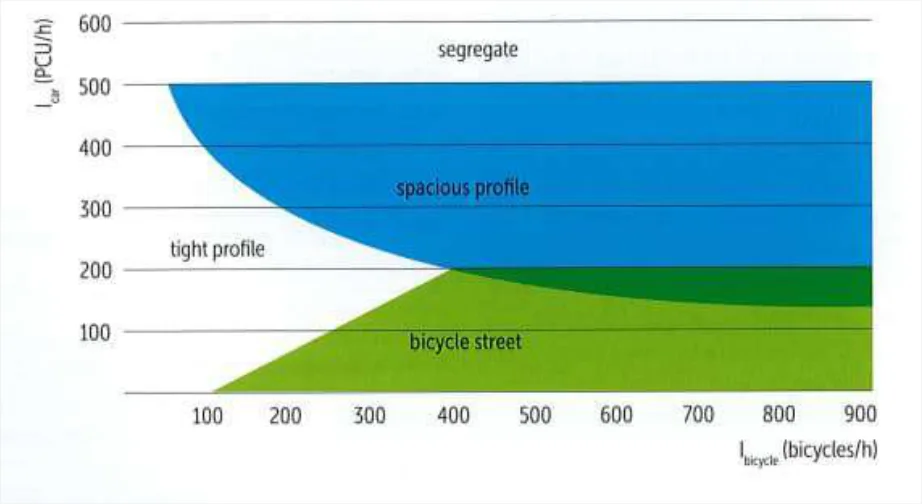
Figure from page 113
Figure B.16 : Suggested Solutions for Profile Choice when Mixing Motorised Traffic and Bicycle Traffic (CROW)
8 CROW – Design Manual for Bicycle Traffic
Table B.5 : Recommended Standards for Varying Types of Cycling Infrastructure (CROW)
| Cycle Route Type | Segregated from main road? | Direction | Markings / Barriers | Desirable minimum width (m) | Absolute | Speed Limit for motorists | Vehicles permitted | ||
|---|---|---|---|---|---|---|---|---|---|
| minimum at | |||||||||
| constraints | |||||||||
| (m) | |||||||||
| Cycle Lane | No | 1-way | Broken white line | 2.3m | 1.5m | Unspecified | Cycles, motorists only if necessary | ||
| No | 1-way | Continuous white line | 2.3m | 1.5m | Unspecified | Cycles only | |||
| Cycle Path/Track | Yes | 1-way | Paved / unpaved verge or raised curve | 2.5m | 1.5m | N/A | Cycles, mopeds <25km/h | ||
| Yes | 2-way | Paved / unpaved verge or raised curve | 4.0m | 3.0m | N/A | Cycles, mopeds <25km/h | |||
| Cycle Highway | Yes (doesn’t follow a road) | 2-way | Unspecified | 2.5m | 2.0m | N/A | Cycles only | ||
| Bicycle Streets | No | 1-way | Usually, a broken white line and coloured red | 2.9m | 1.5m | 30km/h | Cycles, motor- vehicles |
Limiting access to urban cores to pedestrians and cyclists provides an additional incentive to make trips via cycle – as well as separating modes. While this may only be feasible in larger urban centres in Ireland, the idea of providing direct connections to cyclists rather than tracking more circuitous routes built for cars could be applied in many urban and suburban areas. In particular, town bypasses could provide opportunities to allow cyclists a more direct route into town centres when approaching from an interurban route (e.g., the NCN) rather than following new bypass roads that route around the town centre.
The explicit focus of designing from a cyclist’s point of view – including vulnerable groups of cyclists – highlights that the ultimate goal is to have more people using the infrastructure and making trips by cycle. It is important not to lose this perspective at any stage of the design process.
Appendix C
Public and Stakeholder Feedback
National Cycle Network Plan - Appendices
C.1 Written Submissions
Thirty-seven written submissions were received from interested parties and individuals. These submissions are documented in Table C.1. The main recommendations are summarised below – based on the same categories used to analyse the online feedback survey (Corridor Selection, Safety and Amenities and Accessibility).
Table C.1 : Written Submissions Received during Public Consultation
| Organisation / Individual | |||||
|---|---|---|---|---|---|
| Bolt Ireland | East Mayo Greenway Group | Limerick City and County Council | Steven Matthews, TD | ||
| Cara Sport Inclusion Ireland | EirGrid | Limerick branch of the Green Party | Sustrans Northern Ireland | ||
| Cavan County Council | Smugglers Cycling Club | Longford County Council | TIER Mobility UK & Ireland | ||
| Celbridge Cycling Campaign | ISCYcle Project Team, University of Limerick | Donegal County Council | Tipperary County Council | ||
| Connemara Greenway Action Group | Galway Cycling Campaign | Mid West National Road Design Office | Waterways Ireland | ||
| Cork Transport and Mobility Forum | Galway Cycling Solutions | Navan Cycling Initiative | Wexford Bicycle User Group | ||
| Cyclist.ie | Irish Central Border Area Network (ICBAN) | Retail Grocery Dairy & Allied Trades Association (RGDATA) | Wheels of Athenry | ||
| Denis Naughten, TD | Galway City Council | Sligo Cycling Campaign | Meath County Council | ||
| James Atkinson | Fáilte Ireland | Dublin Port Company | Laois County Council | ||
| Sport Ireland |
C.2 Corridor Selection
Many of the submissions included recommendations to extend the network to additional settlements or key destinations. Most of these did not meet the criteria for inclusion on the NCN or were deemed better served by alternative cycle network infrastructure (e.g., greenway, county cycle network). See Appendix E for a detailed analysis of recommendations received regarding the corridor selection.
C.3 Safety
Ten of the written submissions expressed safety concerns over the infrastructure requirements of the NCN plan. The majority of these comments regarded the need for segregated cycle lanes. Many submissions argued that high traffic volume and speed on adjacent roads would create unsafe environments for cyclists if using unsegregated cycle infrastructure, potentially leading to a reduced usage of the NCN. Additionally, to ensure safe access to the NCN throughout the day and across different seasons, a number of submissions mentioned the importance of adequate lighting along the route. These submissions also stressed that a lack of lighting may prevent certain demographic groups, such as women and children, from comfortably cycling during darker periods of the day / year. Other submissions highlighted a lack of safe cycle infrastructure in rural areas and cyclist safety at major roundabouts.
National Cycle Network Plan - Appendices
C.4 Amenities and Accessibility
Eleven of the written submissions expressed concerns regarding the accessibility of the planned NCN. A majority of these responses stressed the importance of seamless experiences through intersections for cyclists. Other submissions expressed concerns over accessibility to the NCN for disabled individuals. Specific concerns regarded the inability for adapted cycles to pass through “kissing gates” and the adapted cycle parking requirements. Additionally, a few submissions highlighted the need to connect cyclists to town centres and schools among other points of interest and stressed the need for these connections to facilitate daily commuting trips.
C.5 Stakeholder Workshops
A series of 1-on-1 meetings or workshops were held with engaged parties at various stages of the project. Initially these focused on raising awareness of the project, receiving feedback on project objectives, and obtaining data regrading existing and planned cycle infrastructure. During Stage 3 of the plan development, it involved a discussion on key destinations and network corridors. Participation in these workshops was high and the various stakeholders were positive regarding the proposals. They provided feedback and guidance on how to proceed with the analysis and insights on areas or issues to be considered when developing the network.
C.6 Public Survey Feedback
The respondents to the survey cycled more frequently compared to a nationally representative sample9
(as might be expected based on engagement with and promotion by cycle advocacy groups).
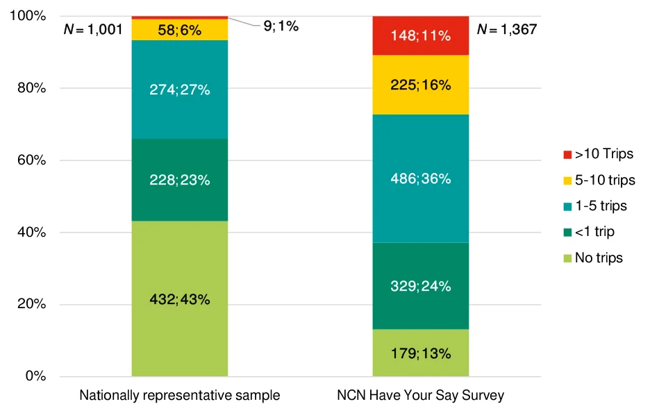
Figure from page 117
100%
| 58; 6% | 9; 1% | 148; 11% |
|---|---|---|
| 225; 16% | ||
| 274; 27% | ||
| 228; 23% | 486; 36% | |
| 432; 43% | ||
| 329; 24% | ||
| 179; 13% |
N = 1,001
80%
60%
40%
20%
0%
Nationally representative sample
Figure C.1 : Cycle Trip Frequency
The vast majority of respondents agreed that they would like to cycle more than they do now and that the provision of safe, connected and inviting cycle infrastructure would encourage them to do so.
9 As capture via market research, see Appendix D
National Cycle Network Plan - Appendices
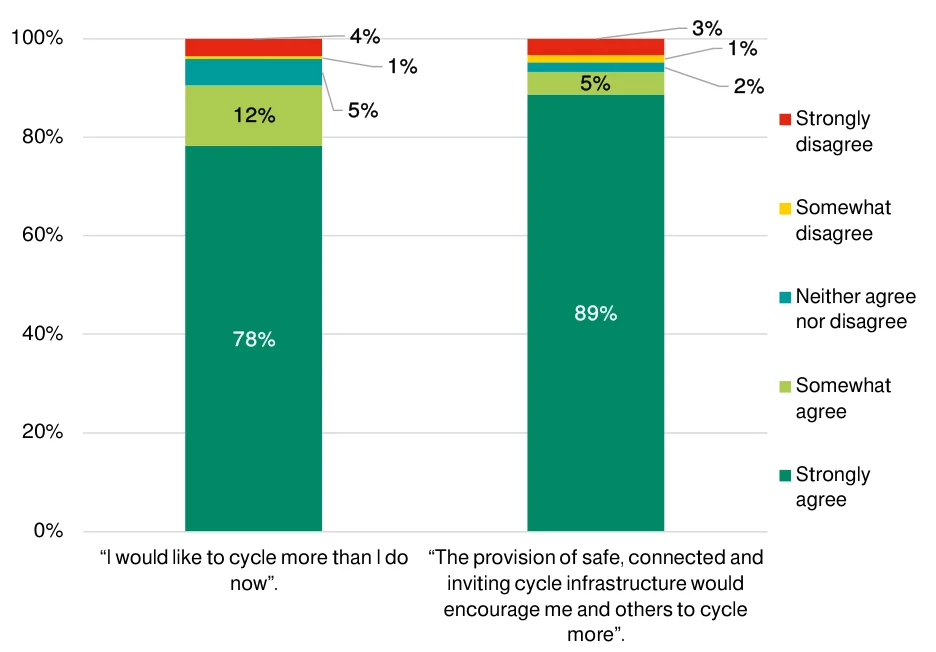
Figure from page 118
100%
| 4% 1% 5% | ||
|---|---|---|
| 5% | ||
| 12% | ||
| 89% | ||
| 78% | ||
80%
60%
40%
20%
0%
“I would like to cycle more than I do
“The provision of safe, connected and
now”.
inviting cycle infrastructure would encourage me and others to cycle
Figure C.2 : Desire to Cycle More and the NCN Plan Vision
Most respondents agreed that the proposed NCN succeeds in achieving the Plan’s objectives.
National Cycle Network Plan – Appendices
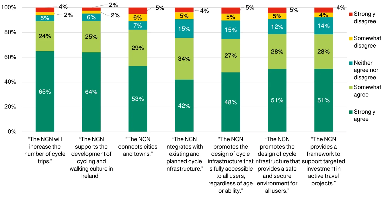
Figure from page 119
100%
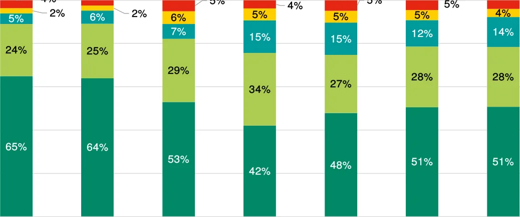
Figure from page 119
80%
60%
40%
20%
0%
“The NCN will
“The NCN supports the development of
increase the number of cycle
connects cities
trips.”
cycling and walking culture in
Ireland.”
Figure C.3 : Proposed NCN and Plan Objectives
National Cycle Network Plan – Appendices
On the survey’s question concerning potential reasons to use the proposed network, 81% of respondents indicated their intention to use the NCN for recreational cycling followed by exercise with 66%. Utility trips to shops or friends and commuting to work / college were third and fourth respectively – see Figure C4.
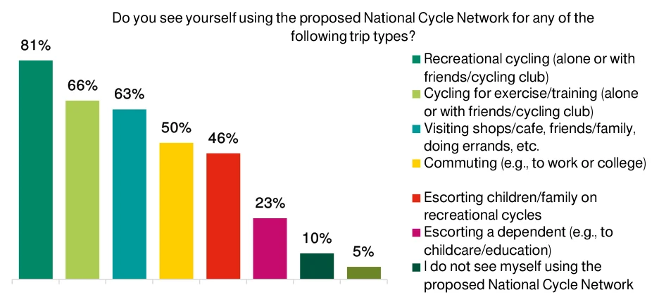
Figure from page 120
Do you see yourself using the proposed National Cycle Network for any of the
following trip types?
81%
66% 63%
50% 46%
23%
10% 5%
Figure C.4 : Potential Future Use of NCN
While only 130 respondents (10%) selected the option of “I do not see myself using the proposed NCN” in the set of closed questions, 216 respondents (16%) provided a detailed response as to why they would or could not use it. Access to the NCN based on the respondent’s home location was the primary reason highlighted (46%). Safety related concerns were the second most popular answer, due to a perceived lack of segregated cycleways in many of the proposed corridors. Figure C.5 presents these responses.
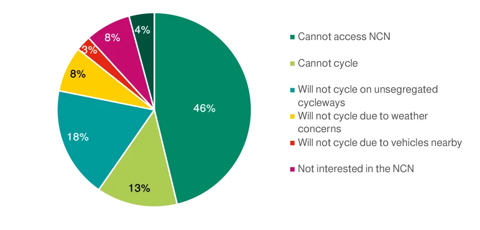
Figure from page 120
4% 8% 3%
8%
46%
18%
13%
Figure C.5 : “If you do not see yourself using the proposed National Cycle Network – Why not?”
Question 8 requested feedback specifically on the SEA Environmental Report – these responses are incorporated in the SEA process. Question 7 of the feedback survey was available for respondents to provide a comment / submission regarding any element of the NCN.
The 889 responses to Question 7 (65% of all submissions) were categorised to better understand respondents’ feedback regarding the proposed NCN. As presented in the figure below, 39% of the comments concerned corridor selection, while 25% of comments related to safety and 18% related to
National Cycle Network Plan – Appendices
both accessibility and the implementation of the NCN Plan. These categories are examined in more detail below.
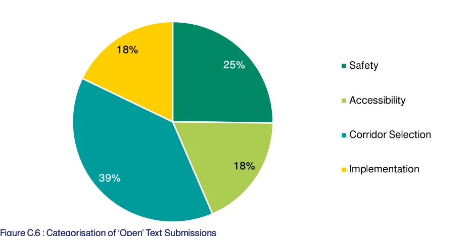
Figure from page 121
18%
39%
Figure C.6 : Categorisation of ‘Open’ Text Submissions
Corridor Selection
343 submissions included a reference to corridor selection. These submissions mainly included requests to extend the network to additional settlements or key destinations. The other two subcategories were related to recommending a new node or changing the alignment of a proposed route – see Figure C7. Appendix E provides a detailed analysis of recommendations received regarding the corridor selection.
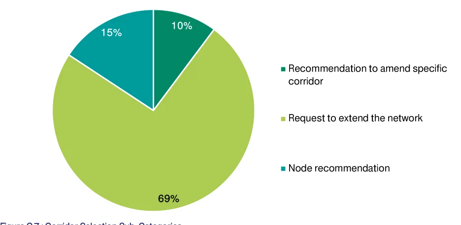
Figure from page 121
10%
15%
69%
Figure C.7 : Corridor Selection Sub-Categories
Safety
224 submissions referenced safety issues. Segregation of cycle infrastructure was the main concern of these submissions - highlighting the preference for physically separating NCN routes from vehicular traffic to provide a safe cycle environment for everyone. The importance of educating cyclists and car drivers was also highlighted. High speeds and volumes of adjacent traffic were two factors identified as impacting cyclists’ safety.
National Cycle Network Plan – Appendices
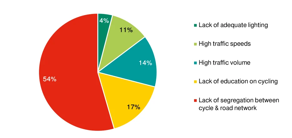
Figure from page 122
4% 11%
54%
Figure C.8 : Safety Sub-Categories
Amenities and Accessibility
163 submissions reference amenities and accessibility issues. These included providing easy access to towns and key destinations, continuous routes at junctions and roundabouts (noting that there is not adequate current infrastructure along junctions for cyclists and drivers to safely travel), as well as access for people with disabilities and general access to cycles. These are presented in the figure below.
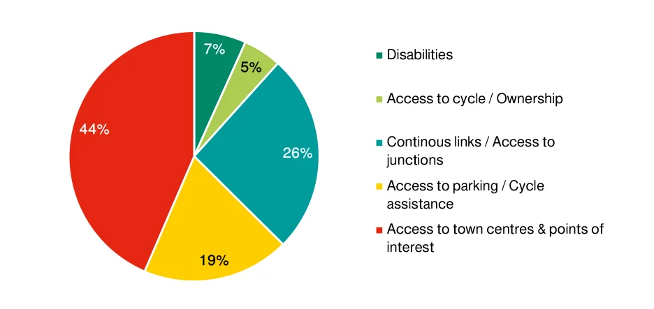
Figure from page 122
7% 5%
44%
19%
Figure C.9 : Amenities and Accessibility Sub-Categories
Implementation
159 submissions referenced the implementation of the NCN. 47% of these discussed incorporating and / or improving existing cycle and other linear infrastructure. Implementation timeline was raised by 26% of these submission and prioritisation of implementation by 19%. 8% discussed the involvement of different entities in the implementation of the NCN. These are presented in the figure below.
National Cycle Network Plan – Appendices
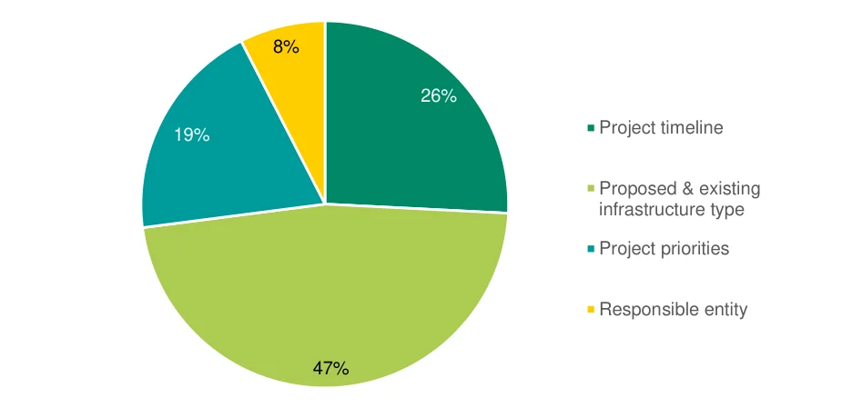
Figure from page 123
8%
19%
47%
Figure C.10 : Implementation Sub-Categories
C.7 Feedback on Proposed Corridors
Feedback received from the public consultation was analysed, as summarised below, and taken into consideration before a review and finalisation of the NCN.
National Cycle Network Plan – Appendices
Table C.2 : Proposed Changes on the NCN from Public Consultation
| Reference | Corridor | Corridor Name | No. of | Rationale | Response | Written Submissions | ||||
|---|---|---|---|---|---|---|---|---|---|---|
| ID | Submissions | |||||||||
| 1 | NA | Athenry to Sligo | 125 | Conversion of the Western Railway Corridor from Athenry to Sligo into a dedicated cycle path would incorporate Athenry, a town with a current population of over 5,000, into the NCN and provide a more direct link to Sligo. The proposed NCN corridors overlap with the Western Railway Corridor at two sections: from Tuam to Claremorris and from Tubbercurry to Sligo. Many submissions voiced opinions in favour of extending the NCN along the remainder of the rail corridor south from Tuam to Athenry and north from Claremorris to Tubbercurry. The proposed advantage of using this corridor is that the right of way is already owned. Opposition to using the Western Railway Corridor as part of the NCN was also voiced in a smaller number of submissions, stating that it would prevent any future reopening of the railway for passenger / freight services. | Inclusion of Athenry a valid concern for NCN – should be reconsidered as part of Galway-Athlone corridor option. Direct connection between Sligo and Athenry not a feasible link in and of itself – dependent on potential for greenway along Western Railway Corridor. Use of Western Railway Corridor not determined under NCN Plan, development of greenway using the facility could be determined under separate greenway project. Minor refinement to Galway- Athlone corridor to include Athenry – no adjustments required along proposed Galway-Sligo corridors. | Wheels of Athenry (promotes inclusion of Athenry in network and highlights potential development of Western Railway Corridor for rail use) East Mayo Greenway Group (promotes converting the railway into cycle infrastructure, focusing on Charlestown to Claremorris) Galway Cycling Campaign (advocates for inclusion of Athenry on the NCN) | ||||
| 2 | NA | Lee to Sea Greenway – Inniscarra Dam to | 30 | Incorporation of this proposed greenway which is within 2km of 157,000 people, serves almost 50,000 students and staff and | Most of the proposed greenway falls under proposed NCN corridors around Cork City – with exception of | Cork Transport and Mobility Forum, TIER Mobility UK & Ireland |
National Cycle Network Plan – Appendices
| Reference | Corridor | Corridor Name | No. of | Rationale | Response | Written Submissions | ||||
|---|---|---|---|---|---|---|---|---|---|---|
| ID | Submissions | |||||||||
| Crosshaven through Cork City | tertiary education centres and will connect business centres with recreational areas | existing infrastructure between Carrigaline and Crosshaven – no adjustment required to proposed NCN. | ||||||||
| 3 | NA | Bandon to Bantry | 15 | Incorporates proposed greenway along existing abandoned railway to attract tourists and provide commuting option in West Cork | Proposed greenway assessed and advanced separately to NCN. Proposed greenway does not connect with any towns >5k population – and thus does not meet the core NCN requirement - no adjustment required to proposed NCN. | |||||
| 4 | NA | Carlow to Enniscorthy | 10 | Connects Bunclody and 60,000 residents along this coast to midlands corridor with the NCN, will encourage both tourism and daily commuting trips along the route | Bunclody population <2k (2016 census), no other towns >1k along proposed route – no adjustment required to proposed NCN. | |||||
| 5 | NA | Cahir to Cashel | 7 | Inclusion of a proposed greenway will provide a connection between tourist areas and will connect Cashel, a town of over 4,000 people | Proposed greenway assessed and advanced separately to NCN. Cashel <5k population (2016 census) and tourist destinations determined to not be NCN nodes in and of themselves – no adjustment required to proposed NCN. |
National Cycle Network Plan – Appendices
| Reference | Corridor | Corridor Name | No. of | Rationale | Response | Written Submissions | ||||
|---|---|---|---|---|---|---|---|---|---|---|
| ID | Submissions | |||||||||
| 6 | 12A | Galway to Castlebar | 6 | Cycle paths along this corridor without existing cycle infrastructure will encourage a modal shift for commuters in towns surrounding Galway with this alternate corridor option. | NCN Corridor 12B performed better than 12A in Corridor Assessment, especially regarding connecting settlements, schools and sports facilities – no adjustment required to proposed NCN. | Galway Cycling Campaign | ||||
| 7 | NA | Westport to Leenane | 5 | Attractive for leisure cyclists, can make use of existing infrastructure to provide coastal access | Leenane population <1k (2016 census), tourist offering better suited to potential greenway network – no adjustment required to proposed NCN. | Galway Cycling Campaign | ||||
| 8 | NA | Rosslare to Waterford | 4 | Redesignating the current railway into a greenway by removing the rail infrastructure would provide a more direct connection through the southern areas of County Wexford. Opposition to the removal of the railway was also voiced. | Potential use of existing rail corridor pending Irish Rail strategic review – no adjustment required to proposed NCN. | |||||
| 9 | NA | Naas to Carlow | 4 | NCN cycleway through this corridor would connect smaller towns (like Brannockstown and Grangecon) with insufficient public transport access to larger population centres. | Both towns listed <1k population (2016 census) – no adjustment required to proposed NCN. | |||||
| 10 | NA | Clonmel to Thurles | 3 | Existing railways can be repurposed into a tourist connection between large population centres in County Tipperary through underserved midlands region. | NCN connects secondary nodes to primary nodes (or to secondary nodes if that is the most appropriate link to the primary node). Suggested link | Tipperary County Council |
National Cycle Network Plan – Appendices
| Reference | Corridor | Corridor Name | No. of | Rationale | Response | Written Submissions | ||||
|---|---|---|---|---|---|---|---|---|---|---|
| ID | Submissions | |||||||||
| better suited to county cycle network – no adjustment required to proposed NCN. | ||||||||||
| 11 | NA | Belleek, Rossnowlagh and Bundoran with Ballyshannon | 3 | Proposed cycleways to connect County Donegal to Northern Ireland via local amenities to increase tourist and leisure activity in the region that aligns with NI Strategic Greenways proposal. | NI Strategic Greenway will be integrated with the NCN – Sligo-Donegal corridor could be adjusted in future based on progress of suggested greenway; no adjustment required to proposed NCN at present. | |||||
| 12 | NA | Great Western Greenway | 2 | Inclusion of the Great Western Greenway will increase access to western parts of the country for tourists and residents alike, emphasising Irelands focus on environmental sustainability. | Great Western Greenway already established and functioning successfully. No settlement >5k (2016 census) west of Westport along the greenway – no adjustment required to proposed NCN. | |||||
| 13 | NA | Buncrana to Inishowen | 2 | Incorporation of this proposed greenway would increase access to beginning of Wild Atlantic Way cycle route in an area underserved by public transport. | Proposed greenway provides connection, no settlement >5k (2016 census) north of Buncrana – no adjustment required to proposed NCN. | |||||
| 14 | NA | Tralee to Dingle | 2 | Current cycleway development lacks segregation and is therefore unsafe for cyclists. | Tourist destination better suited to greenway solution – no adjustment required to proposed NCN. |
National Cycle Network Plan – Appendices
| Reference | Corridor | Corridor Name | No. of | Rationale | Response | Written Submissions | ||||
|---|---|---|---|---|---|---|---|---|---|---|
| ID | Submissions | |||||||||
| 15 | NA | Athenry to Loughrea | 2 | Existing railway corridor between these two population centres can be leveraged to create this connection for leisure and commuting trips. The proposed route would travel north from Loughrea on the existing rail corridor and then west to Athenry. | Minor refinement required to Galway-Athlone corridor to include Athenry. | |||||
| 16 | NA | Middleton to Whitegate | 2 | Cycleway along the harbour would connect various existing cycleways, increasing accessibility in County Cork for tourist and leisure cyclists. | Tourist destination better suited to greenway solution – no adjustment required to proposed NCN. | |||||
| 17 | NA | Dublin to Blessington | 2 | Increases access to iconic cycle route, Wicklow Way, allowing for tourists and commuters a comfortable journey along a corridor currently without segregated cycleways. | Blessington-Naas corridor included in proposed NCN which then connects onto Dublin. Direct Dublin- Blessington connection via Dodder Greenway included in proposed GDA network – no adjustment required to proposed NCN. | |||||
| 18 | 56A | Tullamore to Portaloise | 2 | Proposed revision to provide more direct link between Portlaoise and Tullamore via Mountmellick increasing connectivity between rural regions and providing commuter access to cyclists in Mountmellick | NCN corridor 56B incorporates secondary nodes of Portarlington town and train station so is preferred route – no adjustment to proposed NCN. | |||||
| 19 | NA | Trim to Kilcock | 2 | Proposed revision to provide more direct link between Trim and Kilcock adding cycle infrastructure onto an | Trim connected to Royal Canal Greenway via Ballynakill. Proposed GDA network |
National Cycle Network Plan – Appendices
| Reference | Corridor | Corridor Name | No. of | Rationale | Response | Written Submissions | ||||
|---|---|---|---|---|---|---|---|---|---|---|
| ID | Submissions | |||||||||
| already heavily used cycle corridor and increasing access to the Royal Canal Greenway in Kilcock. | provides link from Trim to Kilcock – no adjustment required to proposed NCN. | |||||||||
| 20 | NA | Farranfore to Caherciveen | 2 | Farranfore, a transportation hub, lacks connection to growing midsized towns in County Kerry. | Proposed greenway covers rural connection – no adjustment required to proposed NCN. | |||||
| 21 | NA | Galway to Spiddal | 2 | No details provided; suggested expansion of network. | No settlement >5k (2016 census), better suited to county cycle network – no adjustment required to proposed NCN. | Galway Cycling Campaign | ||||
| 22 | NA | Wexford to New Ross | 2 | Suggested as a contingency route for County Wexford if other routes are not feasible. Proposed to run alongside the N25. | Proposed Wexford-New Ross corridor aligns with other regional corridors and reduces potential parallel / duplicate sections – no adjustment required to proposed NCN. | Wexford Bicycle User Group, Cyclist.ie | ||||
| 23 | NA | Navan to Clonee | 2 | Proposed additional corridor connecting Navan more directly with Dublin via Clonee (rather than via Swords). No details provided; suggested expansion of network. | Proposed GDA cycle network provides suggested link – no adjustment required to proposed NCN. | Meath County Council, Navan Cycling Initiative | ||||
| 24 | NA | Carrickmacross to Longford | 1 | Network south of border deemed to be light, suggestion of increasing density by connecting Carrickmacross to Longford. | Additional East / West route would connect Bailieborough (2.7k) and Ballyjamesduff (2.7k). Very long connection of secondary node to non- adjacent primary node – no |
National Cycle Network Plan – Appendices
| Reference | Corridor | Corridor Name | No. of | Rationale | Response | Written Submissions | ||||
|---|---|---|---|---|---|---|---|---|---|---|
| ID | Submissions | |||||||||
| adjustment required to proposed NCN. | ||||||||||
| 25 | NA | Ballybofey to Glenties | 1 | Access to central County Donegal can be increased by developing cycle path along this corridor’s abandoned railway. | No settlements >1k (2016 census) connected – no adjustment required to proposed NCN. | |||||
| 26 | 85A | Longford to Cavan | 1 | Proposed revision to provide more direct link between Longford and Cavan by choosing this alternative corridor option, providing access to inland rural towns. | While NCN corridor 85A is the most direct connection between the two nodes, it performed the poorest amongst the three options – no adjustment required to proposed NCN. | |||||
| 27 | NA | Boyle to Ballaghaderreen | 1 | No details provided; suggested expansion of network. | Boyle is included on the Longford-Sligo corridor. Ballaghaderreen is settlement of approximately 2k (2016 census) with no other settlements >1k between it and Boyle – no adjustment required to proposed NCN. | |||||
| 28 | NA | Waterford to Kerry via Mallow and Fermoy | 1 | No details provided; suggested expansion of network to include a planned greenway and extension west from Mallow. | Proposed greenway connects Dungarven to Mallow (via Fermoy). All suggested connections are between secondary nodes. No primary node included – no adjustment required to proposed NCN. |
National Cycle Network Plan – Appendices
| Reference | Corridor | Corridor Name | No. of | Rationale | Response | Written Submissions | ||||
|---|---|---|---|---|---|---|---|---|---|---|
| ID | Submissions | |||||||||
| 29 | NA | Carnew to Gorey | 1 | Provide safe cycle access to busy commuter corridor. | Carnew town of approximately 1k (2016 census), connection to Gorey better aligned to county network – no adjustment required to proposed NCN. | |||||
| 30 | 50A | Enniscorthy to Wexford | 1 | Route option A on this corridor can use the existing Macmine rail line and wide shoulders on N11 for fully segregated cycleway. | NCN corridor 50A scored well in the Options Assessment, but corridor 50B aligns with other corridors and reduces potential parallel / duplicate sections – no adjustment required to proposed NCN. | Wexford Bicycle User Group | ||||
| 31 | NA | Roscrea to Birr | 1 | Connection between the heritage site of Birr and Roscrea would facilitate active transport and access to larger cities for residents along this corridor. | Birr settlement of approximately 4.4k (2016 census), Roscrea included on NCN as a secondary node. Connection within 20km trip distance, but better aligned to county network – no adjustment required to proposed NCN. | |||||
| 32 | 83B | Drogheda to Dundalk | 1 | No details provided; suggested revision of network to alternative corridor option. | NCN corridor 83B performed well in the Options Assessment, but the selected corridor 83C aligns with a GDA cycle network proposed coastal greenway project – no adjustment required to proposed NCN. |
National Cycle Network Plan – Appendices
| Reference | Corridor | Corridor Name | No. of | Rationale | Response | Written Submissions | ||||
|---|---|---|---|---|---|---|---|---|---|---|
| ID | Submissions | |||||||||
| 33 | 73B | Dublin to Naas | 1 | Existing roadway in poor condition resulting in cycle tire punctures. | NCN corridor 73B performed well in the Options Assessment, but the selected corridor 73B aligns with the planned Grand Canal Greenway project. A parallel corridor via the Dodder Greenway is included in proposed GDA network – no adjustment required to proposed NCN. | |||||
| 34 | NA | Wicklow to Rathdrum | 1 | Cycleways along this corridor would increase interconnectivity between NCN and regional rail network through connection with Rathdrum train station on Connolly-Rosslare line. | Rathdrum settlement of approximately 1.6k (2016 census), Wicklow included on NCN as a secondary node. Connection within 20km trip distance, but better aligned to county network – no adjustment required to proposed NCN. | |||||
| 35 | NA | Wicklow to Roundwood | 1 | Connections within Wicklow can increase cycle accessibility for tourists to various attractions. | Roundwood settlement of <1k (2016 census), Wicklow included on NCN as a secondary node. Connection within 20km trip distance, but better aligned to county network – no adjustment required to proposed NCN. |
National Cycle Network Plan – Appendices
| Reference | Corridor | Corridor Name | No. of | Rationale | Response | Written Submissions | ||||
|---|---|---|---|---|---|---|---|---|---|---|
| ID | Submissions | |||||||||
| 36 | NA | Wicklow to Laragh | 1 | Connections within Wicklow can increase cycle accessibility for tourists to various attractions. | Laragh settlement of <1k (2016 census), Wicklow included on NCN as a secondary node. Connection within 20km trip distance, but better aligned to county network – no adjustment required to proposed NCN. | |||||
| 37 | 13A | Castlebar to Longford | 1 | Existing railway corridor can be leveraged to include Swinford into the NCN by choosing this alternative corridor option. | NCN corridor 13B scored better than 13A in the Options Assessment, particularly regarding settlements. It also aligns better with other proposed corridors reducing duplicate infrastructure – no adjustment required to proposed NCN. | |||||
| 38 | NA | Integration with Liffey Tolka Project | 1 | Incorporation of these planned cycleways along Dublin Port will create more widespread access to the larger NCN network for cyclists in this area of the city and vice versa. | Dublin Port included as secondary node on NCN. Integration with planned Tolka Project could be included as part of Connolly-Dublin Port corridor, but NCN would not incorporate entire route of proposed Liffey Tolka Project. | Dublin Port Company |
Appendix D
Market Research Findings
National Cycle Network Plan – Appendices
Findings and Insights from Response to Nationally Representative Survey
| Question / | Findings | Insights | ||
|---|---|---|---|---|
| Theme | ||||
| Who Cycles? | Those who cycle more are generally more confident cyclists Those aged 55+ are over-represented in non- cyclists and those aged 35-44 are over- represented in Enthusiastic Cyclists Female representation decreases with trip frequency ABC1 socio-economic group10 is over- represented in Enthusiastic Cyclists Those living in larger settlements tend to cycle more frequently E-cycle ownership increases with frequency of trips, although Enthusiastic Cyclists are less likely than Daily Cyclists to own e-cycle (38% compared to 43%) E-cycle owners tend to cycle more frequently, than non-motorised cycle owners While the vast majority of respondents would like to cycle more (80%), desire to cycle aligns more with current cycling confidence level | There is a large cohort of the population currently not cycling who want to cycle (approximately 20% of the general population) The more confident a person is on a cycle, the more they want to cycle and the more frequently they cycle – increasing general cycling confidence should increase both the number of active cyclists and cycle trips Campaigns to increase cycling may need to target differing needs of segments; women, those aged 55+ and more rural residents are all less likely to cycle | ||
| Where do they Cycle? | While lower in rural areas, the majority of people own or have access to a cycle Large town and small town residents show the highest desire to own / access a cycle Respondents less likely to commute by cycle than take a trip by cycle for visiting, recreation or exercise Most cyclists make trips of <5km, except for recreational (non-family) and exercise trips which are on average longer (54% and 53% respectively) E-cycles increase the percentage of cyclists making 5-20km commuting trips, but not those making >20km trips. | Cycle access / ownership programs might be beneficially targeted at rural and small town residents More people cycle for recreational purposes than commuting purposes, although commuting trips may represent a large proportion of total trips Longer distance trips (>10km) should cater more towards recreational and exercise use / preferences Significant increase in >20km commutes potentially limited with increased adoption of e- cycles | ||
| Infrastructure Preferences | Safety is the top factor influencing a person’s decision to make a trip by cycle Enthusiastic Cyclists rank safety and security lower, but adjacent traffic volume and speed higher than other groups as well as the need to transport people / items Women rank safety and security higher than men, but this decreases with age – “None of | Even those with no confidence cycling in general feel some level of confidence, on average, on a greenway or cycleway Providing safe segregated cycle infrastructure should increase general cycling confidence and be the |
10 CSO classification to represent ‘Professional workers’
National Cycle Network Plan – Appendices
| Question / | Findings | Insights | ||
|---|---|---|---|---|
| Theme | ||||
| the above” is top ranked in 55+ age group11. Men consistently rank safety and security as top factor, but similar to women “None of the above” also increases with age. Segregated cycle infrastructure (greenways and cycle tracks) is preferred for >60% of respondents across all trip types. Regional / local roads and grey ways score highest for exercise use (7%). The more frequently you cycle, the more confident a cyclist you are Cycling confidence is impacted by infrastructure; average confidence on greenways and cycle tracks increases even for those with no confidence Women are less confident cyclists than men across all age groups and appear to lose confidence with age | preferred option for most cyclists across all trip types Safety should be the top priority for infrastructure design Ingrained behaviour / preferences may limit change to cycling behaviour in older age groups | |||
| Route Preferences | Most people are willing to divert commuting trips for segregated cycle infrastructure Preference between using a regional road or national road (with cycle lane) is not clear cut, with exception of Enthusiastic Cyclists who strongly prefer using a regional road More direct long-distance trips are slightly preferred in general (44% compared to 37%), with the exception of Enthusiastic Cyclists who have a strong preference for longer greenway routes (48% compared to (28%) There is general agreement that pedestrians should share space with cyclists on greenways (53% agree, 27% disagree) | Cyclists will take a longer route to use safer infrastructure Enthusiastic Cyclists have preferences distinct to other cyclist segments, but are a small proportion of cyclists overall Greenways should continue to facilitate both pedestrians and cyclists |
11 The response options to the question “What factors influence your decision to make a trip by cycle?” were: i) Safety and Security, ii) Need to transport other people or items, iii) Bicycle parking at destination, iv) Landscape/ scenery, v) Adjacent traffic speed, vi) Adjacent traffic volume, vii) Gradient, viii) Number of junctions, ix) Other (option to specify), and x) None of the
Appendix E
Corridor Assessment
National Cycle Network Plan – Appendices
This Appendix outlines the Assessment Framework developed to determine the best performing Corridor, where multiple Corridor Options between two nodes had been identified.
It also includes a series of tables presenting the assessment of the corridor options considered for the NCN and a summary of the preferred corridor options.
E.1 Approach
Where multiple options for NCN Corridors had been identified, the performance of each option was determined by consideration against a range of assessment criteria as described below. The assessment of Corridor Options against these criteria was informed by a series of specific data sets.
| NCN Plan Objectives | NCN Assessment | Data Set | ||
|---|---|---|---|---|
| Criteria | ||||
| Increase the number of cycle trips by improving the provision of safe and attractive cycling infrastructure. Connect to strategic destinations outside of urban areas as appropriate (including centres of education, centres of employment, and leisure destinations). | Commuter Trips | Database of smaller settlements between the 1,000 and 5,000 population (Other Nodes) | ||
| School Trips | Data base of Primary and Secondary Schools - Developed by AECOM | |||
| Leisure Trips | Data base of leisure facilities – including sports clubs and off-road trails - Developed by AECOM | |||
| Promote the design of cycling infrastructure that meets safety requirements. Promote the design of cycling infrastructure that provides a safe and secure environment for all users. | Potential Safety Impacts | National Transport Models Road Network showing flows in the form of AADT, posted speed limits and average speeds. | ||
| Integrate with existing and proposed cycling infrastructure (including greenways, safe routes to schools, the EuroVelo network, Interreg projects), as appropriate Incorporate existing greenways, disused railways, canals, bypassed national roads, regional and local roads, long distance trails, as appropriate. Propose corridors to maximise the number of users. Future-proof cycle route capacity, taking account of population growth and additional demand from modal shift. Connect to strategic destinations outside of urban areas as appropriate (including centres of education, centres of employment, and leisure destinations). | Integration with Existing Cycle Infrastructure | Database of existing cycle infrastructure – including greenways, Blueway’s and Eurovelo routes – developed by AECOM | ||
| Integration with Planned Cycle Infrastructure | Database of proposed cycle infrastructure – including greenways, Blueway’s and Eurovelo routes – developed by AECOM | |||
| Integration with Existing Infrastructure | Database of disused railways developed by AECOM | |||
| Integration with transport modes | Database of train stations - Developed by AECOM | |||
| Integration with Tourist Attractions | Fáilte Ireland database of tourist attractions with visitor numbers <200k total visitors in 2019. | |||
| Scenery and Route Attractiveness | ESRI Basemap |
National Cycle Network Plan – Appendices
| NCN Plan Objectives | NCN Assessment | Data Set | ||
|---|---|---|---|---|
| Criteria | ||||
| Enhance local environments and biodiversity where possible (e.g., pollinator plans, green corridors). Support the development of cycling and walking culture in Ireland. | Impact on sensitive areas | Database of Special Protection Areas, Special Areas of Conservations and Proposed National Heritage Areas / National Heritage Areas and architectural conservation areas – Developed by AECOM. | ||
| Connect to strategic destinations outside of urban areas (including transport hubs and tourist destinations), as appropriate. | Social Inclusion | Pobal deprivation index - Developed by AECOM | ||
| Integration with Smaller Settlements | Database of smaller settlements between the 1,000 and 5,000 population (Other Nodes) | |||
| Gradient | ESRI Contour Maps |
E.2 Assessment Methodology
Geospatial analysis of multiple datasets was central to the assessment of options. ArcGIS was used extensively to undertake the assessment of corridor options. A 2km buffer was applied from the centre line of indicative routes to give a 4km assessment zone along each of the NCN Corridors. Within these 4km corridors key assessment criteria as describe above were calculated to inform a multi criteria analysis of options.
The results of the geospatial analysis for each option were then manually compared against the other option(s) for the same corridor under each of the categories listed here – see Section E.3.
Demand
The NCN Plan aims to increase demand for cycling and walking by improving the provision of safe and attractive active travel infrastructure. Acting as a multifunctional network available for leisure users, tourists, and commuters.
Commuting Trips
The existing level of commuting demand was estimated for each Corridor Option based on populations in the area using the CSO settlements shapefile. The higher the population the higher the potential commuting demand for an option under consideration.
Leisure Trips
To assess how each Corridor Option promotes the use of active modes for leisure trips a database of leisure locations was compiled, containing the location of sporting clubs, off-road cycle trails and other leisure facilities. Corridor Options were then buffered12 in ArcGIS and intersected with leisure facility locations. The number of locations within the Corridor buffer was counted and compared across Corridor Options to highlight the best performing Option.
School Trips
A database of all primary and secondary school locations in the country was compiled and plotted in ArcGIS. Corridor Options were then buffered13 in ArcGIS either side of the Option and intersected with the location of schools. The number of schools within the Corridor Option buffer was counted and compared across Corridor Options to highlight the best performing Option.
12 2km buffer is applied in all areas 13 2km buffer is applied in all areas
National Cycle Network Plan – Appendices
Safety
The NCN Plan aims to deliver a cycle network which incorporates modern design principles and drives improvements in cycle safety nationally which is a central objective of the NCN Plan.
Potential Safety Impacts
To assess the potential safety impacts on Corridor Options the National Model Road Network was used to identify National Roads, the traffic flow on these roads in the form of Annual Average Daily Traffic (AADT), posted speed limits and average speed. Crossings of National Roads was also taken into account and compared across Corridor Options.
Integration
Corridor Options were assessed on how well they integrate with existing and planned transport infrastructure. The NCN will promote integration with local planning policies and integration in respect to land-use activities as well as other strategy proposals.
Integration with Existing Infrastructure
To assess how well Corridor Options integrate with existing infrastructure, a buffer was applied to the route corridors. This buffer zone was assessed against a database of existing Greenways, Blueways and Eurovelo routes, which was developed by AECOM. The number of connections and length overlapping with existing infrastructure were counted and compared against other route corridors to determine the level of integration with existing infrastructure provided by each option.
Integration with Planned Infrastructure
To assess how well Corridor Options integrate with proposed infrastructure a buffer was applied to the route corridors. This buffer zone was assessed against a database of planned Greenways, Blueway’s and Eurovelo routes, which was developed by AECOM. The number of connections and length overlapping with planned infrastructure was counted and compared against other route corridors to determine the level of integration with existing infrastructure provided by each option.
Integration with Other Existing Alignments
To assess how well Corridor Options integrate with proposed infrastructure a buffer was applied to the route corridors. This buffer zone was assessed against a database of historical rail routes, which was developed by AECOM. The number of connections and length overlapping were counted and compared against other route corridors to determine the level of integration with other existing alignments provided by each option.
Integration with Transport Modes
The proximity of cycle infrastructure to appropriate train stations can impact the level of demand and utilisation of the route being the only public transport mode that integrates with cycling. The proximity of a Corridor Option to appropriate train stations was assessed based on the number of train stations within the buffer. The number of stations was counted within a Corridor Option and ranked against other Options.
Integration with Tourist Attractions
There is a need to facilitate enhancements to access tourism facilities via active travel modes. The NCN Plan seeks to provide connections to priority tourist destinations where possible. This was assessed using a database of visitor attractions counting the number of attractions within the assessment corridor.
Scenery and Route Attractiveness
National Cycle Network Plan – Appendices
The NCN Plan seeks to provide aesthetically attractive routes for its users. Irelands landscape is rich and varied, with diverse lowland and upland, lake, river, and shore character areas. Enhanced active travel networks have the potential to support the enjoyment and understanding of Ireland’s diverse landscapes. This was assessed based on an option’s interaction with the natural environment and landscape.
Environment and Biodiversity
Corridor Options were assessed on how they potentially might impact the environment by considering how options impinge on designated and sensitive sites. To assess the impact on the natural and built environment a database of designated sites was compiled which included:
Special Protection Areas.
Special Areas of Conservation.
Proposed National Heritage Areas / National Heritage Areas.
Sensitive natural environmental sites.
Architectural conservation areas.
These sites were mapped in GIS to highlight areas of potential concern. The number of interactions per route corridor were then recorded and compared across corridor options to determine the performance of options with respect to their impact on sensitive areas.
Corridor Options were assessed under the Strategic Environmental Assessment (SEA) and Appropriate Assessment (AA) processes to determine the potential impacts of Corridor Options ensuring those with potentially significant negative impacts were not brought forward to the next step. The results of the SEA and AA can be reviewed in Appendix G, Appendix H and Appendix I. The results from the Strategic Environmental Assessment were a key consideration in the corridor selection process for the NCN Plan.
Accessibility and Social Inclusion
The NCN Plan promotes social inclusion for marginalised groups, interchange between transport modes and low gradient routes.
Social Inclusion
In order to assess the potential of Corridor Options to improve social inclusion, the Pobal HP Deprivation Index was used. To assess the impact, Corridor Options were plotted in ArcGIS and then intersected with the Pobal Deprivation Index. The number of connections with each area were counted and compared across Corridor Options.
Integration with Smaller Settlements
In developing Corridor Options emphasis was placed on making connections with existing settlements that fall below the population thresholds to be considered as Primary or Secondary Nodes. This was assessed using the CSO Settlements shapefile filtered to excluded settlements included as Primary or Secondary Nodes.
Gradient
Severe gradients have a negative impact on the likelihood of people switching to cycling. This element informed the scoring and ranking of Corridors in terms of their demand. Options were ranked based on their route through contour maps with the route with the least amount of gradient change being more favourable.
National Cycle Network Plan – Appendices
E.3 Scoring System
A 5-point Likert scale was used to analyse the different corridor options. The highest rank given showing major advantages compared to the other option(s) and the lowest rank given showing major disadvantages compared to other option(s). This is outlined below. The scores were assigned manually based on a review of the output from the GIS analysis of each option.
| Major advantages over other option(s) | 2 | ||
|---|---|---|---|
| Minor advantages over other option(s) | 1 | ||
| Comparable to other option(s) | 0 | ||
| Minor disadvantages over other | -1 | ||
| option(s) | |||
| Major disadvantages over other | -2 | ||
| option(s) |
E.4 Assessment Summary
Following the analysis and options assessment outlined in the method above, the preferred corridor options are listed below. Full details of the assessment for each corridor are provided in Section E.5.
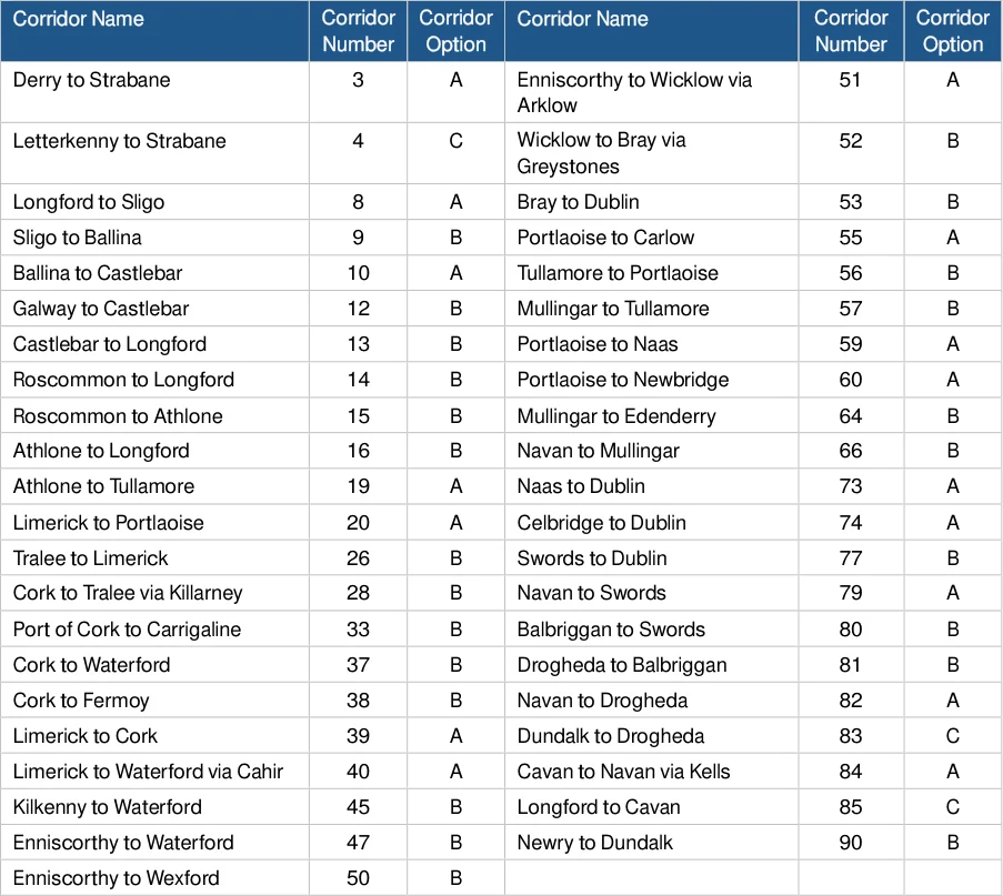
Figure from page 142
National Cycle Network Plan – Appendices
E.5 Assessment Details
Options assessments are detailed here. Specifically, the options were assessed based on estimated demand, safety, integration with existing and planned cycle infrastructure, environmental impacts, social inclusion, and connectivity to smaller settlements, transport modes and tourist attractions.
These options, which have been mapped below, explore different potential corridors for linking the nodes identified for the NCN. The tables presented below examine the differences between corridor options in relation to each of the criteria outlined in the previous chapter and utilise the scorings represented in the key below.
The Corridor Options were also assessed as part of the SEA to identify preferred corridors specifically from an environmental perspective – the results of this assessment are contained in the SEA Environmental Report.
Where the corridor options assessment detailed in this section identified a major advantage / disadvantage regarding the environmental category of sensitive areas, the findings of the SEA Environmental Report were integral to determining a distinct preferred option.
Maps:
The maps included in this section show specific sets of corridor options under assessment. Each map shows a certain section of the overall network and contains multiple corridors (which are referenced in the corresponding tables that follow) and the corridor options can be identified by:
Option A is outlined in red (–)
Option B is outlined in a dashed blue (–)
Option C (where applicable) is outlined in a dashed green (–)
Corridors with no options for assessment (and not detailed in this appendix) are marked with a thick blue line
National Cycle Network Plan – Appendices
Derry to Strabane
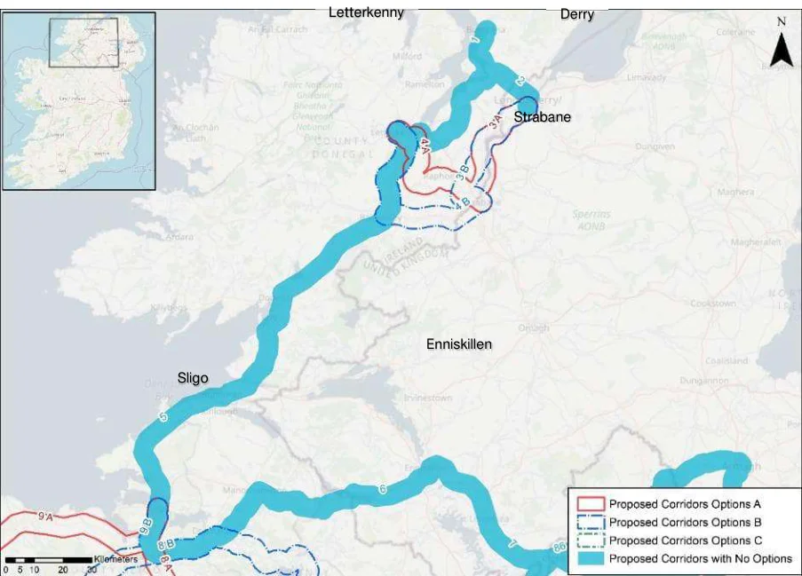
Figure from page 144
Sligo
Figure E.1 : Corridor Options 1-5
Table E.1: Derry to Strabane
| Corridor 3 - Derry to Strabane | A | B | |||||||
|---|---|---|---|---|---|---|---|---|---|
| Eastern Option | Western Option | ||||||||
| Demand | Commuting Trips | 0 | 0 | ||||||
| School Trips | 0 | 0 | |||||||
| Leisure Trips | 0 | 0 | |||||||
| Safety | Potential Safety Impacts | 0 | 0 | ||||||
| Integration | Integration with existing cycle infrastructure | 0 | 0 | ||||||
| Integration with planned cycling infrastructure | 2 | -2 | |||||||
| Integration with other existing alignments | 2 | -2 | |||||||
| Integration with transport modes | 0 | 0 | |||||||
| Integration with Tourist Attractions | 0 | 0 | |||||||
| Scenery and Route Attractiveness | 2 | -2 | |||||||
| Environment | Impact on sensitive areas | -2 | 2 | ||||||
| Accessibility & Social inclusion | Social Inclusion | 0 | 0 | ||||||
| Integration with Smaller Settlements | 0 | 0 | |||||||
| Gradients | 0 | 0 |
National Cycle Network Plan – Appendices
The Derry to Strabane Corridor has two options. Option A or the Eastern Option diverges east at Upper Maymore crossing the Deele River at Ballindrait whereas Option B diverges west at Upper Maymore, following the River Foyle.
Option A is preferred due to its alignment with planned cycling infrastructure and other alignments, as well as route attractiveness.
Letterkenny to Strabane
Table E.2: Letterkenny to Strabane
| Corridor 4 - Letterkenny to Strabane | A | B | |||||||
|---|---|---|---|---|---|---|---|---|---|
| via Raphoe | via Ballybofey | ||||||||
| Demand | Commuting Trips | 0 | 0 | ||||||
| School Trips | 0 | 0 | |||||||
| Leisure Trips | 0 | 0 | |||||||
| Safety | Potential Safety Impacts | 0 | 0 | ||||||
| Integration | Integration with existing cycle infrastructure | 0 | 0 | ||||||
| Integration with planned cycling infrastructure | 0 | 0 | |||||||
| Integration with other existing alignments | 0 | 0 | |||||||
| Integration with transport modes | 0 | 0 | |||||||
| Integration with Tourist Attractions | 0 | 0 | |||||||
| Scenery and Route Attractiveness | 0 | 0 | |||||||
| Environment | Impact on sensitive areas | 2 | -2 | ||||||
| Accessibility & Social inclusion | Social Inclusion | 0 | 0 | ||||||
| Integration with Smaller Settlements | 0 | 0 | |||||||
| Gradients | 0 | 0 |
The Letterkenny to Strabane Corridor has two options, Option A via Raphoe and Option B via Ballybofey.
Option A is preferred due to its low interference with the River Finn SAC.
National Cycle Network Plan – Appendices
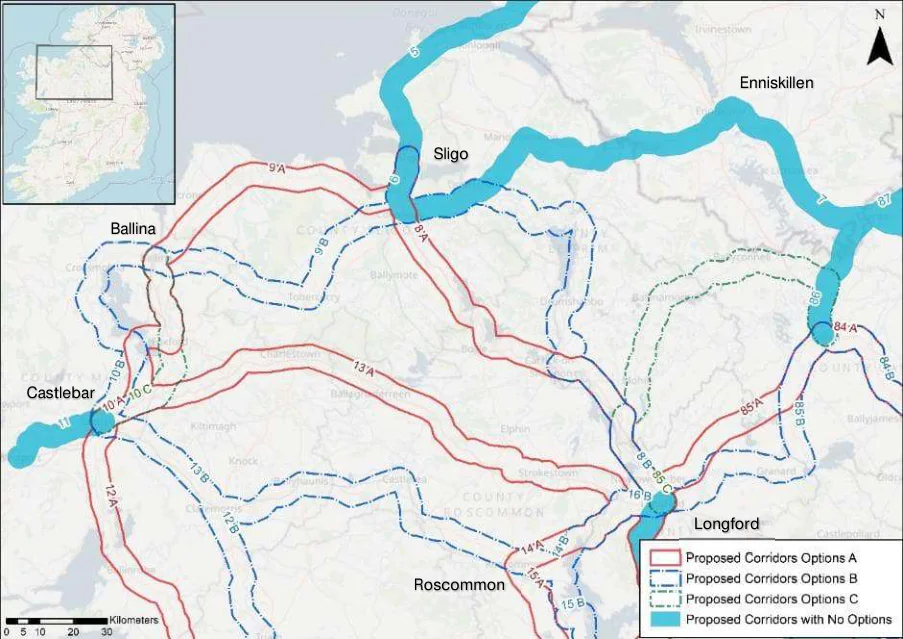
Figure from page 146
Ballina
Castlebar
Figure E.2 : Corridor Options 6-10
Longford to Sligo
Table E.3: Longford to Sligo
| Corridor 8 - Longford to Sligo | A | B | |||||||
|---|---|---|---|---|---|---|---|---|---|
| via Lough Arrow & Key | via Lough Allen | ||||||||
| Demand | Commuting Trips | -1 | 1 | ||||||
| School Trips | -1 | 1 | |||||||
| Leisure Trips | 0 | 0 | |||||||
| Safety | Potential Safety Impacts | 0 | 0 | ||||||
| Integration | Integration with existing cycle infrastructure | 2 | -2 | ||||||
| Integration with planned cycling infrastructure | 2 | -2 | |||||||
| Integration with other existing alignments | -1 | 1 | |||||||
| Integration with transport modes | 1 | -1 | |||||||
| Integration with Tourist Attractions | 0 | 0 | |||||||
| Scenery and Route Attractiveness | 0 | 0 | |||||||
| Environment | Impact on sensitive areas | 0 | 0 | ||||||
| Accessibility & Social inclusion | Social Inclusion | 0 | 0 | ||||||
| Integration with Smaller Settlements | -1 | 1 | |||||||
| Gradients | 0 | 0 |
The Longford to Sligo Corridor has two options. Option A via Lough Arrow and Lough Key and Option B via Lough Allen. The options split at Collooney and reconverge at Carrick-on-Shannon.
Option A is the preferred option due to its integration with the Collooney to Castlebaldwin Greenway along with the planned Lough Key to Carrick-On-Shannon Greenway.
National Cycle Network Plan – Appendices
Sligo to Ballina
Table E.4: Sligo to Ballina
| Corridor 9 - Sligo to Ballina | A | B | |||||||
|---|---|---|---|---|---|---|---|---|---|
| via N59 | via Tobercurry | ||||||||
| Demand | Commuting Trips | -2 | 2 | ||||||
| School Trips | 1 | -1 | |||||||
| Leisure Trips | -1 | 1 | |||||||
| Safety | Potential Safety Impacts | -1 | 1 | ||||||
| Integration | Integration with existing cycle infrastructure | -2 | 2 | ||||||
| Integration with planned cycling infrastructure | 0 | 0 | |||||||
| Integration with other existing alignments | -2 | 2 | |||||||
| Integration with transport modes | -1 | 1 | |||||||
| Integration with Tourist Attractions | 1 | -1 | |||||||
| Scenery and Route Attractiveness | -1 | 1 | |||||||
| Environment | Impact on sensitive areas | 1 | -1 | ||||||
| Accessibility & Social inclusion | Social Inclusion | 1 | -1 | ||||||
| Integration with Smaller Settlements | -2 | 2 | |||||||
| Gradients | 1 | -1 |
The Sligo to Ballina Corridor has two options. Option A via N59 and Option B via Tubbercurry.
Option B is the preferred option due to its integration with smaller settlements and the existing Bellaghy - Charlestown - Collooney Greenway to Tubbercurry..
Ballina to Castlebar
Table E.5: Ballina to Castlebar
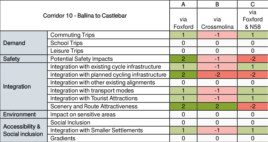
Figure from page 147
The Ballina to Castlebar Corridor has three options, Option A via Foxford, Option B via Crossmolina and Option C via Foxford and the N58.
National Cycle Network Plan – Appendices
Option A is the preferred corridor option due to its integration with planned and existing cycling infrastructure.
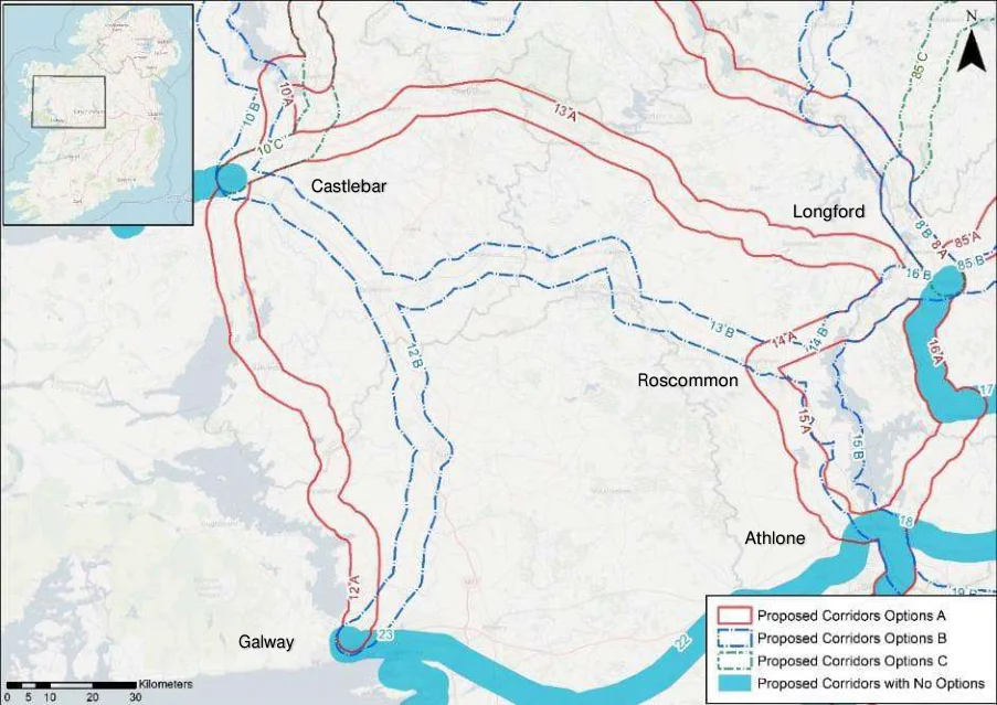
Figure from page 148
Castlebar
Galway
Figure E.3 : Corridor Options 12-15
National Cycle Network Plan – Appendices
Galway to Castlebar
Table E.6: Galway to Castlebar
| Corridor 12 - Galway to Castlebar | A | B | |||||||
|---|---|---|---|---|---|---|---|---|---|
| via N84 | via N17 (Galway / Castlebar) | ||||||||
| Demand | Commuting Trips | 0 | 0 | ||||||
| School Trips | -2 | 2 | |||||||
| Leisure Trips | -2 | 2 | |||||||
| Safety | Potential Safety Impacts | 1 | -1 | ||||||
| Integration | Integration with existing cycle infrastructure | -1 | 1 | ||||||
| Integration with planned cycling infrastructure | 0 | 0 | |||||||
| Integration with other existing alignments | -1 | 1 | |||||||
| Integration with transport modes | -1 | 1 | |||||||
| Integration with Tourist Attractions | -1 | 1 | |||||||
| Scenery and Route Attractiveness | 0 | 0 | |||||||
| Environment | Impact on sensitive areas | 0 | 0 | ||||||
| Accessibility & Social inclusion | Social Inclusion | 0 | 0 | ||||||
| Integration with Smaller Settlements | 0 | 0 | |||||||
| Gradients | 0 | 0 |
The Galway to Castlebar Corridor has two options, Option A via N84 and Option B via N17.
Option B is the preferred option due to its integration with more schools and sports facilities through Tuam and Claremorris and the existing Western Rail Corridor Greenway.
National Cycle Network Plan – Appendices
Castlebar to Longford
Table E.7: Castlebar to Longford
| Corridor 13 - Castlebar to Longford | A | B | |||||||
|---|---|---|---|---|---|---|---|---|---|
| via N5 | via N60 | ||||||||
| Demand | Commuting Trips | -2 | 2 | ||||||
| School Trips | -1 | 1 | |||||||
| Leisure Trips | -2 | 2 | |||||||
| Safety | Potential Safety Impacts | 1 | -1 | ||||||
| Integration | Integration with existing cycle infrastructure | 0 | 0 | ||||||
| Integration with planned cycling infrastructure | 0 | 0 | |||||||
| Integration with other existing alignments | 0 | 0 | |||||||
| Integration with transport modes | -2 | 2 | |||||||
| Integration with Tourist Attractions | -2 | 2 | |||||||
| Scenery and Route Attractiveness | 0 | 0 | |||||||
| Environment | Impact on sensitive areas | 0 | 0 | ||||||
| Accessibility & Social inclusion | Social Inclusion | 2 | -2 | ||||||
| Integration with Smaller Settlements | -2 | 2 | |||||||
| Gradients | 0 | 0 |
Compared to other corridors, the two options for the Castlebar to Longford Corridor cover large and distinct areas. Option A takes a northern route through the settlements of Strokestown, Ballaghaderreen, Charlestown and Swinford (N5) while Option B takes a southern route through Roscommon, Castlerea, Ballyhaunis and Claremorris (N60).
Option B is the preferred corridor due to its integration with tourist attractions and transport hubs.
Roscommon to Longford
Table E.8: Roscommon to Longford
| Corridor 14 - Roscommon to Longford | A | B | |||||||
|---|---|---|---|---|---|---|---|---|---|
| via N60 | southern option | ||||||||
| Demand | Commuting Trips | 0 | 0 | ||||||
| School Trips | 0 | 0 | |||||||
| Leisure Trips | 0 | 0 | |||||||
| Safety | Potential Safety Impacts | -1 | 1 | ||||||
| Integration | Integration with existing cycle infrastructure | 0 | 0 | ||||||
| Integration with planned cycling infrastructure | -2 | 2 | |||||||
| Integration with other existing alignments | 0 | 0 | |||||||
| Integration with transport modes | 0 | 0 | |||||||
| Integration with Tourist Attractions | 0 | 0 | |||||||
| Scenery and Route Attractiveness | -2 | 2 | |||||||
| Environment | Impact on sensitive areas | 1 | -1 | ||||||
| Accessibility & Social inclusion | Social Inclusion | 1 | -1 | ||||||
| Integration with Smaller Settlements | 0 | 0 | |||||||
| Gradients | 0 | 0 |
The Roscommon to Longford Corridor has two options. Option A via N60 and Option B which extends south alongside Lough Ree.
Option B is the preferred option due to its scenery and the planned Lough Ree Greenway.
National Cycle Network Plan – Appendices
Roscommon to Athlone
Table E.9: Roscommon to Athlone
| Corridor 15 - Roscommon to Athlone | A | B | |||||||
|---|---|---|---|---|---|---|---|---|---|
| west of N61 | east of N61 | ||||||||
| Demand | Commuting Trips | 0 | 0 | ||||||
| School Trips | 0 | 0 | |||||||
| Leisure Trips | -1 | 1 | |||||||
| Safety | Potential Safety Impacts | -1 | 1 | ||||||
| Integration | Integration with existing cycle infrastructure | 0 | 0 | ||||||
| Integration with planned cycling infrastructure | -2 | 2 | |||||||
| Integration with other existing alignments | 0 | 0 | |||||||
| Integration with transport modes | 0 | 0 | |||||||
| Integration with Tourist Attractions | -1 | 1 | |||||||
| Scenery and Route Attractiveness | -2 | 2 | |||||||
| Environment | Impact on sensitive areas | -1 | 1 | ||||||
| Accessibility & Social inclusion | Social Inclusion | -1 | 1 | ||||||
| Integration with Smaller Settlements | 0 | 0 | |||||||
| Gradients | 0 | 0 |
The Roscommon to Athlone Corridor has two options. Option A lies west of the N61 while Option B lies east of the N61 alongside Lough Ree.
Option B is the preferred option due to its scenery and the planned Lough Ree Greenway - Athlone to Ballyleague / Lanesborough.
National Cycle Network Plan – Appendices
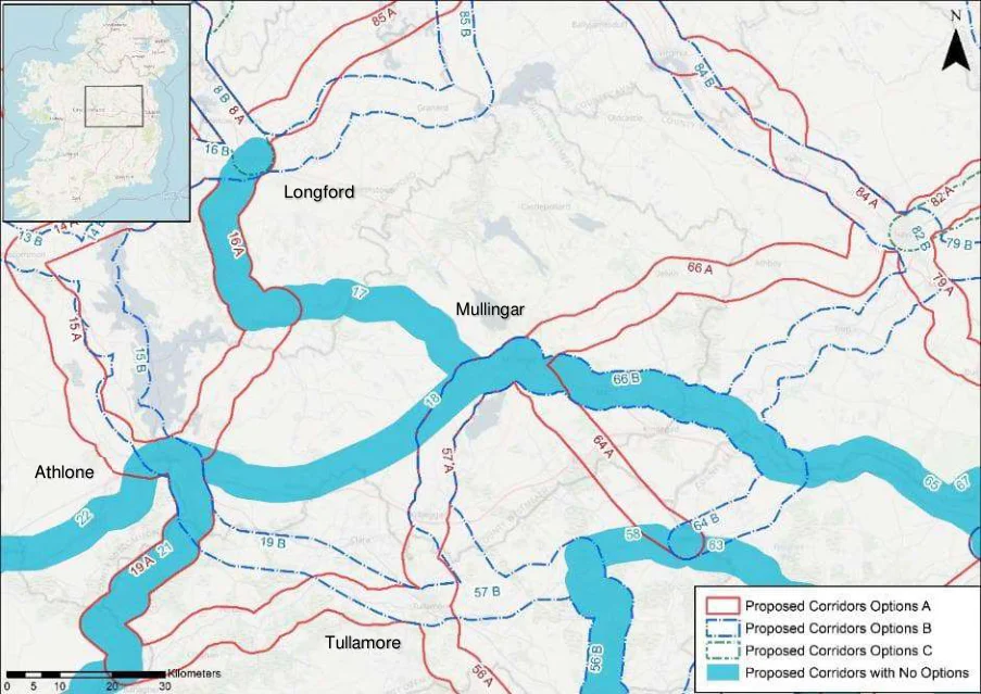
Figure from page 152
Longford
Athlone
Tullamore
Figure E.4 : Corridor Options 16-18
Athlone to Longford
Table E.10: Athlone to Longford
| Corridor 16 - Athlone to Longford | A | B | |||||||
|---|---|---|---|---|---|---|---|---|---|
| east of Lough Ree | west of Lough Ree | ||||||||
| Demand | Commuting Trips | 0 | 0 | ||||||
| School Trips | 2 | -2 | |||||||
| Leisure Trips | -1 | 1 | |||||||
| Safety | Potential Safety Impacts | -1 | 1 | ||||||
| Integration | Integration with existing cycle infrastructure | 2 | -2 | ||||||
| Integration with planned cycling infrastructure | -2 | 2 | |||||||
| Integration with other existing alignments | 0 | 0 | |||||||
| Integration with transport modes | 0 | 0 | |||||||
| Integration with Tourist Attractions | 0 | 0 | |||||||
| Scenery and Route Attractiveness | -2 | 2 | |||||||
| Environment | Impact on sensitive areas | 0 | 0 | ||||||
| Accessibility & Social inclusion | Social Inclusion | 0 | 0 | ||||||
| Integration with Smaller Settlements | 0 | 0 | |||||||
| Gradients | 0 | 0 |
The Athlone to Longford Corridor has two options, Option A, East of Lough Ree and Option B, West of Lough Ree.
Option B is the preferred corridor due to its scenery and integration with the Royal Canal Greenway.
National Cycle Network Plan – Appendices
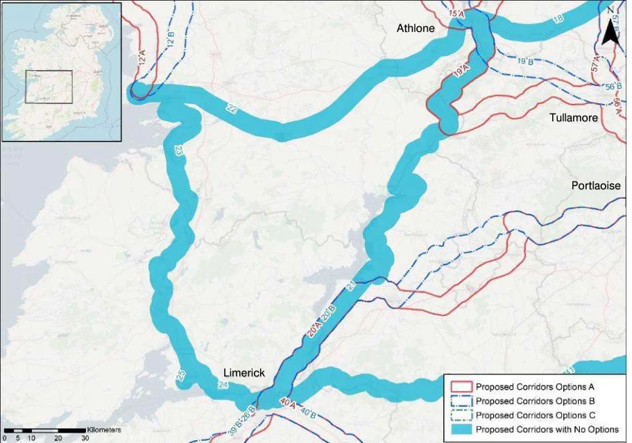
Figure from page 153
Figure E.5: Corridor Options 19-25
Athlone to Tullamore
Table E.11: Athlone to Tullamore
| Corridor 19 - Athlone to Tullamore | A | B | |||||||
|---|---|---|---|---|---|---|---|---|---|
| via Grand Canal | Northern Option | ||||||||
| Demand | Commuting Trips | 2 | -2 | ||||||
| School Trips | 1 | -1 | |||||||
| Leisure Trips | 0 | 0 | |||||||
| Safety | Potential Safety Impacts | 1 | -1 | ||||||
| Integration | Integration with existing cycle infrastructure | 2 | -2 | ||||||
| Integration with planned cycling infrastructure | 2 | -2 | |||||||
| Integration with other existing alignments | 0 | 0 | |||||||
| Integration with transport modes | 0 | 0 | |||||||
| Integration with Tourist Attractions | 0 | 0 | |||||||
| Scenery and Route Attractiveness | 2 | -2 | |||||||
| Environment | Impact on sensitive areas | -2 | 2 | ||||||
| Accessibility & Social inclusion | Social Inclusion | 0 | 0 | ||||||
| Integration with Smaller Settlements | 2 | -2 | |||||||
| Gradients | 0 | 0 |
Athlone to Tullamore has two options. Option A via the Royal Canal and Option B a more northern option.
Option A is the preferred corridor due to its integration with the Grand Canal greenway and further planned greenway infrastructure along its corridor.
National Cycle Network Plan – Appendices
Limerick to Portlaoise
Table E.12: Limerick to Portlaoise
| Corridor 20 - Limerick to Portlaoise | A | B | |||||||
|---|---|---|---|---|---|---|---|---|---|
| via Roscrea | via Cloughjordan | ||||||||
| Demand | Commuting Trips | -1 | 1 | ||||||
| School Trips | 2 | -2 | |||||||
| Leisure Trips | 1 | -1 | |||||||
| Safety | Potential Safety Impacts | 0 | 0 | ||||||
| Integration | Integration with existing cycle infrastructure | 0 | 0 | ||||||
| Integration with planned cycling infrastructure | 0 | 0 | |||||||
| Integration with other existing alignments | 0 | 0 | |||||||
| Integration with transport modes | 0 | 0 | |||||||
| Integration with Tourist Attractions | 0 | 0 | |||||||
| Scenery and Route Attractiveness | 0 | 0 | |||||||
| Environment | Impact on sensitive areas | 0 | 0 | ||||||
| Accessibility & Social inclusion | Social Inclusion | 0 | 0 | ||||||
| Integration with Smaller Settlements | -1 | 1 | |||||||
| Gradients | 0 | 0 |
The Limerick to Portlaoise Corridor has two options. Option A via Roscrea and Option B via Cloughjordan.
Option A is the preferred corridor due to serving more schools and leisure facilities through Roscrea.
National Cycle Network Plan – Appendices
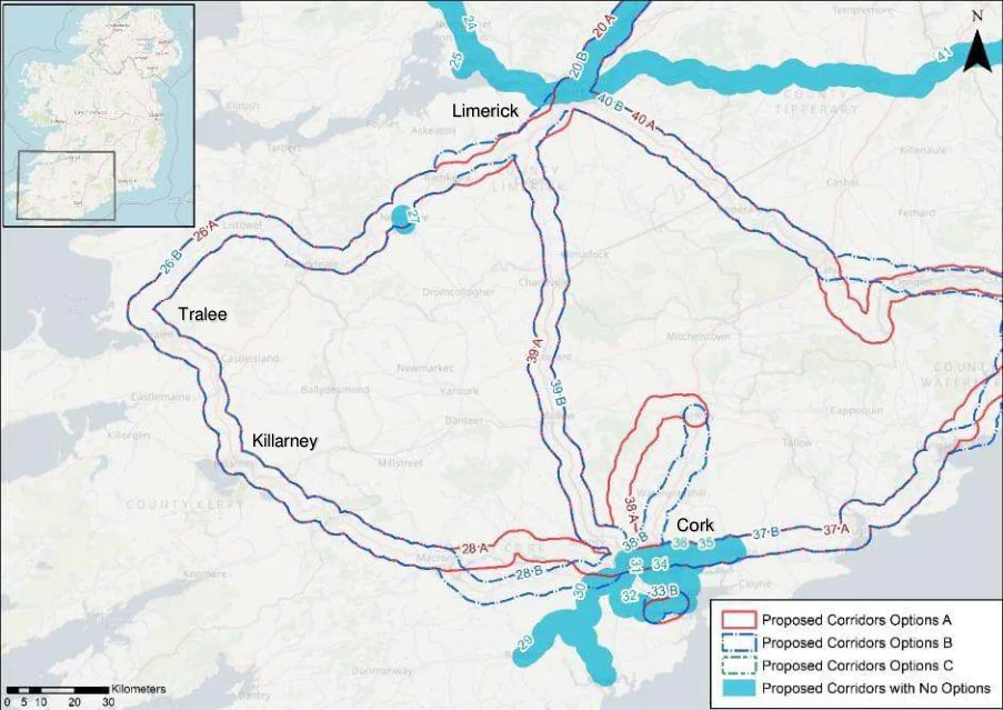
Figure from page 155
Tralee
Killarney
Figure E.6: Corridor Options 26-28
Tralee to Limerick
Table E.13: Tralee to Limerick
| Corridor 26 - Tralee to Limerick | A | B | |||||||
|---|---|---|---|---|---|---|---|---|---|
| via Adare | north of N21 | ||||||||
| Demand | Commuting Trips | -1 | 1 | ||||||
| School Trips | 0 | 0 | |||||||
| Leisure Trips | 0 | 0 | |||||||
| Safety | Potential Safety Impacts | -1 | 1 | ||||||
| Integration | Integration with existing cycle infrastructure | 0 | 0 | ||||||
| Integration with planned cycling infrastructure | 0 | 0 | |||||||
| Integration with other existing alignments | -2 | 2 | |||||||
| Integration with transport modes | 0 | 0 | |||||||
| Integration with Tourist Attractions | 0 | 0 | |||||||
| Scenery and Route Attractiveness | -1 | 1 | |||||||
| Environment | Impact on sensitive areas | 0 | 0 | ||||||
| Accessibility & Social inclusion | Social Inclusion | 1 | -1 | ||||||
| Integration with Smaller Settlements | -1 | 1 | |||||||
| Gradients | 0 | 0 |
The Tralee to Limerick corridor has two options. Option A via Adare and Option B north of the N21.
Option B is the preferred corridor due its integration with other alignments.
National Cycle Network Plan – Appendices
Cork to Tralee via Killarney
Table E.14: Cork to Tralee via Killarney
| Corridor 28 - Cork to Tralee via Killarney | A | B | |||||||
|---|---|---|---|---|---|---|---|---|---|
| north of N22 | via N22 | ||||||||
| Demand | Commuting Trips | 1 | -1 | ||||||
| School Trips | -2 | 2 | |||||||
| Leisure Trips | 1 | -1 | |||||||
| Safety | Potential Safety Impacts | 0 | 0 | ||||||
| Integration | Integration with existing cycle infrastructure | 0 | 0 | ||||||
| Integration with planned cycling infrastructure | 0 | 0 | |||||||
| Integration with other existing alignments | -1 | 1 | |||||||
| Integration with transport modes | 0 | 0 | |||||||
| Integration with Tourist Attractions | 0 | 0 | |||||||
| Scenery and Route Attractiveness | 0 | 0 | |||||||
| Environment | Impact on sensitive areas | 0 | 0 | ||||||
| Accessibility & Social inclusion | Social Inclusion | 0 | 0 | ||||||
| Integration with Smaller Settlements | 1 | -1 | |||||||
| Gradients | 0 | 0 |
The only difference between the two options for the Cork to Tralee via Killarney Corridor is the split at Cork City and the rejoining of the options near Macroom.
Option B is the preferred option due to its integration with schools.
National Cycle Network Plan – Appendices
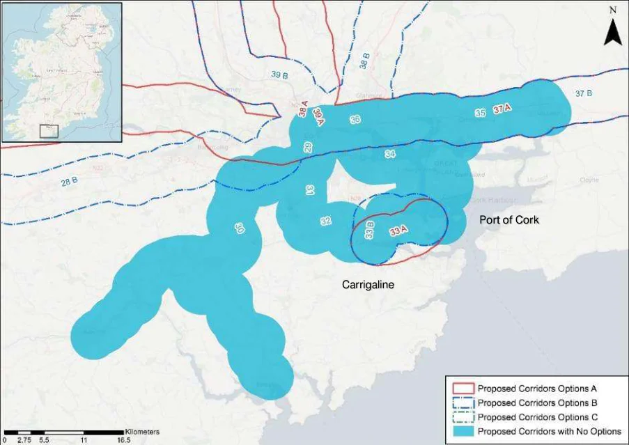
Figure from page 157
Figure E.7: Corridor Options 29-36
Port of Cork to Carrigaline
Table E.15: Port of Cork to Carrigaline
| Corridor 33 - Port of Cork to Carrigaline | A | B | |||||||
|---|---|---|---|---|---|---|---|---|---|
| via R613 | via Shanbally | ||||||||
| Demand | Commuting Trips | 0 | 0 | ||||||
| School Trips | -1 | 1 | |||||||
| Leisure Trips | -1 | 1 | |||||||
| Safety | Potential Safety Impacts | 1 | -1 | ||||||
| Integration | Integration with existing cycle infrastructure | -2 | 2 | ||||||
| Integration with planned cycling infrastructure | -2 | 2 | |||||||
| Integration with other existing alignments | -2 | 2 | |||||||
| Integration with Future Growth | 0 | 0 | |||||||
| Integration with Smaller Settlements | 0 | 0 | |||||||
| Tourism & Recreation | Integration with transport modes | -1 | 1 | ||||||
| Integration with Tourist Attractions | -1 | 1 | |||||||
| Scenery and Route Attractiveness | 0 | 0 | |||||||
| Environment | Impact on sensitive areas | 0 | 0 | ||||||
| Social Inclusion | Social Inclusion | 0 | 0 |
The Port of Cork to Carrigaline Corridor has two options. Option A via R613 and Option B via Shanbally.
Option B is the preferred option due to alignment with the greenway around Fernhill, as well as further planned greenways in the area.
National Cycle Network Plan – Appendices
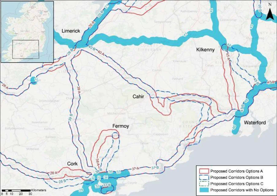
Figure from page 158
Limerick
Cork
Figure E.8: Corridor Options 35-40
Cork to Waterford
Table E.16: Cork to Waterford
| Corridor 37 - Cork to Waterford | A | B | |||||||
|---|---|---|---|---|---|---|---|---|---|
| via N25 | via R675 | ||||||||
| Demand | Commuting Trips | 0 | 0 | ||||||
| School Trips | 1 | -1 | |||||||
| Leisure Trips | 1 | -1 | |||||||
| Safety | Potential Safety Impacts | -1 | 1 | ||||||
| Integration | Integration with existing cycle infrastructure | -2 | 2 | ||||||
| Integration with planned cycling infrastructure | -2 | 2 | |||||||
| Integration with other existing alignments | -2 | 2 | |||||||
| Integration with transport modes | 0 | 0 | |||||||
| Integration with Tourist Attractions | 0 | 0 | |||||||
| Scenery and Route Attractiveness | -1 | 1 | |||||||
| Environment | Impact on sensitive areas | 1 | -1 | ||||||
| Accessibility & Social inclusion | Social Inclusion | 0 | 0 | ||||||
| Integration with Smaller Settlements | 0 | 0 | |||||||
| Gradients | 0 | 0 |
The Cork to Waterford Corridor Options only differ as they meet Dungarvan where they diverge before converging again before Kilmacthomas. Option A carries north of Dungarvan via N25 while Option B follows the coastal path via R675.
Option B is the preferred option due to integration with the existing “Deise” Greenway and the planned Fáilte Ireland Greenway.
National Cycle Network Plan – Appendices
Cork to Fermoy
Table E.17: Cork to Fermoy
| Corridor 38 - Cork to Fermoy | A | B | |||||||
|---|---|---|---|---|---|---|---|---|---|
| via Carrignavar | via Watergrasshill | ||||||||
| Demand | Commuting Trips | -1 | 1 | ||||||
| School Trips | -2 | 2 | |||||||
| Leisure Trips | -1 | 1 | |||||||
| Safety | Potential Safety Impacts | 1 | -1 | ||||||
| Integration | Integration with existing cycle infrastructure | 0 | 0 | ||||||
| Integration with planned cycling infrastructure | 1 | -1 | |||||||
| Integration with other existing alignments | -2 | 2 | |||||||
| Integration with transport modes | 0 | 0 | |||||||
| Integration with Tourist Attractions | 0 | 0 | |||||||
| Scenery and Route Attractiveness | 2 | -2 | |||||||
| Environment | Impact on sensitive areas | -1 | 1 | ||||||
| Accessibility & Social inclusion | Social Inclusion | 1 | -1 | ||||||
| Integration with Smaller Settlements | -1 | 1 | |||||||
| Gradients | -2 | 2 |
The Cork to Fermoy corridor has two options, Option A via Carrignavar and Option B via Watergrasshill.
Option B is the preferred option due to its integration with the R639 and the number of facilities along its corridor.
Limerick to Cork
Table E.18: Limerick to Cork
| Corridor 39 - Limerick to Cork | A | B | |||||||
|---|---|---|---|---|---|---|---|---|---|
| west of M7 | via R526 | ||||||||
| Demand | Commuting Trips | -1 | 1 | ||||||
| School Trips | 0 | 0 | |||||||
| Leisure Trips | 0 | 0 | |||||||
| Safety | Potential Safety Impacts | 0 | 0 | ||||||
| Integration | Integration with existing cycle infrastructure | -1 | 1 | ||||||
| Integration with planned cycling infrastructure | 2 | -2 | |||||||
| Integration with other existing alignments | 2 | -2 | |||||||
| Integration with transport modes | 0 | 0 | |||||||
| Integration with Tourist Attractions | 1 | -1 | |||||||
| Scenery and Route Attractiveness | 0 | 0 | |||||||
| Environment | Impact on sensitive areas | 0 | 0 | ||||||
| Accessibility & Social inclusion | Social Inclusion | 1 | -1 | ||||||
| Integration with Smaller Settlements | -1 | 1 | |||||||
| Gradients | 0 | 0 |
The Limerick to Cork Corridor has two options, Option A west of the M7 and Option B via R526.
Option A is the preferred option due to The Great Southern Trail Greenway planned along its route.
National Cycle Network Plan – Appendices
Limerick to Waterford via Cahir
Table E.19: Limerick to Waterford via Cahir
| Corridor 40 - Limerick to Waterford via Cahir | A | B | |||||||
|---|---|---|---|---|---|---|---|---|---|
| via Carrick on Suir | via R670 | ||||||||
| Demand | Commuting Trips | 1 | -1 | ||||||
| School Trips | 2 | -2 | |||||||
| Leisure Trips | 1 | -1 | |||||||
| Safety | Potential Safety Impacts | -1 | 1 | ||||||
| Integration | Integration with existing cycle infrastructure | -2 | 2 | ||||||
| Integration with planned cycling infrastructure | 2 | -2 | |||||||
| Integration with other existing alignments | 2 | -2 | |||||||
| Integration with transport modes | 0 | 0 | |||||||
| Integration with Tourist Attractions | 0 | 0 | |||||||
| Scenery and Route Attractiveness | 1 | -1 | |||||||
| Environment | Impact on sensitive areas | -2 | 2 | ||||||
| Accessibility & Social inclusion | Social Inclusion | 0 | 0 | ||||||
| Integration with Smaller Settlements | 1 | -1 | |||||||
| Gradients | 0 | 0 |
The Limerick to Waterford has two options, Option A via Carrick-on-Suir while Option B is via N24.
Option A is the preferred option due to its integration with a planned greenway along its corridor.
National Cycle Network Plan – Appendices
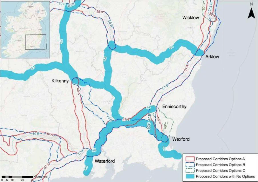
Figure from page 161
Kilkenny
Figure E.9: Corridor Options 43-54
Kilkenny to Waterford
Table E.20: Kilkenny to Waterford
| Corridor 45 - Kilkenny to Waterford | A | B | |||||||
|---|---|---|---|---|---|---|---|---|---|
| via N10 and R713 | via New Ross | ||||||||
| Demand | Commuting Trips | -1 | 1 | ||||||
| School Trips | -1 | 1 | |||||||
| Leisure Trips | -1 | 1 | |||||||
| Safety | Potential Safety Impacts | -1 | 1 | ||||||
| Integration | Integration with existing cycle infrastructure | 0 | 0 | ||||||
| Integration with planned cycling infrastructure | 0 | 0 | |||||||
| Integration with other existing alignments | -2 | 2 | |||||||
| Integration with transport modes | -1 | 1 | |||||||
| Integration with Tourist Attractions | -1 | 1 | |||||||
| Scenery and Route Attractiveness | -1 | 1 | |||||||
| Environment | Impact on sensitive areas | 0 | 0 | ||||||
| Accessibility & | Social Inclusion | 0 | 0 | ||||||
| Social | Integration with Smaller Settlements | -1 | 1 | ||||||
| inclusion | Gradients | 0 | 0 |
The Kilkenny to Waterford Corridor has two options. Option A via N10 and R713 and Option B via New Ross.
Option A is the preferred option due to its integration with the existing alignment on the New Ross Branch historical railway line which used to be the old Waterford line.
National Cycle Network Plan – Appendices
Enniscorthy to Waterford
Table E.21: Enniscorthy to Waterford
| Corridor 47 - Enniscorthy to Waterford | A | B | |||||||
|---|---|---|---|---|---|---|---|---|---|
| via N30 | via Ballywilliam | ||||||||
| Demand | Demand for Commuting Trips | -1 | 1 | ||||||
| School Trips | 0 | 0 | |||||||
| Leisure Trips | 0 | 0 | |||||||
| Safety | Potential Safety Impacts | -1 | 1 | ||||||
| Integration | Integration with existing cycle infrastructure | 0 | 0 | ||||||
| Integration with planned cycling infrastructure | 0 | 0 | |||||||
| Integration with other existing alignments | -2 | 2 | |||||||
| Integration with transport modes | 0 | 0 | |||||||
| Integration with Tourist Attractions | 0 | 0 | |||||||
| Scenery and Route Attractiveness | -1 | 1 | |||||||
| Environment | Impact on sensitive areas | 0 | 0 | ||||||
| Accessibility & Social inclusion | Social Inclusion | 0 | 0 | ||||||
| Integration with Smaller Settlements | -1 | 1 | |||||||
| Gradients | 0 | 0 |
The Enniscorthy to Waterford Corridor has two options, Option A via N30 and Option B via Ballywilliam.
Option B is the more preferred corridor due to its integration with more smaller settlements.
Enniscorthy to Wexford
Table E.22: Enniscorthy to Wexford
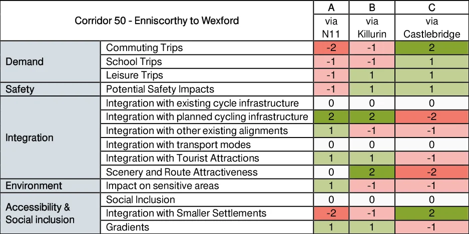
Figure from page 162
National Cycle Network Plan – Appendices
The Enniscorthy to Wexford Corridor has three options. Option A runs alongside the River Slaney and the N11, Option B follows a more westerly path via Killurin and crosses the River Slaney at Cornwall whereas Option C takes a steeper route via Castlebridge.
Option B is the preferred option due to integration with the Wexford to Waterford Corridor of the NCN and therefore also aligned with proposed infrastructure of the same project.
Enniscorthy to Wicklow via Arklow
Table E.23: Enniscorthy to Wicklow via Arklow
| Corridor 51 - Enniscorthy to Wicklow via Arklow | A | B | |||||||
|---|---|---|---|---|---|---|---|---|---|
| via R750 | via coastline (Enniscorthy / Wicklow) | ||||||||
| Demand | Commuting Trips | 1 | -1 | ||||||
| School Trips | 0 | 0 | |||||||
| Leisure Trips | -1 | 1 | |||||||
| Safety | Potential Safety Impacts | -1 | 1 | ||||||
| Integration | Integration with existing cycle infrastructure | 0 | 0 | ||||||
| Integration with planned cycling infrastructure | 2 | -2 | |||||||
| Integration with other existing alignments | 0 | 0 | |||||||
| Integration with transport modes | 0 | 0 | |||||||
| Integration with Tourist Attractions | 0 | 0 | |||||||
| Scenery and Route Attractiveness | -1 | 1 | |||||||
| Environment | Impact on sensitive areas | 2 | -2 | ||||||
| Accessibility & | Social Inclusion | 0 | 0 | ||||||
| Social | Integration with Smaller Settlements | 1 | -1 | ||||||
| inclusion | Gradients | 0 | 0 |
Option A and Option B are the same except for the segment between Wicklow and Arklow.
Option A is the preferred option due to integration with more populous settlements along its route and the Fáilte Ireland proposed a greenway along its route.
National Cycle Network Plan – Appendices
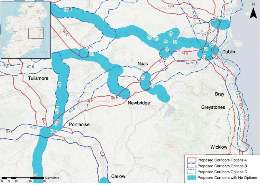
Figure from page 164
Tullamore
Portlaoise
Figure E.10: Corridor Options 52-56
Wicklow to Bray via Greystones
Table E.24: Wicklow to Bray via Greystones
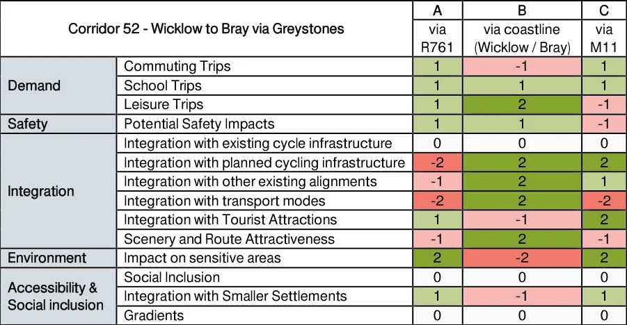
Figure from page 164
The Wicklow to Bray via Greystones corridor has three options, Option A via R761, Option B via the eastern coastline and Option C via M11.
Option B is the preferred option due to its coastal scenery and integration with a proposed greenway.
National Cycle Network Plan – Appendices
Bray to Dublin
Table E.25: Bray to Dublin
| Corridor 53 - Bray to Dublin | A | B | |||||||
|---|---|---|---|---|---|---|---|---|---|
| via Stillorgan | via Dun Laoghaire | ||||||||
| Demand | Commuting Trips | 0 | 0 | ||||||
| School Trips | 0 | 0 | |||||||
| Leisure Trips | -1 | 1 | |||||||
| Safety | Potential Safety Impacts | -1 | 1 | ||||||
| Integration | Integration with existing cycle infrastructure | -1 | 1 | ||||||
| Integration with planned cycling infrastructure | -1 | 1 | |||||||
| Integration with other existing alignments | -1 | 1 | |||||||
| Integration with transport modes | -2 | 2 | |||||||
| Integration with Tourist Attractions | 0 | 0 | |||||||
| Scenery and Route Attractiveness | -2 | 2 | |||||||
| Environment | Impact on sensitive areas | 2 | -2 | ||||||
| Accessibility & Social inclusion | Social Inclusion | 0 | 0 | ||||||
| Integration with Smaller Settlements | 0 | 0 | |||||||
| Gradients | 2 | -2 |
The Bray to Dublin corridor has two options, Option A via Stillorgan and Option B via Dun Laoghaire.
Option B is the more preferred option due to already comprehensive cycling infrastructure along the Dun Laoghaire to Blackrock route, planned dedicated cycling infrastructure in Sandymount on the coast road and the DART running along the corridor leading to possible mode change.
Portlaoise to Carlow
Table E.26: Portlaoise to Carlow
| Corridor 55 - Portlaoise to Carlow | A | B | |||||||
|---|---|---|---|---|---|---|---|---|---|
| via R445 | Via N80 | ||||||||
| Demand | Commuting Trips | 0 | 0 | ||||||
| School Trips | 0 | 0 | |||||||
| Leisure Trips | 0 | 0 | |||||||
| Safety | Potential Safety Impacts | 1 | -1 | ||||||
| Integration | Integration with existing cycle infrastructure | 0 | 0 | ||||||
| Integration with planned cycling infrastructure | 0 | 0 | |||||||
| Integration with other existing alignments | 0 | 0 | |||||||
| Integration with transport modes | 0 | 0 | |||||||
| Integration with Tourist Attractions | 0 | 0 | |||||||
| Scenery and Route Attractiveness | 1 | -1 | |||||||
| Environment | Impact on sensitive areas | 0 | 0 | ||||||
| Accessibility & Social inclusion | Social Inclusion | 0 | 0 | ||||||
| Integration with Smaller Settlements | 0 | 0 | |||||||
| Gradients | 0 | 0 |
The Portlaoise to Carlow Corridor has two options, Option A via R445 and Option B via N80.
National Cycle Network Plan – Appendices
Option A is the preferred corridor due to integrating with the R445 rather than the N80 in Option B.
Tullamore to Portlaoise
Table E.27: Tullamore to Portlaoise
| Corridor 56 - Tullamore to Portlaoise | A | B | |||||||
|---|---|---|---|---|---|---|---|---|---|
| via N80 | via Portarlington | ||||||||
| Demand | Commuting Trips | 2 | -2 | ||||||
| School Trips | -1 | 1 | |||||||
| Leisure Trips | -1 | 1 | |||||||
| Safety | Potential Safety Impacts | -1 | 1 | ||||||
| Integration | Integration with existing cycle infrastructure | -2 | 2 | ||||||
| Integration with planned cycling infrastructure | -2 | 2 | |||||||
| Integration with other existing alignments | 2 | -2 | |||||||
| Integration with transport modes | -1 | 1 | |||||||
| Integration with Tourist Attractions | -1 | 1 | |||||||
| Scenery and Route Attractiveness | 0 | 0 | |||||||
| Environment | Impact on sensitive areas | 0 | 0 | ||||||
| Accessibility | Social Inclusion | 1 | -1 | ||||||
| & Social | Integration with Smaller Settlements | 2 | -2 | ||||||
| inclusion | Gradients | 0 | 0 |
The Tullamore to Portlaoise Corridor has two options, Option A via N80 and Option B via Portarlington.
Option B is the preferred corridor due to aligning itself with the existing Grand Canal Greenway and the proposed Fáilte Ireland greenway along the rest of its route.
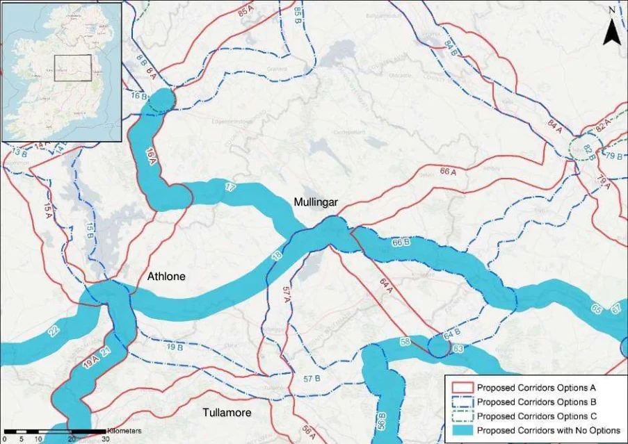
Figure from page 166
Athlone
Tullamore
Figure E.11 : Corridor Options 57
National Cycle Network Plan – Appendices
Mullingar to Tullamore
Table E.28: Mullingar to Tullamore
| Corridor 57 - Mullingar to Tullamore | A | B | |||||||
|---|---|---|---|---|---|---|---|---|---|
| via N52 | via Ballycommon | ||||||||
| Demand | Commuting Trips | -1 | 1 | ||||||
| School Trips | 0 | 0 | |||||||
| Leisure Trips | 0 | 0 | |||||||
| Safety | Potential Safety Impacts | 0 | 0 | ||||||
| Integration | Integration with existing cycle infrastructure | -2 | 2 | ||||||
| Integration with planned cycling infrastructure | 0 | 0 | |||||||
| Integration with other existing alignments | 0 | 0 | |||||||
| Integration with transport modes | 0 | 0 | |||||||
| Integration with Tourist Attractions | 0 | 0 | |||||||
| Scenery and Route Attractiveness | -1 | 1 | |||||||
| Environment | Impact on sensitive areas | 0 | 0 | ||||||
| Accessibility & Social inclusion | Social Inclusion | 0 | 0 | ||||||
| Integration with Smaller Settlements | -1 | 1 | |||||||
| Gradients | 0 | 0 |
The Mullingar to Tullamore Corridor has two options, Option A via N52 and Option B via Ballycommon.
Option B is the more preferred corridor due integration with the existing Grand Canal Greenway.
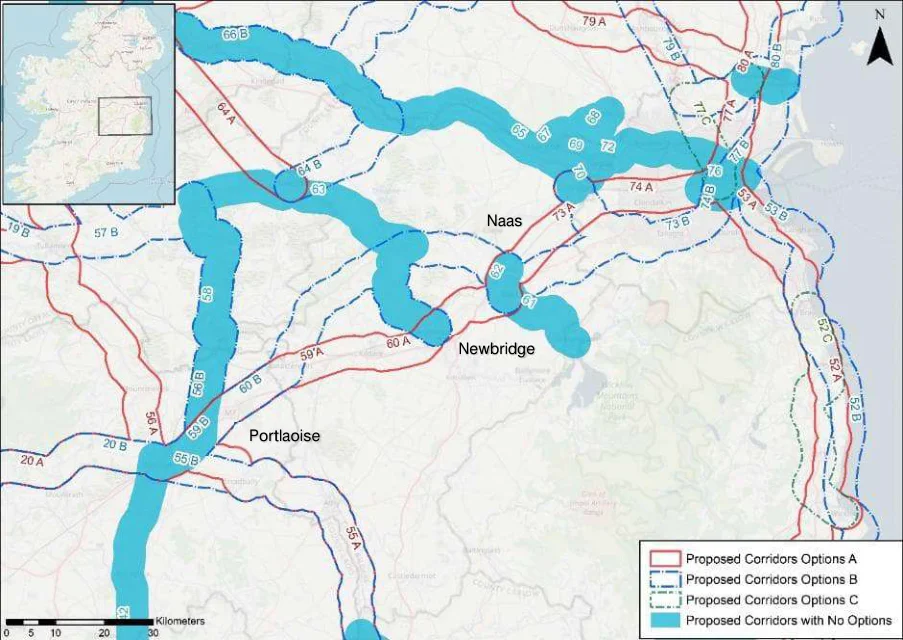
Figure from page 167
Portlaoise
Figure E.12 : Corridor Options 58-60
National Cycle Network Plan – Appendices
Portlaoise to Naas
Table E.29: Portlaoise to Naas
| Corridor 59 - Portlaoise to Naas | A | B | |||||||
|---|---|---|---|---|---|---|---|---|---|
| via Kildare & Newbridge | via Rathangan & Sallins | ||||||||
| Demand | Commuting Trips | -2 | 2 | ||||||
| School Trips | 1 | -1 | |||||||
| Leisure Trips | 1 | -1 | |||||||
| Safety | Potential Safety Impacts | -1 | 1 | ||||||
| Integration | Integration with existing cycle infrastructure | -2 | 2 | ||||||
| Integration with planned cycling infrastructure | 1 | -1 | |||||||
| Integration with other existing alignments | 0 | 0 | |||||||
| Integration with transport modes | 1 | -1 | |||||||
| Integration with Tourist Attractions | 1 | -1 | |||||||
| Scenery and Route Attractiveness | 0 | 0 | |||||||
| Environme | Impact on sensitive areas | -1 | 1 | ||||||
| nt | |||||||||
| Accessibili | Social Inclusion | -1 | 1 | ||||||
| ty & Social | Integration with Smaller Settlements | -2 | 2 | ||||||
| inclusion | Gradients | 0 | 0 |
The Portlaoise to Naas corridor has two options, Option A via Kildare & Newbridge and Option B via Rathangan & Sallins.
Option A is via Kildare which is a secondary node so it must be included in the network.
Portlaoise to Newbridge
Table E.30: Portlaoise to Newbridge
| Corridor 60 - Portlaoise to Newbridge | A | B | |||||||
|---|---|---|---|---|---|---|---|---|---|
| via Kildare | via Rathangan | ||||||||
| Demand | Commuting Trips | -2 | 2 | ||||||
| School Trips | 1 | -1 | |||||||
| Leisure Trips | 0 | 0 | |||||||
| Safety | Potential Safety Impacts | -1 | 1 | ||||||
| Integration | Integration with existing cycle infrastructure | 0 | 0 | ||||||
| Integration with planned cycling infrastructure | -2 | 2 | |||||||
| Integration with other existing alignments | 0 | 0 | |||||||
| Integration with transport modes | 1 | -1 | |||||||
| Integration with Tourist Attractions | 1 | -1 | |||||||
| Scenery and Route Attractiveness | -2 | 2 | |||||||
| Environment | Impact on sensitive areas | 0 | 0 | ||||||
| Accessibility & Social inclusion | Social Inclusion | 0 | 0 | ||||||
| Integration with Smaller Settlements | -2 | 2 | |||||||
| Gradients | 0 | 0 |
The Portlaoise to Newbridge Corridor has two options, Option A via Kildare and Option B via Rathangan.
Option A is via Kildare which is a secondary node so it must be included in the network.
National Cycle Network Plan – Appendices
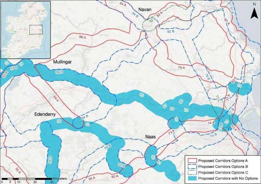
Figure from page 169
Mullingar
Edenderry
Figure E.13 : Corridor Options 61-64
Mullingar to Edenderry
Table E.31: Mullingar to Edenderry
| Corridor 64 - Mullingar to Edenderry | A | B | |||||||
|---|---|---|---|---|---|---|---|---|---|
| south of M4 | via Royal Canal Greenway | ||||||||
| Demand | Commuting Trips | -2 | 2 | ||||||
| School Trips | -2 | 2 | |||||||
| Leisure Trips | -2 | 2 | |||||||
| Safety | Potential Safety Impacts | -2 | 2 | ||||||
| Integration | Integration with existing cycle infrastructure | -2 | 2 | ||||||
| Integration with planned cycling infrastructure | -2 | 2 | |||||||
| Integration with other existing alignments | 0 | 0 | |||||||
| Integration with transport modes | 0 | 0 | |||||||
| Integration with Tourist Attractions | -1 | 1 | |||||||
| Scenery and Route Attractiveness | -2 | 2 | |||||||
| Environmen | Impact on sensitive areas | -1 | 1 | ||||||
| t | |||||||||
| Accessibilit | Social Inclusion | 2 | -2 | ||||||
| y & Social | Integration with Smaller Settlements | -2 | 2 | ||||||
| inclusion | Gradients | 0 | 0 |
The Mullingar to Edenderry corridor has two options, Option A south of M4 and Option B via Royal Greenway.
Option B is the preferred option due to its facilitation in the planned greenway link between the Royal and Grand Canal Greenways.
National Cycle Network Plan – Appendices
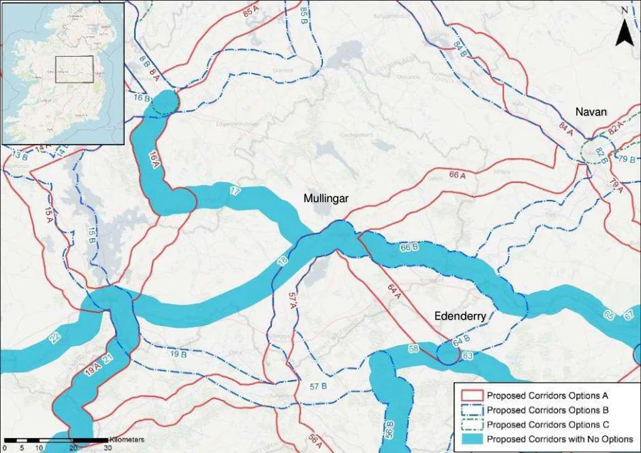
Figure from page 170
Figure E.14 : Corridor Options 65-66
Navan to Mullingar
Table E.32: Navan to Mullingar
| Corridor 66 - Navan to Mullingar | A | B | |||||
|---|---|---|---|---|---|---|---|
| via Delvin | via Trim | ||||||
| Demand | Commuting Trips | 1 | -1 | ||||
| School Trips | -1 | 1 | |||||
| Leisure Trips | -1 | 1 | |||||
| Safety | Potential Safety Impacts | -1 | 1 | ||||
| Integration | Integration with existing cycle infrastructure | -2 | 2 | ||||
| Integration with planned cycling infrastructure | -2 | 2 | |||||
| Integration with other existing alignments | 0 | 0 | |||||
| Integration with transport modes | 0 | 0 | |||||
| Integration with Tourist Attractions | -2 | 2 | |||||
| Scenery and Route Attractiveness | 0 | 0 | |||||
| Environment | Impact on sensitive areas | 2 | -2 | ||||
| Accessibility & Social inclusion | Social Inclusion | 1 | -1 | ||||
| Integration with Smaller Settlements | 1 | -1 | |||||
| Gradients | 0 | 0 |
National Cycle Network Plan – Appendices
The Navan to Mullingar Corridor has two options, Option A via Delvin and Option B via Trim.
Option B is the preferred option due to Fáilte Ireland’s proposed greenways and integration with the Royal Canal Greenway along its route.
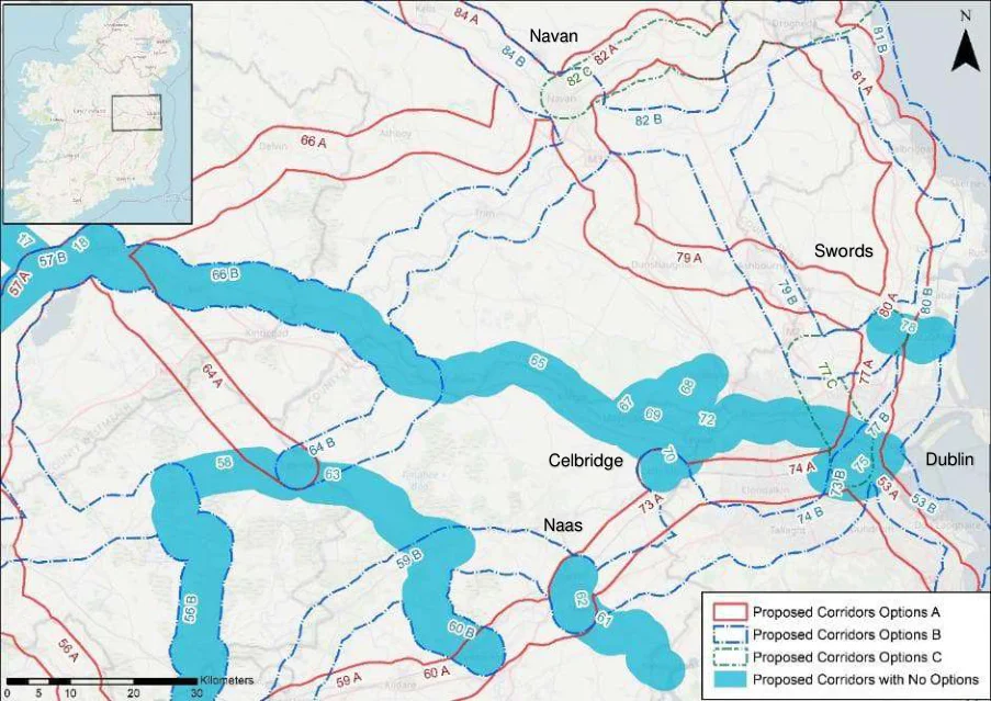
Figure from page 171
Figure E.15 : Corridor Options 73-74
Naas to Dublin
Table E.33: Naas to Dublin
| Corridor 73 - Naas to Dublin | A | B | |||||||
|---|---|---|---|---|---|---|---|---|---|
| via Clondalkin | via Tallaght | ||||||||
| Demand | Commuting Trips | -1 | 1 | ||||||
| School Trips | -1 | 1 | |||||||
| Leisure Trips | -1 | 1 | |||||||
| Safety | Potential Safety Impacts | -1 | 1 | ||||||
| Integration | Integration with existing cycle infrastructure | 2 | -2 | ||||||
| Integration with planned cycling infrastructure | 0 | 0 | |||||||
| Integration with other existing alignments | 2 | -2 | |||||||
| Integration with transport modes | 1 | -1 | |||||||
| Integration with Tourist Attractions | -1 | 1 | |||||||
| Scenery and Route Attractiveness | 2 | -2 | |||||||
| Environment | Impact on sensitive areas | 0 | 0 | ||||||
| Accessibility | Social Inclusion | 1 | -1 | ||||||
| & Social | Integration with Smaller Settlements | -1 | 1 | ||||||
| inclusion | Gradients | 0 | 0 |
The Naas to Dublin corridor has two options, Option A via Clondalkin and Option B via Tallaght.
Option A is the preferred corridor due to its integration with the Grand Canal Greenway.
National Cycle Network Plan – Appendices
Celbridge to Dublin
Table E.34: Celbridge to Dublin
| Corridor 74 - Celbridge to Dublin | A | B | |||||||
|---|---|---|---|---|---|---|---|---|---|
| via Grand Canal | via Tallaght | ||||||||
| Demand | Commuting Trips | -2 | 2 | ||||||
| School Trips | -2 | 2 | |||||||
| Leisure Trips | -1 | 1 | |||||||
| Safety | Potential Safety Impacts | 2 | -2 | ||||||
| Integration | Integration with existing cycle infrastructure | 2 | -2 | ||||||
| Integration with planned cycling infrastructure | 2 | -2 | |||||||
| Integration with other existing alignments | 0 | 0 | |||||||
| Integration with transport modes | 2 | -2 | |||||||
| Integration with Tourist Attractions | -1 | 1 | |||||||
| Scenery and Route Attractiveness | 2 | -2 | |||||||
| Environment | Impact on sensitive areas | 0 | 0 | ||||||
| Accessibility | Social Inclusion | 1 | -1 | ||||||
| & Social | Integration with Smaller Settlements | -2 | 2 | ||||||
| inclusion | Gradients | 0 | 0 |
The Celbridge to Dublin Corridor has two options, Option A via the Grand Canal and Option B via Tallaght.
Option A is the preferred corridor due to its integration with the Grand Canal Greenway.
National Cycle Network Plan – Appendices
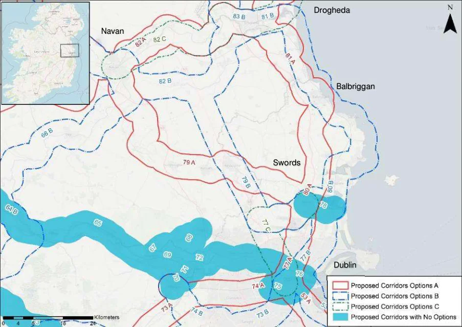
Figure from page 173
Navan
Figure E.16 : Corridor Options 76-82
Swords to Dublin
Table E.35: Swords to Dublin
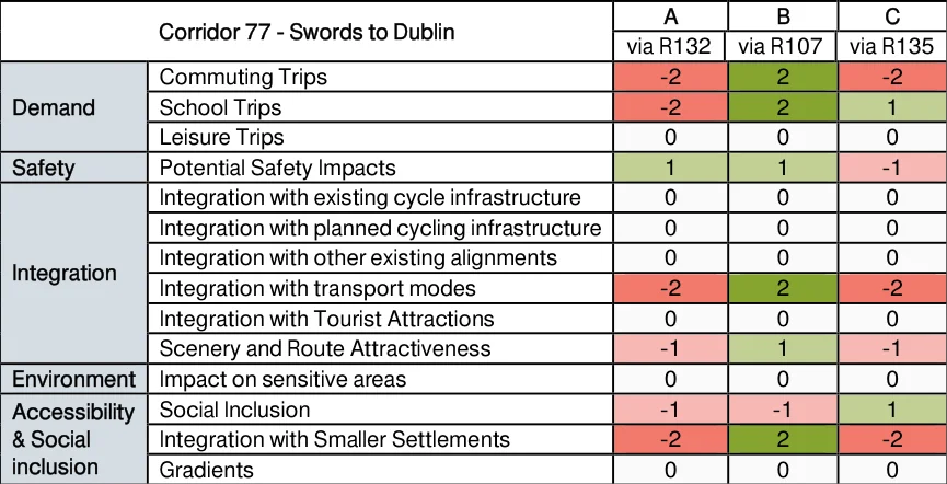
Figure from page 173
The Swords to Dublin corridor has three options, Option A via R132, Option B via R107 and Option C via R135.
Option B is the preferred corridor due to its integration with the DART line.
National Cycle Network Plan – Appendices
Navan to Swords
Table E.36: Navan to Swords
| Corridor 79 - Navan to Swords | A | B | |||||||
|---|---|---|---|---|---|---|---|---|---|
| via Ratoath | via N2 | ||||||||
| Demand | Commuting Trips | 2 | -2 | ||||||
| School Trips | 1 | -1 | |||||||
| Leisure Trips | 1 | -1 | |||||||
| Safety | Potential Safety Impacts | 0 | 0 | ||||||
| Integration | Integration with existing cycle infrastructure | 0 | 0 | ||||||
| Integration with planned cycling infrastructure | 0 | 0 | |||||||
| Integration with other existing alignments | 0 | 0 | |||||||
| Integration with transport modes | 0 | 0 | |||||||
| Integration with Tourist Attractions | -1 | 1 | |||||||
| Scenery and Route Attractiveness | 1 | -1 | |||||||
| Environment | Impact on sensitive areas | -1 | 1 | ||||||
| Accessibility & Social inclusion | Social Inclusion | 0 | 0 | ||||||
| Integration with Smaller Settlements | 2 | -2 | |||||||
| Gradients | 0 | 0 |
The Navan to Swords Corridor has two options, Option A via Ratoath and Option B via N2.
Option A is the preferred corridor due to serving local communities with more schools and sports facilities along its route.
Balbriggan to Swords
Table E.37: Balbriggan to Swords
| Corridor 80 - Balbriggan to Swords | A | B | |||||||
|---|---|---|---|---|---|---|---|---|---|
| via R132 | via coastline | ||||||||
| Demand | Commuting Trips | -2 | 2 | ||||||
| School Trips | -2 | 2 | |||||||
| Leisure Trips | -2 | 2 | |||||||
| Safety | Potential Safety Impacts | -2 | 2 | ||||||
| Integration | Integration with existing cycle infrastructure | 0 | 0 | ||||||
| Integration with planned cycling infrastructure | -1 | 1 | |||||||
| Integration with other existing alignments | 1 | -1 | |||||||
| Integration with transport modes | -2 | 2 | |||||||
| Integration with Tourist Attractions | -2 | 2 | |||||||
| Scenery and Route Attractiveness | -2 | 2 | |||||||
| Environment | Impact on sensitive areas | 2 | -2 | ||||||
| Accessibility & Social inclusion | Social Inclusion | 1 | -1 | ||||||
| Integration with Smaller Settlements | -2 | 2 | |||||||
| Gradients | 0 | 0 |
The Balbriggan to Swords Corridor has two options, Option A via R132 and Option B via the coastline.
Option B is the preferred option due to its higher population catchment and coastal route.
National Cycle Network Plan – Appendices
Drogheda to Balbriggan
Table E.38: Drogheda to Balbriggan
| Corridor 81 - Drogheda to Balbriggan | A | B | |||||||
|---|---|---|---|---|---|---|---|---|---|
| via R132 | via coastline | ||||||||
| Demand | Commuting Trips | 2 | -2 | ||||||
| School Trips | -1 | 1 | |||||||
| Leisure Trips | 1 | -1 | |||||||
| Safety | Potential Safety Impacts | -1 | 1 | ||||||
| Integration | Integration with existing cycle infrastructure | 0 | 0 | ||||||
| Integration with planned cycling infrastructure | -1 | 1 | |||||||
| Integration with other existing alignments | 1 | -1 | |||||||
| Integration with transport modes | 0 | 0 | |||||||
| Integration with Tourist Attractions | -1 | 1 | |||||||
| Scenery and Route Attractiveness | -2 | 2 | |||||||
| Environment | Impact on sensitive areas | 2 | -2 | ||||||
| Accessibility & Social inclusion | Social Inclusion | 0 | 0 | ||||||
| Integration with Smaller Settlements | 2 | -2 | |||||||
| Gradients | 0 | 0 |
The Drogheda to Balbriggan Corridor has two options, Option A via R132 and Option B via the coastline.
Option B is the preferred option due to its scenery via the eastern coastline.
Navan to Drogheda
Table E.39: Navan to Drogheda
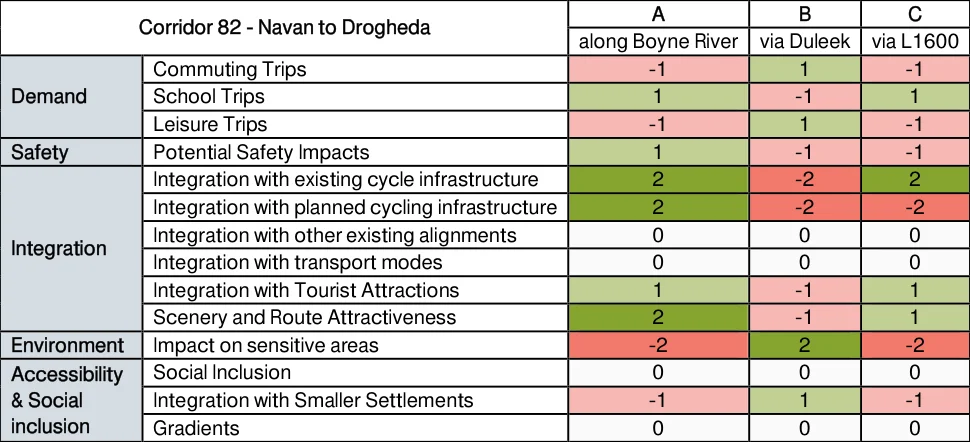
Figure from page 175
The Navan to Drogheda Corridor has three Options. Option A along Boyne River, Option B via Duleek and Option C via L1600.
Option A is the preferred option due to its integration with the existing greenway and planned TII Boyne Greenway and Navigation Scheme.
National Cycle Network Plan – Appendices
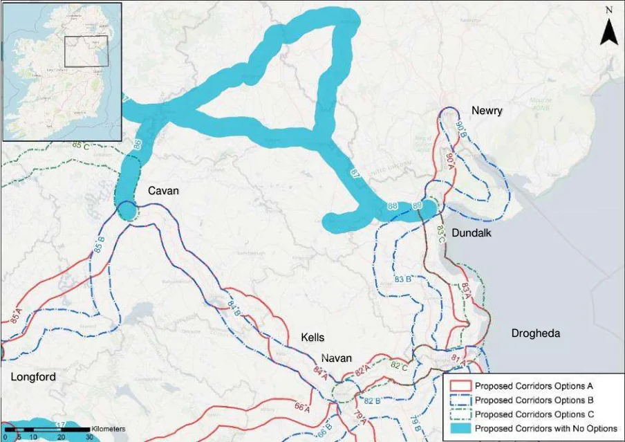
Figure from page 176
Cavan
Longford
Figure E.17 : Corridor Options 83-90
Dundalk to Drogheda
Table E.40: Dundalk to Drogheda
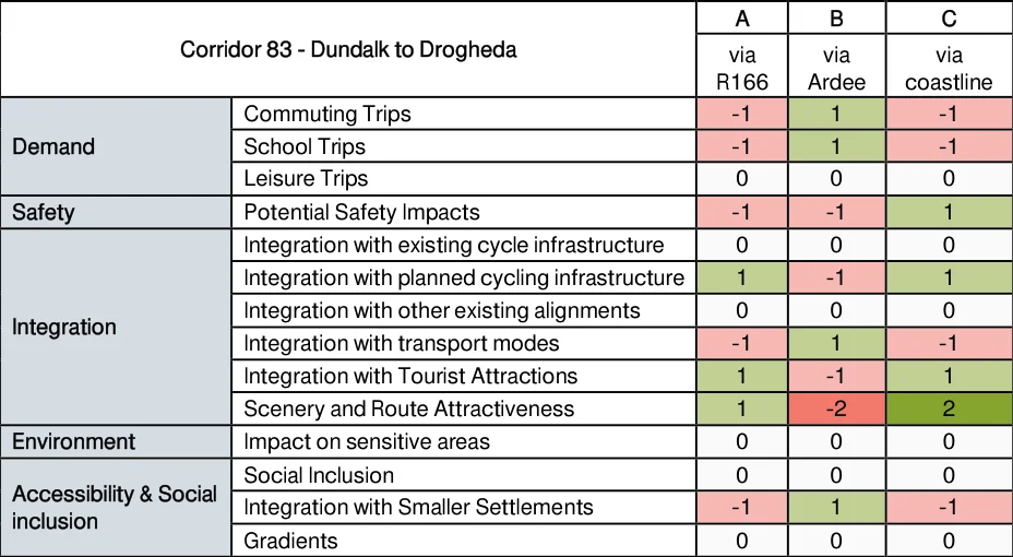
Figure from page 176
Option A and C are similar corridors along the east coast of Ireland whereas Option B is an inland corridor via Ardee.
Option C is the preferred option due to it passing through numerous beaches and coastal destinations along its cycleway.
National Cycle Network Plan – Appendices
Cavan to Navan via Kells
Table E.41: Cavan to Navan via Kells
| Corridor 84 - Cavan to Navan via Kells | A | B | |||||||
|---|---|---|---|---|---|---|---|---|---|
| via Mullagh | via N3 | ||||||||
| Demand | Commuting Trips | 2 | -2 | ||||||
| School Trips | 0 | 0 | |||||||
| Leisure Trips | 0 | 0 | |||||||
| Safety | Potential Safety Impacts | 1 | -1 | ||||||
| Integration | Integration with existing cycle infrastructure | 0 | 0 | ||||||
| Integration with planned cycling infrastructure | 0 | 0 | |||||||
| Integration with other existing alignments | -1 | 1 | |||||||
| Integration with transport modes | 0 | 0 | |||||||
| Integration with Tourist Attractions | 0 | 0 | |||||||
| Scenery and Route Attractiveness | 1 | -1 | |||||||
| Environment | Impact on sensitive areas | 1 | -1 | ||||||
| Accessibility & Social inclusion | Social Inclusion | 0 | 0 | ||||||
| Integration with Smaller Settlements | 2 | -2 | |||||||
| Gradients | 0 | 0 |
As the two options go through a similar area and only diverge for a short distance, there is relatively little difference between Options A, via Mullagh and B, via N3.
Option A is the preferred option due to its high population catchment along its route.
Longford to Cavan
Table E.42: Longford to Cavan
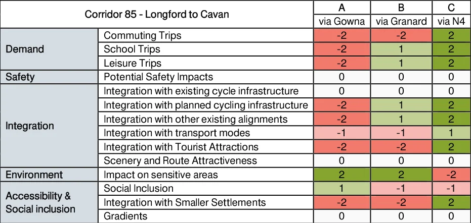
Figure from page 177
The Longford to Cavan Corridor has three options. Option A via Gowna, Option B via Granard and Option C via N4.
Option C is the preferred option due to its integration with local communities.
National Cycle Network Plan – Appendices
Newry to Dundalk
Table E.43: Newry to Dundalk
| Corridor 90 - Newry to Dundalk | A | B | |||||||
|---|---|---|---|---|---|---|---|---|---|
| via N1 | via Carlingford | ||||||||
| Demand | Commuting Trips | -2 | 2 | ||||||
| School Trips | -1 | 1 | |||||||
| Leisure Trips | -1 | 1 | |||||||
| Safety | Potential Safety Impacts | -1 | 1 | ||||||
| Integration | Integration with existing cycle infrastructure | -1 | 1 | ||||||
| Integration with planned cycling infrastructure | -2 | 2 | |||||||
| Integration with other existing alignments | 0 | 0 | |||||||
| Integration with transport modes | 1 | -1 | |||||||
| Integration with Tourist Attractions | -2 | 2 | |||||||
| Scenery and Route Attractiveness | -2 | 2 | |||||||
| Environment | Impact on sensitive areas | 2 | -2 | ||||||
| Accessibility & Social inclusion | Social Inclusion | 1 | -1 | ||||||
| Integration with Smaller Settlements | -2 | 2 | |||||||
| Gradients | 0 | 0 |
The Newry to Dundalk corridor has two options, Option A via N1 and Option B, via Carlingford.
Option B is the preferred option due to its existing alignments, scenery and route attractiveness.
Appendix F
SEA Screening Report
National Cycle Network Plan
Figure from page 180
Strategic Environmental Assessment (SEA) Screening Report
November 2021
National Cycle Network (NCN) Plan Strategic Environmental Assessment (SEA)
Screening Report
Quality information
Prepared by Checked by Verified by Approved by
Nick Chisholm-Batten Associate Director
Alastair Peattie Associate Director
Ben Green Associate Director
Ben Green Associate Director
Revision History
Revision Revision date Details Authorized Name Position
12th November Draft for client V2.0 2021 comment
12th November Nick Chisholm- 2021 Batten
Associate Director
Prepared for:
Transport Infrastructure Ireland
Prepared by:
AECOM Ireland Limited 4th Floor Adelphi Plaza Georges Street Upper Dun Laoghaire Co. Dublin A96 T927 Ireland T: +353 1 238 3100 aecom.com
© 2021 AECOM Ireland Limited. All Rights Reserved.
This document has been prepared by AECOM Ireland Limited (“AECOM”) for sole use of our client (the “Client”) in accordance with generally accepted consultancy principles, the budget for fees and the terms of reference agreed between AECOM and the Client. Any information provided by third parties and referred to herein has not been checked or verified by AECOM, unless otherwise expressly stated in the document. No third party may rely upon this document without the prior and express written agreement of AECOM.
AECOM
National Cycle Network (NCN) Plan Strategic Environmental Assessment (SEA)
Screening Report
Table of Contents
- Introduction … 1 Purpose of this SEA Screening Report … 1 Strategic Environmental Assessment and screening … 1 Structure of this SEA Screening Report… 1 2. Overview of the National Cycle Network Plan … 2 The National Cycle Network Plan … 2 Scope / geographical coverage of the NCN Plan … 2 Wider policy framework associated with the NCN Plan… 4 Key environmental constraints potentially affected by the NCN Plan … 4 3. Screening determination … 5 Screening criteria… 5 Screening assessment … 6 4. Summary and conclusions … 8 Legislative, regulatory or administrative provisions … 8 Setting the framework for plans and projects … 8 Conclusions … 9
AECOM
Strategic Environmental Assessment (SEA)
Screening Report
AECOM
National Cycle Network (NCN) Plan Strategic Environmental Assessment (SEA)
Screening Report
1. Introduction
Purpose of this SEA Screening Report
1.1 This Strategic Environmental Assessment (SEA) Screening Report has been prepared in relation to the National Cycle Network Plan by AECOM.
1.2 The purpose of the Screening Report is to set out a screening opinion with regards to whether a full SEA process is required to accompany the development of the National Cycle Network Plan. The screening opinion is to be presented to the statutory consultation bodies for SEA, the Environmental Protection Agency (EPA) and the Minister for the Environment, Climate and Communications for their comment.
Strategic Environmental Assessment and screening
1.3 Directive 2001/42/EC ‘The SEA Directive’ requires certain plans and programmes to undergo a SEA process. An SEA is the formal, systematic evaluation of the likely significant environmental effects of implementing a plan or programme, or variation to a plan or programme before a decision is made to adopt it.
1.4 The requirement for SEA in Ireland was introduced by European Communities (Environmental Assessment of Certain Plans and Programmes) Regulations 2004 (S.I. 435 of 2004) and The Planning and Development Strategic Environmental Assessment (SEA) Regulations 2004 (S.I. 436 of 2004). These Regulations have since been amended by the European Communities (Environmental Assessment of Certain Plans and Programmes) (Amendment) Regulations 2011 (S.I. No. 200 of 2011) and the Planning and Development (SEA) (Amendment) Regulations 2011 (S.I. No. 201 of 2011). These transposed the SEA Directive into Irish law.
1.5 Section 9 (4) of SI No. 435/2004 requires the screening of individual plans or programmes, based on the criteria in Schedule 1 of the SEA Regulations, which will support a determination as to whether or not significant effects on the environment would be likely to arise.
Structure of this SEA Screening Report
1.6 This Screening Report provides a screening opinion as to whether the National Cycle Network Plan is likely to lead to significant environment effects, and as such requires an SEA process. In this context it presents the following:
Details and context of the National Cycle Network Plan, including its scope and likely content, its relationship with national, regional and local plans and strategies and the key environmental constraints in the vicinity of the areas affected by the National Cycle Network Plan (Chapter 2)
A discussion of the potential significant environmental effects of the National Cycle Network Plan and their significance (Chapter 3); and
A summary of the screening opinion (Chapter 4).
AECOM
National Cycle Network (NCN) Plan Strategic Environmental Assessment (SEA)
Screening Report
2. Overview of the National Cycle Network Plan
The National Cycle Network Plan
2.1 Transport Infrastructure Ireland (TII) are currently working with key stakeholders to prepare a new National Cycle Network (NCN) Plan. This will map existing cycling infrastructure and identify gaps where future investment could be focused in order to establish a comprehensive and connected cycling network around Ireland.
2.2 The NCN Plan will focus on the inter-urban network with a priority on connectivity between urban areas of 5,000+ population, as well as to strategic destinations outside of urban areas (including transport hubs, centres of education, centres of employment, leisure destinations, and tourist destinations). It will aim to maximise the number of users and encourage modal shift. Where possible, the network will also optimise the potential for daily activities via active travel (e.g. school and work commutes) and integrate with existing and proposed active travel infrastructure.
2.3 The plan continues the previous work of TII’s National Cycle Network Scoping Study (2010) which proposed a high-level route corridor connecting urban centres of 10,000+ population. It also aligns with the ongoing work of the National Transport Authority (NTA) in developing urban cycle networks in areas of 5,000+ population. As such, the NCN Plan aims to compliment the various active travel infrastructure projects currently under development, and in planning, by providing a core spine that other networks and routes can connect to and expand upon.
2.4 The vision for the NCN Plan is as follows:
Develop a safe, connected, and inviting cycle network between urban areas and key destinations to achieve accessible, sustainable, and high-quality routes that will help to reduce the carbon impact of transport and promote a healthy and inclusive society.
Scope / geographical coverage of the NCN Plan
2.5 The NCN Plan will set out a proposed national cycle network connecting settlements with 5,000 inhabitants or more along identified corridors (Figure 2.1). It will also seek to connect key strategic destinations, (e.g. top tourist attractions, transport hubs, centres of education, centres of employment and others).
2.6 The likely corridors identified through the NCN Plan will mainly cover non-urban areas. This is given urban cycle networks are being covered by work currently being undertaken by the NTA.
2.7 Whilst the NCN Plan will not include specific or detailed routes, it will identify broad corridors through which interventions should be targeted. These identified corridors will be accompanied by recommendations relating to the level of infrastructure required along specific corridors or sections of corridor (e.g. segregated cycle path).
AECOM
National Cycle Network (NCN) Plan Strategic Environmental Assessment (SEA)
Screening Report
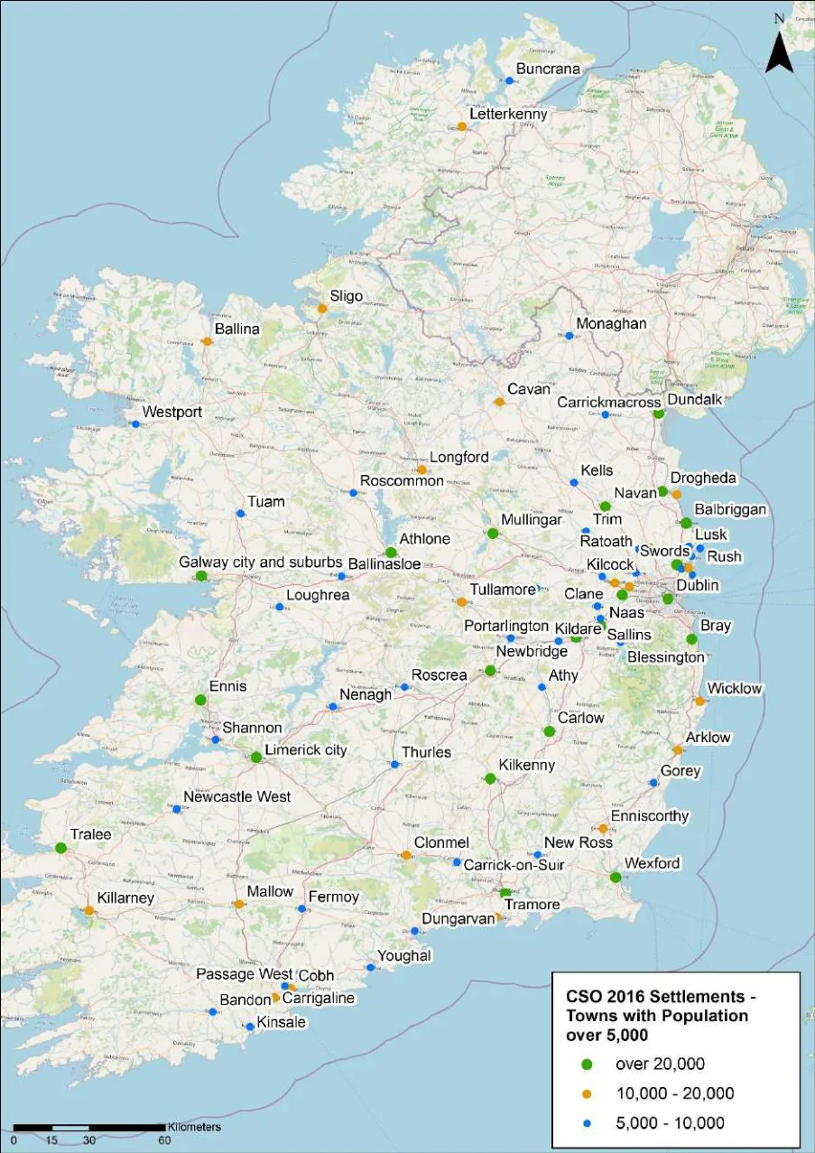
Figure 2.1: Settlements of over 5,000 inhabitants in the Republic of Ireland
AECOM
National Cycle Network (NCN) Plan Strategic Environmental Assessment (SEA)
Screening Report
Wider policy framework associated with the NCN Plan
2.8 The National Development Plan 2021-2030 highlights that the NCN Plan will provide a framework for a comprehensive and connecting cycling network and serve to inform future planning and project delivery decisions in relation to walking and cycling infrastructure. In this respect the National Development Plan highlights that it will be a valuable resource in relation to active travel connectivity around Ireland.
2.9 The NCN Plan is also being prepared in close conjunction with the NTA’s various initiatives on local cycle networks and in association with the provisions of the following:
National Planning Framework (NPF);
Common Appraisal Framework (CAF);
National Investment Framework for Transportation in Ireland (NIFTI);
Regional Spatial and Economic Strategies (RSES);
Road Safety Standards (RSS);
Safe Routes to School (SRTS); and
Public Spending Code (PSC).
2.10 The NCN Plan is not specifically required by legislative, regulatory or administrative provisions. It is however being progressed as a key component of the development of a National Cycle Network in Ireland.
Key environmental constraints potentially affected by the NCN Plan
Pages 105–187 · View in original PDF