4.1 and Table 4.2.
Table 4.1: Primary NCN Nodes
| Primary NCN | Basis for inclusion | ||
|---|---|---|---|
| Nodes | |||
| Armagh | NI connection point close to border (may depend on NI greenway strategy) | ||
| Athlone | >20,000 population | ||
| Balbriggan | >20,000 population | ||
| Ballina | >10,000 but less than 20,000 population but largest town in a sparsely populated region | ||
| Bray | >20,000 population | ||
| Carlow | >20,000 population | ||
| Castlebar | >10,000 but less than 20,000 population but largest town in a sparsely populated region | ||
| Cavan | >10,000 but less than 20,000 population but largest town in a sparsely populated region | ||
| Celbridge | >20,000 population | ||
| Cork | >20,000 population | ||
| Derry | NI connection point close to border (may depend on NI greenway strategy) | ||
| Drogheda | >20,000 population | ||
| Dublin | >20,000 population | ||
| Dundalk | >20,000 population | ||
| Ennis | >20,000 population | ||
| Enniskillen | NI connection point close to border (may depend on NI greenway strategy) | ||
| Galway | >20,000 population | ||
| Kilkenny | >20,000 population |
| Primary NCN | Basis for inclusion | ||
|---|---|---|---|
| Nodes | |||
| Letterkenny | >10,000 but less than 20,000 population but largest town in a sparsely populated region | ||
| Limerick | >20,000 population | ||
| Longford | >10,000 but less than 20,000 population but largest town in a sparsely populated region | ||
| Mullingar | >20,000 population | ||
| Naas | >20,000 population | ||
| Navan | >20,000 population | ||
| Newbridge | >20,000 population | ||
| Newry | NI connection point close to border (may depend on NI greenway strategy) | ||
| Omagh | NI connection point close to border (may depend on NI greenway strategy) | ||
| Portlaoise | >20,000 population | ||
| Sligo | >10,000 but less than 20,000 population but largest town in a sparsely populated region | ||
| Strabane | NI connection point close to border (may depend on NI greenway strategy) | ||
| Swords | >20,000 population | ||
| Tralee | >20,000 population | ||
| Waterford | >20,000 population | ||
| Wexford | >20,000 population | ||
| Wicklow | >10,000 but less than 20,000 population but largest town in a sparsely populated region |
National Cycle Network Plan
Table 4.2: Secondary NCN Nodes
| Secondary | Basis for inclusion | ||
|---|---|---|---|
| Nodes | |||
| Arklow | >10,000 population | ||
| Ashbourne | >10,000 population | ||
| Athlone station | Rail transport hub | ||
| Balbriggan station | Rail transport hub | ||
| Ballina Station | Rail transport hub | ||
| Bettystown | >10,000 population | ||
| Carlow station | Rail transport hub | ||
| Carrigaline | >10,000 population | ||
| Castlebar station | Rail transport hub | ||
| Ceannt Station Galway | Rail transport hub | ||
| Clonmel | >10,000 population | ||
| Cobh | >10,000 population | ||
| Connolly Station | Rail transport hub | ||
| Cork Airport | Transport hub | ||
| Dublin Airport | Transport hub | ||
| Dublin Port | Facilitates passenger ferries / cruise ships | ||
| Dun Laoghaire Harbour | Facilitates passenger ferries / cruise ships | ||
| Ennis station | Rail transport hub | ||
| Enniscorthy | >10,000 population | ||
| Galway Harbour | Facilitates passenger ferries / cruise ships | ||
| Greystones | >10,000 population | ||
| Heuston Station | Rail transport hub | ||
| Kent Station Cork | Rail transport hub | ||
| Killarney | >10,000 population | ||
| Leixlip | >10,000 population | ||
| Longford Station | Rail transport hub | ||
| MacBride Station Drogheda | Rail transport hub | ||
| MacDiarmada Station Sligo | Rail transport hub |
| Secondary | Basis for inclusion | ||
|---|---|---|---|
| Nodes | |||
| MacDonagh Station Kilkenny | Rail transport hub | ||
| Malahide | >10,000 population | ||
| Mallow | >10,000 population | ||
| Maynooth | >10,000 population | ||
| Middleton | >10,000 population | ||
| Monaghan | >5000 but less than 10,000 population but largest town in the region | ||
| Mullingar station | Rail transport hub | ||
| Sallins & Naas station | Rail transport hub | ||
| Newbridge station | Rail transport hub | ||
| O Hanrahan Station Wexford | Rail transport hub | ||
| Plunkett Station Waterford | Rail transport hub | ||
| Port of Cork | Facilitates passenger ferries / cruise ships | ||
| Port of Waterford | Facilitates passenger ferries / cruise ships | ||
| Portlaoise Station | Rail transport hub | ||
| Roscommon | >5,000 but less than 10,000 population but largest town in the region | ||
| Rosslare Europort | Facilitates passenger ferries / cruise ships | ||
| Shannon Airport | Transport hub | ||
| Skerries | >10,000 population | ||
| Thurles | >5,000 but less than 10,000 population but largest town in a sparsely populated region | ||
| Tramore | >10,000 population | ||
| Tullamore | >10,000 population | ||
| Westport Station | Rail transport hub | ||
| Wicklow station | Rail transport hub |
National Cycle Network Plan
Step 2 – Identify Connections
Connections between nodes were established and links connecting the Primary and Secondary Nodes were developed. These connected primary nodes to adjacent primary and secondary nodes, as well as secondary nodes to adjacent primary nodes (either directly or via another secondary node).
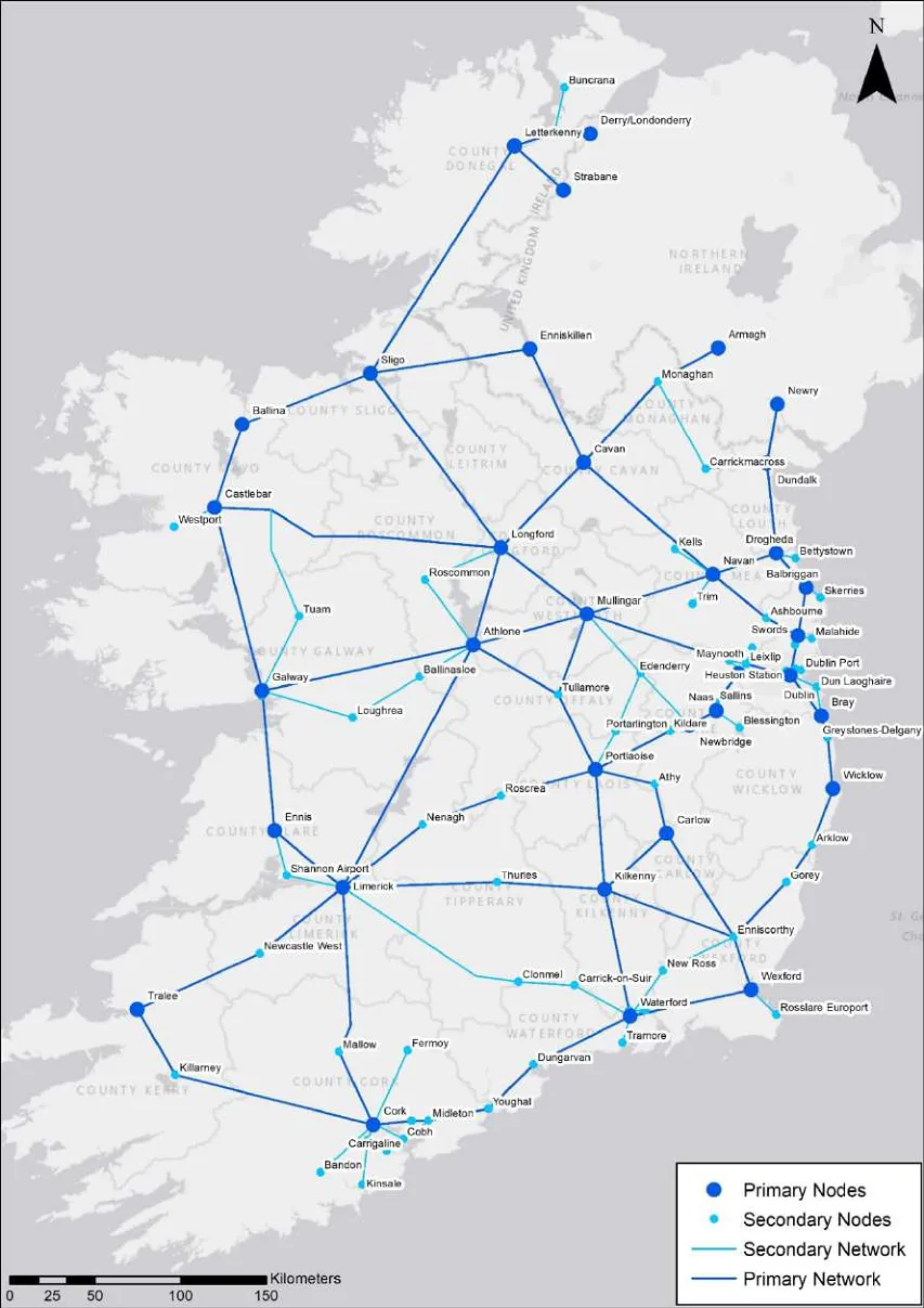
Figure 4.2: NCN Nodes and Links
National Cycle Network Plan
Step 3 – Stakeholder Workshop: Destinations & Links
Workshops were held with key stakeholders to discuss and agree the nodes included in the NCN, as well as the proposed links between nodes. Stakeholders included the Department of Transport, the NTA, the CCMA, Fáilte Ireland, Sport Ireland, Cyclist.ie.
The discussions primarily revolved around defining primary and secondary nodes, and the density of the resulting cycle network. Initially, a population threshold of 10,000 or more was proposed for settlements, but it was deemed insufficient to provide comprehensive coverage. After engaging with stakeholders, it was unanimously agreed to lower the threshold to settlements with a population greater than 5,000 people. Additionally, transportation hubs such as train stations, airports, and ferry / cruise ship ports were identified as key nodes. Smaller settlements and other significant destinations like educational centers, recreational spots, and tourist attractions were classified as other nodes. This approach was agreed as it would lead to a suitably dense national network.
Step 4 – Identify Corridors
Once the NCN primary and secondary nodes were determined, the Links from Stage 2 were refined to develop corridors and corridor options connecting primary and secondary nodes. The purpose of this stage was to refine these links and to develop a series of corridor options. Corridor options were indicative alternatives of how to connect the primary and secondary nodes and aim to provide connections to other nodes (e.g., smaller settlements) where appropriate. An example of the corridor development approach is illustrated in Figure 4.3.
The identification of corridor options factored in multiple data sets using the NCN GIS dashboard developed for this purpose and targeted the use of existing or planned cycling (and other linear) infrastructure whenever possible.
Corridors connect:
Primary nodes (●) and Secondary nodes (●) ─
Corridors aim to incorporate:
Tertiary nodes, i.e., smaller settlements (●), centres of education, centres of employment, ─ leisure destinations, and tourist destinations
Existing cycle networks / infrastructure (–,–,–) ─
Planned cycle networks / infrastructure (–,–) ─
─ Other existing or natural resources, e.g., disused railways (—)
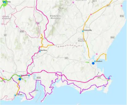
Figure 4.3: Example of Corridor Development — NCN GIS dashboard (left), proposed NCN corridor options (right)
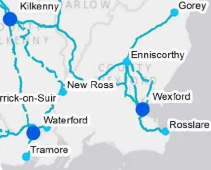
Figure 4.3: Example of Corridor Development — NCN GIS dashboard (left), proposed NCN corridor options (right)
National Cycle Network Plan
Where more than one potential corridor alignment existed for a given linkage between two nodes, possible corridor options were assessed as outlined in Step 5 to identify the best performing option for inclusion in the NCN. Identified corridors were approximately 4km wide and did not include any design information.
Step 5 – Corridor Options Assessment
Where multiple options for NCN corridors had been identified, the performance of each option was determined by consideration against a range of assessment criteria as described below. The assessment of corridor options against these criteria was informed by a series of specific data sets as summarised in Table 4.3. Full details of the assessment approach, results and a list of the preferred corridor options are provided in Appendix E.
Table 4.3: Assessment Framework Summary Table
| NCN Plan Objectives | NCN Assessment | Data Set | ||
|---|---|---|---|---|
| Criteria | ||||
| Increase the number of cycle trips by improving the provision of safe and attractive cycling infrastructure. Connect to strategic destinations outside of urban areas as appropriate (including centres of education, centres of employment, and leisure destinations). | Commuter Trips | Database of smaller settlements between the 1,000 and 5,000 population (Other Nodes) | ||
| School Trips | Data base of Primary and Secondary Schools - Developed by AECOM | |||
| Leisure Trips | Data base of leisure facilities – including sports clubs and off-road trails - Developed by AECOM | |||
| Promote the design of cycling infrastructure that meets safety requirements. Promote the design of cycling infrastructure that provides a safe and secure environment for all users. | Potential Safety Impacts | National Transport Models Road Network showing flows in the form of AADT, posted speed limits and average speeds. | ||
| Integrate with existing and proposed cycling infrastructure (including greenways, safe routes to schools, the EuroVelo network, Interreg projects), as appropriate Incorporate existing greenways, disused railways, canals, bypassed national roads, regional and local roads, long distance trails, as appropriate. Propose corridors to maximise the number of users. Future-proof cycle route capacity, taking account of population growth and additional demand from modal shift. Connect to strategic destinations outside of urban areas as appropriate (including centres of education, centres of employment, and leisure destinations). | Integration with Existing Cycle Infrastructure | Database of existing cycle infrastructure – including greenways, Blueway’s and Eurovelo routes – developed by AECOM | ||
| Integration with Planned Cycle Infrastructure | Database of proposed cycle infrastructure – including greenways, Blueway’s and Eurovelo routes – developed by AECOM | |||
| Integration with Existing Infrastructure | Database of disused railways developed by AECOM | |||
| Integration with transport modes | Database of train stations - Developed by AECOM | |||
| Integration with Tourist Attractions | Fáilte Ireland database of tourist attractions with visitor numbers <200k total visitors in 2019. | |||
| Scenery and Route Attractiveness | ESRI Basemap |
National Cycle Network Plan
| NCN Plan Objectives | NCN Assessment | Data Set | ||
|---|---|---|---|---|
| Criteria | ||||
| Enhance local environments and biodiversity where possible (e.g., pollinator plans, green corridors). Support the development of cycling and walking culture in Ireland. | Impact on sensitive areas | Database of Special Protection Areas, Special Areas of Conservations and Proposed National Heritage Areas / National Heritage Areas and architectural conservation areas – Developed by AECOM. | ||
| Connect to strategic destinations outside of urban areas (including transport hubs and tourist destinations), as appropriate. | Social Inclusion | Pobal deprivation index - Developed by AECOM | ||
| Integration with Smaller Settlements | Database of smaller settlements between the 1,000 and 5,000 population (Other Nodes) | |||
| Gradient | ESRI Contour Maps |
Strategic Environmental Assessment (SEA) and Appropriate Assessment (AA) were integral to the option selection process.
SEA is a systematic process for evaluating the environmental consequences of proposed plans or programmes to ensure environmental issues are fully integrated and addressed at the earliest appropriate stage of decision making, with a view to promoting sustainable development. The assessment identified and evaluated the likely significant effects of each potential corridor option on an established baseline. The results of this assessment, contained in the SEA Environmental Report (Appendix G), was integral to the identification of the preferred corridor options.
An AA is an assessment of the potential adverse effects of a plan or project (in combination with other plans or projects) on the Natura 2000 network of European sites, i.e. Special Areas of Conservation (SACs) and Special Protection Areas (SPAs). Appropriate Assessment was integral to corridor assessment because likely significant effects cannot be dismissed alone, except for corridors 11 (Westport to Castlebar), 26 (Newcastle West to Tralee / Limerick), 57 (Newbridge to Naas) and 68 (Naas to Dublin), which could be screened out of AA because there are no European sites within the 4km corridors. The AA concluded that the flexible nature of the proposed NCN corridors provides the ability for all final cycle routes to be designed in such a way as to minimise and potentially avoid impacts rendering them non-significant, so long as the mitigation measures and development process outlined in the NIS, and summarised in Section 7.6, are employed.
The Appropriate Assessment is provided as part of the Natura Impact Statement in Appendix I.
Step 6 – Stakeholder Workshop
Having successfully completed Step 5, a comprehensive network of individual corridors between NCN Nodes was identified. The proposed corridors were those that best served the needs of the local community , having the potential to provide for the highest number of cycling trips and aligning with the objectives of the NCN Plan.
The next step in the NCN development process was to hold a series of workshops to discuss the network and allow stakeholders raise any potential issues. Stakeholders included the Department of Transport, the NTA, the CCMA, Fáilte Ireland, Sport Ireland, Cycling Ireland, Cyclist.ie.
The discussions focused on the process used to develop the corridors and a review of the resulting network. The issue of network coverage on the west coast was again highlighted but reviewing the proposed NCN in the context of other existing and planned cycle infrastructure (i.e., EuroVelo routes and greenways) it was agreed that the coverage and density of the corridor options presented achieved the project objectives and provided the intended core network.
National Cycle Network Plan
Step 7 – Public Consultation
The emerging NCN network was presented for public consultation to solicit the public’s views and opinions on the identified nodes and corridors and gain valuable feedback. Many of the stakeholders involved in previous workshops also submitted detailed feedback on the proposed NCN.
Some of the main points raised by submissions received during the public consultation in relation to the proposed network included:
Expanding the network to include additional greenways and rural settlements.
Incorporating (and upgrading) existing (and proposed) cycle infrastructure where possible.
Integrating with local cycle networks and connect town centres.
Feedback from public consultation was incorporated during finalisation of the NCN Plan and is included in Appendix C of this report.

Figure from page 43
| Feedback on NCN Propo | ||

Figure from page 43
National Cycle Network Plan
Feedback on NCN Proposals
As outlined in Section 4, a five-week public consultation process was undertaken on the emerging NCN to determine the public view on the identified nodes and corridors. The overall sentiment of feedback received was supportive of the proposed NCN and the development of additional cycle infrastructure. The main points raised by the submissions received, which were used to finalise the proposed network, are outlined below.
5.1Safety
Safety was identified as a major concern, with specific mention of the need for segregated routes and the impact of vehicle volume and speed.
One major concern identified was the need for segregated routes. Respondents noted that separating different modes of transportation, such as cars, buses, and bicycles, can reduce the risk of collisions and improve overall safety.
Many respondents also highlighted that high volumes of traffic and high speeds can increase the risk of accidents, especially for vulnerable road users such as pedestrians and cyclists. It was suggested that measures such as reducing speed limits in areas with high pedestrian or cycle traffic or implementing traffic calming measures to slow down vehicles can help to improve safety.
5.2Incorporating and Upgrading Existing Cycle Infrastructure
Many survey respondents suggested incorporating and upgrading existing cycle infrastructure into the proposed NCN. This would be an efficient and cost-effective way to improve the NCN and connect key destinations. Respondents highlighted that many existing routes and infrastructure are underutilised and in need of repair. Incorporating such routes and upgrading existing infrastructure would make them more attractive and safer for people to use. Furthermore, it will support local communities and economies by attracting more people to the area.
5.3Leisure and Exercise Use of the NCN
The primary expected uses for the network were identified as leisure and exercise. Many respondents stated that they would use the NCN for recreational activities such as cycling with their family, going for a leisurely bike ride, or as a way to stay active and healthy. Additionally, there was enthusiasm about the opportunity to explore new areas and scenic routes through the use of the NCN. This highlights the importance of developing a network that not only provides safe and accessible transportation but also promotes healthy lifestyles and outdoor activities.
5.4Access and Segregation
The lack of access to the proposed network was cited as an issue, with many respondents indicating that the proposed routes did not pass near their geographic area. This highlights the need to ensure that the NCN is well connected to key destinations and areas of high population density and the wider networks. Additionally, non-segregated routes, where bicycles and motor vehicles share the same space, were also identified as a concern among respondents. Many respondents stated that they felt unsafe or uncomfortable cycling on routes shared with motor vehicles, leading them to avoid using such infrastructure. This highlights the importance of providing dedicated and separate infrastructure for bicycles where necessary to ensure the safety of the users.
5.5Greenways and Rural Settlements
Respondents suggested that the proposed NCN should be expanded to include additional national and regional greenways and rural settlements. It was suggested that the proposed network did not
National Cycle Network Plan
sufficiently cover these areas, and that including more greenways and rural settlements would allow for more opportunities for outdoor recreation and exploration. Greenways are typically multi-use paths that are set aside for pedestrian and bicycle use, often built along disused rail corridors, canal towpaths, rivervalleys and scenic routes. They provide a safe, car-free environment for people to walk, cycle and enjoy the natural environment. Rural settlements are typically found in the countryside and are small towns or villages that offer a unique opportunity for people to explore and experience the local culture and way of life.
Respondents also pointed out that including greenways and rural settlements in the NCN would provide more options for people to use the network for leisure, tourism and exercise. It would also support the local communities and economies by attracting more visitors. Therefore, the inclusion of greenways and rural settlements in the NCN would not only provides more opportunities for active transport but also promotes healthy lifestyles, outdoor activities and sustainable tourism.
5.6Local Network and Town Centre Integration
Respondents suggested integrating the NCN with local networks and connecting town centres for better connectivity, accessibility, and user-friendliness. This would also promote active transportation and sustainable tourism. Integrating the NCN with local networks would connect key destinations such as homes, workplaces, and local amenities to the NCN, making it more accessible to a wider range of users. Connecting town centres to the NCN would also make it easier for people to access the network and promote active transportation and sustainable tourism. Many town centres currently lack good connections to the NCN, making it difficult for people to access these areas by bicycle. By integrating the NCN with local networks and connecting town centres, the NCN would become more attractive and accessible to a wider range of users and would also contribute to the promotion of active transportation and sustainable tourism.
5.7Conclusion
The feedback received validated both the approach taken to developing the network and the proposed network. It also provided important input from both specific stakeholders and the general public which was incorporated into an updated version of the network, network design principles and monitoring framework. More detailed information on feedback to the NCN Plan can be found in Appendix C.

Figure from page 46
National Cycle Network
Figure from page 46
National Cycle Network Plan
National Cycle Network
6.1Overview
The final network after the consideration of the public consultation feedback is presented in Figure 6.1. The network is composed of 85 corridors across a network of approximately 3,500km in length and connects to over 200 settlements with a combined population of over 2.8million people5. With 80% of houses and 89% of jobs located within 5km of the network6 the network provides an excellent level of connectivity nationally.
Figure 6.2 shows the final NCN integrated with both existing and planned cycle networks and infrastructure including: planned national and regional greenways7, Eurovelo 1, Eurovelo 2 and Planned Northern Ireland greenways.
The current status of the network is as follows:
Existing infrastructure: Approximately 400km of the NCN is currently in use as existing greenways or other suitable cycle infrastructure.
Proposed / planned greenways: Approximately 950km of the NCN is currently included in the National and Regional Greenways Programme.
Remaining network: The remaining 2,150km of the NCN will require the provision of new infrastructure outside the national and regional Greenways Programme and associated funding.
Table 6.1: Length of NCN by Current Status
| Current Status | Approximate |
|---|---|
| Length | |
| (km) | |
| Existing infrastructure | 400 |
| Proposed / planned greenways | 950 |
| Remaining (i.e., neither existing cycle infrastructure nor proposed / planned greenway) | 2,150 |
| Total length | 3,500 |
5 Based 2016 Census 6 Based on GeoDirectory Q4 2021 and 2016 POWSCAR respectively 7 Note: Illustrated routes are indicative. Final Greenway routes have not yet been determined.
National Cycle Network Plan
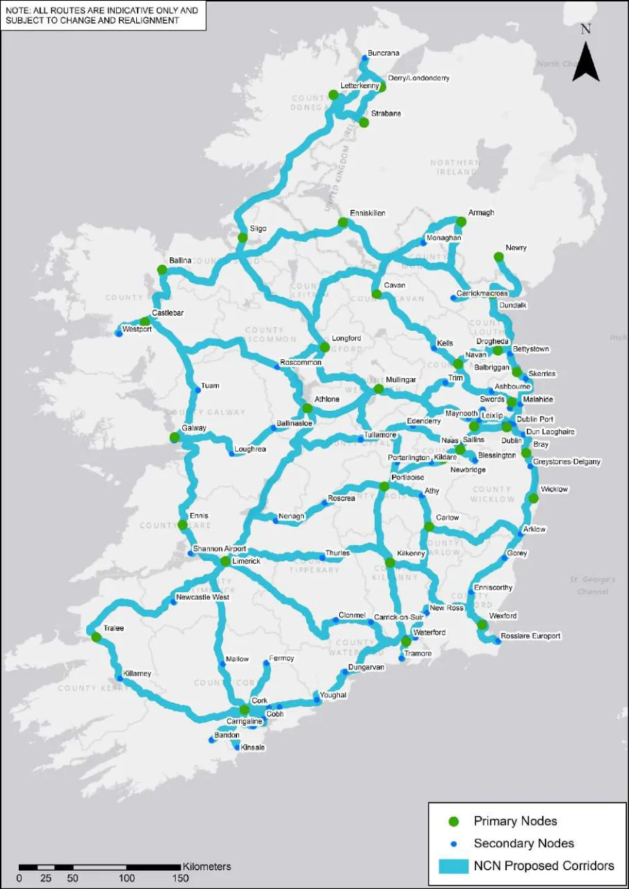
Figure 6.1 Preferred Corridors for NCN Post Public Consultation
National Cycle Network Plan
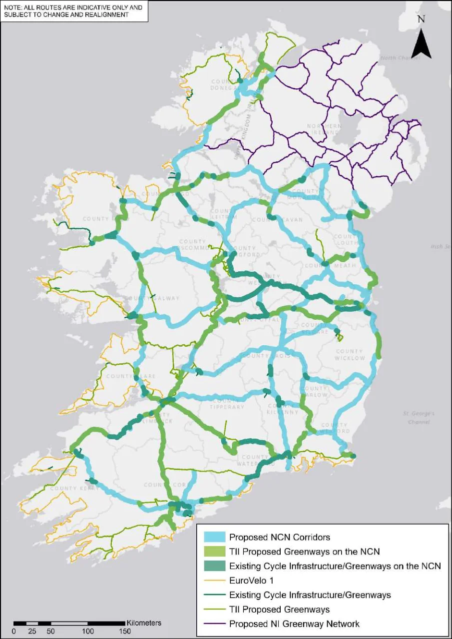
Figure 6.2 Preferred Corridors for NCN Post Public Consultation, Existing and Planned Cycle Networks /
Figure 6.2 Preferred Corridors for NCN Post Public Consultation, Existing and Planned Cycle Networks / Infrastructure
National Cycle Network Plan
As an inter-urban network, it is proposed that the NCN will extend into urban areas, connecting one urban centre to another. Where an urban cycle network already exists (or is planned), the NCN will integrate with the highest quality of service or most appropriate route to the urban centre (e.g., connecting with a segregated cycle track rather than unprotected cycle lane). Where an urban cycle network does not exist (or is in the planning stage), the NCN integration points will be reassessed in line with planning stages.
Continued close collaboration with the NTA and local authorities will assist in successfully integrating the NCN with existing and planned urban networks across the country. Figure 6.3 an example of the NCN integrating with a local / urban network.
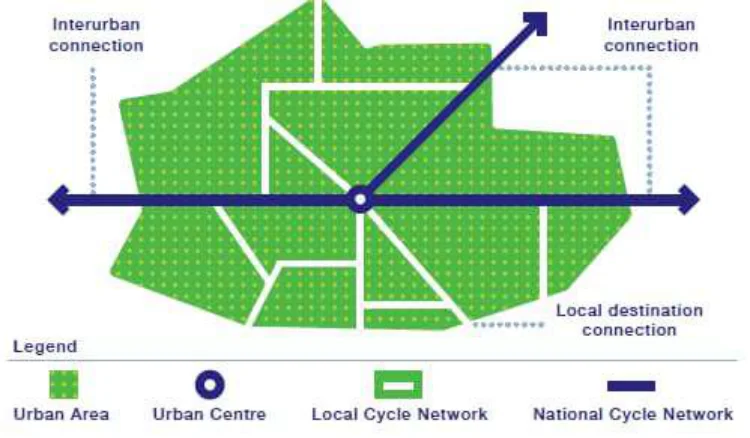
Figure 6.3: NCN Integration with Local / Urban Cycle Network
6.2Benefits of the NCN
As well as contributing to Ireland’s commitments to sustainability and decarbonisation, successful implementation of the NCN Plan will provide many benefits for cyclists and communities across Ireland, including:
Ensuring delivery of a high-quality cycle network which will promote safety, comfort and increased participation in cycling.
Improving sustainable connectivity for nationally and providing links with other networks such as CycleConnects, EuroVelo and Northern Ireland networks.
Supporting both urban and rural economies through increased leisure and tourism cycling.
Improving public health through well documented benefits of more active travel.
Guiding how local authorities prioritise exchequer-funded investments in cycle infrastructure.
Making use of existing infrastructure wherever possible including greenways, road infrastructure, and declassified roads where safe and appropriate cycle experiences can be provided.
Some of documented evidence of the potential benefits arising from cycle network delivery internationally are as follows:
Investing in cycling infrastructure offers a high return on investment. For example, the UK Department for Transport estimates that the average benefit-cost ratio for walking and cycling
National Cycle Network Plan
delivers benefits of 13 to 35 times the cost8. In New Zealand, transport planners estimate that money spent of cycling infrastructure delivers benefits of between 10 to 25 times the costs9.
Cycle tourism will add to the economic benefits of cycling. As an Irish precedent, a survey of users of the Waterford Greenway showed that 68% of the respondents that lived outside of Waterford said that the Greenway was the main reason for their visit, while a further 20% said it was “somewhat important”. Of the respondents who had accommodation costs, it averaged €106 per night, while the average spend on food drink and bike hire of users sampled was €16.90 per day11. This expenditure will support local businesses that are likely to develop around the NCN providing services for users such as coffee shops, restaurants, bicycle rental and bicycle repair, all of which will contribute to the local economy.
The European Cycling Federation estimates that cycling tourism is worth approximately €44 million to the European economy, higher than that of the cruise ship tourism12. International cycle tourism represents only a small proportion of tourism in Ireland at present, however, this sector may grow particularly with growth of the cycle network facilitating movement between key nodes and tourism destinations.
Encouraging more active modes of travel using safe infrastructure has benefits including reducing the risk of disease and enhancing mental health. The health benefits from cycling have also been associated with increased productivity. In Copenhagen, residents who cycle have requested 1.1 million fewer sick days which is approximately 2 fewer sick days per resident. Similarly, children travelling to school by bicycle are likely to have greater concentration13.
Environmental benefits can be achieved even for small changes in behaviour. A study of 2,000 urban dwellers across Europe has shown that switching from car to bike for one trip, just one day per week, resulted in a reduced carbon footprint of about 0.5 tonnes over the year14. Therefore, investing in the NCN to provide safer connections between amenities and urban settings, has the potential to result in small, but cumulatively significant, changes in behaviour of the 2.8 million people that will be living close by.
6.3NCN Infrastructure Requirements
Safety was highlighted as a key concern during public and stakeholder consultation. While the NCN Plan does not include design for specific routes, the provision of a safe and attractive network that is fully accessible is included in the plan’s vision statement. Design principles for the NCN to meet its objectives in relation to safety and accessibility were developed based on an assessment of both international and national standards and approaches.
Design Case Studies
In the development of the NCN Plan, cycle network design guidelines / requirements currently in place in Germany, the United Kingdom (UK), and the Netherlands were reviewed. Appendix B presents these case studies including relevant details regarding existing cycle infrastructure and cycle trips, cycle policy, and examples of specific design requirements (focusing on link types),
Each of the policies and design guidelines examined include overarching goals, objectives and / or principles to assist planners / designers in their work. While the segregation of modes is prioritised in each country as a key element of providing safe cycle infrastructure, it is acknowledged that this is not
8 Transport for London, Economic Benefits of walking and Cycling. 9 Macmillian, A, Connors, J., Witten,. K, Kearns,. Rees, D., & Woodward, Alistair. (2014). The societal costs and benefits of commuter bicycling: Simulating the effects of specific policies under system dynamic modelling. Environmental Health Perspectives. 122(4). 11 AECOM,(2017). Waterford Greenway Intercept Survey 201. Baseline Survey Report. 12 Cycling worth €150 billion a year to the EU economy, says new report | road.cc 13 The Danish cycling culture | Read why Danes bike everywhere (denmark.dk) 14 Brand, C., Götschi, T., Dons, E., Gerike, R., Anaya-Boig, E., Avila-Palencia, I., … & Nieuwenhuijsen, M. J. (2021). The climate change mitigation impacts of active travel: Evidence from a longitudinal panel study in seven European cities. Global environmental change, 67, 102224.
National Cycle Network Plan
always achievable. Including guiding principles as well as minimum standards allows planners / designers some flexibility to work within whatever restrictions each project presents while also aiming to provide a safe and inviting experience for the cyclist. As such, while the recommended lane width may vary, the overarching priority of ensuring a safe trip for cyclists is common to all.
It is interesting to note the different approaches taken to determining the most appropriate cycle infrastructure, as follows:
Germany considers the vehicle speed limit of the road and the peak hour flow of cyclists.
The UK considers the vehicle speed limit of the road and the total motor traffic flow per hour.
The Netherlands considers the ratio of motorists to cyclists within a certain timeframe.
The findings from the design case studies helped to inform the design principles outlined below. These principles follow a similar approach of defining preferred and potentially acceptable infrastructure types. These are effectively minimum standards for the NCN. The decision on which type of infrastructure to use on which corridor will be case-specific, however and will depend on factors such as vehicular speed limits and traffic flows as well as potential cycle demand.
NCN Design Principles
A review to determine suitable cycle infrastructure types for the NCN also looked at approved cycle infrastructure in Ireland based on the following national guidance documents:
The NTA National Cycle Manual (cyclemanual.ie).
TII Design Standard “Rural Cycle way Design (Offline & Greenway).15
TII Advice Note “Provisions for Cyclists and Pedestrians on Type 2 and Type 3 single carriageway National Roads in rural areas”.16
The infrastructure types were considered in the context of the objectives of the NCN Plan and the findings of the design case studies to determine their suitability for use in the NCN. At this stage, a number of infrastructure types were deemed unsuitable and removed from consideration.
The infrastructure types, summarised in Table 6.2, are classified as:
Preferred - The desired standard for infrastructure on the NCN. Where possible, every effort should be made to ensure that one of these infrastructure types is implemented when delivering a route; or
Potentially Acceptable– It is acknowledged that it may not always be possible to provide one of preferred infrastructure types in some locations due to site and / or other constraints. In such circumstances, these infrastructure types may be acceptable, subject to site-specific evaluation.
As well as traditional cycle infrastructure types, consideration has also been given to the potential use of “quiet” roads as part of the proposed network – existing roads where traffic volume and speed could be managed to provide a cycle friendly environment for cyclists. A separate study is being undertaken to produce a recommendation in regard to incorporating existing shared road space (i.e., “quiet” roads) into the proposed NCN and detailing the standard of potential interventions required for this type of facility, particularly in rural settings.
15 https://www.tiipublications.ie/library/DN-GEO-03047-03.pdf 16 Although this advice note has been withdrawn, it is considered applicable for identifying the types of cycle infrastructure typically found on national roads in rural areas.
National Cycle Network Plan
Table 6.2: Types of Infrastructure Identified and Suitability for use on the NCN
| Type | Description | Example | Note / Comment | Suitable | Classification | ||
|---|---|---|---|---|---|---|---|
| Location | |||||||
| Cycle Trail | A facility which is distinct from the vehicular road corridor and comprised of elements such as canal tow paths, disused railways and other such paths | Fully segregated infrastructure | Both Rural & Urban | Preferred | |||
| Off-Road Cycleway (cycle track) | Physically separated from the vehicular road carriageway by a verge or some other form of physical segregation; however, it remains within the road corridor | Physical segregation desirable for NCN, | Rural | Preferred | |||
| On-Road Cycle lane (TII): | Located within the contiguous road pavement surface and is separated from motorised traffic by a segregation strip at least 0.5m wide and delineated by road markings | More physical segregation preferrable for NCN, however, continuous white line separation may be appropriate for certain sections / locations. | Urban | Potentially Acceptable |
National Cycle Network Plan
| Type | Description | Example | Note / Comment | Suitable | Classification | ||
|---|---|---|---|---|---|---|---|
| Location | |||||||
| Standard Cycle Track (NTA) – At-Grade | Segregation between cyclist and motorised vehicles through bollards | More definitive physical segregation preferrable for NCN | Both Rural & Urban | Potentially Acceptable | |||
| Standard Cycle Track (NTA) – Behind Verge | Grass or paved verge separating cycle track from carriageway | Similar to TII off- road cycleway | Urban | Preferred | |||
| Contra- Flow | Cycle facilities within an urban one-way system | Cycle facilities within an urban one-way system. | Urban | Potentially Acceptable |
National Cycle Network Plan
| Type | Description | Example | Note / Comment | Suitable | Classification | ||
|---|---|---|---|---|---|---|---|
| Location | |||||||
| Standard Cycle Track (NTA) – Raised | Physical segregation by full kerb height between cyclist and motorised vehicles | Physical segregation preferrable for NCN | Urban | Preferred | |||
| Standard Cycle Track (NTA) – Two-Way | Physical separation from carriageway by dividing verge. Physical separation from footpath by verge or height difference | Physical separation preferrable for NCN | Both Rural & Urban | Preferred | |||
| Quiet Roads | On carriageway shared use of existing roads, where traffic volume and speed are managed to provide a cycle friendly environment for cyclists | Separate study being undertaken to develop this option | Rural | Potentially Acceptable |
National Cycle Network Plan
Pages 36–56 · View in original PDF