1 way
In lower-traffic roads (under 500 vehicles per hour during peak times) and on roads subject to lower speed limits (such as 30km/h zones), cycle traffic can share a road with motorised vehicles. In the RASt, design guidelines are given on advisory lanes, cycle lanes, and cycle paths.
‘Advisory lanes’ are separated from the main road by broken white lines and can be implemented where mixed traffic on the road is acceptable but for safety reasons (higher speed limits and 500- 1,000 vehicles per hour) the cycling traffic needs to be given a dedicated space. ‘Advisory lanes’ are suited to two-lane roads and may also be installed on single-lane carriageways and on multiple-lane approaches to junctions and within the directional lanes. Motorised vehicles may enter these lanes to overtake. The standard width of the advisory lanes including markings should be 1.5m, with a minimum of 1.25m. The remaining road space for dual carriageways should exceed 4.5m (minimum width of 2.25m per lane for cars). Adjoining parking may also be implemented alongside advisory lanes. A minimum width of 2.0m is required for these ‘parking bays’.
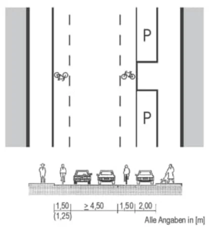
Figure from page 100
Figure B.10 : Example of Dimensions of Advisory Lanes (RASt)
‘Cycle Lanes’ are recommended on roads with a higher speed limit (over 50km/h) and with a higher vehicle usage (usually over 500 vehicles per hour). They are separated from the main road by a lane edge marking, usually 0.25m wide. These lanes should have a colour and / or material differentiation from the main road. It is mandatory for cyclists to use these lanes when they are available. Suitable parameters for the main road are carriageway widths
4 https://www.fgsv-verlag.de/pub/media/pdf/200_E_PDF.v.pdf
up to 6.0m in traffic volumes up to 500 vehicles per hour and carriageway widths of 7.0m in traffic volumes up to 1,000 vehicles per hour to allow for safe overtaking for cars without endangering cyclists.
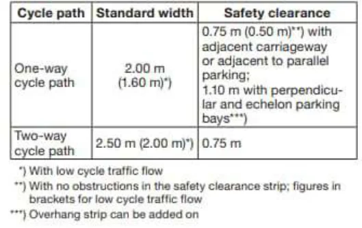
Figure from page 101
‘Cycle Paths’ that run adjacent to roads should be segregated from the main road or parking bays by a separating safety strip. They should be clearly differentiated from the footpath and marked out accordingly through appropriate signage and road be implemented in two-way cycle traffic on one or both sides. Standard widths should be consistent, with widths only being reduced on short stretches, such as restrictions due to built infrastructure. Greater widths may be required on main cycle network routes, in areas of high cycle traffic loads (such as near schools), where cycling traffic is likely to increase at peak times, and on major
Figure B.11 : Criteria for Cycle Lanes Alongside Roads (RASt)
In some one-way streets, a contra-flow cycle lane may be introduced if motorists have a speed limit of 30km/h, and the motor-traffic lane is a standard width of 3.5m or more (or 3.0m with dedicated passing points on the route). Appropriate signage must also be introduced to signify to drivers that cyclists may pass in the opposite direction. Table B.2 provides a summary of the differing cycle route types and their respective minimum design standards.
The German National Cycling Plan incorporates many aspects other than just infrastructure, but its overall objectives make the purpose of infrastructure design clear and aim to provide guidance to planners / designers when interpreting design standards. Including a ‘What’s Most Important’ component in the National Plan also highlights the ‘why’ behind each objective.
Determining Link Type based on Demand
Longer inter-urban routes will incorporate varying levels of demand depending on where each section is (e.g., urban, suburban, rural). Defining the link type requirement based on anticipated demand allows a single corridor to include multiple link types, however, where underlying demand is difficult to determine (or potentially supressed due to poor existing infrastructure) this could result in the development of sub-
The UK was selected as a case study based on having a similar governance structure with regards to road policy and management, as well as having similar geography and pre-existing cycle infrastructure to Ireland. The UK’s cycle infrastructure is made up of national, regional and local networks. While the National Cycle Network is overseen by a single entity, Sustrans, and is relatively comprehensive, consisting of over 20,000km of sign-posted routes across the country, regional and local networks are administered by separate authorities. For example, Transport for London (TfL) oversees the Cycleways network (formerly Cycle Superhighways and Quietways) which are routes that link communities, businesses, and destinations (TfL, 2022). Similar networks are found in many of the major cities throughout the UK and are designated by the local governing body.
National Cycle Network Plan - Appendices
While the national government is responsible for overseeing cycle strategies and high-level policies in the UK, most of the responsibilities for implementing cycling infrastructure are at a local level (UEL, 2010). In England, the Department for Transport (DfT) is responsible for cycling policy: It provides guidance to local bodies as well as overseeing the work of its advisory body, Cycling England, which aims to increase active travel throughout the country. In Scotland, Wales, and Northern Ireland the bodies responsible for cycling policy are the Scottish Executive, the Welsh Assembly Government, and the Department for Regional Development, respectively.
In 2020, DfT announced the formation of a new funding body and inspectorate, Active Travel England (ATE), to enforce the standards and time limits, and raise performance generally. The agency is expected to be fully operational in late 2022. Budgets for cycling projects will be controlled ATE, which will be led by a national cycling and walking commissioner. ATE will examine all applications for funding and refuse those not compliant with the new national standards. It will inspect finished schemes and seek the return of funds for any which have not been completed as agreed, or which have not met stipulated timelines. ATE will also inspect, and publish annual reports on highway authorities, grading them on active travel performance and identifying particularly dangerous failings in their networks for cyclists and pedestrians. The Department for Transport’s Cycle Infrastructure Design manual and Sustrans’ Cycle for Everyone report have been published to support the implementation of cycle infrastructure in the UK. These documents are guidelines rather than minimum standards that must be adhered to and act as a reference point for designers at a local level. In the UK, local authorities are responsible for setting design standards on their roads (DfT, 2020). There is an expectation that local authorities will give due consideration to the guidance produced by these national level documents when designing new cycling schemes and, in particular, when applying for government funding. In terms of the national network, while Sustrans only owns a very small percentage of the network (2%), it does determine the standards for inclusion, improvements and developments.
Over the course of 2020/21, over £220m was provided to local authorities in England through two stages of the Active Travel Fund to reallocate road space and create dedicated routes for cycling and walking, £100m was provided to Transport for London to enable it to deliver the London Roadspace Programme, which has produced over 60 miles of new segregated cycle lanes in the country’s capital, and £20m was provided to local authorities to allow them to deliver a wide range of programmes to increase the number of people walking and cycling (Department for Transport, 2021).
Cycle Infrastructure Design Manual
TheCycle Infrastructure Design manual5 published by DfT in 2020 is a comprehensive document of guidelines that aims to support the delivery of high-quality cycling infrastructure. The document succeeds the Cycling and Walking Investment Strategy 1 that secured over £1Bn in funding for active travel between 2016 and 2021 (Hawkes, 2021). Inclusive cycling is the underlying theme of the document ‘so that people of all ages and abilities are considered’. The manual provides a recommended basis for design standards based on five overarching design principles and 22 summary principles.
This manual provides guidance for local authorities and defines the minimum criteria for funding. Schemes that do not meet these minimum criteria may still apply but require additional justification (DfT, 2020).
To promote the five overarching design principles of coherence, directness, safety, comfort and attractiveness, the manual includes a table that summarises the traffic conditions when protected spaces for cycling (fully kerbed cycle tracks, stepped cycle tracks, and light segregation), marked cycle lanes without physical features, and cycling in mixed traffic are appropriate. For example, a cycle lane with a speed limit of 20mph (approximately 30kph) and a motor flow of 2500pcus (passenger car units) per day is defined as a ‘provision suited for most people’, whereas a cycle route integrated with traffic
National Cycle Network Plan - Appendices
(mixed traffic) with a speed limit of 30mph (approximately 50kph) and a motor flow of 3500pcus per day is a ‘provision suited for a few people and will exclude most potential users’ (DfT, 2020).
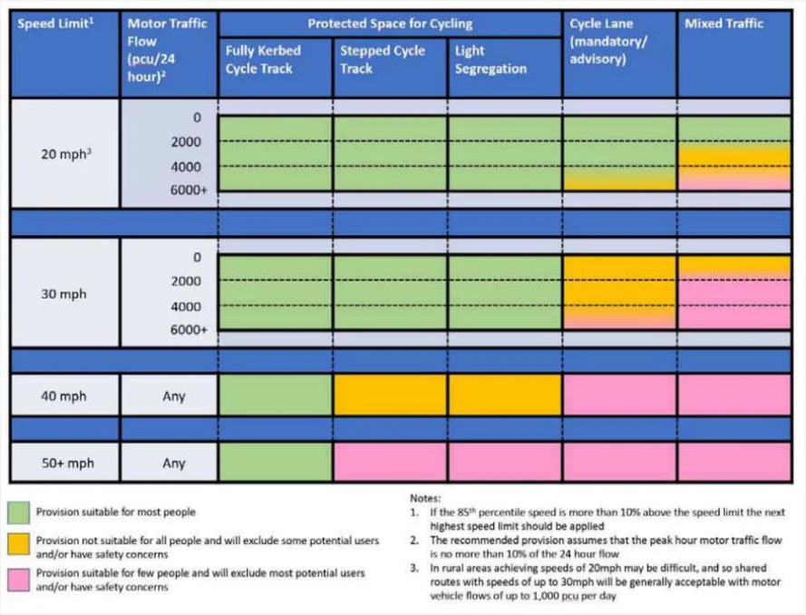
Figure from page 103
Figure B.12 : Appropriate Types of Cycling Infrastructure (the Cycle Infrastructure Design Manual)
The manual’s 22 summary principles, listed below, aim to assist in delivering high quality infrastructure based on common best practices and lessons learned. (DfT, 2020) 1. Cycle infrastructure should be accessible to everyone from 8 to 80 and beyond: it should be planned and designed for everyone. The opportunity to cycle in our towns and cities should be universal.
-
Cycles must be treated as vehicles and not as pedestrians. On urban streets, cyclists must be physically separated from pedestrians and should not share space with pedestrians. Where cycle routes cross pavements, a physically segregated track should always be provided. At crossings and junctions, cyclists should not share the space used by pedestrians but should be provided with a separate parallel route.
-
Cyclists must be physically separated and protected from high volume motor traffic, both at junctions and on the stretches of road between them.
-
Side street routes, if closed to through traffic to avoid rat-running, can be an alternative to segregated facilities or closures on main roads – but only if they are truly direct.
-
Cycle infrastructure should be designed for significant numbers of cyclists, and for non-standard cycles. Our aim is that thousands of cyclists a day will use many of these schemes.
-
Consideration of the opportunities to improve provision for cycling will be an expectation of any future local highway schemes funded by Government.
National Cycle Network Plan - Appendices
-
Largely cosmetic interventions which bring few or no benefits for cycling or walking will not be funded from any cycling or walking budget.
-
Cycle infrastructure must join together, or join other facilities together by taking a holistic, connected network approach which recognises the importance of nodes, links and areas that are good for cycling.
-
Cycle parking must be included in substantial schemes, particularly in city centres, trip generators and (securely) in areas with flats where people cannot store their bikes at home. Parking should be provided in sufficient amounts at the places where people actually want to go.
10.Schemes must be legible and understandable.
11.Schemes must be clearly and comprehensively signposted and labelled.
12.Major ‘iconic’ items, such as overbridges must form part of wider, properly thought-through schemes.
13.As important as building a route itself is maintaining it properly afterwards.
14.Surfaces must be hard, smooth, level, durable, permeable and safe in all weathers.
15.Trials can help achieve change and ensure a permanent scheme is right first time. This will avoid spending time, money and effort modifying a scheme that does not perform as anticipated.
16.Access control measures, such as chicane barriers and dismount signs, should not be used.
17.The simplest, cheapest interventions can be the most effective.
18.Cycle routes must flow, feeling direct and logical.
19.Schemes must be easy and comfortable to ride.
20.All designers of cycle schemes must experience the roads as a cyclist.
21.Schemes must be consistent.
22.When to break these principles. In rare cases, where it is unavoidable, provision of a short stretch of inferior infrastructure rather than jettison an entire route which is otherwise good will be appropriate. But in most instances, it is not absolutely unavoidable and exceptions will be rare.
Numerous geometric design guidelines and tables for various cycle infrastructure including amenities and signage are also provided in the manual. The recommendations state that ‘designers should aim to provide geometry to enable cyclists to proceed at a comfortable speed, typically around 20mph [30kph]’ (DfT, 2020). The manual also discusses different dimensions that are required to accommodate cyclists on a variety of cycles and trailers when travelling at their desired speeds. Desirable minimum widths are given, ranging from 1.5m to 4.0m depending on whether the cycleways are unidirectional or bidirectional, on peak-hour cycle flows, and on cycle infrastructure type.
National Cycle Network Plan - Appendices
Table B.3 : Cycle Lane and Track Widths (extract from Cycle Infrastructure Design manual)
| Cycle Route Type | Direction | Peak hour cycle flow | Desirable minimum width* (m) | Absolute minimum at constraints (m) | ||
|---|---|---|---|---|---|---|
| (either one way or two- | ||||||
| way depending on cycle | ||||||
| route type) | ||||||
| Protected space for cycling (including light segregation, stepped cycle track, kerbed cycle track) | 1 way | <200 | 2.0 | 1.5 | ||
| 200-800 | 2.2 | 2.0 | ||||
| >800 | 2.5 | 2.0 | ||||
| 2 way | <300 | 3.0 | 2.0 | |||
| >300-1000 | 3.0 | 2.5 | ||||
| >1000 | 4.0 | 3.0 | ||||
| Cycle lane | 1 way | All – cyclists able to use carriageway to overtake | 2.0 | 1.5 |
Pages 100–105 · View in original PDF