1 Sligo County Council:
An essential element of the Strategy is recognising existing and ongoing success, which can be harnessed to deliver impact. While the concept of demand management may be in its infancy in Ireland, there are many national and international examples of successful implementation in this area – examples that could be leveraged by other local authorities and agencies to achieve the objectives set out in this Strategy. The following represents a sample summary of case studies that were gathered to inform this Strategy and published as part of the public consultation process in 2024. As well as a case studies compendium, the subgroup reports featured many relevant examples of learnings from practice40.
Background
In 2023, as part of the Pathfinder Programme, Sligo partnered with Bolt to extend their shared e-bike scheme. Part of the motivation for this project was to make Sligo a “3km Cycle Friendly Town”. The Bolt e-Bike pilot had initially begun in July 2022. Initially intended as a 6-month pilot, it was extended for 12 months due to its popularity and success. The trial scheme included 40 designated bike parking areas around Sligo Town, with 80 bikes. The trial was successful, and has now been further extended, with additional charging stations, and more than 10,216 unique users recorded as of May 2025.
National Case Studies
Measure Impact
The pilot sought to understand if a shared e-bike scheme could encourage the desired modal shift from private car usage towards sustainable transport within Sligo. Since its introduction, over 194,844 trips have been taken on the e-bikes, travelling over 371,534 kms (as of May 2025). The average journey is 9 minutes and covers a journey of 2km. The high uptake and usage following the pilot demonstrated the success of the scheme and helped to justify the case for an active travel corridor connecting Carraroe, Sligo Town and Atlantic Technological University which is currently being developed.
- Sligo County Council: Active Travel
Sligo County Council established a partnership with mobility companies, to provide a new active travel offering to its citizens and tourists with minimal cost to the local authority. Through this partnership, Sligo gained access to data to support future decision making on further provision of active travel infrastructure.
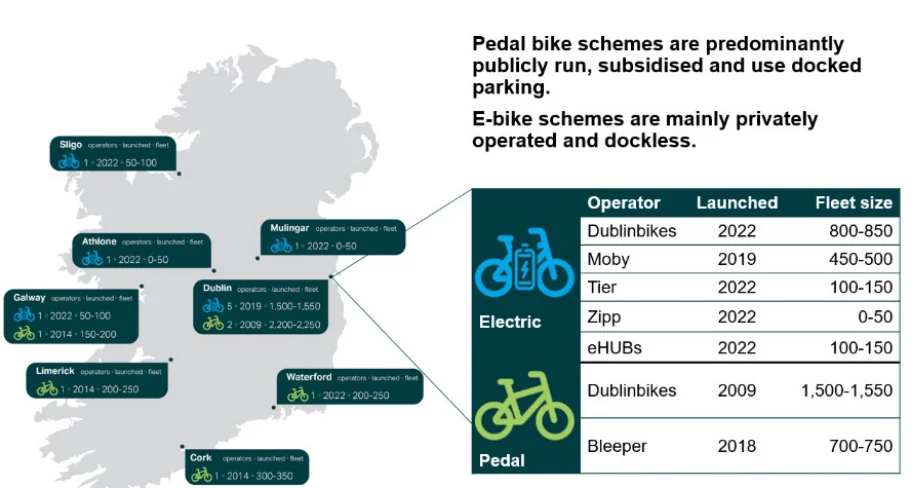
Figure 18: Bike and e-bike rental schemes in Ireland as of 2023
Lessons Learned
Background
Utilising a pilot approach is an effective tool for delivering impact in a short timeframe and can be easily replicated through the continuation and broadening of current schemes. Additionally, shared mobility including e-bikes, scooters or on-demand shared transport offer the benefits of geocoding and GPS tracking to collect detailed trip data. This is helpful to understand where travel demand exists and can be used to support the justification of more sustainable infrastructure, as seen with the planned active travel corridor connection between Sligo Town and ATU.
Cork City Council pedestrianised the streets of Cork City centre temporarily in the summer of 2020 as part of ‘Reimagining Cork City’ programme. In January 2021, the seventeen streets in Cork City centre were permanently pedestrianised.
Initially, the scheme was established in response to the Covid-19 pandemic and the need for accessible public space – reallocating road space so that pedestrians could move about at a safe distance from each other. Good air quality is an important long-term objective for Cork City Council. The pedestrianisation initiative not only supports public health, but also creates a liveable and people-friendly city. Cork also hosted its first car-free day on September 23rd, 2023, in the city centre as part of a pilot initiative. The car-free area stretched from Grattan Street in the west of the city centre as far as the Custom House building in the east of the centre, a total of 1.7km by car.
- Cork City Council: Pedestrianisation and Carfree Initiatives
Cork City Council reallocated road space to active travel and pedestrians across the city centre, utilising a variety of funding streams. These pilots allowed Cork City to establish an evidence base (e.g. measured improvements in air quality) and to take on board learnings in order to better refine future iterations of these initiatives.
Measure Impact
Both initiatives provided the public with the opportunity to reimagine a different reality for the city centre and to understand how the absence of cars on the pedestrianised streets could improve the day-to-day experience of residents and
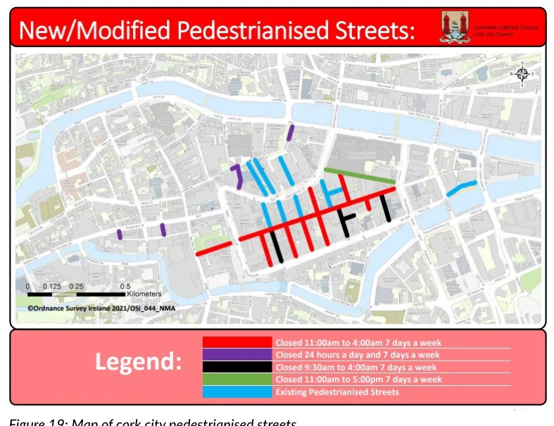
Figure from page 141
Figure 19: Map of cork city pedestrianised streets
visitors alike. As part of the car free day pilot, air quality impacts were analysed via air-node sensors installed at appropriate locations. The sensors measure nitrogen oxide (NO2), which is strongly associated with traffic-related emissions. At midday on 23 September 2023, the car-free day pilot commenced, and within 10 minutes, there was a recorded reduction in NO2 of 50%. Over the next 50 minutes, the sensors recorded further reductions in NO2 until 3pm. From 3pm, the levels of NO2 steadily rose, before returning to typical pre-car free day levels by 5pm.
Blackrock. The combination of these projects entitled Living Streets is in essence a 10-minute town model. A key part of the Living Streets case study is the 4.5km coastal mobility route (CMR), which links five villages along the South Dublin coast between Blackrock to Sandycove.
Measure Impact
DLRCC worked with Technological University Dublin (TUD) to develop an evaluation framework to define what data needs to be collected for monitoring and analysis. The independent evaluation of the CMR by TUD found that the route demonstrated positive impacts both in terms of mobility and from a socio-economic perspective. It is the highest performing cycle route in the DLR area, with bike trips increasing through the provision of quality cycle infrastructure. In terms of business and economic impact, businesses interviewed along the CMR were largely positive regarding its economic impact and accepted or supported its ongoing presence. Several businesses noted an increase in footfall.
Recommendations and Lessons Learned
These initiatives are replicable across all scales and settlement types but there is a need for monitoring expertise. By collaborating with institutions such as universities, there is the possibility to access equipment, skills and resources which may not otherwise be available in the local authority. Vehicle restrictions on some streets can lead to more air pollution on other streets, where the air flow is less. Using low-cost sensors for street scale monitoring can provide enhanced data.
The Blackrock main street redesign also had significant stakeholder support with 84% and 72% of surveyed residents and businesses, respectively, confirming the new layout is a good addition.
Lessons Learned
- Dun Laoghaire-Rathdown County Council:
A lesson learnt from implementing the schemes in Blackrock and Dun Laoghaire is the need to use tactical urbanism or pilots to illustrate the benefits of a scheme. It is important to use language that highlights the benefits to the community – focus on improving the streets and green spaces. Regular engagement helps to bring people along on the journey, furthering support. Having strong input and buy-in from resident or business community is important and valuable to success.
Public Realm and Coastal Mobility Route
Background
DLRCC introduced initiatives including segregated cycleways, public realm design, and reconfigured vehicle circulation to support pedestrians and cyclists in the area Dun Laoghaire as well as
Engaging with a single representative body (e.g. a chamber of commerce) can be useful, while seeking broader inputs. One recommendation is to manage the narrative of the scheme, in terms of highlighting the long-term success and positive qualities that the scheme brings. Telling the story well creates buy-in.
Dun-Laoghaire Rathdown County Council (DLRCC) has taken a multi-disciplinary approach to public realm improvements and the enhancement of active travel infrastructure, drawing on expertise across communications and accessibility to complement technical excellence. By prioritising engagement and leveraging realised success in other areas, they were able to secure buy-in and build public support across the Blackrock and Dun Laoghaire areas.
A multi-disciplinary team that can work without silos and understands the project is efficient in implementing the scheme. Ensuring universal design and engaging with disability or community groups on co-design of the scheme is crucial to ensure accessibility and inclusion.
- Dublin City Council I: Parking Regulations
When existing schools apply for alterations and extensions, DCC seeks removal or reduction in car parking on site, the provision of cycle and scooter parking and the preparation of a School Travel Plan.
Dublin City Council utilises carparking policy as a tool to deliver modal shift and behavioural change in urban areas. In addition, Dublin City is actively innovating to support the optimisation of freight, introducing freight consolidation, last-mile green delivery and innovative technologies in the movement of goods in the city.
In recognition of hospitals as large employment centres with some in Dublin having thousands of staff, DCC has been working proactively to make hospital campuses more sustainable. Since the mid-2000s DCC has required hospitals to undertake car parking and staff travel surveys. DCC has worked with hospitals to develop sustainable mobility strategies for the hospital campuses with restriction of car parking and proactive car parking management central to the approach.
Background
Over the last two decades, Dublin City Council has embedded sustainable car parking policies in the city development plans with a particular emphasis on car parking as a mechanism to reduce congestion and encourage modal shifts. Limiting car parking at destination has been policy for Dublin City Council since the early 2000s, and this was strengthened by the 2005-2011 Dublin City Development Plan, which brought in maximum, accessibility-based car parking standards based on three zones across the city. DCC has been working to remove free on-street carparking over the past two decades and on-street Pay and Display schemes have been implemented in efforts to reduce long term on-street commuter parking in favour of short-term parking. Car clubs have also been a new feature of shared mobility over the last decade to address changes to car parking at destination. Regarding residential car parking, maximum accessibility-based standards are also applicable to residential developments. DCC has developed an integrated approach to mobility planning for new residential developments in collaboration with the developers of the sites41. For each site, an integrated mobility strategy is developed.
Measure Impact
The implementation of all these policies results in minimal car parking at destination, maximum accessibility-based standards at origin and the introduction of sophisticated travel and mobility planning in schools, businesses and hospitals. In the case of business use, the policies have been effective mechanisms for behavioural change.
Dublin City Council II: Kerbside Management Pilot
Background
Kerbside management refers to the planning, organisation and regulation of activities that take place at the edge of the roadways, specifically the areas adjacent to the kerb. The kerbside plays a crucial role in urban transportation as it provides space for various activities, including parking, loading and unloading, public transit stops, pedestrian facilities and cycling infrastructure.
With the growth in technology and new modes of transport, it has become increasingly important to manage competing demands on the kerbside in order to create an urban space where communities can thrive.
DCC works proactively with the Department of Education and Youth to develop sustainable mobility strategies for the new schools. New schools have been developed as car-free with only limited accessible car parking spaces. This approach is supported by the provision of highquality cycle and scooter parking provision, maximisation of permeability to the schools, improvements to the surrounding environs and the preparation of School Travel Plans.
Measure Impact
Led by Smart Dublin, two kerbside management platforms were trial and tested with different teams in Dublin City Council. Different data
41 Dublin City Development Plan, 2022 - 2028 - Volume 2:
Dublin City Council III: Micro Consolidation Centres (Eco Hubs)
sets that were either surveyed or pulled from open data sets and made available on the digital platform. The pilot captured more than 15 unique kerb regulations with 4000+ data points for 60+ kerb kilometres.
Background
Recommendations and Lessons Learned
A Micro Consolidation Centre refers to a strategically positioned logistics facility situated within the boundaries of the urban area, specifically focusing on Dublin City Centre. This hub serves a defined geographical scope and facilitates a transition to low-emission vehicles or alternative modes of transportation, such as walking and cargo bikes, for the final phase of product deliveries.
Keeping the kerbside maps up-to date posed as a real challenge for the pilot. Smart Dublin realised that the data could be kept updated in two ways (1) the City Council teams update the maps whenever any changes were made on the streets. This would require major process changes and would not be viable for a small pilot project; (2) A third party would be required to resurvey the area, under contract, on a quarterly basis using either LiDAR or mobile mapping.
The Dublin City Development Plan sets out policies and objectives to guide how and where development will take place in the city over the lifetime of the Plan. Under the plan for 2022- 2028, Dublin City Council commit to achieving a significant reduction in the number of motorised delivery vehicles in the city through supporting and promoting the use of the ‘last-mile’ delivery and the development of sustainable deliveries eco hubs and distribution centres.
It is also important for the local authorities to use common data standards to advance their kerb management journey. Smart Dublin, which is part of the Open Mobility Foundation (OMF), is also exploring Curb Data Specifications (CDS). CDS is developed as an open standard by a public Curb Management Working Group that began work in 2020 and includes 160+ leaders of major US cities, transit systems, global automotive and delivery enterprises, and technology startups.
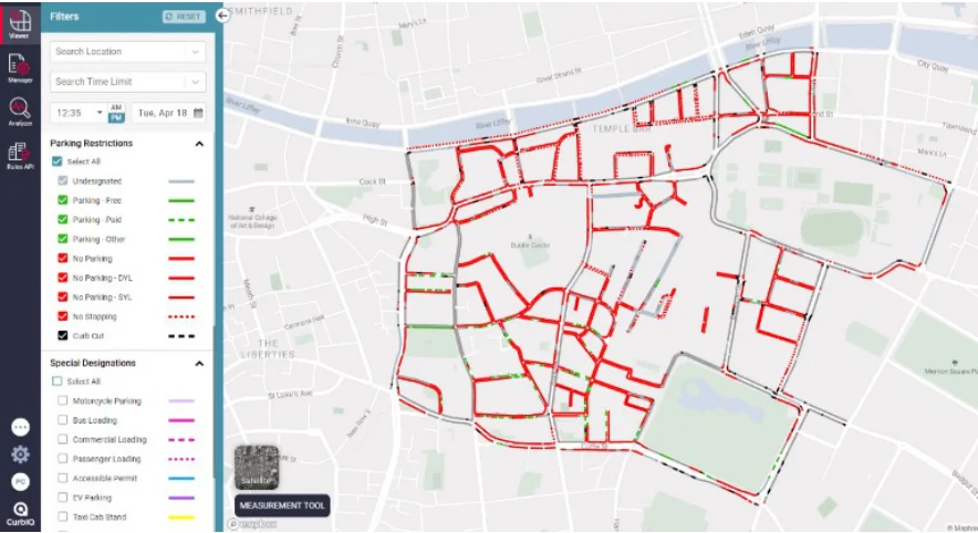
Figure 20: Kerbside management tool
Measure Impact
Dublin City Council published an Eco Hub Bye Law in 2018 under which a Sustainable Deliveries Eco Hub Operator (Delivery and/or Logistics Companies) can apply to the Council for a Licence to operate an on-street Sustainable Deliveries Eco Hub prior to commencing operation.
UPS (United Postal Services) is operating eco hubs successfully at two locations and through these hubs UPS has eliminated the use of five diesel delivery vehicles in the city centre, easing congestion and reducing CO2 emissions by up to 45% in 2020 .
Recommendations and Lessons Learned
Public space in Dublin is ever-changing and this can make it difficult for local authorities to accommodate the demand of public space to host the eco hub. Hence, Dublin City Council is now seeking solutions to facilitate the sustainable deliveries of eco hubs and distribution centres in off-street locations in Dublin City by working closely with the delivery companies and infrastructure providers.
Pages 140–145 · View in original PDF