8 Planning for Sustainable Transport
- Planning for Sustainable Transport
8.1 Introduction
“The objective of transport investment is to contribute to economic, social and cultural progress of the Region, and the protection and enhancement of the environment, in line with Government priorities in other sectors.
Transport is a derived demand, in that people travel primarily out of a need for other things such as education, work and shopping. The management of this demand where it is created is a critical element of transport planning in the GDA. The pattern of where people live, work, attend school or college, socialise etc. is therefore the key determinant in the type of transport system we require. Historically in the GDA, the location of services and employment, and the policy of providing car-based solutions to transport problems has led to the creation of an overly car-dependent city-region. The consequences of this include issues such as congestion, air pollution, severance, unattractive urban environments, poor walking and cycling environments, and a public transport system which is significantly compromised by the requirement to serve travel patterns which are dispersed and complex.
The success of transport planning in meeting society’s needs requires close integration of transport investment and land use planning, to guide the direction of future development within the Region.”
Regional Spatial and Economic Strategy, 2019-2031 – The Eastern and Midland Regional Assembly
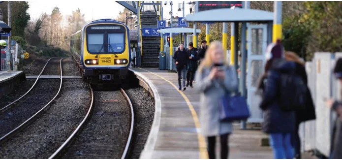
Figure from page 55
This section sets out the measures that the NTA believes are essential in meeting the objectives of the transport strategy to foster sustainable development and to fully integrate land use planning and transport planning, as a means of reducing travel demand both in terms of numbers of trips made and the length of trips.
8.2 Emerging Concepts in Integrated Land Use and Transport Planning
for in a different way. The traditional approach to transport planning was based on analysing historic trends and using those to forecast what is likely to happen in the future – a business as usual or “predict and provide” methodology. As such, throughout the latter half of the 20th century and into the 21st, an assumption was made that economic growth and population growth would lead to greater levels of car and goods traffic, and that rising prosperity would result in higher levels of car ownership and use. It was therefore deemed prudent to predict – using transport models – what that traffic level would be and then to provide the infrastructure to cater for it. This approach has been key to the creation of car-dependent societies and economies and, contrary to its intentions, has led to increased congestion across almost all major urban settlements, with associated environmental and socio-economic dis-benefits.
8.2.1 Avoid-Shift-Improve
Emerging national transport policy approach is based on the Avoid-Shift-Improve principle which can be summarised as follows:
Avoid: Reduce the frequency and distance of trips;
Shift: Move towards more environmentally friendly modes of transport, such as walking, cycling or using public transport; and
A more recently developed approach sets out an alternative process of deciding, on a policy basis, what the most desirable future might be, and then providing the infrastructure and services to deliver that scenario – “Decide and Provide”. For example, an authority might decide that there will be no additional car traffic permitted into the city centre, or that it would reduce, meaning that all growth in the centre would have to be catered for by other modes. The authority would then go about providing the capacity and quality of service required to realise that future.
Improve: Promoting efficient fuel and vehicle technologies.
The measures throughout this Transport Strategy can be categorised under each of these headings. The land use and demand management measures seek to reduce trip lengths and frequency. The public transport, walking and cycling measures seek to engender significant mode shift, and the NTA’s programme of public transport fleet electrification is an example of an improvement.
8.2.2 Decide and Provide
The land use, transport infrastructure and services measures contained in this Transport Strategy are based on the overarching national policy of promoting more sustainable
Following on from the Avoid-Shift-Improve principle, the travel demand that is deemed necessary is required to be planned
transport patterns and reducing transport related greenhouse gas emissions. While car-based transport will continue to be unavoidable for many people, the provision of additional public transport infrastructure and services, together with enhanced cycling and walking facilities, will enable more people to transition to sustainable transport modes. This “Decide and Provide” approach has formed the basis of development of this Transport Strategy.
8.2.3 15-Minute City
The 15-minute city and 10-minute neighbourhood concepts have emerged in recent years and have gained particular traction globally as a result of the Covid-19 pandemic. They have emerged as a coherent means of expressing the need to include transport as a central consideration in the planning and design of urban areas. In essence, these concepts are centred on the premise that people should be able to meet most of their needs within a short walking or cycling distance of their homes.
This does not supersede or replace the concept of the settlement hierarchy whereby land uses which serve metropolitan or regional catchments are provided in larger centres. As such, while everything cannot be within 15 minutes of everyone, (e.g. major universities, specialist health care, or major cultural and sporting venues) many of one’s daily or regular requirements can realistically be met within your own neighbourhood.
The land use measures contained within the Transport Strategy will maintain a focus on this approach and provide a statutory
basis for its implementation in development plans and local area plans. Their application to transport and land use integration in the GDA is set out in the sections below.
A high priority must also be given to cyclists, because trips by this mode have the potential to replace trips by private car, most specifically for short to medium distance trips, but increasingly for longer trips as e-bikes extend the range of this mode.
Due to the significantly greater numbers of people that can be carried by bus and tram, public transport needs to be prioritised over the private car in the design of our transport networks.
Measure PLAN1 – Policy Concepts in Transport and Land Use Planning
Within this hierarchy, the requirements of disabled motorists need to be considered in a different way to those of other private car users. In designing our transport networks and traffic regimes, there is a need to ensure that they are considered carefully, while addressing the overarching imperative to reduce the impact of car traffic and serve the needs of users of mass transit, cyclists and pedestrians. Additionally, the requirements in relation to goods delivery and servicing must be considered.
The NTA, in the implementation of the Transport Strategy and in the development of other plans and programmes, will be guided by emerging concepts in land use and transport planning as they become integrated into the national policy framework.
The road user hierarchy is a fundamental input into the Transport Strategy. Figure 8.1 shows the hierarchy as expressed in the National Sustainable Mobility Policy.
8.3 The Road User Hierarchy
In order to encourage the use of sustainable modes of transport, the design of our networks must consider a hierarchy of users and provide for them in that order, in accordance with the NIFTI Modal Hierarchy.
Measure PLAN2 – The Road User Hierarchy
Almost all journeys begin and end on footpaths. In addition to those who walk for the entirety of journeys, public transport users have to walk or use wheelchairs etc. to get to and from stops and stations and car drivers often need to travel a distance from their parking spaces to shops and places of work. As such, the pedestrian is placed at the top of the user hierarchy.
The NTA, in the decision-making process around the design, planning and funding of transport schemes in the GDA, will be guided by the priority afforded to each mode in the Road User Hierarchy as set out in the Transport Strategy.
Measure PLAN3 – Housing and Transport
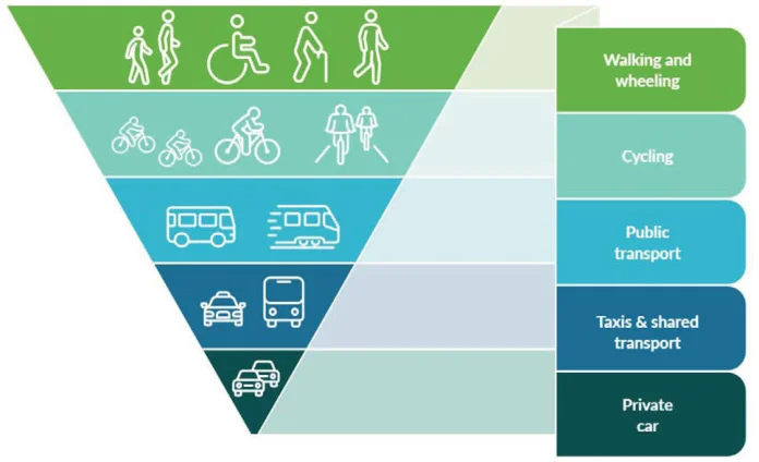
Figure 8.1: Road User Hierarchy
The NTA will continue to support sustainable housing provision in the GDA.
SDZ Planning Schemes, Local Area Plans and large planning applications should be accompanied by appropriate Transport Plans or Transport Assessments setting out how the plan or development minimises the need to travel and how public transport, walking and cycling together can cater for the majority of travel demand. They should also be accompanied by a statement setting out the infrastructure and services required to achieve this, and an agreed phasing programme for its provision.
8.4 Sustainable Delivery of Housing
The NTA is fully engaged with EMRA and the local authorities in this matter and will continue to play its role, via the planning process, in ensuring that demand for housing is met in a timely and sustainable manner.
Facilitating the delivery of large numbers of new housing units of high quality and diversity, in locations which maximise the number and the range of households who can travel by public transport, walking and cycling, is a critical aspect of integrated transport and land use planning in the GDA. All of the major land banks in Metropolitan Dublin which will cater for the demand for housing in the region, in line with the NPF and RSES, are supported by the NTA and will be served by highquality public transport.
8.5 Consolidation of Development
The consolidation of development is a means of ensuring that the negative patterns of urban sprawl and edge of town development cease and are not repeated. The National Planning Framework and Regional Spatial and Economic Strategy are predicated on the redevelopment of sites within the existing footprint of the city and suburbs, and large
regional towns, to a much greater extent than previously applied, with targets of at least 50% of all new homes within or contiguous to the built up area of Dublin city and suburbs and a target of at least 30% for other urban areas.
Additionally the consolidation of development served by sustainable transport reduces the use of greenfield land, protecting biodiversity.
Consolidation of development is at the core of integrated land use and transport planning and one which is fully supported by the Transport Strategy. Figure 8.2 illustrates a mediumhigh density suburban centre typology which would support sustainable transport.
Such an approach allows for new populations to emerge in areas already served by public transport and active travel modes, and where a range of social services and retail can be accessed without recourse to the private car, and without the need to travel long distances. It also facilitates the use of existing infrastructure and service patterns to deliver significant uplifts in accessibility whereby new services can effectively “plug-in” to an already established network. For example, the City Edge Masterplan can benefit from existing rail lines and bus services but also from the major investments in those modes contained in the later sections of this Transport Strategy.
Measure PLAN5 – Retail Development
Major retail developments will be supported at city and town centre locations, at locations which form part of major residential development areas such as Cherrywood or Clonburris or as extensions to legacy retail centres. Major new “out-of-town” retail developments will not be supported.
Measure PLAN4 – Consolidated Development
In accordance with the NPF and RSES, the NTA will support and prioritise development patterns in the GDA which seek to consolidate development as a means of preventing urban sprawl, reducing the demand for long-distance travel and maximising the use of existing transport infrastructure and services.
Measure PLAN6 – Office Developments
Large scale office developments will be supported at city and town centre locations and at locations that fall within the footprint of existing and proposed urban areas served, or proposed to be served, by high quality public transport. Large-scale office developments will not be supported at more peripheral and / or less accessible locations.
Peripheral development will be supported in exceptional circumstances – on an evidence-based planned approach – where located on high capacity public transport routes and for specific land uses that cannot be accommodated in town and city centres.
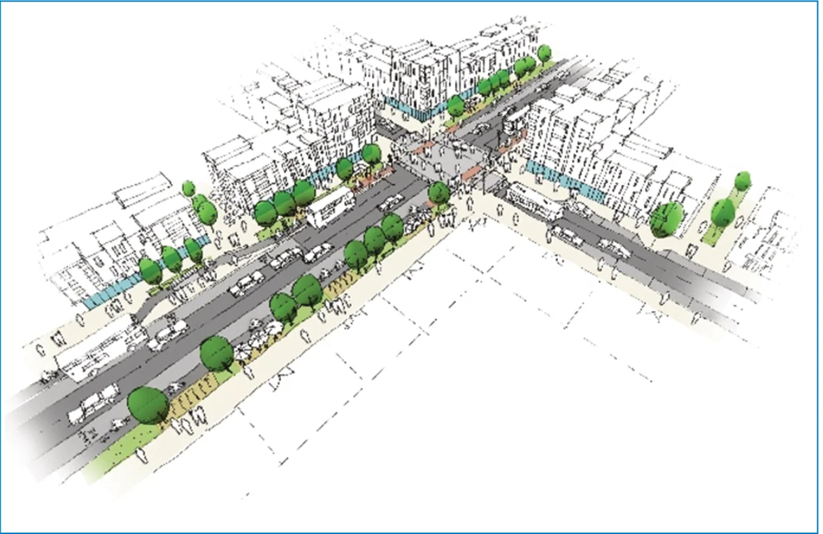
Figure 8.2: Suburban Development Centre
8.6 Transit-Oriented Development
Measure PLAN7 – Transit-Oriented Development
At a level down from the strategic consolidation of development generally into existing built-up areas, the focussing of this development towards public transport services is critical. Transit-Oriented Development (TOD) is a concept that has existed for some time (see Figure 8.3). In the GDA, it has been given expression in recent years by development proposals based primarily on accessibility to existing and proposed rail lines. Most notably, the Adamstown and Cherrywood Strategic Development Zones (SDZs) and the forthcoming City Edge Masterplan are based on servicing a major part of the transport demand by Luas and / or DART.
The NTA will continue to support and facilitate the delivery of Transit-Oriented Development at locations identified as appropriate for such, and will work with EMRA and the local authorities in identifying further locations served by existing and proposed public transport which are appropriate for high density development supporting a mix of uses.
TOD incorporates the idea that the level of accessibility afforded by such infrastructure and services allows for a higher intensity of development, and in some cases, a higher proportion of uses such as office and retail than would ordinarily be considered outside central areas, e.g. Sandyford. TOD can also be applied to sites around city centre transport hubs whereby the levels of accessibility afforded at such locations could facilitate extremely high levels of intensity in the context of Dublin.
For the purposes of TOD, where development could occur at a higher intensity than would normally apply, the following locations are considered as appropriate:
Within 800m of an existing or proposed DART, Luas or Metro stop; and
Within 400m of a proposed BusConnects Spine route.
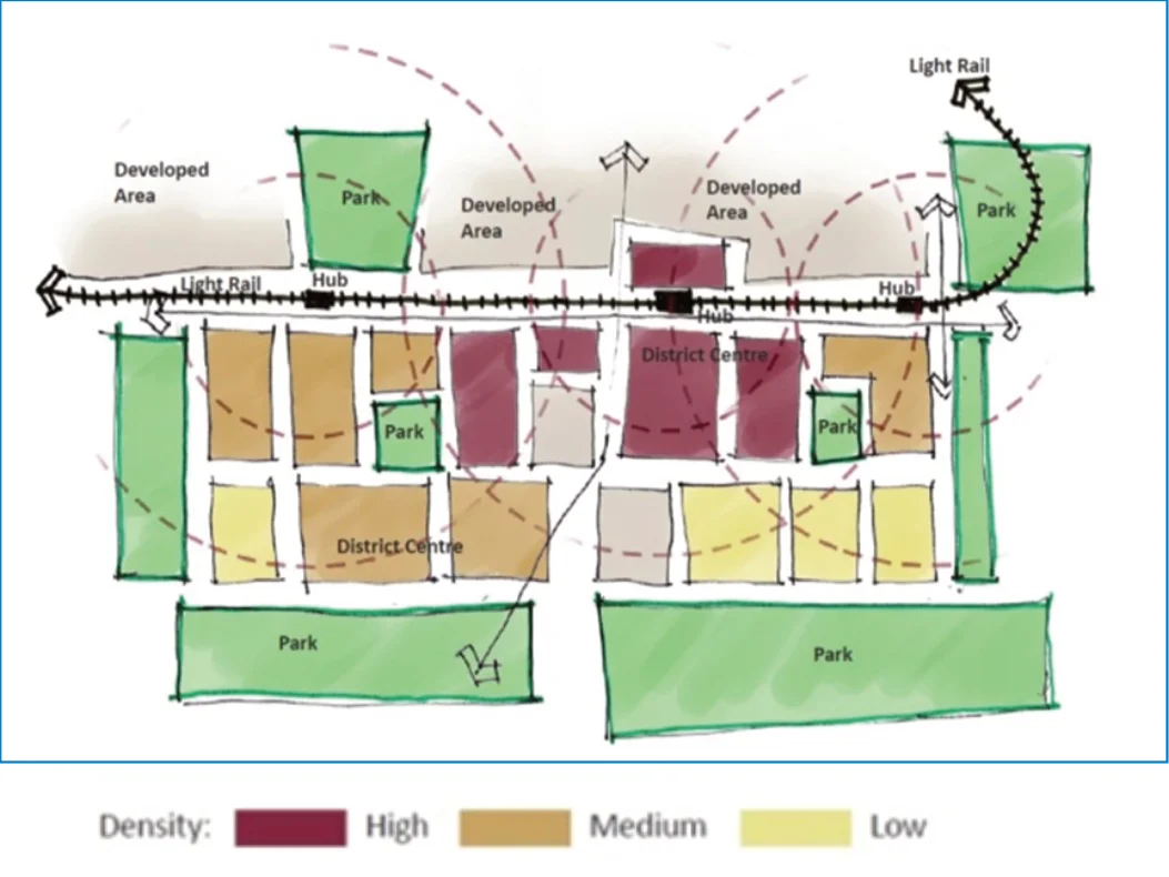
Figure 8.3: Plan of Transit-Oriented DevelopmentCentre
8.7 Mixed Use Development
8.8 Filtered Permeability
At the district or neighbourhood level, and a cornerstone of the 15-minute city concept, is the requirement to provide for an appropriate mix of uses within development areas, an outcome of which is the reduced need for longer distance travel. The traditional planning concept of discrete zonings for housing, industry, employment and recreation simply no longer apply in an era of diverse household types, non-polluting employment, and the increasing desirability to provide for informal and passive recreation as much as more formal playing pitches and parks and gardens. In other words, at the district level, and without compromising city centres and the need for large regional-scale facilities, many of people’s daily needs can be provided within walking and cycling distance of their homes.
Facilitating movement by walking and cycling is a critical element in neighbourhood planning. In particular, the concept of filtered permeability, whereby pedestrians and cyclists can travel through areas and motorised traffic cannot, is important in conferring an advantage on these modes making them safer and more attractive than the car for short trips to local services. This concept has been applied in multiple locations across the GDA, both in new developments and via retrofitting of new links into existing areas.
In existing urban and suburban areas which are defined by culde-sacs and boundary walls which segregate neighbourhoods – often along social class lines – the removal of these physical barriers to allow access for pedestrians and cyclists, including connections to nearby public transport, can be problematic. Many schemes, however, have been successfully realised by the local authorities in the GDA, in collaboration with the NTA.
Measure PLAN8 – Mixed Uses
The NTA will continue to support and facilitate land use policies which seek to provide for an appropriate mix of uses at the district and neighbourhood level.
Measure PLAN9 – Filtered Permeability
Development Plans, SDZ Planning Schemes and Local Area Plans in the GDA should ensure that the road and street networks in new development areas are designed on the basis of providing for filtered permeability, and should incorporate measures which deliver filtered permeability in existing neighbourhoods.
8.9 Planning for Schools
Development of cycling and pedestrian infrastructure serving schools; and
The location and design of schools, and the management of transport requirements for those travelling to schools, are major considerations in land use and transport planning in the city-region.
Managing An Taisce’s Green Schools Travel Module on behalf of Department of Transport.
The latter two items are set out in more detail in the Traffic Management and Behavioural Change sections of this report. This section sets out the core measures for school planning and design which should be considered by the Department of Education and local authorities when zoning for school sites and when designing schools. The ideal of schools being located at the core of a walkable neighbourhood is shown in Figure 8.4.
Only 4% of teenagers cycle to education in the GDA. 32% are driven by car. Nationally, the proportion of children being driven to school has risen from 16% in 1981 to 53% in 2016. The proportion cycling to school nationally has fallen from a peak of 15% to 2%. While these figures do not show the significant geographical variations, the trend has been clear for many years in that the school run has become a prominent challenge for transport planning in the city-region. This gives rise to a number of issues, including:
Measure PLAN10 – School Site Selection
In the site selection process for new schools, sustainable transport shall be a critical consideration. The NTA will support those schools where it can be demonstrated that the majority of students and staff will be able to travel to the school by public transport, walking and cycling.
Congestion at peak hours;
Development of a car-culture instilling driving as the norm at a young age;
Lack of social interaction for children and parents;
Increased air pollution levels at schools; and
Lack of exercise for children leading to obesity and other associated health issues.
Measure PLAN11 – Location of Schools
Development Plans, SDZ Planning Schemes and Local Area Plans in the GDA should ensure that access by walking, cycling and public transport is a key determinant in the location of new schools.
The NTA is addressing school transport issues nationally in three specific ways:
Redesigning urban bus networks to provide enhanced bus services to school locations;
Measure PLAN12 – Design of Schools
Measure PLAN13 – Road Network Serving Schools
Planning for new schools and the expansion of existing schools in the GDA should ensure that the detailed design is undertaken in a manner which maximises the priority for pedestrians and cyclists. Access, footpaths, cycle parking and car parking (if required) should all be arranged so as to eliminate, as far as practicable, interference and conflict between pedestrians, cyclists and motorists.
Planning applications for new schools or the expansion of existing schools will be supported by the NTA only where it has been demonstrated that the road network in the vicinity of the proposed development facilitates, or is planned to facilitate, safe and convenient walking and cycling access to the school.
Where car parking is provided it should be located to the rear or side of school campus in order to reduce the potential for safety hazards and to reduce the visual dominance of cars within the school environment and on the streetscape.
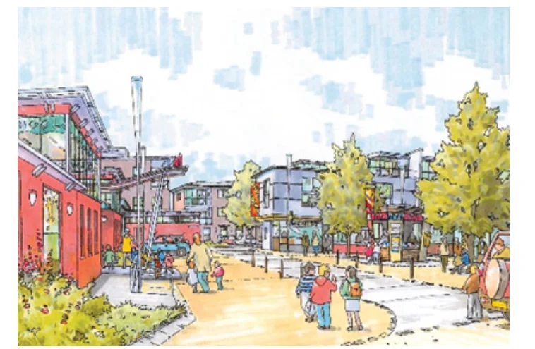
Figure 8.4: Local School in Walkable Neighbourhood Centre
Set down or drop-off areas are not encouraged in close proximity to schools, unless there is no safe alternative area, including on the public road, within a short walk where cars can park safely and with a footpath link to the school.
8.10 Urban Design and Placemaking
Measure PLAN14 – Urban Design in Major Infrastructure Projects
The NTA will incorporate a high standard of urban design and placemaking, taking into account architectural heritage, into the planning and design of all major public transport infrastructure schemes, and will consider how greater biodiversity can be fostered.
Placemaking is the process of creating quality places that people want to live, work, invest and spend time in. It is based on a simple principle; that if you plan for people and places, you get people and places. Increased traffic and congestion is not the inevitable result of growth. It is the product of choices made to shape our communities to accommodate the private car.
Better street design in urban areas, including the presence of active street frontages and facilities such as seating and incidental open spaces, will encourage more people to choose to walk, cycle or use public transport by making the overall experience safer, more accessible and attractive. It will lower traffic speeds, reduce unnecessary car use and create a built environment that responds more sympathetically to the distinctive natures of the individual communities and places across the GDA. The potential also exists to foster greater biodiversity in urban areas through good urban design which takes this issue fully into account.
Measure PLAN15 – Urban Design in Walking and Cycling Projects
In the design, planning and prioritisation of walking and cycling schemes, the NTA and the local authorities will ensure the incorporation of urban design and placemaking considerations, taking into account architectural heritage, and will consider how greater biodiversity could be fostered.
Measure PLAN16 – Reallocation of Road Space
With this in mind, the NTA to date has incorporated high-quality urban design and placemaking improvements into the design of major transport schemes. This policy will continue as part of the implementation of the Transport Strategy. In conjunction with the local authorities, the NTA have also implemented a number of walking and cycling schemes across the GDA which have led to significant enhancements to the urban environment.
The NTA, in conjunction with the local authorities, will seek the reallocation of road space in appropriate locations in Dublin City Centre, Metropolitan towns and villages, and towns and villages across the GDA in accordance with the road user hierarchy, in order to prioritise walking, cycling and public transport use and prioritise the placemaking functions of the urban street network.
8.11 Local Transport Plans
8.12 Implementation of Measures to Integrate Transport and Land Use Planning
The NTA, in conjunction with TII, have developed an advice note which sets out a methodology on how to assess the opportunities and constraints for sustainable transport within an area. This Area Based Transport Assessment (ABTA) methodology has been designed as a key input into Local Transport Plans (as provided for in the NPF and RSES), and can be undertaken in parallel to statutory plans. The ABTA approach should be used to ensure that transport planning and land use planning are fully aligned at the local level and that all opportunities for sustainable transport are maximised.
As a prescribed body for planning matters in the GDA, the NTA is involved at all levels in the planning hierarchy, from the RSES to detailed planning applications.
The NTA cooperates with the EMRA in the making of the RSES and both agencies are required by legislation to ensure that their strategies are consistent. This relationship is set out in detail section 4.4.
Additionally, the RSES sets out that EMRA will work with the NTA and relevant local authorities to prepare Local Transport Plans for selected settlements such as Drogheda, Arklow, Ashbourne, Balbriggan, Naas, Navan, Newbridge, and Wicklow- Rathnew and certain large settlements or development areas within the Dublin Metropolitan Area. The latter would include major regeneration areas such as City Edge and the lands at Jamestown, Finglas.
When making Development Plans and Local Area Plans, local authorities are also required to ensure that they are consistent with the transport strategy. In monitoring these plans, the NTA examine, inter alia, how the following matters have been addressed:
Land use zoning;
Proposed densities;
MEASURE PLAN17 – Local Transport Plans
Car and Cycle parking standards;
The NTA will promote and assist Local Authorities to develop Local Transport Plans based on the ABTA methodology as part of the statutory plan-making process.
Transport investment priorities; and
Protection and support for sustainable transport projects.
The NTA makes recommendations to local authorities through public submissions and cooperates with other agencies such as TII, the Office of the Planning Regulation (OPR) and EMRA in ensuring coordination between plans and programmes.
The above lists are not exhaustive and other matters of land use and transport integration are also considered. In developing and maintaining this relationship between the NTA and the planning process, in collaboration with agencies such as the Eastern and Midland Regional Assembly (EMRA), Transport Infrastructure Ireland (TII) and the Office of the Planning Regulator (OPR), the relationship between transport planning, transport investment and land use planning has become closer. This is reflected primarily in the significant steps towards a more consolidated city-region, as evidenced by most recent land use development trends.
In assessing planning applications, the NTA seek a comprehensive approach from applicants, addressing, inter alia, the following:
A clear policy justification for the location, scale, density and design of the proposed development;
A Transport Assessment setting out how the development is forecast to operate in a sustainable manner;
A statement, including a phasing programme where applicable, setting out how any gaps in the public transport, walking and cycling networks serving a proposed development are to be addressed, including a proposed mechanism for the delivery of appropriate remedial measures, including provision for bus services on site;
A statement setting out how DMURS and the National Cycle Manual have informed the development;
Comprehensive Mobility Management Plans / Travel Plans with clear commitments to their implementation;
Where a development interfaces with an NTA transport scheme, that the development takes this fully into account in the detailed design; and
Provision of the maximum number of bicycle spaces required and the minimum number of car parking spaces required.
Figure from page 72
9. Integration and Inclusion
- Integration and Inclusion
9.1 Introduction
“Mobility plays a vital role in our daily lives and has become a defining factor of current society, the way we live and move. Mobility, or the ability to move from one location to the other, links cultural, economic, social and political aspects of our global society.
Metropolitan and regional transport operates as a network. This network is only as strong as its weakest link and the ability of people to change seamlessly from one mode to another – walking to the bus; cycling to the train station; changing from one bus to another – is critical. The features of a wellintegrated human-centred transport system include the physical environment of stops and stations; the length and quality of the walk between services; crossing points; travel information; fares integration; cycle parking; shelter; frequency and capacity of connecting services.
The global mobility demand continues to grow, along with the mobility systems’ carbon impact. In order to manage future mobility demand, and a much-needed transition to sustainable, low carbon mobility, it will be crucial to achieve seamless transitions from one transport mode to another. The sole provision of transport options will not be enough.”
Transport Integration also encompasses the manner in which the public transport, pedestrian and cycling networks link to other major facilities such as major rail stations, Dublin Port, in particular for passengers wishing to travel by ferry without cars, and Dublin Airport.
Mobility Hubs Of The Future: Towards A New Mobility Behaviour, ARUP, 2020
Finally, Transport Integration relates to the fact that the transport system operates in the context of wider social and cultural norms prevalent in the city region. The manner in which service providers and infrastructure respond to the wide variety of needs across all sectors of society is a central consideration.
In advance of setting out the various strands of investment in the individual modes of transport, this chapter addresses the way in which the NTA will continue to develop these strands into a seamless and inclusive transport network across the GDA over the coming years.
Pages 55–73 · View in original PDF