19 Next Steps
Figure 19.1: Strategy Phasing
Short-Term 2022-2030
BusConnects New Dublin Area Bus Network
Medium Term 2031-2036
BusConnects Core Bus Corridors
MetroLink
Next Generation Ticketing
Luas Finglas
Longer Term 2037-2042
DART+
Navan Rail Line
Luas Green Line Upgrade
Luas Poolbeg
Luas Lucan
City Centre Management Measures
DART Extensions
Luas Bray
Commence Park & Ride
Additional Core Bus Corridors
Complete Park & Ride
GDA Cycle Network
Planning and Design for Additional Luas Lines
Climate Action Management Measures
Planning and Design for DART+ Tunnel
Introduction of Higher Capacity Bus Services
| Continuous Planning, Design, Scheme Development, Consultation and Construction | |
19.2 Monitoring
including the Eastern and Midlands Regional Assembly, and local authorities. It may be necessary to expand some of these data sources to ensure that they are appropriate to fully assess the identified indicators and to ensure that they can be provided in a timely manner to allow for interim reporting.
19.2.1 Introduction
To ensure that the policies and proposals of the Strategy are being implemented in a coordinated, effective and timely manner, it is essential that a robust monitoring programme is put in place. This section details the measures and indicators which will be used to undertake this task.
Examples of sources for monitoring the strategy include:
CSO Census of Population;
CSO National Household Travel Survey;
Monitoring can demonstrate the positive effects facilitated by the Transport Strategy including those relating to improving sustainable transport and meeting our climate change obligations as they relate to transport. Likewise, monitoring can enable, at an early stage, the identification of unforeseen adverse effects which will allow the NTA to undertake appropriate remedial action if required.
NTA Annual Bus and Rail Statistics;
NTA Public Transport Performance Surveys;
NTA / Local Authority Network Development Statistics;
NTA/Dublin City Council Annual Canal Cordon Count;
Annual Local Authority Traffic Counts;
Road Safety Authority Statistics
19.2.2 Objectives and Indicators
Transport Infrastructure Ireland National Roads Network Indicators; and
Monitoring is based around the collation of available indicators which allow quantitative and qualitative measures of trends and progress over time relating to the achievement of the Strategy Objectives as set out in Chapter 5. Monitoring is an ongoing process and the programme will allow for flexibility and the further refinement of indicators.
Environmental Protection Agency Environmental Indicators Reports.
The NTA will continue its liaison and cooperation with the CSO on the methods and frequency of data collection to ensure that information is obtained in a timely and meaningful manner.
19.2.3 Sources
19.2.4 Reporting
Measurements for indicators generally come from existing sources. Existing sources include those maintained by the NTA, TII, Central Statistics Office and other relevant authorities
A Monitoring Report which assesses the implementation of the Strategy against the strategy objectives will be prepared by
2025 in advance of the review of the Strategy. This document will be prepared in parallel to the Monitoring Report prepared for the Strategic Environmental Assessment.
19.3 Considerations for the Review of the RSES
19.3.1 Introduction
This Transport Strategy seeks to provide a transport system which greatly enhances the quality of life for residents, workers and visitors to the GDA, as well as meeting our climate change obligations. The land use policies and assumptions used are set out in the current RSES. The RSES is required to be reviewed periodically, and the next iteration will be required to address the recent updates to National climate change policy. In addition, as set out in legislation, the RSES must be consistent with the Transport Strategy, offering an opportunity to further align the policy direction and integration of land use and transport planning.
This section aims to set out potential considerations for such a review and is based on the following:
Reducing the need to travel;
Ensuring that investment in transport infrastructure and services is optimised to serve sustainable development; and
Prioritising low-carbon modes.
While significant progress has been made in recent years in improving the relationship between land use planning and
transport planning, there are still many instances in which transport has not been a central consideration in, for example, the decision to zone lands for residential or employment uses. At present, there are houses being built in locations in the GDA which present significant challenges to serve by public transport; are beyond reasonable walking and cycling distances of many services; and, as such, residents will be more likely to use the private car than those living in dwellings elsewhere.
As such, there are zoned undeveloped lands across the GDA which are in locations that are not served by high quality public transport; and where walking and cycling for purposes such as commuting to work, college or retail are more challenging than in larger centres or Dublin City and Suburbs. Furthermore, even within Dublin City and Suburbs, there are some zoned areas that are sub-optimal in transport terms.
19.3.3 Accessibility Afforded by Public Transport Corridors
This section sets out one potential pathway towards land use patterns which avoid such development and towards a more consolidated and urbanised future for the GDA which would contribute to Ireland meeting its climate change targets as they relate to transport emissions; and in which less time and resources are expended on travel between homes and workplaces; retail and other uses.
In examining the potential that this Strategy offers land use policy in the GDA, the NTA examined the Dublin Metropolitan area in terms of the accessibility that will be afforded by the public transport network proposed in the Transport Strategy for 2042.
The progress of the recommendations of this chapter will be a matter for EMRA, the local authorities and the OPR, with inputs throughout the development of the RSES and Development Plans from the NTA.
This assessment was based on the Strategic Development Areas and Corridors, set out in Table 5.1 of the EMRA RSES, with a view to identifying key areas at scale with potential to grow, and which were within the catchment of the proposed 2042 strategic public transport network. It is noted that potential growth areas also exist outside the Metropolitan area, but this has not been included in the assessment. The output of this analysis is illustrated in Figure 19.2.
19.3.2 Challenges for Consolidation
In the current RSES, a target of 50% of future population growth is to be located within Dublin City and suburbs. Outside of these locations, significant growth is provided for in regional growth centres, key large towns, smaller settlements and rural areas. Similar policies apply for other land uses such as employment and retail.
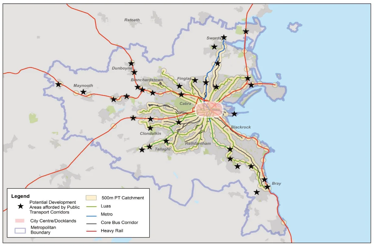
Figure 19.2: Potential Development Areas Afforded by Public Transport Corridors in the Metropolitan Area
19.3.4 Appropriate Locations for Development
Restrictions on the development of peripheral sites zoned for employment to low-intensity uses only which demonstrate low dependency on the use of the private car.
Based on the above map, it is evident that in order to ensure that land use development complements investment in transport and acts as an enabler of the actions required to address climate change, further management of peripheral development is required. As such, and in accordance with the Planning and Development Act, Section 28 Ministerial Guidelines and Departmental Circulars, the NTA will recommend that the Eastern and Midland Regional Assembly, in the preparation of the next Regional Spatial and Economic Strategy, and the local authorities, in preparing their subsequent statutory plans, insofar as is practicable, seek greater levels of development consolidation in the following ways:
19.3.5 Potential Mechanisms for Delivery
To assist in the delivery of integrated land use and transport planning in a manner which will assist in the move towards a low carbon region, the NTA recommends that the on-going review of the legislation, guidance, policies and plans which affect the development of land in the GDA, takes the provisions of the Transport Strategy into account.
This Transport Strategy has set out a major transport investment programme, the benefits of which can only be realised if it is accompanied by complementary land use patterns up to 2042 and beyond. The NTA will contribute to this reform to ensure that the statutory environment in which Exchequer funding for the Transport Strategy is brought forward is appropriate and that transport planning and land use planning are fully integrated.
A greater emphasis on development in Dublin City Centre at a significantly higher density;
A greater emphasis on the consolidation of development into Regional Growth Centres and Key Towns;
Provision for the review of existing zonings for residential and employment development with a view to ensuring development takes place within the 1km walking catchment of an existing or committed future public transport service;
19.3.6 Conclusion
This section sets out an approach that could be taken to further the integration of land use planning and transport planning in the GDA as well as ensuring that our climate change obligations with regard to transport are met. This will form the basis for the NTA’s engagement with the EMRA in the preparation of the next RSES and with Government on the review of the NPF, as well as a framework for how the NTA will interact with Local Authorities in relation to new Development Plans and Local Area Plans.
Policies which ensure that residential developments, other than single rural dwellings, will occur within walking or cycling distance of existing or planned future primary (2km) and secondary schools (3km);
Policies which ensure that school developments will take place within walking and cycling distance of its population catchment;
Changes to the planning system and legislative framework may be required to deliver this, and the NTA will cooperate with all relevant agencies in this regard.
A review of the potential for high intensity residential, employment and mixed use development at key locations within Metropolitan Dublin, where it has been identified that the existing land uses comprise an under-utilisation; and
GLOSSARY
Term Definition
NPF National Planning Framework
AA Appropriate Assessment
NTA National Transport Authority
ABTA Area-Based Transport Assessment
NTP National Technology Park
ACA Architectural Conservation Area
Passive Supervision Informal Security provided by activity and overlooking
Brownfield Development
Regeneration of former industrial lands in urban and suburban areas for other uses
Permeability How convenient it is to Walk and Cycle through an Area
Bus Gate A point on the road network through which only buses and bicycles may pass
PSO Public Service Obligation. Services funded via government grant.
CLC Construction and Logistics Centres
Compact Growth Focussing development of housing and commercial development into existing urban areas
Road User Hierarchy A system of prioritising modes of transport with pedestrians first and private cars last
DMURS Design Manual for Urban Roads and Streets - Government guidance aimed at creating more balanced street
RSES Regional Spatial and Economic Strategy - Overarching regional policy on land use development
EIA Environmental Impact Assessment
RTPI Real Time Passenger Information
EMRA Eastern and Midland Regional Assembly
SAC Special Area of Conservation
GDA Greater Dublin Area – defined by the Dublin Transport Authority Act as Dublin, Kildare, Meath and Wicklow
SDZ Strategic Development Zone - Area for Fast-Track Planning
Greenway Off-road cycling and walking route
SEA Strategic Environmental Assessment
HGV Heavy Goods Vehicle
SPA Special Protection Area
ITS Intelligent Transport Systems - traffic management that adapts to traffic conditions in real time
TEN-T Trans European Network - Transport
TEN-T Comprehensive Network
Network which covers all European regions
LAP Local Area Plan
LTP Local Transport Plan
MaaS Mobility as a Service - the use of technology to support integration and multi-modal travel
TEN-T Core Network
Includes the most important connections, linking the most important nodes
MASP Metropolitan Area Strategic Plan
TfI Transport for Ireland - the national transport brand
NDP National Development Plan
TII Transport Infrastructure Ireland - Agency responsible for National Roads
NIFIT National Investment Framework for Transport in Ireland
TOD Transit-Oriented Development - Development based on high levels of transport accessibility
National Transport Authority Dún Scéine Harcourt Lane Dublin 2
Údarás Náisúnta Iompair Dún Scéine Lána Fhearchair Baile Átha Cliath 2
Tel: +353 1 879 8300
Pages 236–244 · View in original PDF