65 + years
65 + years 12%
0-14 years 21%
45-64 years 23%
15-24 years 12%
25-44 years 32%
Figure 1.7 Age structure – EMRA and State, CSO 2016
Young: In 2016 the age profile of the Region is young with nearly half a million children or 1 in 5 people in the Region that are aged under 14 years of age, rising to 1 in 4 of the population in fast growing counties like Fingal and Laois. The population surge is moving up from primary school age and the number of children of secondary school age children is expected to rise to 2026 and decline thereafter. By 2031 there will be a significant increase in the number of people in the 15-24 years age cohort, which will lead to greater demand for third level education.
Ageing: In line with state-wide trends the population is rapidly ageing. Dún Laoghaire-Rathdown, at an average age of 39 years, is the oldest county in the Region and state. By 2031 there will be a significant increase in the regional population aged over 65 and we need to plan for adequate healthcare, accommodation and services to enable independent living for as long as possible, encourage active lifestyles and address isolation for our older residents.
Diverse: In 2016 the Region is the most demographically diverse in the state, with nearly 300,000 people or more than 1 in 8 residents who are non-Irish nationals, rising to around 1 in 6 in Dublin City, Fingal and Longford counties. Countries of origin include Poland, Lithuania, UK and other EU nationals while migrants from Africa and Asia are mostly concentrated in Dublin. The number of non-Irish nationals fell for the first time between 2011-2016 partly due to the increase in dual citizenship, as more people become Irish citizens.
Labour force: There are over one and a half million people of working age (15 – 64 years) in the Region, a key human capital asset with nearly 1 in 3 of the population in Dublin alone between 25 and 44 years. Labour force growth is set to continue and although its relative share is to decrease, the overall size of the working age population is projected to rise, with increases in the cohorts between 15-29 years and 45-64 years. Accordingly, there will be continued demand for ongoing skills development and also for family homes as well as smaller and one-person households.

Figure from page 17
Introduction
Quality of Life
Placemaking is an essential link between spatial planning, improved quality of life and creating places that are attractive to live, work, visit and invest in. Along with demographic change here are a number of issues to consider when seeking to promote and create healthier places including access to services, housing, sustainable transport and social and economic opportunities.
Housing: The Region is home to over 800,000 households, with 4 out of 5 living in conventional housing while apartments account for around 18% or our housing stock. Homeownership is still the dominant tenure but rental is growing, with 1 in 5 households in the private rental market and 1 in 10 households living in social rented accommodation. One of the challenges facing the Region is the continued growth rates of household formation coupled with a severe slowdown in the development of new housing stock during the economic recession, resulting in housing supply and affordability pressures in both sale and rental markets, particularly in Dublin and urban areas but affecting all of the Region.
Deprivation; The Trutz Haase deprivation index identifies areas of affluence and deprivation in the Region. Dún Laoghaire-Rathdown is the most affluent local authority in the State and the Region, while Longford is the most disadvantaged in the Region and is the third most disadvantaged local authority in the State, see Figure 9.3 (Chapter 9 Quality of Life). However there are pockets of disadvantage across the Region, with 15% of the population living in disadvantaged areas, sometimes in close proximity to areas of relative affluence. Education and skills are closely related to employment opportunities, with rates of third level education highest in Dublin and lowest in the Midlands, while rates of technical/apprenticeships were higher in the Eastern and Midland counties.
Travel patterns; Where there is a mismatch between the locations of jobs and where people live, it leads to long distance commuting, see Figure 1.8 which shows the location of jobs compared to the number of resident workers across the region. The commuter catchment of the Dublin Metropolitan Area now extends into parts of the Midlands, Louth and south into Wexford. While Dublin has higher rates of sustainable transport, private vehicles remain the primary mode of travel to work or education across the whole of the region. Long distance car-based commuting is a key challenge that is leading to congestion of transport networks and negative impacts on people’s quality of life and on the environment.
Employment; The Region has a robust enterprise base of traditional and emerging sectors and strong clusters of universities and research centres to support innovation. A highly skilled labour force has helped the Region attract FDI and multi-national enterprises (MNEs). The Dublin region is a global hub for international investment and high value jobs in ICT, financial and business services while local enterprise and small and medium sized enterprises (SMEs) provide vital employment across the whole of the Region. The Eastern and Midland counties have the highest share of micro-enterprises with specialisations, which include tourism, the equine, food and creative industries.
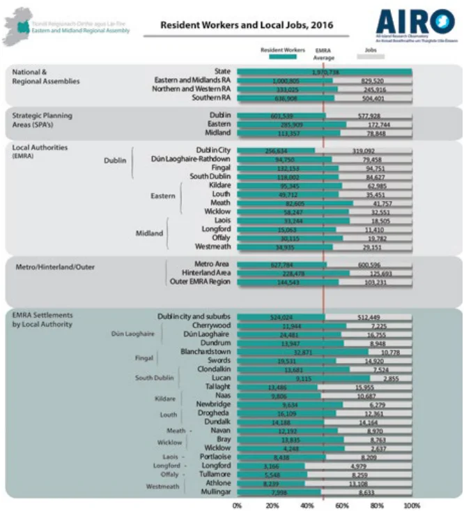
Fig 1.8 Resident Workers and Local Jobs, CSO 2016

Figure from page 18
Regional Spatial & Economic Strategy
Functional Urban Areas (FUAs)
Urban and rural areas can be interconnected to each other through many different social and economic interactions. As the places where people live, work and socialise often extend across local and regional administrative boundaries, an understanding of these cross boundary ‘functional’ areas is needed to help better plan for the provision of infrastructure, transport, housing, services and amenities in our Region.
The National Planning Framework identifies an urban structure for the Region based on commuting patterns, with reference to the EU/OECD definition of ‘functional urban areas’ (FUAs)1 which is used to identify areas with different sub-regional interdependencies and influence in the region. The FUAs support and augment the Strategic Planning Areas (SPAs), which provide for a sub-regional planning remit, through recognising spatial, social and economic similarities and differences within each SPA. These FUAs are;
While the influence of Dublin extends across much of the Region, it is important to recognise that the Region also contains an extensive network of large economically active towns, which provide key services and employment functions for their own hinterlands or ‘Functional Urban Areas’ (FUAs). The size of the FUA, relative to the urban core, shows the influence of these urban centres over their surrounding hinterlands. See Figure 1.9 which shows those large towns4 in the Region that have an identifiable FUA.
See also Appendix E for definition of Functional Urban Areas in the Region.
• The Dublin Metropolitan Area (DMA), home to 1.4 million people in 2016, is the main international gateway to Ireland and includes the continuous built up city area and a number of highly urbanised surrounding settlements within a polycentric metropolitan area. The Metropolitan Area Strategic Plan (MASP) in Chapter 5 identifies a number of large-scale strategic residential and economic development areas, that will deliver significant development in an integrated and sustainable manner in the metropolitan area.
Figure from page 18
• The Core Region; which is the peri-urban ‘hinterlands’2 within the commuter catchment around Dublin, which covers the Eastern counties and extends into the Midlands, north into Louth and south beyond the Region into Wexford. The Core Region is home to over 550,000 people with some of the youngest and fastest growing towns in the Region and the State.
• The Gateway Region3; includes the Midlands and north east border areas, outside the Core Region, which are strategically located as inter-regional portals to the Northern and Western and Southern Regions, where over 400,000 people reside. The Gateway Region also includes the Regional Growth Centres of Athlone and Dundalk, a number of large county towns as well as smaller towns and villages which support the wider rural and agricultural area where the population is more dispersed.
1 The standardised EU/OECD definition of a city region or urban ‘hinterlands’ is the commuter catchment from which are least 15% of the relevant ‘urban core’ workforce is drawn.
2 The functional urban ‘hinterland’ of the Dublin Metropolitan Area includes all Electoral Districts (EDs) where at least 15% of their employed residents are working in the Dublin Metropolitan Area based on Place of Work (POWCAR) 2016 census data.
3 The urban core for this analysis are based on NTA/TII delineations of settlements which are modifications of CSO settlement boundaries to allow for additional local jobs locations outside residential areas.
4 ‘Large towns’ in the Region are towns with a population over 10,000 people or 2,500 local jobs.

Figure from page 19
Introduction
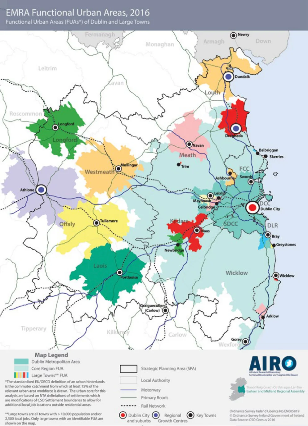
Figure 1.9 Functional Urban Areas, Dublin and Large Towns CSO 2016
Regional Spatial & Economic Strategy
2 Strategic Vision
Pages 16–20 · View in original PDF