7.7 Green Infrastructure
7.7 Green Infrastructure
Green Infrastructure (GI) can be broadly defined as a strategically planned network of high quality natural and semi-natural areas with other environmental features, which is designed and managed to deliver a wide range of ecosystem services and protect biodiversity in both rural and urban settings50.
Placemaking and Green Infrastructure
GI can include areas of high biodiversity value grasslands, wetlands, waterways, peatlands, woodlands and uplands. It can also refer to landscape elements at all spatial scales down to trees, hedgerows, gardens, parks and open space. Blue infrastructure refers to a network of assets which are linked to water such as rivers, canals, lakes, reservoirs, ponds and wetlands. Together they are sometimes referred to as Green and Blue Infrastructure. For the purposes of the RSES, the term Green Infrastructure is used, which seeks to enhance the interrelationships between green (ecology) and blue (hydrology) ecosystems.
GI serves a wide variety of important functions including but not limited to; provision of habitat, increased biodiversity, ecological corridors, climate change adaptation and mitigation, water treatment, water retention, local amenity provision, air quality improvement, cultural and heritage preservation, a mentally restorative environment and flood mitigation.
At the local authority scale, GI offers an opportunity to develop integrated strategies around economic development, urban placemaking and rural policy. Linking strategic natural assets with cultural and heritage assets further enhances the opportunities for GI strategies to drive recreation and tourism benefits. Table 7.1 identifies the strategic GI and cultural heritage assets in the Region.
Integration of GI as a planning concept requires an understanding of where our key strategic natural assets are located, the plants and animals that live there and the human activities that take place. Green Infrastructure policy land use zonings are already embedded in some local authority development plans, allowing for the consideration of GI in local planning policy and decision making.
The multiple benefits of GI are recognised in a number of national policy documents. The National Biodiversity Plan sees GI as crucial to achieving biodiversity targets and developing ecological corridors that allow the movement of species through their entire natural habitat. The Strategy for the Future Development of National and Regional Greenways focuses on the economic and social benefits of creating and connecting greenways, particularly in rural areas, while the Flood Risk Management Guidelines highlight its key role in managing flood risk and adapting to climate change.
The EPA 2016 report ‘Health Benefits from Biodiversity and Green Infrastructure’ states that human health and wellbeing depends on a healthy environment and that management of such a key natural resource also has strategic importance in terms of the potential to contribute to the Irish economy. EMRA is a partner on the EPA-funded project Green and Blue Spaces: A Health-Led Approach (GBI Health). Internationally, large amounts of evidence suggest that access to green and blue spaces provide significant health benefits. GBI Health examined and confirmed the positive influence green and blue spaces have on health and wellbeing in an Irish context. See case study GBI Health, section 9.4 Healthy Placemaking.
50 European Union (2013): Building a Green Infrastructure for Europe.

Table 7.1 Strategic Natural, Cultural and Green Infrastructure Assets in the Region
Environment and Climate
| Table 7.1 Strategic Natural, Cultural and Green Infrastructure Assets in the Region | |
|---|---|
| Bays, estuaries, headlands, islands and reefs | Carlingford Lough, Clogher Head, Dundalk Bay, Boyne Coast and Estuary, Rockabill, Skerries islands, Rogerstown Estuary, Malahide Estuary, Portmarnock, Baldoyle Estuary, Irelands Eye, Lambay Island, Howth Head, Dublin Bay and Tolka Estuary, Bull Island, Booterstown nature reserve, Dalkey Island, The Murragh wetlands, Wicklow Head, Wicklow reef, Maherabeg and Brittas dunes |
| Maritime towns and beaches | Clogherhead, Laytown /Bettystown, Balbriggan, Loughshinny, Rush, Skerries, Portrane, Rush, Donabate, Claremont, Donabate, Malahide, Portmarnock, Dollymount, Sandymount Seapoint, Sandycove, Dalkey, Killiney, Bray, Greystones, Wicklow Town, Maheramore, Brittas, Clogga, Arklow |
| Lakes, Rivers and canals | Loughs Sheelin, Derrvaragh, Ennel, Blessington, Gowna, Owel and Ree, Lough Tay – Lough Dan on the Cloghoge River. Rivers Avonmore, Aughrim, Avoca, Boyne, Barrow, Blackwater, Brosna, Clodagh, Fane, Dee, Dodder, Dargle, Glyde, Inny, Liffey, Nore, Nanny, Poddle, Slate, Santry, Shannon, Slaney and tributary Derry River Tang, Tolka and walks around the Vartry Reservoir Canals; Grand Canal and Royal Canal |
| Greenways, blueways and peatways | Dublin to Galway Eurovelo Route, Green & Silver triangular navigation route encompassing Dublin Royal Canal, River Shannon and Grand Canal, Shannon Wilderness Corridor, East Coast Trail, Newry to Carlingford, Royal and Grand Canal Ways, Canal loop Greenway (linking the Grand and Royal Canals)** Wicklow Way, Dublin Mountains Way, Liffey Valley, Dodder*, Lakelands Greenway, Newgrange to Newbridge Greenway**, Blessington Greenway, Coastal Greenway from Wicklow to Greystones**, Arklow – Shillelagh recreation trail*, Peatways (Corlea, Boora), Barrow and Boyne Blueways |
| Uplands, woodlands and designated sites | Uplands; Cooley Peninsula, Dublin and Wicklow Mountains, Slieve Blooms Woodlands; Knocksink, Glen of the Downs, Charleville Wood SPAs, SACs, NHAs and pNHAs, Ramsar sites See Appendix F |
| Bogs and Peatlands | Abbeyleix Bog, Red Bog, Mouds, Ballynafagh, Moneybeg, Clareisland, Mount Hevey, Scragh, Crosswood, Carn Park, Garriskil, Derragh, Wooddown, Girley (Drewstown), Killyconny, Brown Bog , Clooneen, Ardagullion, Mount Jessop, All Saints, Clara, Raheenmore, Ferbane, Sharavogue, Moyclare, Mongan, Derry, Coolrain, Lisbigney, Knockacoller, Holdenstown, Carriggower Bog |
| National and Regional Parks | Wicklow Mountains National Park, The Curragh Plains, Japanese Gardens, Birr Castle, Lough Boora Discovery Park, Charleville, Emo Court, Heywood Gardens, Tullynally Castle and Belvedere House and gardens. Argillan House and Gardens, Castletown house and attendant demesnes, Newbridge demesne, Oldbridge demesne, Phoenix Park, Ward Valley Park, Tymon Park, Marlay Park, Killiney Hill, Dodder Valley Park, Griffeen Valley Park, and Corkagh Park. Avondale and Kilmacurragh, Lough Ree and Mid-Shannon Wilderness Park and Lanesborough Commons North Park. |
| Medieval, historic and walled towns. | Medieval towns of Carlingford, Drogheda, Kildare, Naas, Trim and Athlone. Historic planned towns of Birr, Abbeyleix, Castlepollard and Tyrellspass. Walled towns of Ardee, Carlingford, Drogheda, Castledermot, Athy, Athlone, Naas, Trim and Dublin. |
| Heritage sites | Bru na Boinne-Boyne Valley UNESCO World Heritage Site, Dublin Bay UNESCO biosphere, Proposed; Historic city of Dublin, Monastic sites at Clonmacnoise, Durrow, Kells, Monasterboice and Glendalough. Royal sites of Ireland at Dun Aillne, Hill of Uisneach and Tara Complex. Curragh Plains, Baltinglass cluster of hillforts, Clondalkin (Clondalkin Round Tower), and Rathfarnham (Rathfarnham Castle). See also Record of National monuments |
*under development
**proposed

Figure from page 166
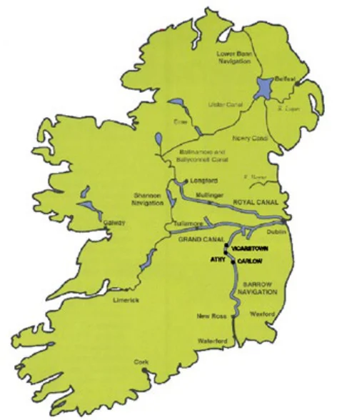
Figure 7.3 Navigational map of the Region’s main Green/Blueway routes51
GUIDING PRINCIPLES
In the preparation of Green Infrastructure Strategies, local authorities shall follow these Guiding Principles;
• Identify and protect existing GI Assets - before development (including spatial mapping where appropriate) and enhance the potential of the existing network through the development of new GI assets during development processes.
• Connectivity is key – interconnect GI assets with each other and with people, providing linkages from built up areas to the countryside. This includes wildlife corridors between areas of high biodiversity value and the development of greenways, blueways and peatways.
• Consider the ecological impacts of greenways – while the development of greenways and blueways has positive health and wellbeing benefits, there is also potential for habitat loss and disturbance due to increased movement of people. Therefore there is a need to strategically plan, deliver and manage our GI networks and ensure appropriately designed infrastructure to reduce the impact on the natural environment.
• Integrate an ecosystem services approach – addressing biodiversity protection, water management and climate action in the planning and management of green spaces, for example provision of street trees, roadside hedges, planting wildflower meadows, introducing wildlife underand over-passes, permeable surfaces and SuDS along connecting routes and green walls and roofs on buildings.
• Design GI strategies that function at different scales and across boundaries – to this end local authorities should work with their neighbouring authorities to co-ordinate GI strategies and with infrastructure providers to seek out opportunities to develop GI along strategic infrastructure corridors.
• Carbon Sequestration – local authorities should consider the potential for carbon sequestration in GI Strategies, whereby certain areas can be considered as strategic and integral mechanism for the longterm storage of carbon to mitigate the contribution of fossil fuels emissions and combat climate change.
• Integrate built and natural heritage – provide links between walking and cycling routes particularly in areas of high amenity, uplands, lake shores, river banks, forests with built heritage sites, areas of historic or archaeological importance and National Monuments. The development of waymarked ways and looped walks can maximise recreation and tourism benefits to local populations but may require the creation of new rights of way either by agreement or by the use of compulsory powers.

Figure from page 167
Environment and Climate
Development of Greenways, Blueways and Peatways
REGIONAL POLICY OBJECTIVES:
The Strategy for the Future Development of National and Regional Greenways Strategy 2018 by the Department of Transport, Tourism, and Sport sets out how National and Regional Greenways in Ireland should be planned and constructed and sets out a framework for funding of Greenway projects.
Green Infrastructure
RPO 7.22: Local authority development plan and local area plans, shall identify, protect, enhance, provide and manage Green Infrastructure in an integrated and coherent manner and should also have regard to the required targets in relation to the conservation of European sites, other nature conservation sites, ecological networks, and protected species.
The aim is to develop national (at least 100 kilometres long) and regional (at least 20 kilometres, but preferably 40 kilometres long) trail networks as a unique alternative means for tourists and visitors to access and enjoy rural Ireland, helping to support the development of rural communities and job creation, as well as protecting and promoting natural assets and biodiversity. The greenways strategy is closely aligned to the National Outdoor Recreation Plan to link into state owned recreation areas including Coillte trails, Bord na Mona peatlands and Waterways Ireland.
RPO 7.23: Support the further development of Green Infrastructure policies and coordinate the mapping of strategic Green Infrastructure in the Region.
Figure from page 167

Figure from page 168
Regional Spatial & Economic Strategy
There are significant opportunities to develop a number of flagship greenways in the Region;
REGIONAL POLICY OBJECTIVE:
Greenways, Blueways and Peatways
Greenways; The Dublin – Galway greenway offers potential to link the marketing of the Wild Atlantic Way, Ireland’s Ancient East and the Hidden Heartlands and connect to the EuroVelo network of long-distance European cycling trails. Other regional greenways under development include the East Coast trail with potential to extend cross border to the Newry to Carlingford Greenway and the Old Rail Trail between Athlone to Mullingar, which highlights the potential to develop disused railway lines in the Region. The Blessington Greenway – approved extension around Blessington Lake, taking in the surrounding villages of Lackan and Ballyknockan and offers the potential to attract people to work and visit the area and surrounding villages. The Wicklow Way hiking route from Dublin to the Blackstairs Mountains would benefit from improved facilities and connections into the informal mountain walks in Wicklow Mountains National Park.
RPO 7.24: Promote the development of a sustainable Strategic Greenway Network of national and regional routes, with a number of high capacity flagship routes that can be extended and /or linked with local greenways and other cycling and walking infrastructure, notwithstanding that capacity of a greenway is limited to what is ecologically sustainable.
RPO 7.25: Support local authorities and state agencies in the delivery of sustainable strategic greenways, blueways, and peatways projects in the Region under the Strategy for the Future Development of National and Regional Greenways.
REGIONAL POLICY OBJECTIVE:
Blueways; The development of navigable inland waterways in collaboration with Waterways Ireland including; the Shannon and Shannon-Erne connecting the islands of Lough Ree, Clonmacmoise and Shannon harbour; linking the Royal Canal with the Grand Canal along the River Shannon; the Barrow Way from Lowtown to Graiguecullen / Carlow; and the emerging Boyne Blueway. There is further potential to position the Dublin Docklands as a significant water-focussed amenity and develop the Grand Canal and Spencer Docks as the urban gateways to the Grand and Royal Canals. Blueways are particularly important for water quality, fisheries and ecological habitats, and for activities such as kayaking and snorkelling.
Riparian setbacks
RPO 7.26 Support the development of guidance for assessment of proposed land zonings in order to achieve appropriate riparian setback distances that support the attainment of high ecological status for waterbodies, the conservation of biodiversity and good ecosystem health, and buffer zones from flood plains.
Peatways; There is potential in the midlands to develop a regional peatway interconnecting a range of biodiversity and cultural hotspots such as the Mesolithic (first settlers) site in Lough Boora, Co. Offaly and the Iron Age bog road in Corlea, Co.Longford. There is also potential to enhance access and link into trails in the Slieve Bloom Mountains in Ireland’s central plain.
Careful routing and design is needed to ensure that greenways do not impact negatively on agriculture, natural heritage or the biodiversity value of natural ecological corridors such as rivers and canals or on coastal habitats. Planning has a key role to play in developing and connecting the regional greenway network for nature conservation, recreation and tourism to support the diversification of rural economies and promote more sustainable travel modes, particularly in urban areas, see also Chapter 5 MASP for greenways in the Dublin Metropolitan Area.

Figure from page 169
Environment and Climate
Pages 164–169 · View in original PDF