5.9 Green Infrastructure and Amenities
5.9 Green Infrastructure and Amenities
Green Infrastructure (GI) can be broadly defined as a strategically planned network of high quality natural and semi-natural areas with other environmental features, which is designed and managed to deliver a wide range of ecosystem services and protect biodiversity in both rural and urban settings
Metropolitan scale GI includes natural features such as rivers and canals, our coastline, regional parks, agricultural lands and amenity sites, forming a network of interconnected natural, semi-natural and managed areas that weaves through the metropolitan area, conserving natural ecosystems, managing flood risk and providing health and recreation benefits to people.
REGIONAL POLICY OBJECTIVES:
MASP Green Infrastructure
RPO 5.7: Co-ordinate across local authority boundaries to identify, manage, develop and protect regional Green Infrastructure, to enhance strategic connections and develop a Green Infrastructure policy in the Dublin Metropolitan Area.
In the Dublin Metropolitan Area strategic assets include; Dublin Bay and the marine SAC from Rockabill to Dalkey; the east coast estuaries, islands and headlands, linked by the East Coast Way; the Dublin/Wicklow Mountains including the Wicklow National Park and the Wicklow Way; Special Amenity Areas at North Bull Island, Howth and Liffey Valley SAAOs; UNESCO designated sites of Dublin Bay Biosphere16 (see case study) and the Historic city of Dublin (tentative); water corridors including the Rivers Liffey, Tolka, Santry, Mayne, Poddle, Camac, Griffeen, Dodder, Ward and Broadmeadow, the Grand and Royal Canals and regional parks including; Liffey Valley, Phoenix Park, Ward Valley Park, Tymon Park, Marlay Park, Killiney Hill, Father Collins Park and the proposed Dunsink and Swords Regional Parks.
RPO 5.8: Support the promotion and development of greenway infrastructure and facilities in the Dublin metropolitan area and to support the expansion and connections between key strategic cycle routes and greenways as set out in the NTA Greater Dublin Area Cycle Network Plan.
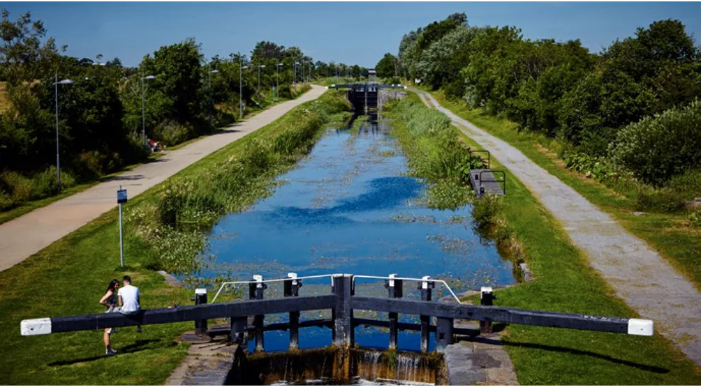
Figure from page 116
16 http://www.dublinbaybiosphere.ie/

Figure from page 117
CASE STUDY:
Dublin Bay Biosphere In 1981, UNESCO designated North Bull Island as a Biosphere because of its rare and internationally important habitats and species. In 2015, the Biosphere was expanded to over 300 km2 of Dublin Bay, reflecting its significant environmental, economic, cultural and tourism importance and to promote wider goals of conservation, learning and sustainable development. The Dublin Bay Biosphere is the world’s only Biosphere located largely within a capital city.
The Biosphere comprises three zones; the core zone of high natural value including the Tolka and Baldoyle Estuaries, Booterstown Marsh, Howth Head, North Bull Island, Dalkey Island and Ireland’s Eye; the surrounding buffer zone of parks, golf courses and green spaces and; the wider transition zone including residential areas, harbours, ports, industrial and commercial areas. Over 300,000 people live within the newly enlarged Biosphere.

Figure from page 118
Regional Spatial & Economic Strategy
Metropolitan Greenbelt
The principles of GI recognise the importance of semi natural and managed lands as well as wild and natural areas. Green belt and rural /agriculture land use zonings form a natural greenbelt around the built-up area of Dublin City and suburbs and some metropolitan settlements, and provides a defined natural envelope for development. Land use zonings related to green infrastructure and rural/agricultural landuses17 form a baseline for the metropolitan greenbelt including;
CASE STUDY:
Enhancing Resilience of urban ecosystems through Green Infrastructure (EnRoute)
EnRoute is an EU funded project to support knowledge exchange in the development of urban Green Infrastructure (GI) across 20 cities in Europe including the Dublin Region. The Irish project team included EMRA, the National Parks and Wildlife Service (NPWS), Government departments (DAHRG, DHPLG), local authorities (LAs) and the Dublin Bay Biosphere Partnership.
• Dublin Bay and the Coastal Zone (East)
• Dublin/Wicklow mountains (South)
En Route produced a common set of data and indicators (based on the MAES framework) to assess and monitor the performance of urban GI in terms of ecosystem services and condition. The selection of indicators is based on local needs and includes;
• Zoned Greenbelt, agricultural lands and airport lands (North and West)
• Liffey Valley, Phoenix Park and the Metropolitan Greenway Network (‘green fingers’ connecting rural to urban).
• Ecosystem services including; recreation, pollination, coastal protection, microclimate regulation, air quality, noise reduction, carbon sequestration, flood protection and water quality.
The EMRA supports the further development of Green Infrastructure policies in the metropolitan area to support the compact development of Dublin and the metropolitan settlements. The identification and mapping of GI assets supports the development of policies for their management and for the further development of strategic connections. The EU funded En Route project applied an ecosystem services approach18 to support the development of Green Infrastructure policy in the Dublin region, utilising NPWS National Ecosystem Services mapping pilot19 and Myplan.ie General Zone Types (GZTs)20 to identify areas of importance for conservation and nature based recreation, see case study below and Figure 5.5. Refer also to Chapter 7 Environment & Climate - Guiding Principles for Green Infrastructure.
• Urban ecosystem condition including; habitat conversion and land degradation, climate change, pollution, introduction of alien species, environmental quality, urban greenspace and contaminated sites.
17 Myplan.ie General Zone Types (GZTs) including ‘green’ (G) recreation, conservation, corridor/belt, amenity and open space and ‘primary’(P) rural/ agricultural land uses
18 http://ec.europa.eu/environment/nature/knowledge/ecosystem_assessment/
20 http://www.myplan.ie/viewer/gztcoderef.htm

Figure from page 119
Dublin Metropolitan Area Strategic Plan (MASP)
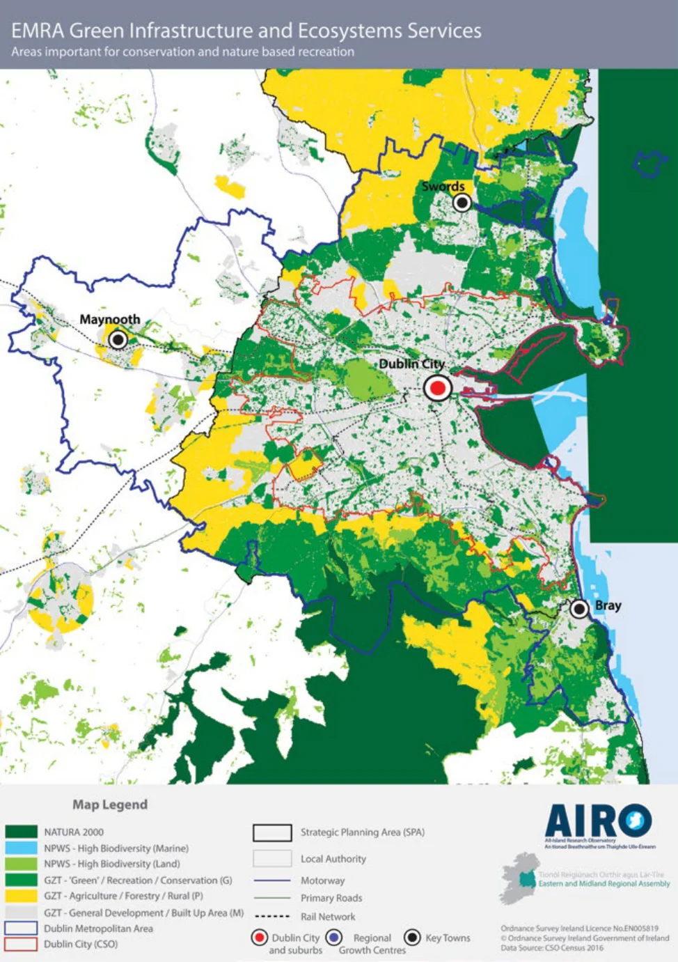
Figure 5.5 Green Infrastruture and Ecosystem services
Economy & Employment
Pages 116–120 · View in original PDF