5.6 Integrated Land use and Transportation
5.6 Integrated Land use and Transportation
The principles underpinning the development of the MASP include the effective integration of transport planning with spatial planning policies, from regional down to local level and the alignment of associated transport and infrastructure investment priorities. The national policy in metropolitan areas is to increase sustainability through greater alignment of land use and transport. The NTA’s Transport Strategy for the Greater Dublin Area (2016) provides a framework for the planning and delivery of transport infrastructure and services in the Greater Dublin Area (GDA) over the period 2016 - 2035. The alignment of the MASP and the GDA Transport Strategy is key to the coordination of policy making and investment within the Dublin Metropolitan Area.
To the extent practicable, development within the metropolitan area should be carried out sequentially, whereby lands which are, or will be, most accessible by walking, cycling and public transport – including infill and brownfield sites – are prioritised. The transport capacity of the strategic national road network should also be maintained and protected and larger scale, trip intensive developments, such as high employment density offices and retail, should primarily be focused in locations which are well served by existing or proposed high capacity public transport corridors.
REGIONAL POLICY OBJECTIVES:
MASP Sustainable Transport
RPO 5.2: Support the delivery of key sustainable transport projects including Metrolink, DART and LUAS expansion programmes, BusConnects and the Greater Dublin Metropolitan Cycle Network and ensure that future development maximises the efficiency and protects the strategic capacity of the metropolitan area transport network, existing and planned.
RPO 5.3: Future development in the Dublin Metropolitan Area shall be planned and designed in a manner that facilitates sustainable travel patterns, with a particular focus on increasing the share of active modes (walking and cycling) and public transport use and creating a safe attractive street environment for pedestrians and cyclists.
Figure from page 107

Figure from page 108
Regional Spatial & Economic Strategy
| Key transport infrastructure investments in the metropolitan area as set out in national policy include; | |
|---|---|
| Dublin -Belfast Economic Corridor | New and Enhanced Park and Ride |
| The Strategy supports the development of the Dublin - | New Park and Ride locations at Swords, |
| Belfast Economic Corridor through targeted investment in transport infrastructure and services complementing and maintaining its function as part of the EU TEN-T core network. See Chapter 8 Connectivity for further information. | Finglas, Dunboyne, Liffey Valley, Naas Road, Carrickmines, Woodbrook, Greystones |
| Bus | |
| Within the Dublin Metropolitan Area, investment | |
| Rail; | |
| • DART Expansion Programme - new infrastructure and | in bus based public transport will be delivered through BusConnects, which aims to overhaul the |
| electrification of existing lines, including provision of electrified services to Drogheda or further north on the Northern Line, Celbridge-Hazelhatch or further south on the Kildare Line, Maynooth and M3 Parkway on the Maynooth/Sligo Line, while continuing to provide DART services on the South-Eastern Line as far south as Greystones | current bus system in the Dublin metropolitan area, including the introduction of Bus Rapid Transit. |
| Roads | |
| • M4 Maynooth to Leixlip | |
| • M11 from Jn 4 M50 to Kilmacanogue | |
| • New stations to provide interchanges with bus, LUAS | • N3 Clonee to M50 |
| and Metro network including at Kishoge, Heuston West, Cabra, Glasnevin, Pelletstown and Woodbrook | |
| • M50 Dublin Port South Access | |
| • Reappraisal of the extension of the Dunboyne/M3 | |
| Parkway line to Navan during the Mid Term Review of the GDA Transport Strategy, see also Chapter 8 Connectivity | |
| • Complete construction of Metrolink from | |
| Swords to Sandyford and consider underground extensions to other locations from Charlemont | |
| • LUAS Green Line Capacity Enhancement | |
| in advance of Metrolink | |
| • Appraisal, planning and design of LUAS network | |
| expansion to Bray, Finglas, Lucan and Poolbeg | |
| • Assessment, and, if appropriate, planning and design of | |
| LUAS network expansion to Hazelhatch and Booterstown | |
| • In principle there is a need to carry out an evaluation | |
| of underground metro routes within the M50 |

Figure from page 109
Dublin Metropolitan Area Strategic Plan (MASP)
Walking and Cycling
Metropolitan Greenway Network
Facilitating modal shift to more sustainable transport options, including walking and cycling is a key element in promoting better traffic management and climate change strategies in the metropolitan area. The NTA Greater Dublin Area Cycle Network Plan sets out a strategy to enhance the urban network and develop the primary urban cycle arteries, which include the Royal Canal and Grand Canal ring and the Rivers Liffey, Tolka and Dodder, see Figure 5.3 (Primary urban cycle network shown in red).
Greenways are high quality cycleways, which are generally segregated from traffic and often routed through parks and areas of high amenity value such as coastal, canal and riverside routes. Where greenways pass through a designated environmental area, careful environmental assessment, routing and design will be required to avoid significant impacts on habitats and species. See Chapter 7 Environment for more information on Greenways and Blueways in a regional context.
Outside of the city an inter-urban cycle network extends to the surrounding metropolitan towns to provide new connections between Dublin and towns in Fingal, Kildare, Meath, and Wicklow, to develop urban – rural connections and provide attractive commuting routes.
A number of greenways are of strategic value in terms of their length as an amenity, as a means of providing access to major recreational areas in the mountains, on the coast or in significant public parks, and also as part of a connected Strategic Metropolitan Greenway Network.
The expansion of shared-bike schemes can also make a positive contribution to sustainable transport and mobility within the wider metropolitan area.
Strategic Greenways proposed and/or under development in the metropolitan area include:
• East Coast Route from Sutton to Sandymount with potential to link into a Dublin Port Greenway, to extend north to link into the Fingal Coastal Way and to develop a wider East Coast Trail from Rosslare to Northern Ireland
• Royal Canal Greenway from Spencer Dock through the northern inner suburbs along the canal to Maynooth and Mullingar with potential to link into the Dublin to Galway Eurovelo route
• Grand Canal Greenway from Docklands through the southern inner suburbs to Naas, Newbridge and Kildare joining the Barrow Way at Athy with potential to link to Cork
• River Liffey Greenway from Dublin Port along the Liffey Quays to Leixlip. Cross-connections are proposed through the Phoenix Park linking the Royal Canal to the Grand Canal
• Dodder Valley Greenway from Grand Canal Dock along the river corridor which passes largely through public parks in the southern suburbs to Bohernabreena, with potential to develop links to the Dublin Mountains and Wicklow Way
• Western Canals Loop a proposed 40km long recreational city loop linking the Grand Canal at Adamstown to the Royal Canal at Leixlip via Griffeen Valley Park, Lucan and the Liffey Valley.
There is also potential for strategic radial routes to link into other greenways such as the Rivers Tolka, Santry, Poddle and Camac greenways to provide for local links and enhanced recreational opportunities, see Figure 5.3 (Greenway Network shown in green).

Figure from page 110
Regional Spatial & Economic Strategy
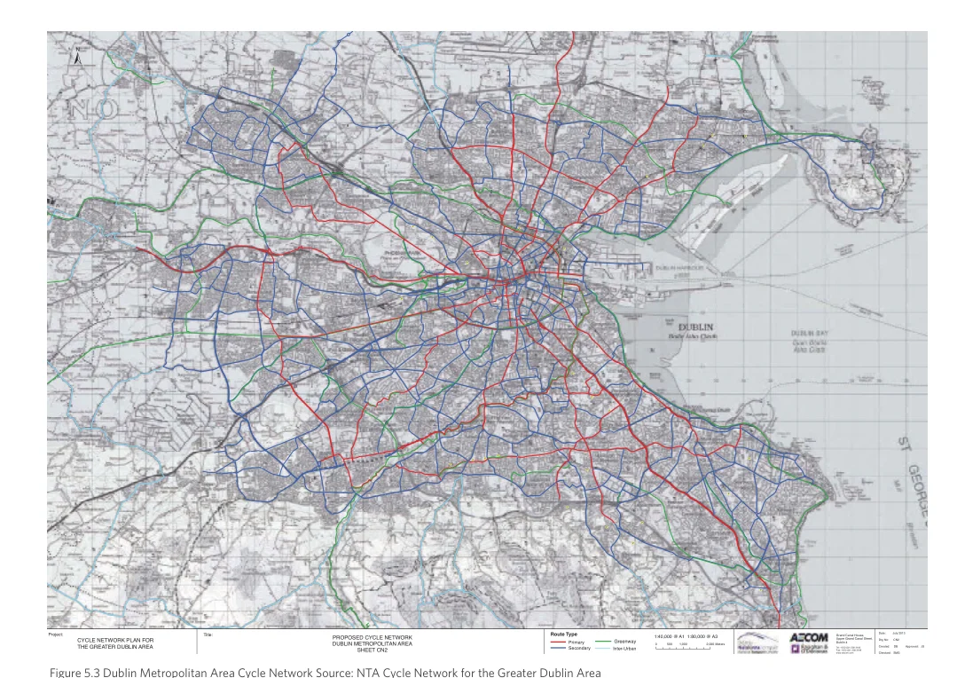
Figure from page 110
| ± P ( P ( (P (P (P (P (P P ( P ( | (P P ( (P P ( (P P ( (P P ( (P (P (P (P P ( (P (P (P (P | |
|---|---|---|
| Project: C THY EC L GE R N EE AT TW ERO DR UK BP LL IA NN A RFO EAR Title: DPR UO BLP IO NS ME SED HT EC R EY O TC P L COE NL IN 2TE AT NW AO RR EK A | Route Ty P Sp eri cme oa nr dy ary IG ntr ee re -Un rw ba any 1 0:40,00 500 0 @ A 1,01 0 0 1:80,000 @ 2,00 A 03 Meters GUD TFeapur lx:a :pb + +n 3eli 35d nr 53 3GC 4 ( 0(ra 0)a 1)n 1 n 2 a 2d 3l 3 8 8HC 3 3o 1a 10un 90s 9ael ,Street, | Date: July 2013 Drg No: CN2 Created: DB Approved: JS |
Figure 5.3 Dublin Metropolitan Area Cycle Network Source: NTA Cycle Network for the Greater Dublin Area
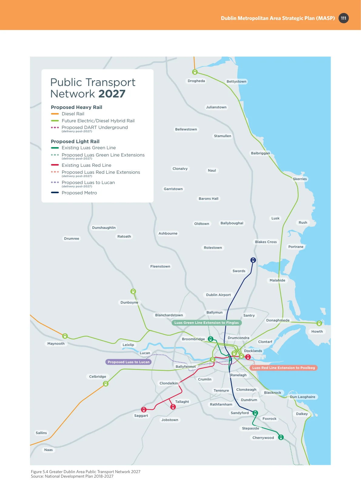
Figure from page 111
Dublin Metropolitan Area Strategic Plan (MASP)
Bettystown
Julianstown
Stamullen
Balbriggan
Naul
Skerries
Barons Hall
Lusk Rush
Ballyboughal Oldtown
Blakes Cross
Portrane
Rolestown
Swords
Malahide
Dublin Airport
Ballymun
Santry
Donaghmede
Luas Green Line Extension to Finglas
Finglas
Howth
Drumcondra Clontarf
Docklands
Luas Red Line Extension to Poolbeg
Ringsend
Ranelagh
Crumlin
Clonskeagh Terenure
Blackrock Dun Laoghaire
Dundrum
Rathfarnham
Sandyford
Dalkey
Foxrock
Stepaside
Cherrywood

Figure from page 112
Regional Spatial & Economic Strategy
Pages 107–112 · View in original PDF