5.4 Metropolitan Area Strategy
5.4 Metropolitan Area Strategy
Strategic residential and employment development corridors are identified in the MASP, to create sustainable compact communities with improved housing choice, access to social and economic opportunities, enhanced services and amenities for a resident population of some 1.65m people in the metropolitan area by 2031.
Strategic development corridors include;
City Centre within the M50 (Multi modal) The ongoing regeneration of Dublin Docklands and Poolbeg, coupled with the redevelopment of older social housing (former PPPs), industrial and underutilised lands, support the consolidation of Dublin City. The proposed DART Underground and LUAS extensions to Finglas and Lucan subject to appraisal and delivery post 2027, will unlock long-term capacity including strategic landbanks such as Dunsink.
The criteria for identifying the corridors involved a selection of strategic development opportunities identified by local authorities and included an evidence-based analysis of their current and future development capacity and their potential to deliver agreed strategic outcomes such as; compact development; placemaking; accessibility to high quality public transport corridors; potential for economic development and employment creation and to support a reduced carbon footprint through greater energy efficiency and the creation of energy districts.
North – South Corridor (DART expansion) The DART Expansion Programme, to be delivered by 2027 will increase capacity on the northern commuter line and support ongoing large-scale urban expansion of the North Fringe lands and Donabate. On the south-eastern commuter line capacity is unlocked by a new station at Woodbrook - Shanganagh, with the consolidation and westward expansion of Bray to Fassaroe and Old Conna linked to improved public transport connections.
North - West Corridor (Maynooth/Dunboyne line and DART expansion) Strategic development areas along the Dunboyne/M3 parkway line include the Dublin Enterprise Zone (linked to improved bus connections), Hansfield lands and the sequential development of lands in Dunboyne served by the M3 Parkway station. The proposed electrification of the main Maynooth line, to be delivered by 2027, will support sequential growth in Leixlip and Maynooth.
A phased sequence of infrastructure investment is identified to enable the accelerated delivery of strategic development corridors both within the short term to 2026; medium term in the lifetime of the RSES to 2031; and to the long term horizon of the NPF to 2040. MASP is also aligned with the National Strategic Outcomes of the NPF and NDP to ensure that it can inform national-level sectoral investment plans and co-ordinate investment within the metropolitan area through a €2 Billion Urban Regeneration Fund and the establishment of a national Land Development Agency.
South - West Corridor (Kildare line, DART expansion and Luas red line) The consolidation of the western suburbs of Clonburris, Kilcarbery and Adamstown, linked to increased capacity and electrified services on the Kildare line, to be delivered by 2027, and at Grangecastle supported by additional bus connections. Brownfield regeneration lands at Naas Road and Tallaght and new residential communities at Fortunestown, supported by the LUAS redline.
To achieve ambitious compact development targets of at least 50% of all new homes within or contiguous to the existing built up area in Dublin and 30% in other settlements, the MASP identifies strategic residential, employment and regeneration development opportunities on the corridors along with the requisite infrastructure investment needed to ensure a steady supply of sites in tandem with the delivery of key public transport projects as set out in the NDP, see Fig 5.2 and Table 5.1.
Metrolink - LUAS Corridor (Metrolink, LUAS green line upgrades) The development of the proposed Metrolink project, subject to appraisal and delivery post 2027, will unlock significant long-term capacity in Swords-Lissenhall and in South Fingal - Dublin Airport, subject to the protection of airport capacity and accessibility. Proposed upgrades to the existing LUAS Green line will support development in the south county at Sandyford, Cherrywood and Ballyogan.

Figure from page 103
Dublin Metropolitan Area Strategic Plan (MASP)
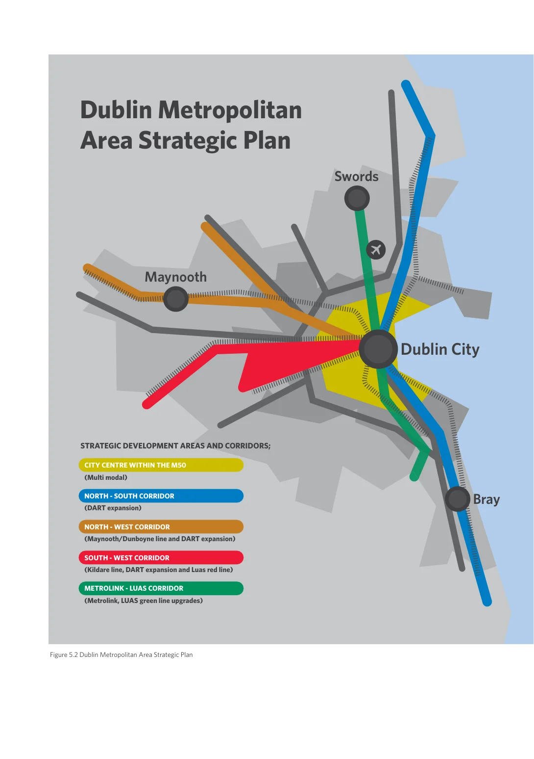
Figure from page 103
Swords
Dublin City
Bray

TABLE 5.1 Strategic Development Areas and Corridors, Capacity Infrastructure and Phasing
Regional Spatial & Economic Strategy
| TABLE 5.1 Strategic Development Areas and Corridors, Capacity Infrastructure and Phasing | |||
|---|---|---|---|
| Corridor | Residential | Employment/ Mixed Use | Phasing/Enabling infrastructure |
| City Centre within the M50 (Multi-modal) Population capacity Short 35,000 Medium 10,000 Long 15,000 Total 60,000 | Docklands build out of North Lotts and Grand Canal Docks with further physical and social regeneration of Poolbeg and northeast inner-city lands | Further development of people intensive high tech and services- based business districts in Docklands and Poolbeg | Short to Medium term Dodder bridge, LUAS extension to Poolbeg, local and wider area water upgrades, waste water upgrades and district heating |
| City centre regeneration of older social housing projects (former PPPs), Parkwest-Cherry Orchard, Ballymun, Ashtown-Pelletstown and St James – Heuston lands | Regeneration of Diageo lands, health and education related employment at St James and Grangegorman campus | Short to Medium term Waste water upgrades, social infrastructure Long term Long term capacity supported by DART underground | |
| Naas Road /Ballymount – significant brownfield lands in South Dublin and Dublin City Council areas, with potential for residential development and more intensive employment/ mixed uses | Re-intensification of underutilised lands including Naas road and older industrial estates, subject to feasibility study | Medium to Long term Multi-modal public transport, new Luas stop, site assembly, waste water upgrades and local area water network upgrades | |
| Dunsink – major greenfield landbank with long term potential to develop a new district centre | Subject to feasibility | Long term LUAS extension to Finglas, access, site conditions, feasibility | |
| North-South corridor (DART) Population capacity Short 31,000 Medium 13,000 Long 7,000 Total 51,000 | North Fringe – large scale urban expansion creating new communities at Clongriffin-Belmayne (Dublin City) and Baldoyle-Stapolin (Fingal) | Completion of mixed-use districts with retail and service provision | Short to Medium term Access to rail station, bus upgrades, new road connections, drainage, parks and social infrastructure |
| Donabate – significant residential capacity in this strategically located rapidly growing coastal village | Consolidation of economic and service base in tandem with population growth | Short term DART expansion, distributor road and railway bridge, social infrastructure, local area water network and storage upgrades | |
| South County Dublin - North Wicklow – development of new residential communities at Woodbrook- Shanganagh and Bray Golf course and Harbour lands | Strengthening commercial town functions in Bray, developing IDA strategic site in Greystones to strengthen economic base in North Wicklow | Short term Access road, new station at Woodbrook - Shanganagh. Access to Bray station and PT bridge. | |
| Bray Fassaroe* – westward extension of Bray at Old Connaught- Fassaroe (Dún Laoghaire) and Bray -Fassaroe (Wicklow) lands | New mixed use residential and employment district at Fassaroe, west of Bray Greystones Strategic site | Short to Medium term High capacity bus between Bray and Fassaroe, distributor road, N/ M11 upgrades, new bridge to Old Conna. Waste water upgrades. Local and wider area water network and storage upgrades Long term LUAS extension to Bray |

Figure from page 105
Dublin Metropolitan Area Strategic Plan (MASP)
| Corridor | Residential | Employment/ Mixed Use | Phasing/Enabling infrastructure |
|---|---|---|---|
| North-West corridor (Maynooth/ Dunboyne commuter line /DART) Population capacity Short 24,000 Medium 10,000 Long 3,000 Total 37,000 | Dublin 15 lands – continued development of Hansfield linked to the future development of Barnhill and Kellytown landbanks to the south and east | Further development of large- scale employment in Dublin Enterprise Zone** and synergies with Blanchardstown IT | Short term Public transport, Clonsilla Station, water network and waste water upgrades. |
| Leixlip – strategic greenfield lands near Confey station with capacity for phased development, improve links to Leixlip and adjoining Dublin/Meath lands | Large scale former Hewlett Packard site and Collinstown site to strengthen employment base for North Kildare | Short to Medium term LUAS extension to Maynooth, roads upgrades, community and social infrastructure, waste water and local water network upgrades | |
| Maynooth – Significant strategic residential capacity at Railpark lands and to the north and west of the town near Maynooth University | New Research & technology Park adjoining Maynooth University | Short to Medium term DART expansion, road upgrades, bridge, Maynooth Outer Orbital Route, waste water and local water network upgrades | |
| Dunboyne – Sequential development prioritising zoned and serviced lands near the railway station and town centre and at Dunboyne North / M3 Parkway station | Space intensive ‘big box’ employment at Portan. Mixed use ‘live - work’ development at Dunboyne North | Medium to Long term Outer Orbital road, distributor road, additional watermains and waste water upgrades | |
| South western corridor (Kildare line/ DART and LUAS redline) Population capacity Short 45,000 Medium 21,000 Total 66,000 | Western suburbs - Continued development of Adamstown SDZ and the phased development of Clonburris located strategically between the west Dublin suburbs of Lucan and Clondalkin. New residential community at Kilcarbery near Clondalkin. | Promotion of high tech, manufacturing and research and development in Grange Castle Business Park | Short to Medium term New roads and railway bridge, new rail station, DART expansion to Celbridge- Hazelhatch (Adamstown, Clonburris) Access road and waste water upgrades (Kilcarbery). Public transport and access (Grange Castle). New water network infrastructure to supply Clonburris SDZ and local network upgrades |
| LUAS red line - Regeneration of brownfield lands in Tallaght. New district at Fortunestown near emerging town of Saggart/Citywest | Re-intensification of older industrial estates at Naas Road/ Ballymount, Intensification of industrial lands and mixed- use development at Tallaght Town Centre/Cookstown | Short to Medium term Brownfield conditions and site assembly waste water upgrades and Citywest junction link at Tallaght/Fortunestown | |
| Metrolink / LUAS Greenline Corridor (Metrolink/ LUAS) Population capacity Short 28,000 Medium 25,000 Long 18,000 Total 71,000 | Dún Laoghaire - Rathdown – New and emerging mixed-use districts of Cherrywood and Sandyford. New residential communities in Ballyogan and environs and Kiltiernan-Glenamuck | Continued development of high-density business districts at Cherrywood and Sandyford. New mixed use centres in Ballyogan and Kiltiernan | Short to Medium term LUAS green line upgrades. Public transport and roads upgrades. New road and bridge and N11 junction (Cherrywood) and water upgrades |
| Swords – sequential development of strategic residential sites within Swords and development of Oldtown-Mooretown lands | Airport related, commercial facilities and employment linked to development of Metrolink | Short to Medium term Public realm, pedestrian and cyclist provision. Road improvements, BusConnects. Additional runway and improved access (Airport). Waste water upgrades. Local and wider area water network upgrades | |
| Swords – Lissenhall – new mixed-use urban district on the northern side of Swords linked to delivery of Metrolink | Development of high-tech research and development employment within a campus setting at Lissenhall East | Medium to Long term Improved bus connections, Metrolink, roads improvements and expanded internal road network and waste water upgrades |
*Development at Fassaroe will be undertaken in collaboration between Wicklow County Council, Dún Laoghaire-Rathdown County Council and the transport agencies **Dublin Enterprise Zone is not directly served by existing or planned rail and will require improve bus connections and demand management measures

Figure from page 106
Regional Spatial & Economic Strategy
Pages 102–106 · View in original PDF