4.1 Introduction and context
4.1 Introduction and context
This chapter sets out a settlement hierarchy and the identification of key growth areas in the Region that will see significant development up to 2031 and beyond. The Settlement Strategy will build on the policy direction adopted by the previous Regional Planning Guidelines (RPGs) to facilitate growth that is directed towards a number of key designated settlements as part of an integrated land use and transportation strategy to achieve more co-ordinated and sustainable settlement and travel patterns across the Region.
The Regional Spatial and Economic Strategy (RSES) supports the implementation of National Policy Objectives and targets contained in Project Ireland 2040 - National Planning Framework (NPF) and alignment with the investment priorities of the National Development Plan 2018-27 (NDP) by coupling new development with the requisite investment in services and infrastructure.
The three overarching key principles of healthy placemaking, climate action and economic opportunity are all key drivers of this chapter. The Settlement Strategy is also informed by a number of key Regional Strategic Outcomes such as the provision of sustainable settlement patterns, compact growth, sustainable rural development, integrated transport and landuse, sustainable management of environmental resources, enhanced regional connectivity and enhanced green infrastructure.
Planning plays a central role in creating places that enhance people’s quality of life, and consequently health and wellbeing. Placemaking and quality of life is increasingly recognised as a key factor in attracting investment, skills and talent (see Chapter 9 Quality of Life).
The Strategy is informed by an evidence driven Settlement Typology and Asset-Based approach, which identifies key assets and capacity issues in the Region’s settlements and seeks to ensure that all places can meet their full potential and support the health and wellbeing of people who live, work, study in or visit the Region as well as the environment with which they interact.
Figure from page 43
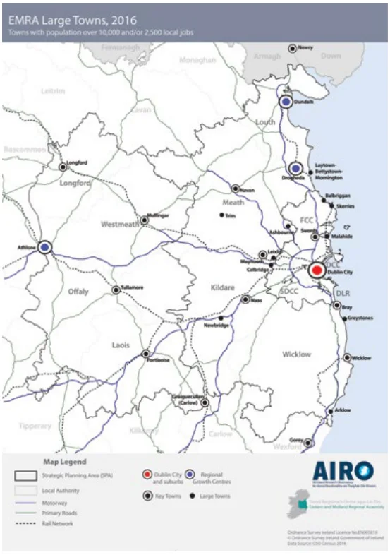
Figure 4.1 EMRA Large Towns (> 10,000 population)
Context
It is clear that the RSES, while looking at the coherence of the Region as a whole, should have the ability to respond to the different needs of different areas, including between urban and rural. There is an extensive urban settlement pattern in the Region with 24 settlements with a population over 10,000 people and a further 21 settlements with a population over 4,000 (see Figure 4.1). It contains a city and suburbs, large towns, small towns and villages and the rural countryside. Whilst Dublin is dominant in the Region, there are different areas within the Region, characterised by their location and relationship to the Capital City. These have been identified in the Growth Strategy as the Metropolitan Area, The Core Region and The Gateway Region. Within these areas the urban structure has different pressures and opportunities. This difference in context is reflected in the policy responses of the RSES.

Table 4.1 NPF Population Projections
Regional Spatial & Economic Strategy
Pages 42–44 · View in original PDF